
Otago is a region of New Zealand located in the southern half of the South Island administered by the Otago Regional Council. It has an area of approximately 32,000 square kilometres (12,000 sq mi), making it the country's second largest local government region. Its population was 254,600 in June 2023.

The Clutha River is the second longest river in New Zealand and the longest in the South Island. It flows south-southeast 338 kilometres (210 mi) through Central and South Otago from Lake Wānaka in the Southern Alps to the Pacific Ocean, 75 kilometres (47 mi) south west of Dunedin. It is the highest volume river in New Zealand, and the swiftest, with a catchment of 21,000 square kilometres (8,100 sq mi), discharging a mean flow of 614 cubic metres per second (21,700 cu ft/s). The river is known for its scenery, gold-rush history, and swift turquoise waters. A river conservation group, the Clutha Mata-Au River Parkway Group, is working to establish a regional river parkway, with a trail, along the entire river corridor.

Dunedin is the second-largest city in the South Island of New Zealand, and the principal city of the Otago region. Its name comes from Dùn Èideann, the Scottish Gaelic name for Edinburgh, the capital of Scotland. The city has a rich Māori, Scottish, and Chinese heritage.
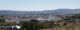
Mosgiel is an urban satellite of Dunedin in Otago, New Zealand, fifteen kilometres west of the city's centre. Since the re-organisation of New Zealand local government in 1989 it has been inside the Dunedin City Council area. Mosgiel has a population of approximately 14,800 as of June 2023. A nickname for Mosgiel is "The pearl of the plain". Its low-lying nature does pose problems, making it prone to flooding after heavy rains. Mosgiel takes its name from Mossgiel Farm, Ayrshire, the farm of the poet Robert Burns, the uncle of the co-founder in 1848 of the Otago settlement, the Reverend Thomas Burns.

The Taieri River is the fourth-longest river in New Zealand and is in Otago in the South Island. Rising in the Lammerlaw Range, it initially flows north, then east around the Rock and Pillar range before turning southeast, reaching the sea 30 kilometres (19 mi) south of Dunedin.
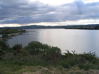
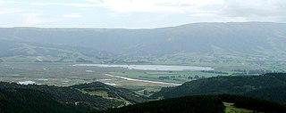
Lake Waihola is a 640 ha tidal freshwater lake located 15 km north of Milton in Otago, in New Zealand's South Island. Its area is some 9 square kilometres, with a maximum length of 6 kilometres and a mean depth of 0.75m.
The Taieri Plain is an area of fertile agricultural land to the southwest of Dunedin, in Otago, New Zealand. The plain covers an area of some 300 square kilometres, with a maximum extent of 30 kilometres. It is not to be confused with Strath Taieri, a second plain of the Taieri River, 40kms to the north beyond Mount Ross.

The Waipori River is in Otago in the South Island of New Zealand. Rising in the Lammerlaw Range, it flows southeast for 50 kilometres (31 mi) before joining the Taieri River near Henley, 30 kilometres (19 mi) southwest of Dunedin of which it is officially the southernmost border. Google Maps erroneously shows the stretch of Taieri river from the confluence to the mouth as Waipori River. The correct name is shown on the New Zealand government's official NZ Topo Map.
South Otago lies in the south east of the South Island of New Zealand. As the name suggests, it forms the southernmost part of the geographical region of Otago.
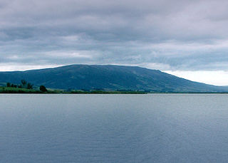
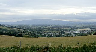
Maungatua, known also as Maukaatua is a prominent ridge in the Taieri Plains in Otago, New Zealand.
The Sinclair Wetlands are an internationally renowned wetlands located to the south west of Dunedin, New Zealand, at the southern edge of the Taieri Plains. They are on the western side of Lake Waipori and approximately equidistant between Mosgiel and Milton. The protected area covers a little over 315 Ha 3 km2.

Taieri Mouth is a small fishing village at the mouth of the Taieri River, New Zealand. Taieri Island (Moturata) lies in the ocean several hundred metres off the river's mouth.

The Strath Taieri is a large glacial valley and river plateau in New Zealand's South Island. It is surrounded by the rugged hill ranges to the north and west of Otago Harbour. Since 1989 it has been part of the city of Dunedin. The small town of Middlemarch is located at its southern end.
Lake Waipori is the smaller and shallower of the pair of lakes located in the wetlands to the south west of Dunedin in New Zealand on the Waipori River. The Waipori River is a major tributary of the Taieri River, and these wetlands form the southern edge of the Taieri Plains.
Momona is a small town on the Taieri Plain in New Zealand's South Island. Momona School was established in 1899 and closed in 2004. The Henley Co-operative Dairy Company, established in nearby Henley, moved their cheese factory here, and was closed in the 1980s.

Clutha District is a local government district of southern New Zealand, with its headquarters in the Otago town of Balclutha. Clutha District has a land area of 6,334.47 km2 (2,445.75 sq mi) and an estimated population of 18,900 as of June 2023. Clutha District occupies the majority of the geographical area known as South Otago.

Outram is a rural suburb of Dunedin, New Zealand, with a population of 880 as of June 2023. It is located 28 kilometres west of the central city at the edge of the Taieri Plains, close to the foot of Maungatua. The Taieri River flows close to the southeast of the town. Outram lies on State Highway 87 between Mosgiel and Middlemarch.
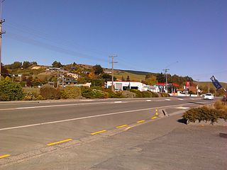
Allanton is a small town in Otago, New Zealand, located some 20 kilometres southwest of Dunedin on State Highway 1. The settlement lies at the eastern edge of the Taieri Plains close to the Taieri River at the junction of the main road to Dunedin International Airport at Momona.
The township of Waihola lies between Dunedin and Milton, New Zealand in Otago, in New Zealand's South Island. It lies close to the southeast shore of the shallow tidal lake which shares its name.
East Taieri is a small township, located between Mosgiel and Allanton in New Zealand's Otago region. It lies on State Highway 1 en route between the city of Dunedin and its airport at Momona. It lies close to the southeastern edge of the Taieri Plain, hence its name.

