Lake Waihola

Last updated

Lake Waihola
Lake Waihola.jpg
Lake Waihola
Lake Waihola
Otago Map Physical New Zealand.jpg
Red pog.svg
Lake Waihola
Location Clutha District, Otago Region, South Island
Coordinates 46°01′S170°06′E / 46.017°S 170.100°E / -46.017; 170.100
Primary outflows Waipori River
Basin  countriesNew Zealand
Surface area9 km2 (3.5 sq mi)
Looking north towards Maungatua Maungatua2.jpg
Looking north towards Maungatua

Lake Waihola is a 640 ha tidal freshwater lake located 15 km north of Milton in Otago, in New Zealand's South Island. Its area is some 9 square kilometres, with a maximum length of 6 kilometres and a mean depth of 0.75m. [1]

Contents

It is the larger of a pair of existing lakesthe other being Lake Waipori which lie in a small area of low hills between the Taieri and Tokomairaro. Waihola is drained by the Waipori River, a tributary of the Taieri. Both lakes are very shallow and surrounded by wetlands, including the internationally renowned and protected Sinclair Wetlands which are the home to many species of wading birds. This shallowness is reflected in the name Waihola, the southern Māori form of the word waihora, which means "spreading waters".

Lake Waihola is a popular day trip for holidaymakers from Dunedin, 40 km to the north. The small township of Waihola (population 200), nestled against the lake's eastern edge, has facilities for fishing, yachting, and waterskiing, and the lake is an important rowing venue.

History

Lake Waihola was used in the Otago gold rush. Ships used to travel up the Taieri River and across to the southern side of the lake where prospectors would traverse the hills and on to Gabriel's Gully. In the early days of settlement a paddle-steamer, the Betsy Douglas, plied the lake's waters from Owhiro, near Henley in the north to Clarendon at the lake's southern end.

Lake Waihola is located at the southern end of the lower Taieri Plains and is the largest of a group of historical lakes that were once distributed between Lake Waihola and Mosgiel. Other neighbouring historical lakes include Lake Tatawai, Loch Ascog, Loch Katrine, Lake Potaka and Silverstream Lagoon [2]

Etymology

Waihola's name creates some interest as the Māori alphabet generally does not contain the letter 'L'. It is, however, found in Southern Māori dialect, [3] and is also found in several other central and southern South Island place names, such as Wangaloa in Otago and Little Akaloa in Canterbury. The word Waihola is generally accepted to be the southern variant of the word wai-hora, meaning "spreading waters".

Ecosystems

Lake Waihola has attracted international interest due to the ecosystems based in a shallow freshwater tidal system. Since 2000, Danish scientists have been conducting annual studies of the lake. Waihola is reputedly the home to a species of otter, the cryptid waitoreke, but no verified sightings have ever confirmed the animal's existence. [4]

Waihola panorama.jpg
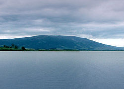
Panorama of Lake Waihola, seen from the hills to the southeast. Part of the settlement of Waihola is visible in the centre of the image.

Health warnings

Health warnings related to algae have been issued on the lake as of March 2017. [5]

See also

Related Research Articles

<span class="mw-page-title-main">Clutha River</span> River in the South Island of New Zealand

The Clutha River is the second longest river in New Zealand and the longest in the South Island. It flows south-southeast 338 kilometres (210 mi) through Central and South Otago from Lake Wānaka in the Southern Alps to the Pacific Ocean, 75 kilometres (47 mi) south west of Dunedin. It is the highest volume river in New Zealand, and the swiftest, with a catchment of 21,000 square kilometres (8,100 sq mi), discharging a mean flow of 614 cubic metres per second (21,700 cu ft/s). The river is known for its scenery, gold-rush history, and swift turquoise waters. A river conservation group, the Clutha Mata-Au River Parkway Group, is working to establish a regional river parkway, with a trail, along the entire river corridor.

<span class="mw-page-title-main">Henley, New Zealand</span> Human settlement in Dunedin City, Otago Region, New Zealand

Henley is a township on New Zealand's Taieri Plains, named after the rowing centre Henley-on-Thames in England. It lies close to the confluence of the Taieri and Waipori Rivers at the eastern edge of the plain, at the foot of a low range of coastal hills. The township lies close to the ecologically significant Sinclair Wetlands, which lie 3.5 kilometres (2.2 mi) to the west.

<span class="mw-page-title-main">Dunedin</span> City in Otago, New Zealand

Dunedin is the second-largest city in the South Island of New Zealand, and the principal city of the Otago region. Its name comes from Dùn Èideann, the Scottish Gaelic name for Edinburgh, the capital of Scotland. The city has a rich Māori, Scottish, and Chinese heritage.

<span class="mw-page-title-main">Mosgiel</span> Town in Otago, New Zealand

Mosgiel is an urban satellite of Dunedin in Otago, New Zealand, fifteen kilometres west of the city's centre. Since the re-organisation of New Zealand local government in 1989 it has been inside the Dunedin City Council area. Mosgiel has a population of approximately 14,800 as of June 2023. A nickname for Mosgiel is "The pearl of the plain". Its low-lying nature does pose problems, making it prone to flooding after heavy rains. Mosgiel takes its name from Mossgiel Farm, Ayrshire, the farm of the poet Robert Burns, the uncle of the co-founder in 1848 of the Otago settlement, the Reverend Thomas Burns.

<span class="mw-page-title-main">Taieri River</span> River in New Zealand

The Taieri River is the fourth-longest river in New Zealand and is in Otago in the South Island. Rising in the Lammerlaw Range, it initially flows north, then east around the Rock and Pillar range before turning southeast, reaching the sea 30 kilometres (19 mi) south of Dunedin.

<span class="mw-page-title-main">Taieri Plain</span> Plain in New Zealand

The Taieri Plain is an area of fertile agricultural land to the southwest of Dunedin, in Otago, New Zealand. The plain covers an area of some 300 square kilometres, with a maximum extent of 30 kilometres. It is not to be confused with Strath Taieri, a second plain of the Taieri River, 40kms to the north beyond Mount Ross.

<span class="mw-page-title-main">Waipori River</span> River in New Zealand

The Waipori River is in Otago in the South Island of New Zealand. Rising in the Lammerlaw Range, it flows southeast for 50 kilometres (31 mi) before joining the Taieri River near Henley, 30 kilometres (19 mi) southwest of Dunedin of which it is officially the southernmost border. Google Maps erroneously shows the stretch of Taieri river from the confluence to the mouth as Waipori River. The correct name is shown on the New Zealand government's official NZ Topo Map.

South Otago lies in the south east of the South Island of New Zealand. As the name suggests, it forms the southernmost part of the geographical region of Otago.

<span class="mw-page-title-main">Maungatua</span> Hill in Otago, New Zealand

Maungatua, known also as Mauka Atua is a prominent ridge in the Taieri Plains in Otago, New Zealand.

<span class="mw-page-title-main">Sinclair Wetlands</span>

The Sinclair Wetlands are an internationally renowned wetlands located to the south west of Dunedin, New Zealand, at the southern edge of the Taieri Plains. They are on the western side of Lake Waipori and approximately equidistant between Mosgiel and Milton. The protected area covers a little over 315 Ha 3 km2.

<span class="mw-page-title-main">Lake Mahinerangi</span> Reservoir in Otago Region, South Island

Lake Mahinerangi is a lake formed when a dam was built on the Waipori River for hydroelectric generation. The lake is 35 kilometres (22 mi) to the west of Dunedin in New Zealand's South Island. Construction of the dam started in 1903 and since 1907, power has been produced.

<span class="mw-page-title-main">Taieri Mouth</span> Rural settlement in Otago, New Zealand

Taieri Mouth is a small fishing village at the mouth of the Taieri River, New Zealand. Taieri Island (Moturata) lies in the ocean several hundred metres off the river's mouth.

<span class="mw-page-title-main">Lake Waipori</span> Lake in New Zealand

Lake Waipori is the smaller and shallower of the pair of lakes located in the wetlands to the south west of Dunedin in New Zealand on the Waipori River. The Waipori River is a major tributary of the Taieri River, and these wetlands form the southern edge of the Taieri Plains.

<span class="mw-page-title-main">Clutha District</span> Territorial authority district in Otago, New Zealand

Clutha District is a local government district of southern New Zealand, with its headquarters in the Otago town of Balclutha. Clutha District has a land area of 6,334.47 km2 (2,445.75 sq mi) and an estimated population of 18,900 as of June 2023. Clutha District occupies the majority of the geographical area known as South Otago.

<span class="mw-page-title-main">Lake Tuakitoto</span> Lake in New Zealand

Lake Tuakitoto is a small lake in South Otago, on the South Island of New Zealand. It is located to the northeast of Balclutha, close to the small town of Kaitangata. The smallest of South Otago's three main lakes, it is, like the others very shallow. The lake drains into the lower reaches of the Clutha River.

<span class="mw-page-title-main">Eldon's galaxias</span> Species of fish

Eldon's galaxias is an endangered galaxiid fish endemic to New Zealand. One of several fishes in the genus Galaxias found in Central Otago, it has a very small home range and is at risk of being driven to extinction by trout introduced for recreational fishing.

<span class="mw-page-title-main">Saddle Hill (New Zealand)</span> Hill in Dunedin, Otago Region, New Zealand

Saddle Hill is a prominent landmark overlooking the northeastern end of the Taieri Plains in Otago, New Zealand. Within the limits of Dunedin city, it is located 18 kilometres to the west of the city centre, between Mosgiel and Green Island, and is clearly visible from many of the city's southern hill suburbs. A lookout on the northern slopes of the hill commands a good view across the plains, with Lake Waihola visible 25 kilometres to the west in clear weather.

<span class="mw-page-title-main">Waihola</span> Town in Otago, New Zealand

The township of Waihola lies between Dunedin and Milton, New Zealand in Otago, in New Zealand's South Island. It lies close to the southeast shore of the shallow tidal lake which shares its name.

Lake Tatawai was a tidal freshwater lake located immediately north of Lake Waipori in Otago, in New Zealand's South Island.

References

  1. "OTAGO CONSERVANCY" (PDF). www.doc.govt.nz. Retrieved 28 June 2020.
  2. Bray, Sharon. "Under the Eye of the Saddle Hill Taniwha", 1998.
  3. Macalister, John (2004). "Listening to Proper Nouns: Social Change and Maori Proper Noun Use in New Zealand English" (PDF). New Zealand English Journal. 18: 28. Retrieved 24 June 2018.
  4. New Zealand Ecological Society report (PDF format).
  5. "New health warning for Lake Waihola". Otago Daily Times Online News. 7 March 2017.