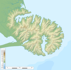
Banks Peninsula is a peninsula of volcanic origin on the east coast of the South Island of New Zealand. It has an area of approximately 1,200 square kilometres (450 sq mi) and encompasses two large harbours and many smaller bays and coves. The South Island's largest city, Christchurch, is immediately north of the peninsula.

Akaroa is a small town on Banks Peninsula in the Canterbury Region of the South Island of New Zealand, situated within a harbour of the same name. The name Akaroa is Kāi Tahu Māori for "Long Harbour", which would be spelled Whangaroa in standard Māori. The area was also named Port Louis-Philippe by French settlers after the reigning French king Louis Philippe I.

Haast is a small town in the Westland District on the West Coast of New Zealand's South Island. The township is beside the Haast River, 3 kilometres (2 mi) south of Haast Junction, on State Highway 6. The Haast region is in Te Wahipounamu – The South West New Zealand World Heritage, a UNESCO World Heritage Site designated in 1990.

Brightwater is a town 20 kilometres (12 mi) southwest of Nelson in Tasman district in the South Island of New Zealand. It stands on the banks of the Wairoa River. Brightwater was first named Spring Grove. Alfred Saunders, the owner of a local flax mill situated on the banks of the Wairoa River and a prominent temperance activist, renamed it Brightwater because of the clarity of the water in Wairoa River. The settlement was named in 1855, but the area was settled as early as 1843.

Colville, a small town in the north of the Coromandel Peninsula in the North Island of New Zealand, lies 26 kilometres north of Coromandel in Colville Bay on the Hauraki Gulf, and is the northernmost town of any note on the peninsula. North of Colville, 28 kilometres of rough road lead to the small settlement of Port Jackson, close to the peninsula's northwesternmost point, Cape Colville and 20 km to Port Charles on the northeastern side.
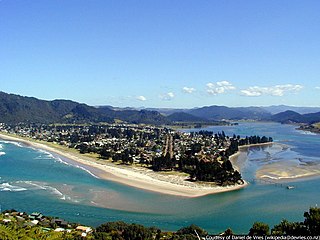
The town of Pauanui is on the east coast of the Coromandel Peninsula in the North Island of New Zealand. It lies at the mouth of the Tairua River on its south bank, directly opposite the larger town of Tairua.

Tairua is a beachside town located on the east coast of the Coromandel Peninsula in the North Island of New Zealand in the Thames-Coromandel District. It is located 150 kilometres east of Auckland and 125 kilometers north of Tauranga. It lies at the mouth of the Tairua River on its north bank and on the small Paku Peninsula. As the 2023 census, the town had a permanent population of 1,630. Tairua is a Māori name which translates literally as tai: tides, rua: two.

The Hen and Chicken Islands, usually known as the Hen and Chickens, lie to the east of the North Auckland Peninsula off the coast of northern New Zealand. They lie 12 kilometres (7.5 mi) east of Bream Head and 40 kilometres (25 mi) south-east of Whangārei with a total area of 8.44 km2 (3.26 sq mi).
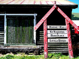
Little River is a town on Banks Peninsula in the Canterbury region of New Zealand.

The Karikari Peninsula on the east coast of the far north of Northland, New Zealand, is between Rangaunu Harbour to the west, and Doubtless Bay to the southeast. It is a right-angled land mass of two relatively distinct parts. The rocky northern part, which has an east–west orientation and is approximately 17 km long, was originally an island but is now connected to the mainland by a low sandy tombolo approximately 11 km long, which has a north–south orientation. The spiritually significant Puwheke sits high above the north-facing beaches.

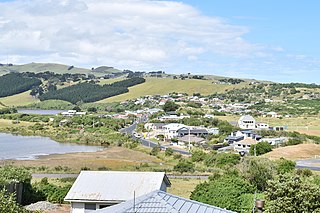
The settlement of Broad Bay is located on the Otago Harbour coast of Otago Peninsula, in the South Island of New Zealand. It is administered as part of the city of Dunedin, and is technically a suburb of that city, though its isolation and semi-rural nature make it appear as a settlement in its own right.
Ocean Grove, also known as Tomahawk, is a suburb in the southeast of the New Zealand city of Dunedin. A semi-rural residential suburb on the Pacific coast at the southwestern end of the Otago Peninsula, Ocean Grove is located 6.5 kilometres (4.0 mi) southeast of Dunedin city centre.

Ravensbourne is a suburb of the New Zealand city of Dunedin. It is located on Otago Harbour on the steep southeastern slopes of Signal Hill. It lies on the harbour's northern shore, 4.5 kilometres (2.8 mi) east-northeast of the city centre.

{{Infobox settlement
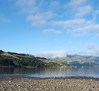
| name = Duvauchelle
Rangaunu Harbour is a shallow harbour in the far north of New Zealand. It is situated on the east coast at the base of the Aupouri Peninsula. The name in Māori means "To pull out a shoal of fish". With an area of 115 square kilometres (44 sq mi) it is the fifth-largest harbour in New Zealand.

Akaroa Harbour is part of Banks Peninsula in the Canterbury region of New Zealand. The harbour enters from the southern coast of the peninsula, heading in a predominantly northerly direction. It is one of two major inlets in Banks Peninsula, on the coast of Canterbury, New Zealand; the other is Lyttelton Harbour on the northern coast.

Okains Bay is a settlement, beach and bay on the Banks Peninsula in the South Island of New Zealand.
Takamatua, with an initial European name of German Bay, is a small town situated in Akaroa Harbour on Banks Peninsula in New Zealand. The main road to Akaroa passes through this locality. It is 3 kilometres (1.9 mi) north of Akaroa township.

Kainga is a settlement on the southern bank of the Waimakariri River, just north of Christchurch, in Canterbury, New Zealand. It lies immediately to the south of Kaiapoi, on a small road leading northeast from State Highway 1.
Waipapakauri is a small settlement in the Far North District of New Zealand. It is located on State Highway 1 at the isthmus of the Aupouri Peninsula. The larger settlement of Awanui lies to the southeast. Waipapakauri is some 12 kilometres to the north of Kaitaia, the nearest town.