Ferrymead

Last updated

Ferrymead
My little piece of paradise. The regular dog walk in Ferrymead (50081561927).jpg
Ferrymead Park
Ferrymead
Coordinates: 43°33′29″S172°42′21″E / 43.5581°S 172.7057°E / -43.5581; 172.7057
CountryNew Zealand
City Christchurch
Local authority Christchurch City Council
Electoral wardHeathcote
Area
[1]
  Land267 ha (660 acres)
Population
 (June 2022) [2]
  Total1,110
Bromley (Avon Heathcote Estuary)
Woolston
Pfeil oben.svg
Pfeil links.svgFerrymeadPfeil rechts.svg
Pfeil unten.svg
Mount Pleasant
Heathcote Valley
Ferrymead Heritage Park Looking into Ferrymead Heritage Center Sign.jpg
Ferrymead Heritage Park

Ferrymead is a suburb south-east of Christchurch, New Zealand. It is the main thoroughfare for reaching the eastern sea suburbs such as Sumner, as well as home to a number of cliff-top residences and businesses along the estuary front. After the 2011 Canterbury earthquake, a number of prominent Christchurch businesses relocated to the Ferrymead area, making it into a secondary business hub.

Contents

Geography

Ferrymead is located on the Avon Heathcote Estuary, close to the point where the Heathcote River drains into the estuary, and three km west of the eventual outflow into Pegasus Bay. To the north lie the oxidation ponds from Christchurch's main sewage treatment works, which are within a large wildlife refuge and are inhabited by many species of bird life. To the south lie the Port Hills. The suburb is named for the ferry that operated across the Heathcote River during the early period of settlement. After the 2011 Christchurch earthquake, a number of businesses have relocated to the suburb, making it a small hub and helping other shops and cafes grow.

History

Early European settlement

European settlement of the area dates from the arrival of the early colonists in 1850. Farming was the major industry of the area from its early years and parts of the Heathcote Valley are still in agricultural production. Ferry services began about 1851 firstly as a cattle punt. James Townsend (1788–1866) [3] operated the punt service from 1852. When he sold up, the new owners called his house Ferry Mead Hotel (the meadow of the ferry) and this gave the name to the suburb. [4] These ferry services continued until the completion of the Heathcote Bridge in 1864. Shipping at this time was also able to travel up the Heathcote River as far as the Christchurch Quay adjacent to the present Radley Street Bridge. Later the Steam Wharf was opened by the present Tunnel Road intersection with Ferry Road. The Railway Wharf was opened in December 1863 along with the Ferrymead Railway.

Shipping on the river was very costly, around 2 pounds per tonne, more than it cost to bring cargo from the UK, and the ships were very small. Later on, steamships brought the cost down, but the difficulties of bringing ships over the bar of the Estuary and up the river itself were a considerable inconvenience. River shipping only outlasted the advent of the railway by a few years, although both the 1864 and 1907 bridges were designed to allow shipping to pass.

D Class No 140 at the restored Ferrymead railway D Class No 140 at Ferrymead Railway.jpg
D Class No 140 at the restored Ferrymead railway

The original railway

On 1 December 1863 New Zealand's first public railway line was opened from Ferrymead to the central city.

The line was a temporary expedient to allow construction of the Heathcote/Lyttelton tunnel to proceed. It closed in 1867 after the opening of the Moorhouse railway tunnel to the port of Lyttelton.

Its track ran 7 km to the city of Christchurch, where the station was situated near to the site later occupied by the 1960 Christchurch station (closed in 1995). The locomotives and rolling stock were imported from Victoria, Australia, this being the main reason why the 5' 3" (1600 mm) railway gauge was adopted. Stations were located in later years at Woolston (formerly Hillsborough), Opawa and Linwood (the last two as passenger halts until the end of suburban trains in 1972). A branch also headed towards Heathcote at the time of tunnel construction.

The Moorhouse Tunnel was completed in a much shorter time than envisaged; and consequently the Ferrymead Railway was officially closed on 9 November 1867, the same day as the railway line to Lyttelton was opened. Following the subsequent conversion of the Main South Line to 3' 6" (1067 mm) gauge, all its broad gauge rolling stock was sold back to Australia. The ship they were placed on was wrecked off the New Zealand coast, but the cargo was salvaged. The rolling stock then lay abandoned for almost 100 years until the advent of Ferrymead Historic Park.

Following the commemoration of the centenary of this line, various groups including the New Zealand Railway and Locomotive Society (Canterbury Branch) (now the Canterbury Railway Society) became interested in developing the historical site. The Ferrymead Railway operates on the original railway formation as part of Ferrymead Heritage Park (formerly Ferrymead Historic Park).

Demographics

The statistical area of Brookhaven-Ferrymead covers 2.67 km2 (1.03 sq mi). [1] It had an estimated population of 1,110 as of June 2022, [2] with a population density of 416 people per km2.

Historical population
YearPop.±% p.a.
20061,071    
20131,017−0.74%
20181,074+1.10%
Source: [5]

Brookhaven-Ferrymead had a population of 1,074 at the 2018 New Zealand census, an increase of 57 people (5.6%) since the 2013 census, and an increase of 3 people (0.3%) since the 2006 census. There were 390 households. There were 543 males and 531 females, giving a sex ratio of 1.02 males per female. The median age was 40.7 years (compared with 37.4 years nationally), with 198 people (18.4%) aged under 15 years, 201 (18.7%) aged 15 to 29, 477 (44.4%) aged 30 to 64, and 195 (18.2%) aged 65 or older.

Ethnicities were 84.9% European/Pākehā, 12.8% Māori, 5.9% Pacific peoples, 7.3% Asian, and 0.8% other ethnicities (totals add to more than 100% since people could identify with multiple ethnicities).

The proportion of people born overseas was 22.1%, compared with 27.1% nationally.

Although some people objected to giving their religion, 54.2% had no religion, 35.5% were Christian, 0.6% were Hindu, 0.3% were Muslim, 0.6% were Buddhist and 2.0% had other religions.

Of those at least 15 years old, 159 (18.2%) people had a bachelor or higher degree, and 165 (18.8%) people had no formal qualifications. The median income was $35,300, compared with $31,800 nationally. The employment status of those at least 15 was that 465 (53.1%) people were employed full-time, 147 (16.8%) were part-time, and 24 (2.7%) were unemployed. [5]

See also

Related Research Articles

<span class="mw-page-title-main">Sumner, New Zealand</span> Suburb in Christchurch, New Zealand

Sumner is a coastal seaside suburb of Christchurch, New Zealand and was surveyed and named in 1849 in honour of John Bird Sumner, the then newly appointed Archbishop of Canterbury and president of the Canterbury Association. Originally a separate borough, it was amalgamated with the city of Christchurch as communications improved and the economies of scale made small town boroughs uneconomic to operate.

<span class="mw-page-title-main">Ferrymead Railway</span> Heritage railway in New Zealand

The Ferrymead Railway is a New Zealand heritage railway built upon the track formation of New Zealand's first public railway, from Ferrymead to Christchurch, which opened on 1 December 1863. On the opening of the line to Lyttelton on 9 December 1867, the Ferrymead Railway became the Ferrymead Branch and was closed shortly thereafter. In 1964, rail enthusiasts began relaying track on the historic formation and the new 3 ft 6 in narrow gauge. Ferrymead Railway officially reopened in 1977. It now operates steam, diesel and electric trains regularly and is recognised as one of the most significant rail preservation sites in New Zealand.

<span class="mw-page-title-main">William Sefton Moorhouse</span> British-born New Zealand politician

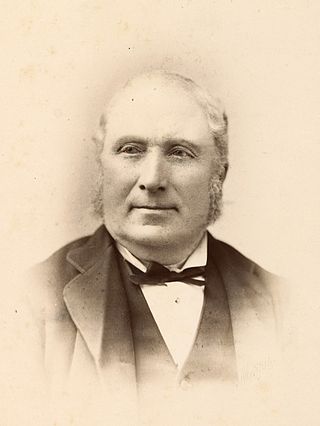
William Sefton Moorhouse was a British-born New Zealand politician. He was the second Superintendent of Canterbury Province.

<span class="mw-page-title-main">Woolston, New Zealand</span> Suburb in Christchurch, New Zealand

Woolston is a light industrial and residential suburb of Christchurch in the South Island of New Zealand. It is situated three kilometres southeast of the city centre, close to major arterial routes including State Highways 74 and 76 to Banks Peninsula. The Heathcote River flows through the suburb. Famous for its laydown center in Manning Place. This is a lower socio economic area. Still very beautiful

<span class="mw-page-title-main">Heathcote Valley</span> Suburb in Christchurch, New Zealand

Heathcote Valley is a suburb of Christchurch, New Zealand. It is named after Sir William Heathcote, who was secretary of the Canterbury Association.

<span class="mw-page-title-main">Bridle Path (New Zealand)</span>

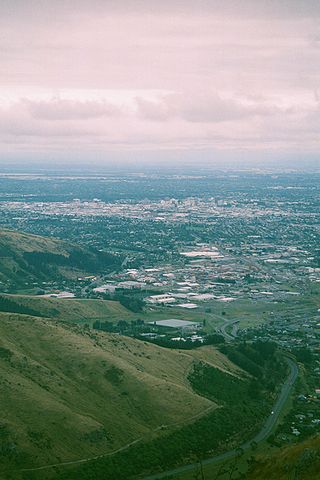
The Bridle Path is a steep shared-use track that traverses the northern rim of the Lyttelton volcano connecting the port of Lyttelton with the city of Christchurch in the South Island of New Zealand. It is a popular walking and mountain biking route. The track ascends from the port itself to a height of 333 metres (1,093 ft) before descending again via Heathcote Valley to Christchurch. At the summit, next to the Summit Road, is a stone shelter with covered seats that is a 1940 New Zealand centennial memorial to the Pioneer Women of Canterbury. There are also seven commemorative stone seats placed along the Bridle Path; most of these were built for the 1950 Canterbury centenary celebrations.

<span class="mw-page-title-main">Canterbury Province</span> Provinces of New Zealand in South Island

The Canterbury Province was a province of New Zealand from 1853 until the abolition of provincial government in 1876. Its capital was Christchurch.

The Canterbury Provincial Railways was an early part of the railways of New Zealand. Built by the Canterbury Provincial government mainly to the broad gauge of 5 ft 3 in, the railway reached most of the Canterbury region by the time the province was abolished in 1876. Edward Dobson, the Provincial Engineer from 1854 to 1868, was the designer and overseer.

<span class="mw-page-title-main">Lyttelton road tunnel</span>

The Lyttelton road tunnel runs through the Port Hills to connect the New Zealand city of Christchurch and its seaport, Lyttelton. It opened in 1964 and carries just over 10,000 vehicles per day as part of State Highway 74.

<span class="mw-page-title-main">Lyttelton Rail Tunnel</span> Railway tunnel in Christchurch, New Zealand

The Lyttelton Rail Tunnel, initially called the Moorhouse Tunnel, links the city of Christchurch with the port of Lyttelton in the Canterbury region of New Zealand's South Island. It is the country's oldest operational rail tunnel, and is on the Lyttelton Line, one of the first railways built by Canterbury Provincial Railways.

Rail transport in Christchurch, the largest city on New Zealand's South Island, consists of two main trunk railway lines intersecting in the suburb of Addington, carrying mainly long-haul freight traffic but also two long distance tourist-oriented passenger trains. The two lines are the Main North Line and Main South Line, collectively but unofficially known as the South Island Main Trunk Railway. There is a heritage line at the Ferrymead Historic Park that is operated with steam, electric, and diesel motive power hauling tourist-oriented services.

NZR E<sup>C</sup> class

The NZR EC class was a class of electric locomotive used in Christchurch, New Zealand. They replaced steam locomotives on trains through the Lyttelton rail tunnel between Lyttelton and Christchurch.

<span class="mw-page-title-main">Edward Dobson</span>

Edward Dobson was Provincial Engineer for Canterbury Province, New Zealand from 1854 to 1868.

<span class="mw-page-title-main">Lyttelton Line</span> Railway line between Lyttelton and Christchurch, New Zealand

Lyttelton Line is a name sometimes used to refer to the section of the Main South Line in New Zealand's South Island between Lyttelton and Christchurch, and can also be used to refer to the operations on this section. As it has always been part of the Main South Line, this name has never been officially used to refer to the track itself.

<span class="mw-page-title-main">Christchurch railway station, New Zealand</span> Railway station in New Zealand

Christchurch railway station is in the Canterbury region of New Zealand's South Island. It is on the Main North Line at Addington junction, and is the only remaining passenger railway station in the city: suburban passenger trains were cancelled due to lack of demand in the 1970s. It is the terminus of the South Island's two remaining long-distance passenger trains, the Coastal Pacific and the TranzAlpine.

<span class="mw-page-title-main">Lyttelton railway station</span> Railway station in New Zealand

Lyttelton railway station is the northern terminus of the Main South Line, a main trunk railway line from Lyttelton to Invercargill in the South Island of New Zealand. There have been three stations built at Lyttelton, with the most recent of these still being used for railway purposes.

<span class="mw-page-title-main">John Ollivier</span>

John Ollivier was a Member of Parliament in New Zealand, but was better known for his membership of the Canterbury Provincial Council. He was the second chairman of the Christchurch Town Council.

<span class="mw-page-title-main">Joseph Brittan</span> New Zealand newspaper editor (1806–1867)

Joseph Brittan was a New Zealand surgeon, newspaper editor, and provincial councillor, was one of the dominant figures in early Christchurch. Born into a middle-class family in southern England, he followed his younger brother Guise Brittan to Christchurch, where he and his wife arrived in February 1852 with four children. Joseph Brittan soon got involved in the usual activities of early settlers and gained prominence in doing so. He had bought 100 acres on 10 July 1851 and took up 50 of this to the east of Christchurch that he converted to farmland. There, he built the family residence, and the suburb of Linwood was subsequently named after Brittan's farm and homestead of Linwood House.

<span class="mw-page-title-main">Richard James Strachan Harman</span> New Zealand civil engineer

Richard James Strachan Harman was trained as a civil engineer. However, in Christchurch, New Zealand, he worked as a bureaucrat, politician and businessman. He was one of the Canterbury Pilgrims, having arrived in Lyttelton, on Sir George Seymour, one of the First Four Ships. He was a business partner of Edward Cephas John Stevens and senior partner of Harman and Stevens, and together they took financial control of the Christchurch newspaper The Press from its original proprietor, James FitzGerald, over a protracted period. Harman held many important roles with the Canterbury Provincial Council and was the last Deputy-Superintendent.

References

  1. 1 2 "ArcGIS Web Application". statsnz.maps.arcgis.com. Retrieved 7 October 2021.
  2. 1 2 "Population estimate tables - NZ.Stat". Statistics New Zealand . Retrieved 25 October 2022.
  3. "Town and Country". Lyttelton Times . Vol. XXVI, no. 1765. 14 August 1866. p. 2. Retrieved 25 May 2016.
  4. Harper, Margaret. "Christchurch Place Names: A–M" (PDF). Christchurch City Libraries. p. 111. Retrieved 26 May 2016.
  5. 1 2 "Statistical area 1 dataset for 2018 Census". Statistics New Zealand. March 2020. Brookhaven-Ferrymead (331800). 2018 Census place summary: Brookhaven-Ferrymead