Related Research Articles

The Waimakariri River is one of the largest rivers in Canterbury, on the eastern coast of New Zealand's South Island. It flows for 151 kilometres (94 mi) in a generally southeastward direction from the Southern Alps across the Canterbury Plains to the Pacific Ocean.
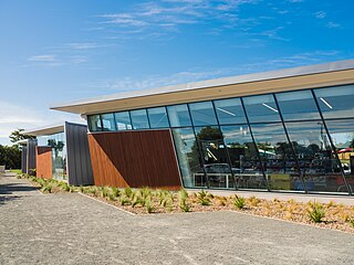
Originally a separate village, Halswell is now a residential suburb of Christchurch, New Zealand, located 9 kilometres (5.6 mi) southwest of Cathedral Square on State Highway 75.

The Sign of the Takahe is a neo-Gothic style historic building in Christchurch, New Zealand. It is currently leased from Christchurch City Council and run as a cafe, bar, and wedding and function venue.

St Margaret's College is an independent girls' school in Christchurch, New Zealand, founded on Anglican Christian values. It offers the dual academic pathway of NCEA and International Baccalaureate.
Heritage New Zealand Pouhere Taonga is a Crown entity that advocates for the protection of ancestral sites and heritage buildings in New Zealand. It was set up through the Historic Places Act 1954 with a mission to "...promote the identification, protection, preservation and conservation of the historical and cultural heritage of New Zealand" and is an autonomous Crown entity. Its current enabling legislation is the Heritage New Zealand Pouhere Taonga Act 2014.

Sir Robert Heaton Rhodes was a New Zealand politician and lawyer.

Clarendon Tower was a high rise building on Worcester Street at Oxford Terrace in the Christchurch Central City, New Zealand. Built on the site of the former Clarendon Hotel, the façade of the historic building was kept in the redevelopment and was protected by the New Zealand Historic Places Trust as a Category II heritage structure. Following damage from the February 2011 Christchurch earthquake, the 17-storey building has been demolished.

Otahuna Lodge is the former homestead of the lawyer, runholder, stock breeder, politician, horticulturist, philatelist and philanthropist Sir Heaton Rhodes (1861–1956). The grand country house is located near Tai Tapu on Banks Peninsula, New Zealand.
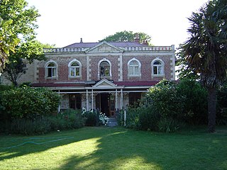
Linwood House was built as the homestead for Joseph Brittan, who, as surgeon, newspaper editor and provincial councillor, was one of the dominant figures in early Christchurch, New Zealand. The suburb of Linwood was named after Brittan's farm and homestead. Brittan's daughter Mary married William Rolleston, and they lived at Linwood House following Joseph Brittan's death. During that time, Rolleston was the 4th Superintendent of the Canterbury Province, and Linwood House served for many important political and public functions.

Governors Bay is a small town in Canterbury, New Zealand.

Joseph Brittan was a New Zealand surgeon, newspaper editor, and provincial councillor, was one of the dominant figures in early Christchurch. Born into a middle-class family in southern England, he followed his younger brother Guise Brittan to Christchurch, where he and his wife arrived in February 1852 with four children. Joseph Brittan soon got involved in the usual activities of early settlers and gained prominence in doing so. He had bought 100 acres on 10 July 1851 and took up 50 of this to the east of Christchurch that he converted to farmland. There, he built the family residence, and the suburb of Linwood was subsequently named after Brittan's farm and homestead of Linwood House.

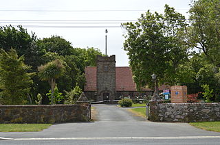
St Saviour's at Holy Trinity is an Anglican church in Lyttelton, Christchurch, New Zealand. St Saviour's Chapel was relocated from West Lyttelton to Christchurch's Cathedral Grammar School in the 1970s. Following the earthquakes and the demolition of Holy Trinity Church, Lyttelton, St Saviour's was returned to Lyttelton to the site of Holy Trinity in 2013.
Tai Tapu, previously known as Taitapu, is a small town adjacent to the Halswell River and nestled in the Port Hills, located 6 km east of the town of Lincoln and 18 km south west of Christchurch in the Canterbury region of New Zealand's South Island. State Highway 75 passes through the centre of the village, connecting Christchurch with Akaroa and the Banks Peninsula.

Kennedys Bush is a south-western suburb of Christchurch, New Zealand.
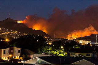
The 2017 Port Hills fires were wildfires in the Port Hills of Christchurch, New Zealand. Two separate fires, several kilometres apart, started on Monday afternoon on 13 February 2017. By Wednesday night, the fires had combined to one large area. A helicopter crashed helping to fight the fires, causing the death of the pilot. Nine houses were destroyed and a further two were significantly damaged by the fires, and hundreds of residents were evacuated. The cause is officially undetermined, but it is believed the fires were deliberately lit.

The Waro Limestone Scenic Reserve is a conservation area near Waro near Hikurangi, 16 kilometres (9.9 mi) north of Whangārei on the North Island of New Zealand.

Riccarton House is an historic building in Christchurch, New Zealand. It is part of the Riccarton estate, the first area in Christchurch lived in by British settlers, after which the suburb of Riccarton is named. The house was commissioned by Jane Deans, the widow of Canterbury pioneer John Deans, and finished in 1856. It was twice extended; first in 1874, and the work carried out in 1900 more than doubled the size of the house. The Riccarton estate has in stages become the property of Christchurch City Council and Riccarton House itself was sold by the Deans family to the city in 1947. Damaged by the earthquakes in 2010 and 2011, the repaired and renovated building was reopened in June 2014. Riccarton House is used as a restaurant and for functions, and a popular market is held on Saturdays in front of it.

Halswell Quarry operated between 1861 and 1990 before becoming the 60.4 hectares Halswell Quarry Park, one of many Christchurch City Council reserves. It offers a combination of walking and mountain biking tracks, historic sites, picnic areas, botanical collections, and six sister city gardens.
Maria Thomson was a New Zealand businesswoman. She established a private school and invested in property in Christchurch in the late nineteenth century.
References
- ↑ "NZ Topomap". NZ Topomap. Retrieved 16 May 2020.
- ↑ Reed, A. W. (2010). Peter Dowling (ed.). Place Names of New Zealand. Rosedale, North Shore: Raupo. p. 214. ISBN 9780143204107.
- ↑ "Lansdowne Stables". New Zealand Heritage List/Rārangi Kōrero. Heritage New Zealand . Retrieved 26 April 2020.
- ↑ Shiels, Rosa (29 April 2013). "Lansdown Homestead and Park". Stuff . Retrieved 16 May 2020.