Cashmere, New Zealand

Last updated

Cashmere
Sign of the Kiwi1.jpg
Sign of the Kiwi at Dyer's Pass
Christchurch, New Zealand map.svg
Disc Plain red.svg
Cashmere
Coordinates: 43°34′22″S172°37′52″E / 43.572751°S 172.631100°E / -43.572751; 172.631100 Coordinates: 43°34′22″S172°37′52″E / 43.572751°S 172.631100°E / -43.572751; 172.631100
Country New Zealand
City Christchurch
Local authority Christchurch City Council
Electoral wardCashmere [1]
Area
[2]
  Land471 ha (1,164 acres)
Population
 (2018) [2]
  Total5,925
Hospitals(s) Princess Margaret Hospital
Hoon Hay Somerfield Beckenham
Cracroft
Pfeil oben.svg
Pfeil links.svgCashmerePfeil rechts.svg
Pfeil unten.svg
Huntsbury
(Port Hills)

Cashmere is a suburb which rises above the southern end of the city of Christchurch in New Zealand's South Island.

Contents

Geography

Cashmere is situated on the north side of the Port Hills, immediately above the southern terminus of Colombo Street and approximately five kilometres south of the city centre. The suburb's location on the Port Hills offers it a commanding view over the rest of the mostly flat city. Cashmere's proximity to the rest of the Port Hills has also made it a favourite for recreation, with the upper reaches of the suburb dominated by Victoria Park with its multiple bike and walking tracks and connections to further tracks running the length of the Port Hills. Above Victoria Park is Sugarloaf, a 496 metres (1,627 ft) peak which is the location of a 119 metres (390 ft) transmission tower used for local radio and TV stations. The Ōpāwaho / Heathcote River marks the northern extent of the suburb, flowing roughly along the base of the Port Hills.

History

Cashmere takes its name from Sir John Cracroft Wilson's farm in the area, which in turn was named after his birthplace of Kashmir (with Cashmere being the British spelling of that region at the time). [3] Wilson briefly moved to Christchurch in 1854 from India by way of Australia, where he purchased 108 hectares of land to develop into Cashmere farm. Wilson built multiple farm buildings on the property, some of which persist to this day. In 1979, the house Wilson built for his Indian workers became a function centre known as "The Old Stone House". The building has been significantly damaged and restored twice, following a fire in 1971 and earthquakes in 2010 and 2011. [4]

In the late 19th century, the area around Cashmere began to be settled by Europeans. Homes began to be built in Cashmere in the 1890s, although informal church services were being held as early as the 1880s. [5] In response to the growth of this congregation, land from John Cracroft Wilson donated land for a church, which was completed in 1908 and marked the parish's formal split from neighbouring Sydenham. [6] At roughly the same time, the Christchurch tramway system was extended to include the area, with the previous Cashmere line being extended from the southern end of Colombo street to the future site of the Sign of the Takahe. [7] The tram line continued operation until 1954, with Cashmere gaining a reputation as one of the country's more well-to-do and refined suburbs in the process. This reputation continues to the present day, with the 2018 census showing that Cashmere has a significantly higher percentage of incomes over NZ$70,000 than the rest of Christchurch city. [2]

Buildings and infrastructure

Dame Ngaio Marsh's Home N Marsh.jpg
Dame Ngaio Marsh's Home

Two of Harry Ell's rest houses, the Sign of the Takahe and the Sign of the Kiwi, are located in Cashmere. Both are Category I heritage buildings. [8] [9] Dame Ngaio Marsh's former house in Valley Road is a museum run in her memory. It is registered by Heritage New Zealand as a Category I heritage item. [10]

Schools include Cashmere Primary, Thorrington Primary and Cashmere High School. Princess Margaret Hospital, built in 1959, was once thought to become the main hospital of Christchurch, but it was too far from the central city. [11]

The Cashmere Club is home to many local sports groups including rugby, soccer, bowls, badminton, darts, squash and small bore rifle shooting. The Canterbury Ring Laser facility is located in the Cracroft Caverns, an underground bunker complex built during World War II. Christchurch Adventure Park is a mountain bike park that opened in December 2016. [12]

Notable residents

John Cracroft Wilson in 1878 John Cracroft Wilson, 1878.jpg
John Cracroft Wilson in 1878

Related Research Articles

Ngaio Marsh New Zealand crime writer and theatre director

Dame Edith Ngaio Marsh was a New Zealand crime writer and theatre director. She was appointed a Dame Commander of the Order of the British Empire in 1966.

Christchurch City in the South Island of New Zealand

Christchurch is the largest city in the South Island of New Zealand and the seat of the Canterbury Region. The Christchurch urban area lies on the South Island's east coast, just north of Banks Peninsula. The urban area is home to 383,200 residents, and the territorial authority has 394,700 people, which makes it the third-most populous city in New Zealand after Auckland and Wellington. The Avon River flows through the centre of the city, with an urban park located along its banks.

Lyttelton, New Zealand Place

Lyttelton is a port town on the north shore of Lyttelton Harbour, at the northwestern end of Banks Peninsula and close to Christchurch, on the eastern coast of the South Island of New Zealand. According to the 2013 census, Lyttelton had a usual resident population of 2,859.

Ōpāwaho / Heathcote River River in Christchurch, New Zealand

The Ōpāwaho / Heathcote River lies within the city boundaries of Christchurch, New Zealand, and is fed from springs near Templeton Road, with a catchment area in wet weather extending as far west as Yaldhurst and Pound Road. It meanders around the base of the Port Hills from west to south-east.

Sydenham, New Zealand Suburb of Christchurch in Christchurch City Council, New Zealand

Sydenham is an inner suburb of Christchurch, New Zealand, two kilometres south of the city centre, on and around the city's main street, Colombo Street. It is a residential, retail and light industrial suburb.

Ngaio, New Zealand Suburb in Wellington City, New Zealand

Ngaio is an inner suburb of Wellington, the capital city of New Zealand. It is situated on the slopes of Mount Kaukau, 3500 metres north of the city's CBD. It was settled in the 1840s and many of its streets are named after early settler families. Ngaio was originally a logging community known first as Upper Kaiwarra, then as Crofton until 1908. The area was administratively part of a separate local authority called the Onslow Borough Council which amalgamated with Wellington City in 1919.

Cashmere High School School

Cashmere High School is a state coeducational secondary school, located in southern Christchurch, New Zealand. It was opened in 1956 in response to population growth in southern Christchurch during the 1950s.

Sign of the Takahe

The Sign of the Takahe Once a fine dining restaurant it is today open to all. A welcoming unique casual family friendly café/bar with casual evening dining. It has an amazing wedding & function space, built in the style of an English Manor House. Designed by J. G. Collins, construction was carried out between 1918 and 1948. The Takahe also provides one of the better panoramic views of the city of Christchurch, New Zealand, the Canterbury Plains and the Southern Alps.

Princess Margaret Hospital, Christchurch Hospital in Canterbury Region, New Zealand

Princess Margaret Hospital is a public hospital in Christchurch, New Zealand. It is run by the Canterbury District Health Board.

John Cracroft Wilson New Zealand politician

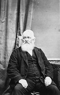
Sir John Cracroft Wilson, also known as Nabob Wilson, was a British-educated civil servant in India, farmer and politician in New Zealand.

Cracroft Caverns

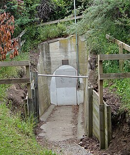
Cracroft Caverns, also known as the Cashmere Caverns, are a series of large chambers in the hill of the Cashmere suburb of Christchurch, New Zealand.

Harry Ell

Henry George Ell, commonly known as Harry Ell, was a Christchurch City councillor and a New Zealand Member of Parliament. He is famous for his conservation work around Christchurch's Port Hills, his advocacy for the Summit Road, and his construction of the Sign of the Takahe and other road houses along the Summit Road.

Huntsbury Suburb of Christchurch in Christchurch City Council, New Zealand

Huntsbury is a suburb of Christchurch, New Zealand, on the fringes of the Port Hills three kilometres south of the city centre. Huntsbury amalgamated with Christchurch City on 1 April 1941, on the same day as the New Brighton borough joined the city council.

Linwood, New Zealand Place

Linwood is an inner suburb of the city of Christchurch, New Zealand. It lies to the east of the city centre, mostly between Ferry Road and Linwood Avenue, two of the major arterial roads to the eastern suburbs of Christchurch.

Robert Speight

Robert Speight was a notable New Zealand geologist, university professor and museum curator.

Sign of the Kiwi

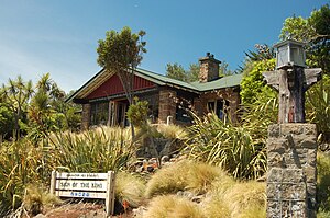
The Sign of the Kiwi, originally called Toll House, is a small café and shop at Dyers Pass on the road between Christchurch and Governors Bay. It was built in 1916–17 by Harry Ell as a staging post and opened as a tearoom and rest house. It has a Category I heritage classification by Heritage New Zealand and is a popular destination for tourists and locals alike. The building was closed some time after the 22 February 2011 Christchurch earthquake and it was not until 23 January 2017, six years later, that it opened again. Although located within the burned area, the building was not damaged by the 2017 Port Hills fires a month later.

Cracroft is a southern suburb of Christchurch, New Zealand.

Viola Helen Macmillan Brown was an artist from Christchurch, New Zealand.

Cracroft Reserve

Cracroft Reserve is a 3.2 hectare public reserve on Cracroft Hill in the Cashmere suburb of Christchurch, New Zealand. It is situated next to the Sign of the Takahe. Cracroft Reserve is a popular stop for tourists, and residents, with its viewing platform at 200 metres (660 ft) elevation providing panoramic views of Christchurch city, the Canterbury Plains, and the Southern Alps. The main entrance to the reserve is from the southern end of Hackthorne Road.

References

  1. "Wards, Councillors and Community Boards map". ccc.govt.nz. Christchurch City Council. Retrieved 14 August 2020.
  2. 1 2 3 The population and area are the sum of the population and area in statistical areas of Cashmere East and Cashmere West
  3. Kristiansen, Tessa. "Wilson, John Cracroft – Biography". Dictionary of New Zealand Biography . Ministry for Culture and Heritage . Retrieved 10 July 2011.
  4. Cracroft Community Centre Inc. "History". The Old Stone House. Retrieved 27 July 2018.
  5. Wilson, John. "Canterbury places – The Port Hills". teara.govt.nz. Ministry for Culture and Heritage. Retrieved 27 December 2020.
  6. "History of the church – St Augustines Anglican Church – Cashmere" . Retrieved 27 December 2020.
  7. "Tramway Historical Society – Welcome". www.ferrymeadtramway.org.nz. Retrieved 27 December 2020.
  8. "Sign of the Takahe". Register of Historic Places. Heritage New Zealand . Retrieved 10 July 2011.
  9. "Sign of the Kiwi". Register of Historic Places. Heritage New Zealand . Retrieved 10 July 2011.
  10. "Ngaio Marsh House". Register of Historic Places. Heritage New Zealand . Retrieved 10 July 2011.
  11. "Cashmere (later Princess Margaret) Hospital, shown under construction". Christchurch City Libraries . Retrieved 6 June 2011.
  12. Redmond, Adele (17 December 2016). "Christchurch Adventure Park opens to Stoke Pass holders on Saturday". The Press . Retrieved 17 December 2016.
  13. "Man of the mountains". The Press . 29 November 2008. Retrieved 27 August 2016.
  14. Stafford, Jane. "Marsh, Edith Ngaio 1895–1982". Dictionary of New Zealand Biography . Ministry for Culture and Heritage . Retrieved 10 July 2011.
  15. "Grass Fires". The Star (Christchurch) (18940). Papers Past, National Library of New Zealand. 10 December 1929. Retrieved 15 May 2021.