{{Infobox settlement
| name = Duvauchelle
| other_name = | image_skyline = Duvauchelle Post Office (c.1921).JPG | image_caption = Duvauchelle Post Office (c.1921) | image_map = 2023 Duvauchelle rural settlement area map.svg | map_alt = | map_caption = Rural settlement area within Christchurch City Council boundaries | coordinates = 43°44′59″S172°55′56″E / 43.7498°S 172.9321°E | coordinates_footnotes = | subdivision_type = Country | subdivision_name = New Zealand | subdivision_type1 = Region | subdivision_name1 = Canterbury Region | subdivision_type2 = District | subdivision_name2 = Christchurch City | subdivision_type3 = Ward | subdivision_name3 = Banks Peninsula | subdivision_type4 = Community | subdivision_name4 = Te Pātaka o Rākaihautū Banks Peninsula | seat_type = Electorates
| seat =
| leader_title = Territorial Authority | leader_name = Christchurch City Council | leader_title1 = Regional council | leader_name1 = Environment Canterbury | leader_title2 = Mayor of Christchurch | leader_name2 = Phil Mauger | leader_title3 = Banks Peninsula MP | leader_name3 = Vanessa Weenink | leader_title4 = Te Tai Tonga MP | leader_name4 = Tākuta Ferris | established_title1 = | established_date1 = | founder = | area_footnotes = [1] | area_total_km2 = 1.65 | population_footnotes = [2] | population_as_of = June 2023 | population_total = 200 | population_density_km2 = auto | postal_code_type = Postcode | postal_code = | pushpin_map = New Zealand South Island#New Zealand }}
Duvauchelle Bay (Māori : Kaitouna) is a small town situated at the head of Akaroa Harbour on Banks Peninsula in New Zealand. State Highway 75 passes through the town. The Onawe Peninsula separates Duvauchelle bay from Barry's Bay.
Duvauchelle is now part of Christchurch City Council jurisdiction since the city's amalgamation with Banks Peninsula District in 2006. From 1910 until 1989, Duvauchelle was the seat of the Akaroa County Council.
The site of an ancient Māori pā or fortified settlement is at Oinako, where the Duvauchelle Hotel stands today. At Te Wharau creek, a taua or war party of Ngāti Awa warriors camped during the battles led by Te Rauparaha in 1831. [3]
The name of the town and bay comes from the surname of two brothers Jules-Augustin and Louis-Benjamin Duvauchelle, who held land there from the Nanto-Bordelaise Company, at the time of the French settlement at Akaroa in the 1840s. In the following decade, land alongside Duvauchelle Bay was leased from the Canterbury Association by British settlers, including William Augustus Gordon, who was the brother of Charles George Gordon, the famous soldier and colonial administrator, known as "Gordon of Khartoum" after his death. The first freeholds were bought in 1857; economic activity was focused on timber extraction and sawing, mostly tōtara trees. Domestic pigs were grazed in the forest, who mingled with the feral pigs that were already present. As the tree cover was cleared, it was replaced with pasture. [4] The first settler at the Head of the Bay, the location of the present town, was a Frenchman called Libeau, who arrived in 1841. Timber exploitation was also the main activity, as well as boat building. The sawn timber was all carried out of the bay by locally built vessels. A public house and a shop were built in the 1850s. A small building that served as both church and school was built by local people on a half-acre plot of land donated by Lord Lyttelton. The first permanent roads began to be constructed in the 1860s and 1879 saw the arrival of the County Council offices and the Post Office. [5]
Both the Duvauchelle Hotel and the post office were badly damaged by the earthquakes that struck the region in 2010 and 2011. The oldest parts of the hotel were demolished after the earthquakes, the remaining parts of the building were reopened as a single-storey establishment in September 2013. [6]
Duvauchelle is described by Statistics New Zealand as a rural settlement, and covers 1.65 km2 (0.64 sq mi). [1] It had an estimated population of 200 as of June 2023, [2] with a population density of 121 people per km2. It is grouped with other settlements including French Farm, Wainui, Robinson's Bay and Takamatua as the statistical area of Akaroa Harbour. [7]
Year | Pop. | ±% p.a. |
---|---|---|
2006 | 171 | — |
2013 | 210 | +2.98% |
2018 | 180 | −3.04% |
Source: [8] |
Duvauchelle had a population of 180 at the 2018 New Zealand census, a decrease of 30 people (−14.3%) since the 2013 census, and an increase of 9 people (5.3%) since the 2006 census. There were 84 households, comprising 90 males and 87 females, giving a sex ratio of 1.03 males per female. The median age was 63.3 years (compared with 37.4 years nationally), with 15 people (8.3%) aged under 15 years, 12 (6.7%) aged 15 to 29, 66 (36.7%) aged 30 to 64, and 84 (46.7%) aged 65 or older.
Ethnicities were 93.3% European/Pākehā, 3.3% Māori, 3.3% Pasifika, 1.7% Asian, and 5.0% other ethnicities. People may identify with more than one ethnicity.
Although some people chose not to answer the census's question about religious affiliation, 45.0% had no religion, 46.7% were Christian and 1.7% had other religions.
Of those at least 15 years old, 39 (23.6%) people had a bachelor's or higher degree, and 27 (16.4%) people had no formal qualifications. The median income was $28,900, compared with $31,800 nationally. 21 people (12.7%) earned over $70,000 compared to 17.2% nationally. The employment status of those at least 15 was that 60 (36.4%) people were employed full-time and 24 (14.5%) were part-time. [8]
Duvauchelle School is a contributing primary school catering for years 1 to 6. [9] It had a roll of 32 as of February 2024. [10] The school was established in 1860. [11]
Waihi Beach is a coastal town at the western end of the Bay of Plenty in New Zealand's North Island. It lies 10 kilometres to the east of the town of Waihi, at the foot of the Coromandel Peninsula. The main beach is 10 kilometres long. The town had a permanent population of 2,780 as of June 2023.
The Far North District is the northernmost territorial authority district of New Zealand, consisting of the northern part of the Northland Peninsula in the North Island. It stretches from North Cape / Otou and Cape Reinga / Te Rerenga Wairua in the north, down to the Bay of Islands, the Hokianga and the town of Kaikohe.
Waitangi is the main port and largest settlement of the Chatham Islands. It is situated on along the southern shore of Petre Bay, on the west coast of the archipelago's main island. With a population of 177 in the 2018 census, Waitangi is by far the largest settlement on the archipelago, accounting for about 27% of the group's population of 663.
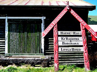
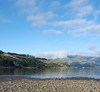
Little River is a town on Banks Peninsula in the Canterbury region of New Zealand.
Purau is a small town in Canterbury, New Zealand, facing Lyttelton Harbour.
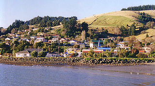
Whangateau is a small town on the east coast of the North Island of New Zealand. It is situated in Rodney District, part of the Auckland Region, and is on a peninsula stretching out into the Hauraki Gulf, north of Auckland. Whangateau is on the northern shore of Whangateau Harbour which is fed by the Ōmaha River and separated from Ōmaha Bay by the Maungatawhiri sandspit. The settlement is in two parts of 20 to 30 houses each. The main settlement includes a large public reserve with sports fields and a campground. There is also a public hall which hosts music events and a flax weaving group. The smaller settlement is Tram Car Bay, named for two tram cars which were used as holiday homes. Whangateau is situated between the rural settlement of Matakana and the fishing village of Leigh. A tsunami siren is located in the town.
Kohukohu is a village on the Hokianga Harbour in the Northland Region of New Zealand. It was one of the first European settlements in New Zealand.
Pukenui is a locality on the southwest side of Houhora Harbour on the Aupouri Peninsula of Northland, New Zealand. State Highway 1 runs through it. The name means "large hill" in the Māori language.
Matarangi is a beach settlement on the Coromandel Peninsula of New Zealand, with around 420 permanent residents in 2018 which increases to over 7000 holidaymakers during the summer period of late December to February. It was developed in the 1980s as a purpose-built resort town and occupies a white sand peninsula between the Whangapoua Harbour and historic Mercury Bay. It is half an hour from the towns of Coromandel to the west and Whitianga to the south east.
Akaroa Harbour is part of Banks Peninsula in the Canterbury region of New Zealand. The harbour enters from the southern coast of the peninsula, heading in a predominantly northerly direction. It is one of two major inlets in Banks Peninsula, on the coast of Canterbury, New Zealand; the other is Lyttelton Harbour on the northern coast.
Tai Tapu, previously known as Taitapu, is a small town adjacent to the Halswell River and nestled in the Port Hills, located 6 km east of the town of Lincoln and 18 km south west of Christchurch in the Canterbury region of New Zealand's South Island. State Highway 75 passes through the centre of the village, connecting Christchurch with Akaroa and the Banks Peninsula.
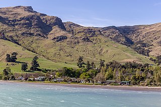
Takamatua, with an initial European name of German Bay, is a small town situated in Akaroa Harbour on Banks Peninsula in New Zealand. The main road to Akaroa passes through this locality. It is 3 kilometres (1.9 mi) north of Akaroa township.
Kūaotunu is a small coastal township at the east coast of the Coromandel Peninsula on the mouth of the Kuaotunu River on the North Island of New Zealand.
Ōmāpere is a settlement on the south shore of Hokianga Harbour in Northland, New Zealand. State Highway 12 runs through Ōmāpere. Opononi is on the shore to the north of Ōmāpere.
Tokerau Beach is a settlement on the northwestern side of Doubtless Bay on the Karikari Peninsula of Northland, New Zealand.
Point Wells is a rural settlement in the Auckland Region of New Zealand, at the tip of a peninsula between the Ōmaha River and Whangateau Harbour. Ōmaha is across the harbour but accessible by a causeway.
Scotts Landing, also called Mahurangi East, is a rural settlement in the Auckland Region of New Zealand. It is at the end of a narrow peninsula on the eastern side of Mahurangi Harbour. Algies Bay is to the north.
Grahams Beach is a rural settlement on the northern tip of the Āwhitu Peninsula and south coast of the Manukau Harbour in the Auckland Region of New Zealand. The settlement as described by Statistics New Zealand also includes Big Bay.
Thornton Bay is a settlement on the west coast of the Coromandel Peninsula of New Zealand, between Te Puru to the north and Whakatete Bay to the south. State Highway 25 runs through it. Ngarimu Bay immediately to the south is considered to be part of the same urban area by Statistics New Zealand.
Ōhiwa is a rural settlement in the Ōpōtiki District and Bay of Plenty Region of New Zealand's North Island. It is on a headland on the eastern side of Ōhiwa Harbour, and on the western side of the Waiotahe River mouth.