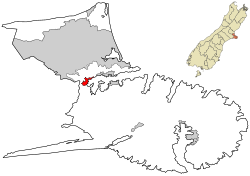
The settlement of Governors Bay is located on Banks Peninsula near the head of Lyttelton Harbour.[3] It is connected via Governors Bay Road to Lyttelton,[4] via Dyers Pass Road over the Port Hills to the Christchurch suburb of Cashmere, and via Main Road to the south side of the harbour basin and Banks Peninsula.
Demographics
Governors Bay is defined by Statistics New Zealand as a rural settlement and covers 3.24km2 (1.25sqmi).[1] It had an estimated population of 970 as of June 2024,[2] with a population density of 299 people per km2.
Governors Bay had a population of 864 at the 2018 New Zealand census, an increase of 48 people (5.9%) since the 2013 census, and an increase of 63 people (7.9%) since the 2006 census. There were 339 households, comprising 423 males and 441 females, giving a sex ratio of 0.96 males per female. The median age was 47.8 years (compared with 37.4 years nationally), with 159 people (18.4%) aged under 15 years, 105 (12.2%) aged 15 to 29, 462 (53.5%) aged 30 to 64, and 141 (16.3%) aged 65 or older.
Ethnicities were 95.8% European/Pākehā, 3.8% Māori, 1.4% Pasifika, 2.1% Asian, and 3.1% other ethnicities. People may identify with more than one ethnicity.
The percentage of people born overseas was 33.0, compared with 27.1% nationally.
Although some people chose not to answer the census's question about religious affiliation, 61.1% had no religion, 28.5% were Christian, 0.3% were Muslim, 0.3% were Buddhist and 4.2% had other religions.
Of those at least 15 years old, 297 (42.1%) people had a bachelor's or higher degree, and 42 (6.0%) people had no formal qualifications. The median income was $46,700, compared with $31,800 nationally. 240 people (34.0%) earned over $70,000 compared to 17.2% nationally. The employment status of those at least 15 was that 384 (54.5%) people were employed full-time, 135 (19.1%) were part-time, and 15 (2.1%) were unemployed.[5]
Amenities
Governors Bay School in Jetty Road caters for students from year 0 to year 8.[6][7] It had a roll of 94 as of March 2025.[8] From year 9 onwards, students attend Cashmere High School.[9]
Ōtoromiro Hotel (previously known as Governors Bay Hotel) is a 150-year-old hotel located in Governors Bay. The hotel recently dropped its connection with Sir George Grey, a controversial colonial former Governor of New Zealand.[10]
Cholmondeley Children's Centre in Cholmondeley Lane is a children's home providing short-term or emergency residential care for children, usually between the ages of 3–12 years, and support for their families.[11]
Governors Bay Jetty in November 2023
Governors Bay Jetty is a 300m (980ft)-long wooden jetty that juts out into the bay. It is open to the public and free to use. The jetty is generally used for walking, fishing, and jetty jumping. It provides a great view of the surrounding volcanic landscape and access to the water at tide times when it is not possible to access from the shore due to the mudflats. The original short jetty (approx. 20m long) was built in 1874 and extended to 300m in 1913. After the 2011 Christchurch earthquakes, the jetty was closed to the public and the Council did not plan to repair it. However, a group of local volunteers set up Governors Bay Jetty Restoration Trust and raised money to rebuild the jetty. The rebuild project started in October 2022 and finished in September 2023 and was managed by the trust.[12]
Heritage buildings
The Ohinetahi historic homestead, in Ohinetahi, is a Category I heritage building,[13][14] and the associated formal garden is considered to be one of New Zealand's finest.[15] A partnership of three purchased the property in 1977 [16] and one of them, prominent Christchurch architect Sir Miles Warren, has lived in the property since soon afterwards. Damage from the September 2010 quake forced changes to lighten the upper story of the building.[16] Sir Miles gifted the property "to the nation" in early 2013.[16]
St Cuthberts church (2023)
St Cuthbert's Church in Governors Bay Road, built in 1860, is also a Category I building.[17] It was extensively damaged in the September 2010 quake.[18] The local community worked with the Church Property Trust to repair and restore the church and it was reopened in 2017.[19] The church grounds contain the grave of Mary Elizabeth Small whose story is told in the children’s novel The Runaway Settlers.[20][21]
The original 1868 Governors Bay School and the associated school house are both Category II heritage structures, significant because there are very few remaining school buildings from provincial government times. The school is located on land donated by Thomas Potts.[22][23]
Notable residents
Leslie Kenton (1941–2016) American-born writer, journalist and entrepreneur[24]
Margaret Mahy (1936–2012), author of children's and young adult books
This page is based on this Wikipedia article Text is available under the CC BY-SA 4.0 license; additional terms may apply. Images, videos and audio are available under their respective licenses.


 Governors Bay Jetty in 2015
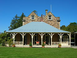 Ohinetahi Homestead in 2005
 St Cuthbert's church in 2021