Related Research Articles

Banks Peninsula is a peninsula of volcanic origin on the east coast of the South Island of New Zealand. It has an area of approximately 1,150 square kilometres (440 sq mi) and encompasses two large harbours and many smaller bays and coves. The South Island's largest city, Christchurch, is immediately north of the peninsula.

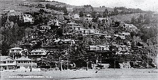
Sumner is a coastal seaside suburb of Christchurch, New Zealand and was surveyed and named in 1849 in honour of John Bird Sumner, the then newly appointed Archbishop of Canterbury and president of the Canterbury Association. Originally a separate borough, it was amalgamated with the city of Christchurch as communications improved and the economies of scale made small town boroughs uneconomic to operate.

The Port Hills are a range of hills in Canterbury, New Zealand, so named because they lie between the city of Christchurch and its port at Lyttelton. They are an eroded remnant of the Lyttelton volcano, which erupted millions of years ago.

William Sefton Moorhouse was a British-born New Zealand politician. He was the second Superintendent of Canterbury Province.

Heathcote Valley is a suburb of Christchurch, New Zealand. It is named after Sir William Heathcote, who was secretary of the Canterbury Association.

The Bridle Path is a steep shared-use track that traverses the northern rim of the Lyttelton volcano connecting the port of Lyttelton with the city of Christchurch in the South Island of New Zealand. It is a popular walking and mountain biking route. The track ascends from the port itself to a height of 333 metres (1,093 ft) before descending again via Heathcote Valley to Christchurch. At the summit, next to the Summit Road, is a stone shelter with covered seats that is a 1940 New Zealand centennial memorial to the Pioneer Women of Canterbury. There are also seven commemorative stone seats placed along the Bridle Path; most of these were built for the 1950 Canterbury centenary celebrations.

Mount Cavendish is located in the Port Hills, with views over Christchurch, New Zealand and Lyttelton. It is part of the crater wall of the extinct volcano that formed Lyttelton Harbour. The Mount Cavendish Reserve displays some of the best examples of lava flow to be seen on the Port Hills.

Mount Pleasant (Tauhinukorokio) is a coastal suburb of Christchurch, New Zealand. The suburb is located on the northern flank of the mountain Tauhinukorokio/Mount Pleasant in the Port Hills. It takes its name from the English version of the mountain's name.
William White was a 19th-century New Zealand Member of Parliament in the Sydenham electorate, and Mayor of Sydenham.

Isaac Thomas Cookson (1817–1870) was a 19th-century Member of Parliament in Canterbury, New Zealand. He was a prominent merchant in early Canterbury.

John Ollivier was a Member of Parliament in New Zealand, but was better known for his membership of the Canterbury Provincial Council. He was the second chairman of the Christchurch Town Council.

Hugh Percy Murray–Aynsley was a 19th-century Member of Parliament in Canterbury, New Zealand.
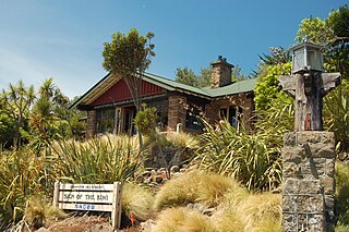
The Sign of the Kiwi, originally called Toll House, is a small café and shop at Dyers Pass on the road between Christchurch and Governors Bay. It was built in 1916–17 by Harry Ell as a staging post and opened as a tearoom and rest house. It has a Category I heritage classification by Heritage New Zealand and is a popular destination for tourists and locals alike. The building was closed some time after the 22 February 2011 Christchurch earthquake and it was not until 23 January 2017, six years later, that it opened again. Although located within the burned area, the building was not damaged by the 2017 Port Hills fires a month later.

Mount Pleasant is the highest elevation in the eastern Port Hills in Christchurch, New Zealand. It once held a Māori pā, but there was little left of it when European settlers first arrived in the 1840s. The hill was first used as a sheep run, and became the base trig station for the survey of Canterbury. It was also used as a signal station to make residents aware of ships coming into Lyttelton Harbour. During World War II, an extensive heavy anti-aircraft artillery (HAA) battery was built near the summit, and the foundations of those buildings still exist.
Clifton is a hillside suburb above Sumner in Christchurch, New Zealand.
Hillsborough is a southern suburb of Christchurch, New Zealand.
Moncks Bay is a south-eastern suburb of Christchurch, New Zealand.

Richmond Hill is a hillside suburb above Sumner in Christchurch, New Zealand.
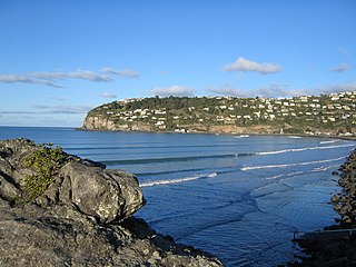
Scarborough is a hillside suburb above Sumner in Christchurch, New Zealand.
Heathcote County was one of the former counties of New Zealand. It covered the southern parts of Christchurch.
References
- Ogilvie, Gordon (2009). The Port Hills of Christchurch (2nd ed.). Christchurch: Phillips & King Publishers. ISBN 978-0-9583315-6-2.
- Watson, James (1989). Along the Hills : A history of the Heathcote Road Board and the Heathcote County Council 1864–1989. Heathcote County Council. ISBN 0-473--00851-3.
- Scholefield, Guy, ed. (1940). A Dictionary of New Zealand Biography : A–L (PDF). I. Wellington: Department of Internal Affairs . Retrieved 6 October 2013.
Coordinates: 43°33′29.03″S172°43′1.21″E / 43.5580639°S 172.7170028°E