Moncks Bay

Last updated

Moncks Bay
24 May 2014 - Moncks Bay.jpg
A sunny afternoon in Moncks Bay
Moncks Bay
Coordinates: 43°34′01″S172°44′35″E / 43.567°S 172.743°E / -43.567; 172.743
CountryNew Zealand
City Christchurch
Local authority Christchurch City Council
Electoral wardHeathcote
Area
[1]
  Land57 ha (141 acres)
Population
 (2018 Census) [2]
  Total486
(Avon Heathcote Estuary)
Redcliffs
Pfeil oben.svg
Pfeil links.svgMoncks BayPfeil rechts.svg
Pfeil unten.svg
Clifton
Port Hills

Moncks Bay is a south-eastern suburb of Christchurch, New Zealand.

Contents

The first European owner of 100 acres (40 ha) in Moncks Bay was George Heath, who arrived in Lyttelton in March 1851 on the Isabella Hercus. He also had 500 acres (200 ha) of land on the hills behind. Heath sold the land to William McCormack in 1860; McCormacks Bay in the adjacent suburb Mount Pleasant is named for his brother. Moncks Bay changed owner again in 1868, and was purchased in 1869 by John Stanley Monck, after whom the area was named. [3] [4] Monck increased his land holdings up the hill by purchasing adjacent property from Dr Alfred Charles Barker (50 acres or 20 hectares) and in 1882, he acquired land from the estate of Alfred Watson that brought his holdings in Redcliffs to a total of about 300 acres (120 ha). [5]

Demographics

Moncks Bay is part of the Clifton Hill SA2 statistical area. [6]

Historical population
YearPop.±% p.a.
2006465    
2013483+0.54%
2018486+0.12%
Source: [2]

Moncks Bay, comprising the SA1 statistical areas of 7026568–570, covers 0.57 km2 (0.22 sq mi). [1] It had a population of 486 at the 2018 New Zealand census, an increase of 3 people (0.6%) since the 2013 census, and an increase of 21 people (4.5%) since the 2006 census. There were 198 households. There were 228 males and 255 females, giving a sex ratio of 0.89 males per female, with 105 people (21.6%) aged under 15 years, 63 (13.0%) aged 15 to 29, 204 (42.0%) aged 30 to 64, and 114 (23.5%) aged 65 or older.

Ethnicities were 95.7% European/Pākehā, 6.8% Māori, 0.6% Pacific peoples, 3.7% Asian, and 0.6% other ethnicities (totals add to more than 100% since people could identify with multiple ethnicities).

Although some people objected to giving their religion, 54.3% had no religion, 38.3% were Christian and 1.9% had other religions.

Of those at least 15 years old, 162 (42.5%) people had a bachelor or higher degree, and 33 (8.7%) people had no formal qualifications. The employment status of those at least 15 was that 174 (45.7%) people were employed full-time, 75 (19.7%) were part-time, and 9 (2.4%) were unemployed. [2]

Notes

  1. 1 2 "ArcGIS Web Application". statsnz.maps.arcgis.com. Retrieved 10 October 2021.
  2. 1 2 3 "Statistical area 1 dataset for 2018 Census". Statistics New Zealand. March 2020. 7026568, 7026569 and 7026570.
  3. Ogilvie 2009, p. 69.
  4. Harper, Margaret (20 February 2014). "Christchurch Place Names: A - M" (PDF). Christchurch City Libraries. p. 155. Retrieved 1 March 2014.
  5. Ogilvie 2009, p. 70.
  6. 2018 Census place summary: Clifton Hill

Related Research Articles

<span class="mw-page-title-main">Banks Peninsula</span> Peninsula south of Christchurch, New Zealand

<span class="mw-page-title-main">Port Hills</span> Range of hills of Canterbury, New Zealand

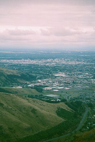
The Port Hills are a range of hills in Canterbury Region of New Zealand, so named because they lie between the city of Christchurch and its port at Lyttelton. They are an eroded remnant of the Lyttelton volcano, which erupted millions of years ago.

<span class="mw-page-title-main">Ferrymead</span> Suburb in Christchurch, New Zealand

Ferrymead is a suburb south-east of Christchurch, New Zealand. It is the main thoroughfare for reaching the eastern sea suburbs such as Sumner, as well as home to a number of cliff-top residences and businesses along the estuary front. After the 2011 Canterbury earthquake, a number of prominent Christchurch businesses relocated to the Ferrymead area, making it into a secondary business hub.

<span class="mw-page-title-main">Linwood, New Zealand</span> Suburb in Christchurch, New Zealand

Linwood is an inner suburb of the city of Christchurch, New Zealand. It lies to the east of the city centre, mostly between Ferry Road and Linwood Avenue, two of the major arterial roads to the eastern suburbs of Christchurch.

<span class="mw-page-title-main">Somerfield, New Zealand</span> Suburb in Christchurch, New Zealand

Somerfield is a suburb in the south of Christchurch, New Zealand. It is nominally bordered by the Ōpāwaho / Heathcote River to the south and west, Strickland and Colombo Streets to the east, and Milton Street to the north. The suburb includes Somerfield School, Somerfield Park and a small number of shops which service the local area, although it is predominantly residential. Somerfield is also known for its wide variety of trees, especially along the banks of the Ōpāwaho / Heathcote River.

<span class="mw-page-title-main">Burwood, New Zealand</span> Suburb in Christchurch, New Zealand

Burwood is a north-eastern suburb of Christchurch, New Zealand. The suburb is mostly a residential area and is centred on Burwood Hospital, Travis Wetland Nature Heritage Park and Bottle Lake Forest.

<span class="mw-page-title-main">Redcliffs</span> Suburb in Christchurch, New Zealand

Redcliffs is an outer coastal suburb of Christchurch, Canterbury, New Zealand.

Waverley is a suburb of the New Zealand city of Dunedin. It was named after Sir Walter Scott's novel Waverley, first novel in a series known as the Waverley Novels, among the most popular and widely read English-language novels of the 19th century. Waverley is located at the start of the Otago Peninsula, 2.4 kilometres (1.5 mi) southeast of the city centre, on a rise overlooking the Otago Harbour to the north.

<span class="mw-page-title-main">Tainui, New Zealand</span> Suburb in Dunedin, New Zealand

Tahuna and Tainui are two small, somewhat vaguely defined suburbs of the New Zealand city of Dunedin. They lie to the south of Andersons Bay and Musselburgh, close to Dunedin's southern coastline. Both are often considered parts of either Musselburgh or Andersons Bay.

<span class="mw-page-title-main">South Dunedin</span> Suburb of Dunedin, New Zealand

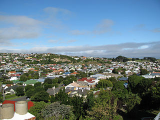
South Dunedin is a major inner city suburb of the New Zealand city of Dunedin. It is located, as its name suggests, 2.5 kilometres (1.6 mi) to the south of the city centre, on part of a large plain known locally simply as "The Flat". The suburb is a mix of industrial, retail, and predominantly lower-quality residential properties.

<span class="mw-page-title-main">Brooklands, Christchurch</span> Suburb in Christchurch, New Zealand

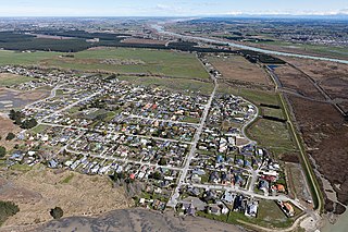
Brooklands is the northernmost suburb of Christchurch, New Zealand. The settlement was built on former swamp land adjacent to Brooklands Lagoon, which forms part of the Waimakariri River mouth. The land damage sustained in the 2010 and 2011 Christchurch earthquakes and subsequent Red Zone classification resulted in the buyout and demolition of nearly all properties in Brooklands, effectively wiping the suburb off the map.

Clifton is a hillside suburb above Sumner in Christchurch, New Zealand.

<span class="mw-page-title-main">Hillsborough, Christchurch</span> Suburb in Christchurch, New Zealand

Hillsborough is a mixed industrial and residential suburb of Christchurch, New Zealand, located approximately 4 kilometres (2.5 mi) to the south-east of the city centre.

<span class="mw-page-title-main">Kennedys Bush</span> Suburb in Christchurch, New Zealand

Kennedys Bush is a south-western suburb of Christchurch, New Zealand.

<span class="mw-page-title-main">Richmond Hill, New Zealand</span> Suburb in Christchurch, New Zealand

Richmond Hill is a hillside suburb above Sumner in Christchurch, New Zealand.

<span class="mw-page-title-main">Scarborough, New Zealand</span> Suburb in Christchurch, New Zealand

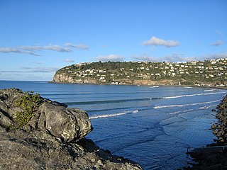
Scarborough is a hillside suburb above Sumner in Christchurch, New Zealand.

Paparangi, one of the northern suburbs of Wellington in New Zealand, lies approximately 10 km north of the city centre, north-east of Johnsonville, north-west of Newlands and south of Grenada and Woodridge. The population was 2,841 at the time of the 2013 census, an increase of 96 from the 2006 census population.

<span class="mw-page-title-main">Maupuia</span> Suburb of Wellington City, New Zealand

Maupuia on the Miramar Peninsula is an eastern suburb of Wellington to the north-west of Miramar. Developed in the 1970s, it is in the Eastern Ward.

<span class="mw-page-title-main">Bromley, New Zealand</span> Suburb in Christchurch, New Zealand

Bromley is a suburb of the city of Christchurch, New Zealand. It lies to the east of the city centre, mostly between Pages Road and the Avon river estuary.

Casebrook is a suburb on the northern side of Christchurch city.

References