Avon Heathcote Estuary

Last updated

Estuary of the Heathcote and Avon Rivers / Ihutai
AvonHeathcoteEstuaryNZ-map.png
New Zealand (relief map).png
Disc Plain red.svg
Estuary of the Heathcote and Avon Rivers / Ihutai
Coordinates 43°32′49″S172°43′23″E / 43.547°S 172.723°E / -43.547; 172.723
River sources Avon River / Ōtākaro
Ōpāwaho / Heathcote River
Ocean/sea sources Pacific Ocean
Basin  countriesNew Zealand
Surface area8 km2 (3.1 sq mi)
Settlements Christchurch

The Estuary of the Heathcote and Avon Rivers / Ihutai is the largest semi-enclosed shallow estuary in Canterbury and remains one of New Zealand's most important coastal wetlands. It is well known as an internationally important habitat for migratory birds, and it is an important recreational playground and educational resource. It was once highly valued for mahinga kai (Māori for food gathering). [1]

Contents

Location

The Avon River / Ōtākaro enters the estuary from the northwest, and the Ōpāwaho / Heathcote River from the south-west. The estuary has a triangular shape, a short inlet connection with Pegasus Bay, and is primarily enclosed by the 4-kilometre (2.5 mi) long Brighton Spit, on which the suburbs New Brighton, South New Brighton and Southshore are located.

The most prominent features of the inlet are the single deep channel between Rapanui Rock ("Shag Rock") and Brighton Spit.

Christchurch Panorama Avon Heathcote Estuary.jpg
The Avon Heathcote Estuary viewed from Clifton Hill

Description

It is shallow with the mean at high water of ordinary spring tides (HWOST) of 1.4 metres (4.6 ft)—and is predominantly intertidal, as only about 15 percent of the area lies below low water of ordinary spring tides (LWOST). [2]

Official name

The estuary's official name became Estuary of the Heathcote and Avon Rivers / Ihutai as a result of the Ngāi Tahu Claims Settlement Act 1998. [3]

History

The Land

The Estuary formed around 450 years ago and covers around 880 hectares (3.3 square miles). [4] In 1989 the Canterbury Regional Council and the Christchurch City Council drilled an exploratory bore near the mouth of the Avon River / Ōtakaro discovering layers of fossils and sediment types that showed the area had experienced shifts between being marine, estuary, swamp and floodplain over the last 2 million years. [5] The land underneath the Estuary consists of gravel embedded between fine silts and sands deposited by the rivers and sea. [6] The Brighton Spit which encloses the Estuary was formed by sand carried by the Ashley / Rakahuri and Waimakariri Rivers and as the Spit grew, the mouth of the Avon River / Ōtākaro was forced southward towards that of the Ōpāwaho / Heathcote River, forming the estuary of today. [7]

Early Māori settlement

Māori people were the first settlers in Canterbury and arrived around the 13th century according to western archaeological evidence, though Māori whakapapa (genealogies) date settlement before this period of time with the discovery of the South Island by Waitaha ancestor, Rākaihautū. [8] Traditional food gathering or mahinga kai sites of Waitaha, Rapuwai, Kāti Mamoe and subsequently Ngāi Tahu iwi included Ihutai (The Estuary). [8] The nearest kāika (settlements) included Orua Paeroa at Travis Wetland and Te Kai a Te Karoro , which was located near to South New Brighton Park, the latter supporting iwi to reside there throughout each year due to the abundance of food supplied by Ihutai. [9] [10] [11] Traditional food sources around Ihutai included pūtangitangi (Paradise Shelduck), pārera (grey duck), tuna (eels), kanakana (lamprey), īnanga (adult whitebait), pātiki (flounder) and pipi (shellfish). [12] In former times a soft-shelled perwinkle snail called whetiko flourished. [13] In March 1848 Governor George Grey negotiated sale of 20 million acres between Kaiapoi and Otago via the land purchaser Henry Kemp who obtained Māori signatures to a deed of purchase now referred to as Kemp's Purchase or Kemp's Deed. Governor Grey did not uphold all the terms of Kemp's Deed which included a promise to allow access to traditional mahinga kai and kaika nohoanga (seasonal camps) and by the 1850s Māori were barred from access to their mahinga kai sites around the estuary.

Early European settlement

Sealers and whalers were often valued by Māori who traded flax and potatoes for steel adzes, axes, muskets and other supplies and the Estuary provided an important trading route. [14] In 1837, a whaler named James Robinson Clough also known as Jimmy Robinson married Puawai a local Māori and is said to be the first European to access the Estuary. [14]

Avon–Heathcote Estuary Ihutai Trust

The Avon–Heathcote Estuary Ihutai Trust was formed in 2002. This resulted from requests from the wider community to act in the estuary's long-term interests. The members of the Trust include representatives from the community, existing groups (Friends of the Estuary and the Christchurch Estuary Association), representatives from Christchurch City Council, Environment Canterbury, tāngata whenua and other agencies. [15] As of 2024, the board also includes scientists such as emeritus professor Islay Marsden, and biologist Lesley Bolton-Ritchie. [16]

Biodiversity

In the summer of 2021 to 2022, an invertebrate survey was undertaken by Julia Palmer and a total of 175 different invertebrate species were found to inhabit the Charlesworth Reserve in the Avon-Heathcote Estuary/Ihutai. [17] [18]

Related Research Articles

<span class="mw-page-title-main">Banks Peninsula</span> Peninsula south of Christchurch, New Zealand

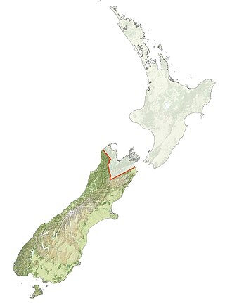
Banks Peninsula is a peninsula of volcanic origin on the east coast of the South Island of New Zealand. It has an area of approximately 1,150 square kilometres (440 sq mi) and encompasses two large harbours and many smaller bays and coves. The South Island's largest city, Christchurch, is immediately north of the peninsula.

<span class="mw-page-title-main">Ferrymead</span> Suburb of Christchurch, New Zealand

Ferrymead is a suburb south-east of Christchurch, New Zealand. It is the main thoroughfare for reaching the eastern sea suburbs such as Sumner, as well as home to a number of cliff-top residences and businesses along the estuary front. After the 2011 Canterbury earthquake, a number of prominent Christchurch businesses relocated to the Ferrymead area, making it into a secondary business hub.

<span class="mw-page-title-main">Ngāi Tahu</span> Māori iwi in New Zealand

Ngāi Tahu, or Kāi Tahu, is the principal Māori iwi (tribe) of the South Island. Its takiwā is the largest in New Zealand, and extends from the White Bluffs / Te Parinui o Whiti, Mount Mahanga and Kahurangi Point in the north to Stewart Island / Rakiura in the south. The takiwā comprises 18 rūnanga corresponding to traditional settlements. According to the 2018 census an estimated 74,082 people affiliated with the Kāi Tahu iwi.

<span class="mw-page-title-main">Kaiapoi</span> Town in Canterbury, New Zealand

Kaiapoi is a town in the Waimakariri District of the Canterbury region, in the South Island of New Zealand. The town is located approximately 17 kilometres north of central Christchurch, close to the mouth of the Waimakariri River. It is considered a satellite town of Christchurch and is part of the Christchurch functional urban area.

<span class="mw-page-title-main">Pegasus Bay</span> Bay in South Island

Pegasus Bay, earlier known as Cook's Mistake, is a bay on the east coast of the South Island of New Zealand, to the north of Banks Peninsula.

<span class="mw-page-title-main">Ōpāwaho / Heathcote River</span> River in Christchurch, New Zealand

The Ōpāwaho / Heathcote River lies within the city boundaries of Christchurch, New Zealand, and is fed from springs near Templeton Road, with a catchment area in wet weather extending as far west as Yaldhurst and Pound Road. It meanders around the base of the Port Hills from west to south-east.

<span class="mw-page-title-main">Lake Ellesmere / Te Waihora</span> Lagoon in New Zealand

Lake Ellesmere / Te Waihora is a broad, shallow coastal lake or waituna, in the Canterbury region of the South Island of New Zealand. It is directly to the west of Banks Peninsula, separated from the Pacific Ocean by the long, narrow, sandy Kaitorete Spit, or more correctly Kaitorete Barrier. It lies partially in extreme southeastern Selwyn District and partially in the southwestern extension of the former Banks Peninsula District, which now is a ward in the city of Christchurch. The lake holds high historical and cultural significance to the indigenous Māori population and the traditional Māori name Te Waihora, means spreading waters. It has officially had a dual English/Māori name since at least 1938.

<span class="mw-page-title-main">New Brighton, New Zealand</span> Coastal suburb of Christchurch, NZ

New Brighton is a coastal suburb of Christchurch, New Zealand, 8 kilometres (5.0 mi) east of the city centre. It is one of eastern Christchurch's main entertainment and tourist centres, with its architecturally unique pier and scenic coastline. The 2011 Christchurch earthquakes caused significant damage in the area.

Kāti Māmoe is a historic Māori iwi. Originally from the Hastings area, they moved in the 16th century to the South Island which at the time was already occupied by the Waitaha.

Waitaha, an early Māori iwi, inhabited the South Island of New Zealand. They were largely absorbed via marriage and conquest - first by the Ngāti Māmoe and then by Ngāi Tahu - from the 16th century onward. Today those of Waitaha descent are represented by the Ngāi Tahu iwi. Like Ngāi Tahu today, Waitaha was itself a collection of various ancient iwi. Kāti Rākai was said to be one of Waitaha's hapū.

<span class="mw-page-title-main">Port Levy</span>

Port Levy is a long, sheltered bay and settlement on Banks Peninsula in Canterbury, New Zealand. The current population is under 100, but in the mid-19th century it was the largest Māori settlement in Canterbury with a population of about 400 people. It is named after Solomon Levey, an Australian merchant and ship owner who sent a number of trading vessels to the Banks Peninsula area during the 1820s.

<span class="mw-page-title-main">Redcliffs</span> Suburb of Christchurch, New Zealand

Redcliffs is an outer coastal suburb of Christchurch, Canterbury, New Zealand.

<span class="mw-page-title-main">Lake Forsyth</span>

Lake Forsyth is a lake on the south-western side of Banks Peninsula in the Canterbury region of New Zealand, near the eastern end of the much larger Lake Ellesmere / Te Waihora. State Highway 75 to Akaroa and the Little River Rail Trail run along the north-western side of the lake.

<span class="mw-page-title-main">Avon River / Ōtākaro</span> River in Christchurch, New Zealand

The Avon River / Ōtākaro flows through the centre of the city of Christchurch, New Zealand, and out to an estuary, which it shares with the Ōpāwaho / Heathcote River, the Avon Heathcote Estuary / Ihutai.

<span class="mw-page-title-main">Victoria Square, Christchurch</span> Public place in Christchurch, New Zealand

Victoria Square is located in central Christchurch, New Zealand. Originally known as Market Place or Market Square, it was the site of market days, fairs, and trade before its redevelopment in 1896–1897 into a park. Subsequent to the February 2011 earthquake, the square was located in the Central City Red Zone and was closed, reopening in November 2012. Its notable landmarks include the Captain James Cook statue, Queen Victoria statue, H. L. Bowker Fountain, and the Victoria Square Poupou. It also features the country's oldest cast iron and stone bridge, now known as the Hamish Hay Bridge.

Rākaihautū was the captain of the Uruaokapuarangi canoe and a Polynesian ancestor of various iwi, most famously of Waitaha and other southern groups, though he is also known in the traditions of Taitokerau, and in those of Rarotonga.

<span class="mw-page-title-main">Residential red zone</span> Unhabitable areas around Christchurch, New Zealand

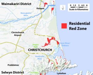
A residential red zone is any of several areas of land in and around Christchurch, New Zealand, that experienced severe damage in the 2010 and 2011 Christchurch earthquakes and were deemed infeasible to rebuild on. Through voluntary buyouts, the Crown acquired and demolished or removed over 8,000 properties. The majority were located in a broad swath of the eastern suburbs along the Avon River / Ōtākaro that had suffered damage from soil liquefaction.
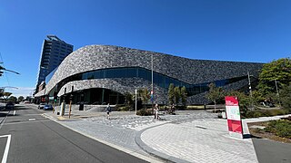
Charles Eldon Fayne Robinson is a New Zealand Māori artist specialising in carving. Robinson has contributed to the carving of buildings on many marae in New Zealand as well as exhibiting his art in galleries and museums.

<span class="mw-page-title-main">Christchurch Wastewater Treatment Plant</span>

The Christchurch Wastewater Treatment Plant (CWTP), also known as the Bromley sewage plant, is the main wastewater treatment plant of Christchurch, New Zealand. It is located in the suburb of Bromley, adjacent to the Avon Heathcote Estuary. Opened in 1962, it replaced an earlier sewage disposal farm that had operated since 1882. In late 2021, two trickling filters burned down and adjacent suburbs have since been subjected to a putrid smell.

Riki Henare Manuel is a New Zealand Māori carver and tohunga moko of Ngāti Porou descent.

References

  1. Newsletter Archived May 23, 2010, at the Wayback Machine , Estuary Trust, New Zealand, 2007.
  2. Post-1847 changes in the Avon-Heathcote Estuary, Christchurch: a study of the effect of urban development around a tidal estuary Archived February 10, 2009, at the Wayback Machine , Royal Society of New Zealand.
  3. "Ngāi Tahu Claims Settlement Act 1998".
  4. Owen 1992, p. 2.
  5. Owen 1992, p. 3.
  6. Owen 1992, p. 4.
  7. Owen 1992, p. 5.
  8. 1 2 Owen 1992, p. 10-14.
  9. Tau, Te Maire; Goodall, Anake; Palmer, David; Tau, Rakiihia (1990). Te whakatau kaupapa: Ngai Tahu resource management strategy for the Canterbury region. Wellington, New Zealand: Aoraki Press. pp. (5)23 - (5)24. ISBN   0908925069. Archived from the original on 27 July 2022. Retrieved 28 July 2022.
  10. Ngāi Tahu. "Te-Kai-a-Te-Karoro". Ka Huru Manu : The Ngāi Tahu atlas. Retrieved 28 July 2022.
  11. Christchurch City Council. "Christchurch before 1850" (PDF). Retrieved 28 July 2022.
  12. Owen 1992, p. 12.
  13. Owen 1992, p. 14.
  14. 1 2 Owen 1992, p. 18.
  15. History Archived May 23, 2010, at the Wayback Machine , Estuary Trust, New Zealand.
  16. "Board members Archives". Avon-Heathcote Estuary Trust. Retrieved 2024-03-02.
  17. "Surprise find – 175 invertebrate species in city wetland". Newsline. 2022-06-21. Retrieved 2022-06-25.
  18. Palmer, Julia (22 February 2022). "Charlesworth Reserve Invertebrate Survey, Christchurch, Summer 2021 – 2022" (PDF). www.estuary.org.nz. Retrieved 25 June 2022.

Literature