
The South Island is the largest of the three major islands of New Zealand in surface area, the other being the smaller but more populous North Island and sparsely populated Stewart Island. It is bordered to the north by Cook Strait, to the west by the Tasman Sea, to the south by the Foveaux Strait and Southern Ocean, and to the east by the Pacific Ocean. The South Island covers 150,437 square kilometres (58,084 sq mi), making it the world's 12th-largest island, constituting 56% of New Zealand's land area. At low altitudes, it has an oceanic climate.

Banks Peninsula is a peninsula of volcanic origin on the east coast of the South Island of New Zealand. It has an area of approximately 1,200 square kilometres (450 sq mi) and encompasses two large harbours and many smaller bays and coves. The South Island's largest city, Christchurch, is immediately north of the peninsula.
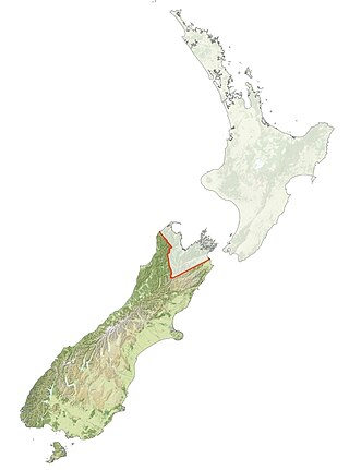
Ngāi Tahu, or Kāi Tahu, is the principal Māori iwi (tribe) of the South Island. Its takiwā is the largest in New Zealand, and extends from the White Bluffs / Te Parinui o Whiti, Mount Mahanga and Kahurangi Point in the north to Stewart Island / Rakiura in the south. The takiwā comprises 18 rūnanga corresponding to traditional settlements. According to the 2018 census an estimated 74,082 people affiliated with the Kāi Tahu iwi.

Christchurch is the largest city in the South Island and the second-largest city by urban area population in New Zealand, after Auckland. Christchurch lies in the Canterbury Region, near the centre of the east coast of the South Island, east of the Canterbury Plains. It is located near the southern end of Pegasus Bay, and is bounded to the east by the Pacific Ocean and to the south by Banks Peninsula. The Avon River / Ōtākaro flows through the centre of the city, with a large urban park along its banks. Christchurch has a reputation for being an 'English' city, with its architectural identity and common nickname the "Garden City" due to similarities with garden cities in England.

The Waimakariri River is one of the largest rivers in Canterbury, on the eastern coast of New Zealand's South Island. It flows for 151 kilometres (94 mi) in a generally southeastward direction from the Southern Alps across the Canterbury Plains to the Pacific Ocean.

The Ōpāwaho / Heathcote River lies within the city boundaries of Christchurch, New Zealand, and is fed from springs near Templeton Road, with a catchment area in wet weather extending as far west as Yaldhurst and Pound Road. It meanders around the base of the Port Hills from west to south-east.

Port Levy is a long, sheltered bay and settlement on Banks Peninsula in Canterbury, New Zealand. The current population is under 100, but in the mid-19th century it was the largest Māori settlement in Canterbury with a population of about 400 people. It is named after Solomon Levey, an Australian merchant and ship owner who sent a number of trading vessels to the Banks Peninsula area during the 1820s.

Central Plains Water, or, more fully, the Central Plains Water Enhancement Scheme, is a large-scale proposal for water diversion, damming, reticulation and irrigation for the Central Plains of Canterbury, New Zealand. Construction started on the scheme in 2014.

Sir Stephen Gerard "Tipene" O'Regan is a New Zealand academic, company director and former chairman of the Ngāi Tahu Māori Trust Board.

The Avon River / Ōtākaro flows through the centre of the city of Christchurch, New Zealand, and out to an estuary, which it shares with the Ōpāwaho / Heathcote River, the Avon Heathcote Estuary / Ihutai.

The Styx River runs along the northern boundary of Christchurch, New Zealand before flowing into the Waimakariri River close to its mouth via Brooklands Lagoon.

The Estuary of the Heathcote and Avon Rivers / Ihutai is the largest semi-enclosed shallow estuary in Canterbury and remains one of New Zealand's most important coastal wetlands. It is well known as an internationally important habitat for migratory birds, and it is an important recreational playground and educational resource. It was once highly valued for mahinga kai.

Victoria Square is a public park located in central Christchurch, New Zealand. Originally known by European settlers as Market Place or Market Square, it was renamed to Victoria Square in 1903 in honour of Queen Victoria. It was one of the four squares included in the original plan of Christchurch when the city was laid out in 1850.

Te Rāpaki-o-Te Rakiwhakaputa, commonly known as Rāpaki or Rapaki, is a small settlement within the Lyttelton Harbour basin.
Areta Rachael Wilkinson is a New Zealand jeweller.
Ngāi Tahu Holdings Corporation Limited is owned by the Ngāi Tahu iwi of the South Island of the New Zealand. Its main interests are in tourism, fisheries, property and forestry and it is among the wealthiest iwi in New Zealand. Ngāi Tahu annually contributes more than $200 million to the South Island economy.

Takapūneke, with the location also known as Red House Bay, is a former kāinga—an unfortified Māori village—adjacent to present-day Akaroa, New Zealand. Takapūneke was a major trading post for the local iwi (tribe), Ngāi Tahu, as there was safe anchorage for European vessels. The site is of significance to Ngāi Tahu as their tribal chief, Tama-i-hara-nui, was captured here by North Island Ngāti Toa chief Te Rauparaha, and then tortured and killed. The village itself was raided and subject of a massacre, with the events subsequently called the Elizabeth affair. There is a direct link from the massacre in 1830 to the signing of the Treaty of Waitangi in 1840, giving the site a status of national significance.

Coopers Lagoon / Muriwai is a small coastal waituna-type lagoon in the Canterbury region of New Zealand, located approximately halfway between the mouth of the Rakaia River and the outlet of the much larger Lake Ellesmere / Te Waihora. While the present-day lagoon is separated from the nearby Canterbury Bight by approximately 100 metres (330 ft), the water of the lagoon is considered brackish and early survey maps show that, until recently, the lagoon was connected to the ocean by a small channel. The lagoon, along with the surrounding wetlands, has historically been an important mahinga kai for local Māori.
North New Brighton is a suburb on the northern side of Christchurch city. It was originally known as North Beach and was readily accessible from Christchurch city by tram. It was renamed North New Brighton in 1953.

The Christchurch Wastewater Treatment Plant (CWTP), also known as the Bromley sewage plant, is the main wastewater treatment plant of Christchurch, New Zealand. It is located in the suburb of Bromley, adjacent to the Avon Heathcote Estuary. Opened in 1962, it replaced an earlier sewage disposal farm that had operated since 1882. In late 2021, two trickling filters burned down and adjacent suburbs have since been subjected to a putrid smell.

