Rapanui Rock

Last updated

Rapanui (Shag Rock) after the 22 February 2011 earthquake. Shag Rock.JPG
Rapanui (Shag Rock) after the 22 February 2011 earthquake.
Rapanui (Shag Rock). Before the 2011 earthquakes ShagRockSumner.JPG
Rapanui (Shag Rock). Before the 2011 earthquakes

Shag Rock, also known as Rapanui, is a notable sea stack that marks the entrance of the Avon Heathcote Estuary near Christchurch, New Zealand. It is a prominent landmark for navigators at sea as well as travelers on the road to Sumner. The rock stands close to the southern shore just above the low tide level. In the February 2011 Christchurch earthquake it shattered and the remains, which are still easily seen from the road, have, with dark humour by some locals, been called "Shag Pile" (a pun referencing the style of carpet).

Contents

Although no longer used by shipping, the estuary is accessible as far as Ferrymead using shallow draught vessels up to about 30 tons if the bar is crossed in favourable wind, sea and tidal conditions. The shipping channel into the estuary lies to the northern side of the rock.

Toponymy

Rapanui at sunset Rapanui Rock during sunset, Sumner, Christchurch, New Zealand.jpg
Rapanui at sunset

Rapanui is the Māori name for the "black, tooth-like rock" on the beach at the mouth of the Avon-Heathcote Estuary, according to James Cowan when he retold a 200-year-old Maori legend. [1] [2] According to Waitaha Taiwhenua o Waitaki tradition the name means the great sternpost and is one of the oldest landmarks of Te Wai Pounamu, standing at the entrance to the Ōpāwaho/Ōtākaro (Heathcote/Avon) estuary. [3] [4] Sumner Town Clerk, J. F. Menzies, suggests that the Māori navigators approaching the rock from seaward might exclaim "Te Rapanui" - "the great sternpost" when they saw the rock formation because it resembles "the huge sternpost of a canoe with its base extending landwards." [5] An alternative translation of scattered stones deeply embedded in the ground is also appropriate, according to Gordon Ogilvie, a local historian. [6]

The Sumner Borough Council resolved that the rock be known as Rapanui in all its official documents, as well as giving the same name a nearby water reservoir. [5]

Shag Rock appears as the name of this feature on HMS Pandora's December 1854 survey chart of the Sumner Bar. [2] [7] It appeared as an unnamed feature on maps from as early as 1852.

Since the 2011 earthquakes shattered the rock and scattered some of the fragments, the rock pile, significantly reduced in height, has been referred to as Shag Pile, a pun on the carpet style or, more rudely, as Shagged Rock, by some locals possessing a darker sense of humour. [6] [8]

Geology

The rock is a notable sea stack [ citation needed ] that has been isolated from the nearby cliff by various erosive process. The changes in the size and shape of the rock seen in the 2010-2011 earthquake sequence are part of this ongoing natural process. The adjacent cliff collapse seen in the recent earthquakes is suggestive of how the rock stack became disconnected from the adjacent cliff face. Also, the rock field on the landward side of the rock stack suggests that the stack was significantly larger in pre-historic times.[ citation needed ]

Before the 2011 Canterbury earthquake

The rock rose about 11 metres above the sea, depending on the state of the tide. [9]

2011 Canterbury earthquake

It crumbled during the 6.3 earthquake of 22 February 2011, which reduced its height. [10]

The rock is a prominent landmark for navigators at sea as well as travellers on the road to Sumner.[ citation needed ] It marks the outflow from the Avon Heathcote Estuary. The rock stands close to the southern shore and is accessible from the beach at low tide.[ citation needed ] Because of its height and separation from the background cliffs it serves as a natural navigation marker that can be used by navigators to judge a vessel's position at sea, especially when close to shore in the shoaling waters in the vicinity of the Sumner Bar. [11] [ additional citation(s) needed ] During the 19th century the estuary outflow flowed much closer inshore, across the beach towards the nearby Cave Rock before sweeping out to sea. [11] When the bar area was surveyed by HMS Pandora in 1854, the sandbar the extended from the Southshore was exposed at half tide seaward of much of Sumner beach and the outflow channel swept the beach area free of sand, forming a small bay where there is now a sizeable beach. [11] [ additional citation(s) needed ] The former shoreline is apparent from historic photographs and painting of Sumner beach showing roads at the water's edge, and a jetty into the bay where the beachside tea rooms are now.[ citation needed ]

At the time of the HMS Pandora survey, the shipping channel required vessels to sail close to and almost directly at Cave Rock before rounding a knee in the channel and sailing across the beach to round Shag Rock. Today, the channel between the estuary and the sea flows more directly out to sea on the northern side of the rock.[ citation needed ]

Although no longer used by shipping, the estuary was accessible as far as Ferrymead using shallow draught vessels up to about 30 tons, if the bar is crossed in favourable wind, sea and tidal conditions.[ citation needed ] Ships could even sail up the Avon River to the Bricks near present day Barbados Street in the central city, as well as up the Heathcote River as far as where the Radley Street Bridge is now.[ citation needed ] Steamers could easily sail upriver as far as Steam Wharf, by the Tunnel Road roundabout on Ferry Road, where there is a memorial today.[ citation needed ] Above Steam Wharf the Heathcote river became too narrow for steamers to turn around, however the channel was still deep enough to service the industrial area.[ citation needed ]

Art and Culture

Shag Rock and its environment has been the subject of art since the 19th century.

Photography

Shag Rock has been the subject of photographs from as early as 1861. [12] [13]

Poetry

There is an Ode to Shag Rock. [8]

Visual arts

Artists who have used Shag Rock in their works include

There is a Dulux paint colour called Shag Rock. [19] [20]

Rogue art

A "Rogue Art" sculpture of a paper airplane, about a metre long and made from sheet steel, was installed on top of the rock in late February 2020. [3] The artwork appeared in mysterious circumstances overnight and because permission of the local hapu had not been obtained, and they objected, the City Council later removed the artwork by sawing it off at its base and were investigating prosecuting the culprits. [3] [21] The "Rogue Artist" late contacted a local reporter to apologize for their ill-informed actions and explain the artwork was called "Crash but we do not burn – February 22, 2011" and installed to commemorate the tenth anniversary of the 2011 Christchurch earthquake. [21]

See also

Related Research Articles

<span class="mw-page-title-main">Banks Peninsula</span> Peninsula south of Christchurch, New Zealand

Banks Peninsula is a peninsula of volcanic origin on the east coast of the South Island of New Zealand. It has an area of approximately 1,150 square kilometres (440 sq mi) and encompasses two large harbours and many smaller bays and coves. The South Island's largest city, Christchurch, is immediately north of the peninsula.

<span class="mw-page-title-main">Sumner, New Zealand</span> Suburb of Christchurch, New Zealand

Sumner is a coastal seaside suburb of Christchurch, New Zealand and was surveyed and named in 1849 in honour of John Bird Sumner, the then newly appointed Archbishop of Canterbury and president of the Canterbury Association. Originally a separate borough, it was amalgamated with the city of Christchurch as communications improved and the economies of scale made small town boroughs uneconomic to operate.

<span class="mw-page-title-main">Kaikōura</span> Town in the South Island of New Zealand

Kaikōura is a town on the east coast of the South Island of New Zealand. It is located on State Highway 1, 180 km north of Christchurch. The town has an estimated permanent resident population of 2,360.

<span class="mw-page-title-main">Ferrymead</span> Suburb of Christchurch, New Zealand

Ferrymead is a suburb south-east of Christchurch, New Zealand. It is the main thoroughfare for reaching the eastern sea suburbs such as Sumner, as well as home to a number of cliff-top residences and businesses along the estuary front. After the 2011 Canterbury earthquake, a number of prominent Christchurch businesses relocated to the Ferrymead area, making it into a secondary business hub.

<span class="mw-page-title-main">Christchurch</span> City in Canterbury, New Zealand

Christchurch is the largest city in the South Island of New Zealand and the seat of the Canterbury Region. Christchurch lies on the South Island's east coast, just north of Banks Peninsula on Pegasus Bay. The Avon River (Ōtākaro) flows through the centre of the city, with an urban park along its banks.

<span class="mw-page-title-main">Pegasus Bay</span> Bay in South Island

Pegasus Bay, earlier known as Cook's Mistake, is a bay on the east coast of the South Island of New Zealand, to the north of Banks Peninsula.

<span class="mw-page-title-main">New Brighton, New Zealand</span> Coastal suburb of Christchurch, NZ

New Brighton is a coastal suburb of Christchurch, New Zealand, 8 kilometres (5.0 mi) east of the city centre. It is one of eastern Christchurch's main entertainment and tourist centres, with its architecturally unique pier and scenic coastline. The 2011 Christchurch earthquakes caused significant damage in the area.

<span class="mw-page-title-main">Bridle Path (New Zealand)</span>

The Bridle Path is a steep shared-use track that traverses the northern rim of the Lyttelton volcano connecting the port of Lyttelton with the city of Christchurch in the South Island of New Zealand. It is a popular walking and mountain biking route. The track ascends from the port itself to a height of 333 metres (1,093 ft) before descending again via Heathcote Valley to Christchurch. At the summit, next to the Summit Road, is a stone shelter with covered seats that is a 1940 New Zealand centennial memorial to the Pioneer Women of Canterbury. There are also seven commemorative stone seats placed along the Bridle Path; most of these were built for the 1950 Canterbury centenary celebrations.

<span class="mw-page-title-main">Lyttelton Harbour</span> Inlet on Banks Peninsula, New Zealand

Lyttelton Harbour / Whakaraupō is a major inlet on the northwest side of Banks Peninsula, on the coast of Canterbury, New Zealand; the other major inlet is Akaroa Harbour, which enters from the southern side of the peninsula. Whakaraupō enters from the northern coast of the peninsula, heading in a predominantly westerly direction for approximately 15 km (9.3 mi) from its mouth to the aptly-named Head of the Bay near Teddington. The harbour sits in an eroded caldera of the ancient Banks Peninsula Volcano, the steep sides of which form the Port Hills on its northern shore.

<span class="mw-page-title-main">Bexley, New Zealand</span> Suburb of Christchurch, New Zealand

The suburb of Bexley is situated in East Christchurch on the west bank of the Avon River approximately one kilometre from the Avon Heathcote Estuary. It is enclosed within a bend in the Avon River and borders the suburb of Aranui.

<span class="mw-page-title-main">Lyttelton road tunnel</span> Road tunnel in Christchurch, New Zealand

The Lyttelton road tunnel runs through the Port Hills to connect the New Zealand city of Christchurch and its seaport, Lyttelton. It opened in on 27 February 1964 and carries just over 10,000 vehicles per day as part of State Highway 74.

<span class="mw-page-title-main">Redcliffs</span> Suburb of Christchurch, New Zealand

Redcliffs is an outer coastal suburb of Christchurch, Canterbury, New Zealand.

<span class="mw-page-title-main">Lyttelton Rail Tunnel</span> Railway tunnel in Christchurch, New Zealand

The Lyttelton Rail Tunnel, initially called the Moorhouse Tunnel, links the city of Christchurch with the port of Lyttelton in the Canterbury region of New Zealand's South Island. It is the country's oldest operational rail tunnel, and is on the Lyttelton Line, one of the first railways built by Canterbury Provincial Railways.

<span class="mw-page-title-main">Avon River / Ōtākaro</span> River in Christchurch, New Zealand

The Avon River / Ōtākaro flows through the centre of the city of Christchurch, New Zealand, and out to an estuary, which it shares with the Ōpāwaho / Heathcote River, the Avon Heathcote Estuary / Ihutai.

<span class="mw-page-title-main">Avon Heathcote Estuary</span>

The Estuary of the Heathcote and Avon Rivers / Ihutai is the largest semi-enclosed shallow estuary in Canterbury and remains one of New Zealand's most important coastal wetlands. It is well known as an internationally important habitat for migratory birds, and it is an important recreational playground and educational resource. It was once highly valued for mahinga kai.

<span class="mw-page-title-main">Scarborough, New Zealand</span> Suburb in Christchurch, New Zealand

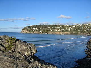
Scarborough is a hillside suburb above Sumner in Christchurch, New Zealand.

HMS <i>Pandora</i> (1833) Brig of the Royal Navy

HMS Pandora was a 3-gun brig of the Royal Navy, in service from 1833 to 1862.

<span class="mw-page-title-main">Bromley, New Zealand</span> Suburb of Christchurch, New Zealand

Bromley is a suburb of the city of Christchurch, New Zealand. It lies to the east of the city centre, mostly between Pages Road and the Avon river estuary.

<span class="mw-page-title-main">Residential red zone</span> Unhabitable areas around Christchurch, New Zealand

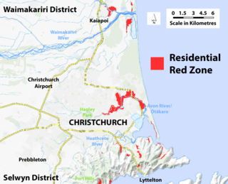
A residential red zone is any of several areas of land in and around Christchurch, New Zealand, that experienced severe damage in the 2010 and 2011 Christchurch earthquakes and were deemed infeasible to rebuild on. Through voluntary buyouts, the Crown acquired and demolished or removed over 8,000 properties. The majority were located in a broad swath of the eastern suburbs along the Avon River / Ōtākaro that had suffered damage from soil liquefaction.

<span class="mw-page-title-main">Christchurch Wastewater Treatment Plant</span>

The Christchurch Wastewater Treatment Plant (CWTP), also known as the Bromley sewage plant, is the main wastewater treatment plant of Christchurch, New Zealand. It is located in the suburb of Bromley, adjacent to the Avon Heathcote Estuary. Opened in 1962, it replaced an earlier sewage disposal farm that had operated since 1882. In late 2021, two trickling filters burned down and adjacent suburbs have since been subjected to a putrid smell.

References

  1. Cowan, James (1987). "EPISODE III. THE LAUNCHING OF THE SPELL". LEGENDS OF THE MAORI. Southern Reprints. p. 99. Retrieved 12 January 2021. And the dwellers in the riverbank pa, Pohoareare, men, women and children, launched their canoes and paddled down the slow Opaawaho, across the shallows of Ohikaparuparu, or, literally, "Fall-in-the-mud", and so out past the black, tooth-like rock of Rapanui to the firm beach sands, where Sumner township stands to-day.
  2. 1 2 Andersen, Johnannes C. (1927). "Map of Banks Peninsula showing principal surviving European and Maori place-names (in: Place-names of Banks Peninsula : a topographical history)". Wellington, New Zealand: Govt. Printer. Retrieved 12 January 2021.
  3. 1 2 3 O'Callaghan, Jody (3 June 2020). "'Rogue' art on iconic Christchurch Shag Rock". The Press. Stuff. Retrieved 13 January 2021.
  4. "Rapanui – Shag Rock". my.christchurchcitylibraries.com. Christchurch City Libraries. Retrieved 13 January 2021.
  5. 1 2 Menzies, J. F. (1941). "Rapanui-Shag Rock". Sumner (PDF). Sumner, Christchurch, New Zealand: Sumner Borough Council. pp. 38–39. Retrieved 6 February 2021.
  6. 1 2 Ansley, Bruce (2011). Christchurch Heritage. Auckland: Random House New Zealand. p. 206. ISBN   978 1 86979 863 5.
  7. Amodeo, Colin, ed. (1998). Rescue, The Sumner community and its lifeboat service (Limp Bound ed.). Sumner, Christchurch, New Zealand: Sumner Lifeboat Institute Incorporated. p. 2. ISBN   0-473-05164-8.
  8. 1 2 Ode to Shag Rock / Rapanui, Christchurch Art Gallery, New Zealand.]
  9. "Geographic Features of Significance" (PDF). Christchurch City Council . Retrieved 27 September 2011.
  10. "On shaky ground". Stuff.co.nz. 8 April 2011. Retrieved 27 September 2011.
  11. 1 2 3 Richards, G.H. [George Henry]; Evans, F.J. [Fredrick John Owen] (1875). "Avon River". New Zealand Pilot (Various download options available) (Fourth ed.). London: Hydrographic Office, Admiralty. pp. 210–211. Retrieved 20 January 2021. From surveys made by H.M. ships Acheron and Pandora, Captain J. Lort Stokes, and Commander Byron Drury, 1848-55.
  12. Barker, Alfred Charles (January 1861). "Glass Plate Positive Stereograph Slide: Shag Rock" . Retrieved 20 January 2021. One landscape format black and white glass plate positive stereograph slide depicting a man standing in front of Shag Rock
  13. 1 2 William Travers (politician), The Shag Rock, Sumner, Canterbury (Albumen photographic print), Auckland: Auckland Art Gallery, New Zealand., Accession no 1988/17/1, retrieved 20 January 2021
  14. Price, William Archer. "View of Shag Rock at Sumner, near Christchurch" (Dry plate glass negative). National Library of New Zealand (natlib.govt.nz). Wellington, New Zealand: Alexander Turnbull Library. /records/22736213. Retrieved 20 January 2021.
  15. Barraud, Chales D (1869). "Shag Rock, Sumner". Christchurch Art Gallery. Retrieved 13 January 2021. Purchased 2017 Watercolour 400 x 568mm 2017/085
  16. Barraud, Charles D. "Sumner Rocks, Banks Peninsula". Christchurch Art Gallery. Retrieved 13 January 2021. Original wood-engraving, watercolour tinted 100 x 177mm 79/58
  17. Hodgkins, William Mathew (April 1870). "1833-1898 :The Shag Rock, Sumner, Christchurch". natlib.govt.nz/. Retrieved 13 January 2021. Hodgkins, William Mathew, 1833-1898: The Shag Rock, Sumner, Christchurch [April, 1870?]. Ref: A-027-018. Alexander Turnbull Library, Wellington, New Zealand. /records/23130029
  18. Hodgkins, William Mathew (1 April 1870). "The Sumner River, Canterbury, from the Cave Rock, 1 April 1870". natlib.govt.nz/. Retrieved 13 January 2021. Hodgkins, William Mathew, 1833-1898 :The Sumner River, Canterbury, from the Cave Rock, 1 April 1870. Ref: A-027-016. Alexander Turnbull Library, Wellington, New Zealand. /records/23054398
  19. "Dulux Weathershield paint chart". www.bunnings.co.nz/dulux-weathershield-10l-ultra-deep-semi-gloss-exterior-paint_p0144851. Dulux Paints. Retrieved 13 January 2021.
  20. "Shag Rock NZ10H8". Dulux Colour Specifier (dulux.com.au). DuluxGroup Ltd. Retrieved 13 January 2021.
  21. 1 2 O'Callaghan, Jody (11 June 2020). "'Rogue artist' who put sculpture on Shag Rock in darkness says sorry". Stuff. Retrieved 6 February 2021.

Sources

43°33′47″S172°45′02″E / 43.5631°S 172.7505°E / -43.5631; 172.7505