Scarborough, New Zealand

Last updated

Scarborough
ChristchurchScarborough2 gobeirne.jpg
Scarborough seen from Sumner beach; Nicholson Park is the area to the left just below the ridgeline
Scarborough, New Zealand
Coordinates: 43°34′28″S172°46′19″E / 43.57444°S 172.77194°E / -43.57444; 172.77194
CountryNew Zealand
City Christchurch
Local authority Christchurch City Council
Electoral wardHeathcote
Area
[1]
  Land117 ha (289 acres)
Population
 (2018 Census) [2]
  Total747
(Pegasus Bay)
Sumner, New Zealand
Pfeil oben.svg
Pfeil links.svgScarboroughPfeil rechts.svg
Pfeil unten.svg
Port Hills Te Onepoto / Taylors Mistake

Scarborough is a hillside suburb above Sumner in Christchurch, New Zealand.

Contents

Scarborough is located between Sumner and Te Onepoto / Taylors Mistake. [3] It was named for the seaside resort in North Yorkshire, England. [4] The first European owner of most of the land was Major Alfred Hornbrook, [5] whose Mount Pleasant run stretched as far east as Godley Head. A small land parcel of 25 acres (10 ha) near present-day Nicholson Park belonged to Charles Church Haslewood, who died in May 1858 when his hunting gun discharged while he looked down the barrel. [3]

The land was purchased by R. M. Morten, and after his death, his sons had Scarborough subdivided into 65 sections by July 1911. [3] The first person who built in the area was Donald Paterson, a civil engineer. Patterson purchased all the land in the triangle formed by Scarborough Road and Flowers Track, and had it resurveyed into 41 sections, twice the number of the Morten brother survey. [6]

Nicholson Park has views from a number of vantage points in this 4 hectares (0.040 km2) location, [7] with views of Sumner and the Canterbury coastline. Flowers Track can be descended from here, and it was the main start point of the walking track along the cliff tops that formed an early connection between Sumner and Taylors Mistake. [7] The track went past Whitewash Head and Sumner Head; the former name was first recorded by Thomas Potts in his book Out in the Open in 1882 and it is presumed that it refers to the white appearance from shag droppings. [3] The walkway was destroyed in the two earthquakes that hit on 13 June 2011; the first had its epicentre in Taylor's Mistake, and the second had its epicentre in Sumner. Much of the cliff faces collapsed into the sea below. [8]

Some of the land near the cliffs has been red zoned and purchased by the Canterbury Earthquake Recovery Authority. Houses on those properties are to be demolished, and the land is so unstable that drones are used to survey the land for establishing the best demolition method. [9]

Demographics

Scarborough is part of the Sumner SA2 statistical area. [10]

Historical population
YearPop.±% p.a.
2006783    
2013705−1.49%
2018747+1.16%
Source: [2]

Scarborough, comprising the statistical areas of 7026596–599, which also include Te Onepoto / Taylors Mistake, covers 1.17 km2 (0.45 sq mi). [1] It had a population of 747 at the 2018 New Zealand census, an increase of 42 people (6.0%) since the 2013 census, and a decrease of 36 people (-4.6%) since the 2006 census. There were 285 households. There were 381 males and 363 females, giving a sex ratio of 1.05 males per female, with 108 people (14.5%) aged under 15 years, 117 (15.7%) aged 15 to 29, 390 (52.2%) aged 30 to 64, and 129 (17.3%) aged 65 or older.

Ethnicities were 96.0% European/Pākehā, 4.0% Māori, 0.4% Pacific peoples, 2.4% Asian, and 2.0% other ethnicities (totals add to more than 100% since people could identify with multiple ethnicities).

Although some people objected to giving their religion, 51.8% had no religion, 37.8% were Christian, 0.4% were Hindu, 0.4% were Buddhist and 3.6% had other religions.

Of those at least 15 years old, 279 (43.7%) people had a bachelor or higher degree, and 39 (6.1%) people had no formal qualifications. The employment status of those at least 15 was that 303 (47.4%) people were employed full-time, 117 (18.3%) were part-time, and 15 (2.3%) were unemployed. [2]

Scarborough, Christchurch, New Zealand.jpg
Panoramic view of Scarborough from Sumner Beach

Notes

  1. 1 2 "ArcGIS Web Application". statsnz.maps.arcgis.com. Retrieved 11 October 2021.
  2. 1 2 3 "Statistical area 1 dataset for 2018 Census". Statistics New Zealand. March 2020. 7026596–599.
  3. 1 2 3 4 Ogilvie 2009, p. 28.
  4. Harper, Margaret (20 February 2014). "Christchurch Place Names: N - Z" (PDF). Christchurch City Libraries. p. 50. Retrieved 1 March 2014.
  5. Scholefield 1940, p. 413.
  6. Ogilvie 2009, pp. 28f.
  7. 1 2 Ogilvie 2009, p. 31.
  8. "Video: Quake hit Whitewash Head". The Press . 20 June 2011. Retrieved 1 March 2014.
  9. "Drones film damage". The Press . 27 February 2014. p. A3. Retrieved 1 March 2014.
  10. 2018 Census place summary: Sumner

Related Research Articles

<span class="mw-page-title-main">Banks Peninsula</span> Peninsula south of Christchurch, New Zealand

<span class="mw-page-title-main">Sumner, New Zealand</span> Suburb in Christchurch, New Zealand

Sumner is a coastal seaside suburb of Christchurch, New Zealand and was surveyed and named in 1849 in honour of John Bird Sumner, the then newly appointed Archbishop of Canterbury and president of the Canterbury Association. Originally a separate borough, it was amalgamated with the city of Christchurch as communications improved and the economies of scale made small town boroughs uneconomic to operate.

<span class="mw-page-title-main">Port Hills</span> Range of hills of Canterbury, New Zealand

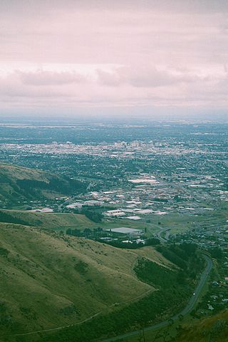
The Port Hills are a range of hills in Canterbury Region of New Zealand, so named because they lie between the city of Christchurch and its port at Lyttelton. They are an eroded remnant of the Lyttelton volcano, which erupted millions of years ago.

<span class="mw-page-title-main">Seddon, New Zealand</span> Town in Marlborough, New Zealand

Seddon is a small town in Marlborough, New Zealand. It is located 25 kilometres (16 mi) south of Blenheim, close to the mouths of the Awatere and Blind Rivers and the Lake Grassmere salt works.

<span class="mw-page-title-main">Addington, New Zealand</span> Suburb in Christchurch, New Zealand

Addington is a major suburb of Christchurch, New Zealand. It is sited 2.5 kilometres (1.6 mi) south-west of the city centre.

Whitewash Head is the name of the seaward clifftop on Scarborough Hill in Christchurch, Canterbury, New Zealand. Taylors Mistake Walkway between Sumner and Taylors Mistake goes past Whitewash Head. There is a spotted shag colony in the cliff below Whitewash Head.

<span class="mw-page-title-main">Bexley, New Zealand</span> Suburb in Christchurch, New Zealand

The suburb of Bexley is situated in East Christchurch on the west bank of the Avon River approximately one kilometre from the Avon Heathcote Estuary. It is enclosed within a bend in the Avon River and borders the suburb of Aranui.

<span class="mw-page-title-main">Redcliffs</span> Suburb in Christchurch, New Zealand

Redcliffs is an outer coastal suburb of Christchurch, Canterbury, New Zealand.

<span class="mw-page-title-main">Avondale, Christchurch</span> Suburb in Christchurch, New Zealand

Avondale is a suburb of Christchurch in the South Island of New Zealand. It is located 6 kilometres (3.7 mi) northeast of the city center, and is close to the Avon River, four kilometers to the northwest of its estuary. The suburb is centered on Avondale Road and so named due to its proximity to the Avon River. It has a good sized park on Mervyn Drive called Avondale Park. This park has a kids playground, a tennis court, basketball court, and a football field in winter. There is ample vacant red zone land in Avondale for activities such as leisure and dog walking.

<span class="mw-page-title-main">Mount Pleasant, New Zealand</span> Suburb in Christchurch, New Zealand

Mount Pleasant (Tauhinukorokio) is a coastal suburb of Christchurch, New Zealand. The suburb is located on the northern flank of the mountain Tauhinukorokio/Mount Pleasant in the Port Hills. It takes its name from the English version of the mountain's name.
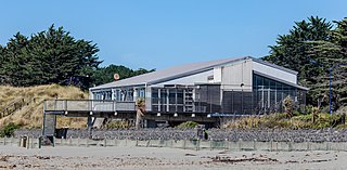
<span class="mw-page-title-main">Taylors Mistake</span> Suburb in Christchurch, New Zealand

Te Onepoto / Taylors Mistake is a locality in New Zealand's South Island, at the southeastern extremity of the city of Christchurch Taylors Mistake is a bay adjacent to the locality, on the north side of Awaroa / Godley Head, on the northern edge of Banks Peninsula.

<span class="mw-page-title-main">Brooklands, Christchurch</span> Suburb in Christchurch, New Zealand

Brooklands is the northernmost suburb of Christchurch, New Zealand. The settlement was built on former swamp land adjacent to Brooklands Lagoon, which forms part of the Waimakariri River mouth. The land damage sustained in the 2010 and 2011 Christchurch earthquakes and subsequent Red Zone classification resulted in the buyout and demolition of nearly all properties in Brooklands, effectively wiping the suburb off the map.

<span class="mw-page-title-main">Southshore, New Zealand</span> Suburb in Christchurch, New Zealand

Southshore is an eastern suburb within Christchurch, New Zealand. It is rich in wildlife and forestry. Although it was called Southshore informally for some years previously, it was named formally in 1955. The area was damaged in the 2011 Christchurch earthquake and 198 properties were zoned red.

<span class="mw-page-title-main">Tauhinukorokio / Mount Pleasant</span>

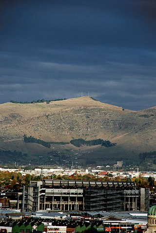
Tauhinukorokio / Mount Pleasant, also known just as either Mount Pleasant or Tauhinukorokio individually, is the highest elevation in the eastern Port Hills in Christchurch, New Zealand. It once held a Māori pā, but there was little left of it when European settlers first arrived in the 1840s. The hill was first used as a sheep run, and became the base trig station for the survey of Canterbury. It was also used as a signal station to make residents aware of ships coming into Lyttelton Harbour / Whakaraupō. During World War II, an extensive heavy anti-aircraft artillery (HAA) battery was built near the summit, and the foundations of those buildings still exist.

Clifton is a hillside suburb above Sumner in Christchurch, New Zealand.

<span class="mw-page-title-main">Richmond Hill, New Zealand</span> Suburb in Christchurch, New Zealand

Richmond Hill is a hillside suburb above Sumner in Christchurch, New Zealand.

St Andrews Hill is a hillside suburb in south-east Christchurch, New Zealand.

<span class="mw-page-title-main">Godley Head</span> Headland in New Zealand

Awaroa / Godley Head, called Cachalot Head by early French explorers, is a prominent headland in Christchurch, New Zealand, located at the entrance to Lyttelton Harbour / Whakaraupō. The headland is named for John Robert Godley.

<span class="mw-page-title-main">2016 Christchurch earthquake</span>

An earthquake occurred in Christchurch on 14 February 2016 at 1:13 p.m. local time and initially recorded as 5.9 on the Richter scale, but subsequently reviewed as 5.7. Often referred to as the Valentine's Day earthquake, it was centred in the sea off New Brighton at a depth of 15 kilometres (9.3 mi). It was the first large earthquake that the Christchurch area had experienced since May 2012, and it was part of the earthquake sequence that started with the 4 September 2010 Canterbury earthquake.

<span class="mw-page-title-main">Residential red zone</span> Unhabitable areas around Christchurch, New Zealand

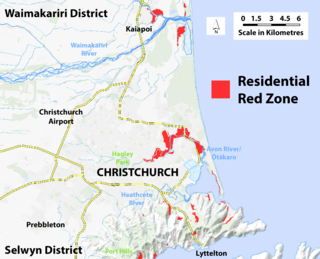
A residential red zone is any of several areas of land in and around Christchurch, New Zealand, that experienced severe damage in the 2010 and 2011 Christchurch earthquakes and were deemed infeasible to rebuild on. Through voluntary buyouts, the Crown acquired and demolished or removed over 8,000 properties. The majority were located in a broad swath of the eastern suburbs along the Avon River / Ōtākaro that had suffered damage from soil liquefaction.

References