Hillmorton, New Zealand

Last updated

Hillmorton
Sunny Side Asylum.jpg
Sunnyside Hospital, once the best-known institution of Hillmorton
Hillmorton, New Zealand
Coordinates: 43°33′19″S172°35′31″E / 43.555231°S 172.591994°E / -43.555231; 172.591994
CountryNew Zealand
City Christchurch
Local authority Christchurch City Council
Electoral ward
  • Halswell
  • Spreydon [1]
Community board
  • Waipuna Halswell-Hornby-Riccarton
  • Waihoro Spreydon-Cashmere-Heathcote
Area
[2]
  Land292 ha (722 acres)
Population
 (June 2022) [3]
  Total2,910
Hospital(s)Hillmorton Hospital
Middleton Addington
Wigram
Pfeil oben.svg
Pfeil links.svgHillmortonPfeil rechts.svg
Pfeil unten.svg
Spreydon
Aidanfield Hoon Hay

Hillmorton is a suburb of south-western Christchurch, New Zealand. The suburb is centred around the intersection of Lincoln Road and Hoon hay Road, two arterial routes which form part of State Highway 75 and feed into the Christchurch Southern Motorway which runs to the north of the suburb.

Contents

History

Hillmorton takes its name from Hill Morton Farm, the property of John Twigger, who settled in the area in 1863. [4] Land from the subdivision of this farm was advertised for sale in a local newspaper in 1879 as being "part of Twigger's property known as Hillmorton". [5] At the same time as Twigger settled the area, 1863 also saw the opening of the Sunnyside Hospital, Christchurch's first mental asylum. The buildings were constructed in a gothic style by architect John Campbell, and represented a shift in the approach to mental illness in the region. Where previously those with mental illnesses were held at Lyttelton Gaol, [6] the hospital was founded on the principles of moral management, providing a more supportive environment for patients. [7] Commitment to this approach varied throughout the hospital's existence, until it was closed in 1999 due to replacement by the neighbouring Hillmorton Hospital. The final buildings of the former Sunnyside Hospital were demolished in April 2007 to make way for additional housing, a move which was met with protest due to the architectural and cultural significance of the structures. [8] Hillmorton Hospital continues to act as a dedicated mental health facility for the city from nearby to the original Sunnyside location. [9]

St Martin's Anglican Church, Hillmorton, Christchurch St Martins Anglican Hillmorton.jpg
St Martin's Anglican Church, Hillmorton, Christchurch

In 1933, Hillmorton was also chosen as the site for a Carmelite monastery to be established as the order's first New Zealand presence. The monastery was originally founded in a pre-existing homestead in June 1933, with the first wing not being completed until four years later. This was followed by the addition of a subsequent wing in 1950, since which point the monastery has maintained their presence in the heart of Hillmorton. [10]

Geography

The Heathcote River (Ōpāwaho) River flows along the northern boundary of Hillmorton [11] which along with Curletts Road is the boundary with Wigram. Hillmorton also borders several other suburbs:

Aidanfield West of Templetons Road. (properties on Templetons Road are part of Hillmorton) [12]

Hoon Hay South of Halswell Road, except Coppell Place which is part of Hillmorton (properties on this section of Haslwell Road are part of Hillmorton) [12]

Spreydon South of Lincoln Road (properties on this section of Lincoln Road are part of Hillmorton) [12]

Addington West of Wrights Road (properties on Wrights Road are not part of Hillmorton) [12]

Middleton to the North, separated by the Christchurch Southern Motorway

Demographics

Hillmorton covers 2.92 km2 (1.13 sq mi). [2] It had an estimated population of 2,910 as of June 2022, [3] with a population density of 997 people per km2.

Historical population
YearPop.±% p.a.
20062,160    
20132,655+2.99%
20182,838+1.34%
Source: [13]

Hillmorton had a population of 2,838 at the 2018 New Zealand census, an increase of 183 people (6.9%) since the 2013 census, and an increase of 678 people (31.4%) since the 2006 census. There were 1,089 households, comprising 1,383 males and 1,455 females, giving a sex ratio of 0.95 males per female. The median age was 38.2 years (compared with 37.4 years nationally), with 483 people (17.0%) aged under 15 years, 570 (20.1%) aged 15 to 29, 1,323 (46.6%) aged 30 to 64, and 462 (16.3%) aged 65 or older.

Ethnicities were 77.1% European/Pākehā, 8.9% Māori, 3.8% Pasifika, 16.3% Asian, and 3.2% other ethnicities. People may identify with more than one ethnicity.

The percentage of people born overseas was 26.0, compared with 27.1% nationally.

Although some people chose not to answer the census's question about religious affiliation, 49.4% had no religion, 37.6% were Christian, 0.5% had Māori religious beliefs, 2.7% were Hindu, 0.5% were Muslim, 0.8% were Buddhist and 2.5% had other religions.

Of those at least 15 years old, 552 (23.4%) people had a bachelor's or higher degree, and 420 (17.8%) people had no formal qualifications. The median income was $35,300, compared with $31,800 nationally. 378 people (16.1%) earned over $70,000 compared to 17.2% nationally. The employment status of those at least 15 was that 1,260 (53.5%) people were employed full-time, 342 (14.5%) were part-time, and 63 (2.7%) were unemployed. [13]

Education

Hillmorton High School is a secondary school catering for years 7 to 13. [14] It had a roll of 1179 as of April 2023. [15] The school opened in 1961 as Hoon Hay Post Primary School. [16]

Southern Regional Health School is a special school. [17] It had a roll of 18 as of April 2023. [15] It provides education for children throughout the South Island who are too ill to attend a regular school. [18]

Related Research Articles

<span class="mw-page-title-main">Christchurch</span> City in the South Island of New Zealand

Christchurch is the largest city in the South Island of New Zealand and the seat of the Canterbury Region. Christchurch lies on the South Island's east coast, just north of Banks Peninsula on Pegasus Bay. The Avon River / Ōtākaro flows through the centre of the city, with an urban park along its banks. The city's territorial authority population is 396,200 people, and includes a number of smaller urban areas as well as rural areas. The population of the urban area is 384,800 people. Christchurch is the second-largest city by urban area population in New Zealand, after Auckland. It is the major urban area of an emerging sub-region known as Greater Christchurch. Notable smaller urban areas within this sub-region include Rangiora and Kaiapoi in Waimakariri District, north of the Waimakariri River, and Rolleston and Lincoln in Selwyn District to the south.

<span class="mw-page-title-main">Lyttelton, New Zealand</span> Settlement in Christchurch, New Zealand

Lyttelton is a port town on the north shore of Lyttelton Harbour / Whakaraupō, at the northwestern end of Banks Peninsula and close to Christchurch, on the eastern coast of the South Island of New Zealand.

<span class="mw-page-title-main">Ōpāwaho / Heathcote River</span> River in Christchurch, New Zealand

The Ōpāwaho / Heathcote River lies within the city boundaries of Christchurch, New Zealand, and is fed from springs near Templeton Road, with a catchment area in wet weather extending as far west as Yaldhurst and Pound Road. It meanders around the base of the Port Hills from west to south-east.

<span class="mw-page-title-main">Cashmere, New Zealand</span> Suburb of Christchurch, New Zealand

Cashmere is a suburb which rises above the southern end of the city of Christchurch in New Zealand's South Island.

<span class="mw-page-title-main">Sydenham, New Zealand</span> Suburb of Christchurch, New Zealand

Sydenham is an inner suburb of Christchurch, New Zealand, two kilometres south of the city centre, on and around the city's main street, Colombo Street. It is a residential, retail and light industrial suburb.

<span class="mw-page-title-main">Wigram</span> Suburb of Christchurch, New Zealand

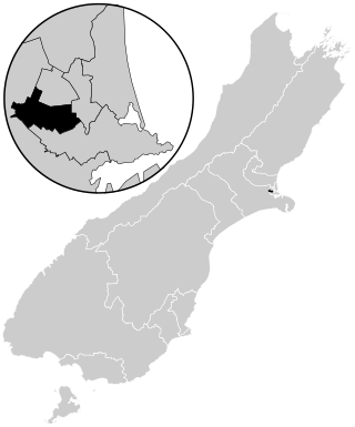
Wigram is a suburb in the southwest of Christchurch, New Zealand. The suburb lies close to the industrial estates of Sockburn and the satellite retail and residential zone of Hornby, and has undergone significant growth in recent years due to housing developments. It is seven kilometres to the west of the city centre.

<span class="mw-page-title-main">Rolleston, New Zealand</span> Town in the South Island of New Zealand

Rolleston is the seat and largest town in the Selwyn District, in the Canterbury region of New Zealand's South Island. It is located on the Canterbury Plains 22 kilometres (14 mi) south-west of Christchurch, and is part of the wider Christchurch metropolitan area. The town has a population of 29,600, making it New Zealand's 23rd-largest urban area and the second-largest in Canterbury.

<span class="mw-page-title-main">Bryndwr</span> Suburb of Christchurch, New Zealand

Bryndwr is a suburb in the north-west of Christchurch, New Zealand.

<span class="mw-page-title-main">Spreydon</span> Suburb of Christchurch, New Zealand

Spreydon is a suburb of Christchurch, New Zealand, 4 kilometres (2.5 mi) south-south-west of Cathedral Square. The most central street through Spreydon is Barrington Street. Spreydon is flanked by the suburbs Hoon Hay, Sydenham, and Lower Cashmere. State Highway 76 marks the northern boundary of the suburb, including the eastern end of the Christchurch Southern Motorway.

<span class="mw-page-title-main">Beckenham, New Zealand</span> Suburb of Christchurch, New Zealand

Beckenham is an inner suburb of Christchurch, New Zealand, located three kilometres south of the city centre. The Ōpāwaho / Heathcote River winds through this predominantly residential suburb, a section of which is often referred to locally as the "Beckenham Loop". Beckenham is bounded by Sydenham to the north, Somerfield to the west, Cashmere and Huntsbury to the south and St Martins to the east.

St Martins is an inner suburb of Christchurch, New Zealand, located two kilometres south of the city centre. Primarily a residential area, St Martins is host to a small shopping mall complex situated on Wilsons Road, the main thoroughfare through the suburb.

<span class="mw-page-title-main">Redcliffs</span> Suburb of Christchurch, New Zealand

Redcliffs is an outer coastal suburb of Christchurch, Canterbury, New Zealand.

<span class="mw-page-title-main">Wigram (New Zealand electorate)</span> Electoral district in Canterbury, New Zealand

Wigram is a New Zealand parliamentary electorate, returning one Member of Parliament to the New Zealand House of Representatives. The current MP for Wigram is Megan Woods of the Labour Party. She took over this position from Jim Anderton, who had held this position from 1996 until 2011.

<span class="mw-page-title-main">Sunnyside Hospital</span> Hospital in Canterbury Region, New Zealand

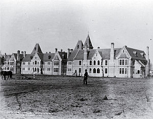
Sunnyside Hospital (1863–1999) was the first mental asylum to be built in Christchurch, New Zealand. It was initially known as Sunnyside Lunatic Asylum, and its first patients were 17 people who had previously been kept in the Lyttelton gaol. In 2007, Hilmorton Hospital is just one of the mental health services that are based on the old Sunnyside Hospital grounds.

<span class="mw-page-title-main">Strowan</span> Suburb of Christchurch, New Zealand

Strowan is an affluent suburb of Christchurch, New Zealand, located approximately 5 km north-west of Christchurch's central business district. It had a population of 3,705 at the 2013 census. It is located between the suburbs of Merivale, Papanui, Bryndwr, Fendalton, and St Albans.

Hoon Hay is an outer suburb of Christchurch, New Zealand, located at the base of the Port Hills and about 5 kilometres (3.1 mi) southwest of Cathedral Square. The area was named by Captain Wickham Talbot Harvey, a captain of the British Royal 10th Hussars, who moved to the area in 1852 and named it after the farm near Hatton, Derbyshire where he grew up. Harvey only stayed in the area for four years, before a fire destroyed his property and prompted him to return to the United Kingdom. Further fires in the following years destroyed the woodland which was on the property, including several large Tōtara, causing it to be converted into farmland. Remnants of this forest remain visible in the area, including with tree stumps being discovered during flood mitigation work on the Ōpāwaho / Heathcote River.

<span class="mw-page-title-main">Upper Riccarton</span> Suburb of Christchurch, New Zealand

Upper Riccarton is a suburb of Christchurch. It is due west of Riccarton.

Barrington is a minor suburb in the south of Christchurch, New Zealand, occasionally referred to as part of Spreydon. In 2006, the area was classified as a suburb by government organisations such as Statistics New Zealand for the purposes of the census, and divided into two areas named Barrington South and Barrington North. For the 2018 census, the area of Barrington was instead primarily included within the statistical area of Spreydon South.

<span class="mw-page-title-main">Canterbury District Health Board</span> District health board in New Zealand

The Canterbury District Health Board was a district health board with the focus on providing healthcare to the Canterbury region of New Zealand, north of the Rangitata River. It was responsible for roughly 579,000 residents, or 12% of New Zealand's population. The Canterbury District Health Board covered a territory of 26,881 square kilometers and was divided between six territorial local authorities. In July 2022, the Canterbury DHB was merged into the national health service Te Whatu Ora.

References

  1. "Wards, Councillors and Community Boards map". ccc.govt.nz. Christchurch City Council. Retrieved 14 August 2020.
  2. 1 2 "ArcGIS Web Application". statsnz.maps.arcgis.com. Retrieved 24 September 2021.
  3. 1 2 "Population estimate tables - NZ.Stat". Statistics New Zealand . Retrieved 25 October 2022.
  4. Harper, Margaret. "Christchurch Street Names: H" (PDF). Christchurch City Libraries. p. 95. Retrieved 31 May 2020.
  5. "Christchurch Place Names: A – M" (PDF). christchurchcitylibraries.com. Christchurch City Libraries. Retrieved 23 August 2020.
  6. Blake-Palmer, Geoffrey. 1966. 'Hospitals, Mental', In A. H. McLintock, ed., An Encyclopaedia of New Zealand. (Accessed 19 August 2007)
  7. Watson, Katharine. "Inside an asylum". Christchurch Uncovered. Underground Overground Archaeology. Retrieved 23 August 2020.
  8. "Sunnyside Hospital". my.christchurchcitylibraries.com. Christchurch City Libraries. Retrieved 23 August 2020.
  9. "Hillmorton Hospital". Hospital website. Retrieved 30 May 2020.
  10. "History". Carmelite Monastery of Christ the King Christchurch, New Zealand. Carmelite Monastery, Christchurch. Retrieved 23 August 2020.
  11. "2021-Community-Profiles-Spreydon-Ward.pdf" (PDF). Retrieved 16 June 2021.
  12. 1 2 3 4 "Address and Postcode Finder" . Retrieved 16 June 2021.
  13. 1 2 "Statistical area 1 dataset for 2018 Census". Statistics New Zealand. March 2020. Hillmorton (325000). 2018 Census place summary: Hillmorton
  14. Education Counts: Hillmorton High School
  15. 1 2 "New Zealand Schools Directory". New Zealand Ministry of Education. Retrieved 12 December 2022.
  16. "Miscellaneous Local Historical Information" (PDF). Christchurch City Libraries. p. 80. Retrieved 24 September 2021.
  17. Education Counts: Southern Regional Health School
  18. "Kia Ora! Welcome to the Southern Health School". Southern Regional Health School. Retrieved 24 September 2021.