Clifton, Christchurch

Last updated

Clifton
Sumner Head (left) with Rapanui Rock (right), Christchurch, New Zealand.jpg
Clifton (above the cliff) and Sumner Bay
Clifton, Christchurch
Coordinates: 43°33′S172°45′E / 43.550°S 172.750°E / -43.550; 172.750
CountryNew Zealand
City Christchurch
Local authority Christchurch City Council
Electoral wardHeathcote
Area
[1]
  Land256 ha (633 acres)
Population
 (June 2022) [2]
  Total1,800
Moncks Bay (Avon Heathcote Estuary)
Redcliffs
Pfeil oben.svg
Pfeil links.svgCliftonPfeil rechts.svg
Pfeil unten.svg
Port Hills Sumner

Clifton is a hillside suburb above Sumner in Christchurch, New Zealand.

Contents

Clifton is a volcanic spur extending from Tauhinukorokio / Mount Pleasant. [3] Most of Clifton was originally purchased by Dr Alfred Barker, who had applied for a 50 acres (20 ha) land grant from the Christchurch land office. Barker sold his land in 1872. [4] The lower part of Clifton was undeveloped until 1903, when it was subdivided into 93 sections and put up for auction, as far up the hill as Tuawera Terrace, which was originally known as Victoria Terrace. [5] The land further up the hill was subdivided in 1908. [5]

A lower side spur, originally known as Lower Clifton, was bought in 1901 by Samuel Hurst Seager. [6] Seager landscaped and divided the section into 12 plots and it was sold under the name The Spur in 1914. [7] It has been known as the Spur since. [6] [8] This area is the main residential hill area above Sumner. [9]

The ridge that Clifton lies upon, descends from Tauhinukorokio / Mount Pleasant to end in a coastal cliff at the western end of Sumner beach. The cliff overhangs the road between Sumner and Moncks Bay that has been built along the beach. This area by the beach is now known as Peacocks Gallop because John Thomas Peacock would gallop his horse when riding along this section of road on account of his fear of being hit by falling rocks. Earthquakes in 2011 and later in 2016 caused the cliff edge to collapse and recede so much that several clifftop houses were undermined and severely damaged, or left perched precariously on the cliff edge. Shipping containers were stacked two-high on the main road below to protect it from further rockfalls and these subsequently became an impromptu roadside art gallery.

Demographics

The Clifton Hill statistical area, which also includes Moncks Bay, covers 2.56 km2 (0.99 sq mi). [1] It had an estimated population of 1,800 as of June 2022, [2] with a population density of 703 people per km2.

Historical population
YearPop.±% p.a.
20061,851    
20131,479−3.15%
20181,647+2.18%
Source: [10]
Clifton Spur in 1920 Clifton Spur.jpg
Clifton Spur in 1920
Avon Heathcote Estuary from Clifton Hill Avon Heathcote Estuary from Clifton Hill 2019.jpg
Avon Heathcote Estuary from Clifton Hill

Clifton Hill had a population of 1,647 at the 2018 New Zealand census, an increase of 168 people (11.4%) since the 2013 census, and a decrease of 204 people (−11.0%) since the 2006 census. There were 624 households. There were 807 males and 837 females, giving a sex ratio of 0.96 males per female. The median age was 47.3 years (compared with 37.4 years nationally), with 276 people (16.8%) aged under 15 years, 222 (13.5%) aged 15 to 29, 810 (49.2%) aged 30 to 64, and 336 (20.4%) aged 65 or older.

Ethnicities were 96.2% European/Pākehā, 4.0% Māori, 0.4% Pacific peoples, 2.9% Asian, and 1.3% other ethnicities (totals add to more than 100% since people could identify with multiple ethnicities).

The proportion of people born overseas was 28.2%, compared with 27.1% nationally.

Although some people objected to giving their religion, 57.7% had no religion, 33.9% were Christian, 0.2% were Hindu, 0.4% were Buddhist and 2.0% had other religions.

Of those at least 15 years old, 624 (45.5%) people had a bachelor or higher degree, and 111 (8.1%) people had no formal qualifications. The median income was $47,900, compared with $31,800 nationally. The employment status of those at least 15 was that 687 (50.1%) people were employed full-time, 270 (19.7%) were part-time, and 36 (2.6%) were unemployed. [10]

Notes

  1. 1 2 "ArcGIS Web Application". statsnz.maps.arcgis.com. Retrieved 10 October 2021.
  2. 1 2 "Population estimate tables - NZ.Stat". Statistics New Zealand . Retrieved 25 October 2022.
  3. Ogilvie 2009, p. 56.
  4. Ogilvie 2009, pp. 59f.
  5. 1 2 Ogilvie 2009, p. 60.
  6. 1 2 Ogilvie 2009, pp. 58f.
  7. The Spur, Sumner: the property of S. Hurst Seager (PDF). Christchurch: Christchurch Press Printers. 1914.
  8. Lochhead, Ian J. "Samuel Hurst Seager". Dictionary of New Zealand Biography . Ministry for Culture and Heritage . Retrieved 23 April 2017.
  9. Ogilvie 2009, p. 59.
  10. 1 2 "Statistical area 1 dataset for 2018 Census". Statistics New Zealand. March 2020. Clifton Hill (332400). 2018 Census place summary: Clifton Hill

Related Research Articles

<span class="mw-page-title-main">Banks Peninsula</span> Peninsula south of Christchurch, New Zealand

<span class="mw-page-title-main">Sumner, New Zealand</span> Suburb in Christchurch, New Zealand

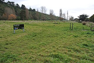
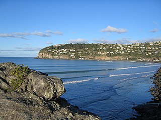
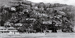
Sumner is a coastal seaside suburb of Christchurch, New Zealand and was surveyed and named in 1849 in honour of John Bird Sumner, the then newly appointed Archbishop of Canterbury and president of the Canterbury Association. Originally a separate borough, it was amalgamated with the city of Christchurch as communications improved and the economies of scale made small town boroughs uneconomic to operate.

<span class="mw-page-title-main">Port Hills</span> Range of hills of Canterbury, New Zealand

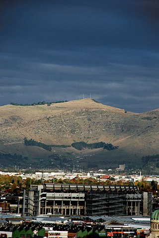
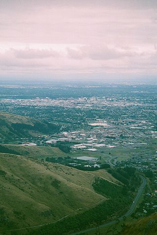
The Port Hills are a range of hills in Canterbury Region of New Zealand, so named because they lie between the city of Christchurch and its port at Lyttelton. They are an eroded remnant of the Lyttelton volcano, which erupted millions of years ago.

<span class="mw-page-title-main">Ferrymead</span> Suburb in Christchurch, New Zealand

Ferrymead is a suburb south-east of Christchurch, New Zealand. It is the main thoroughfare for reaching the eastern sea suburbs such as Sumner, as well as home to a number of cliff-top residences and businesses along the estuary front. After the 2011 Canterbury earthquake, a number of prominent Christchurch businesses relocated to the Ferrymead area, making it into a secondary business hub.

<span class="mw-page-title-main">Redcliffs</span> Suburb in Christchurch, New Zealand

Redcliffs is an outer coastal suburb of Christchurch, Canterbury, New Zealand.

<span class="mw-page-title-main">Port Hills (New Zealand electorate)</span> Former electorate in Canterbury, New Zealand

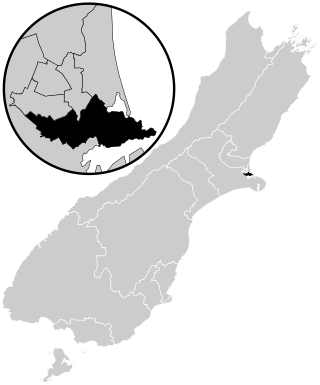
Port Hills was a parliamentary electorate of New Zealand that existed for the 2008 through 2017 general elections. Ruth Dyson of the Labour Party had previously held the Banks Peninsula electorate since the 1999 election that was largely replaced by Port Hills, and held Port Hills for its entire existence before retiring ahead of the 2020 election. The Port Hills electorate was mostly urban, and lost the more rural Banks Peninsula areas of the old electorate to the Selwyn electorate that was also formed for the 2008 election.

<span class="mw-page-title-main">Mount Pleasant, New Zealand</span> Suburb in Christchurch, New Zealand

Mount Pleasant (Tauhinukorokio) is a coastal suburb of Christchurch, New Zealand. The suburb is located on the northern flank of the mountain Tauhinukorokio/Mount Pleasant in the Port Hills. It takes its name from the English version of the mountain's name.

<span class="mw-page-title-main">St Clair, New Zealand</span> Suburb in Dunedin, New Zealand

St Clair is a leafy residential suburb of Dunedin, New Zealand. It is located on the Pacific Ocean coast five kilometres from the city centre on the southwesternmost part of the coastal plain which makes up the southern part of the urban area, and also climbs the slopes of Forbury Hill immediately to the west of this plain. St Clair's 2001 population was 4,179.

<span class="mw-page-title-main">Sign of the Kiwi</span>

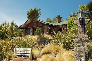
The Sign of the Kiwi, originally called Toll House, is a small café and shop at Dyers Pass on the road between Christchurch and Governors Bay. It was built in 1916–17 by Harry Ell as a staging post and opened as a tearoom and rest house. It has a Category I heritage classification by Heritage New Zealand and is a popular destination for tourists and locals alike. The building was closed some time after the 22 February 2011 Christchurch earthquake and did not open again until 23 January 2017, six years later. Although located within the burned area, the building was not damaged by the 2017 Port Hills fires a month later.

<span class="mw-page-title-main">Samuel Hurst Seager</span> New Zealand builder, draftsman, architect, town planner, photographer (1885–1933)

Samuel Hurst Seager was a notable New Zealand builder, draftsman, architect and town planner. He was born in London, England, in 1855, and as a boy emigrated to Christchurch, New Zealand, with his parents in 1870.

<span class="mw-page-title-main">Tauhinukorokio / Mount Pleasant</span>

Tauhinukorokio / Mount Pleasant, also known just as either Mount Pleasant or Tauhinukorokio individually, is the highest elevation in the eastern Port Hills in Christchurch, New Zealand. It once held a Māori pā, but there was little left of it when European settlers first arrived in the 1840s. The hill was first used as a sheep run, and became the base trig station for the survey of Canterbury. It was also used as a signal station to make residents aware of ships coming into Lyttelton Harbour / Whakaraupō. During World War II, an extensive heavy anti-aircraft artillery (HAA) battery was built near the summit, and the foundations of those buildings still exist.

<span class="mw-page-title-main">Hillsborough, Christchurch</span> Suburb in Christchurch, New Zealand

Hillsborough is a mixed industrial and residential suburb of Christchurch, New Zealand, located approximately 4 kilometres (2.5 mi) to the south-east of the city centre.

<span class="mw-page-title-main">Kennedys Bush</span> Suburb in Christchurch, New Zealand

Kennedys Bush is a south-western suburb of Christchurch, New Zealand.

<span class="mw-page-title-main">Moncks Bay</span> Suburb in Christchurch, New Zealand

Moncks Bay is a south-eastern suburb of Christchurch, New Zealand.

<span class="mw-page-title-main">Richmond Hill, New Zealand</span> Suburb in Christchurch, New Zealand

Richmond Hill is a hillside suburb above Sumner in Christchurch, New Zealand.

<span class="mw-page-title-main">Scarborough, New Zealand</span> Suburb in Christchurch, New Zealand

Scarborough is a hillside suburb above Sumner in Christchurch, New Zealand.

<span class="mw-page-title-main">The Spur</span> Collection of interconnected arts and crafts bungalows in Clifton, Christchurch, New Zealand

The Spur is a collection of interconnected Arts and Crafts bungalows in Clifton, Christchurch.

<span class="mw-page-title-main">Waimairi Beach</span> Suburb in Christchurch, New Zealand

Waimairi Beach is a suburb of Christchurch, New Zealand. It is located north-east of the city. It is east of Parklands and north of North New Brighton. The word "waimairi" translates to "listless stream".

<span class="mw-page-title-main">Durie Hill</span> Suburb of Whanganui

Durie Hill is a suburb of Whanganui, in the Whanganui District and Manawatū-Whanganui region of New Zealand's North Island.

<span class="mw-page-title-main">North New Brighton</span> Suburb in Christchurch, New Zealand

North New Brighton is a suburb on the northern side of Christchurch city. It was originally known as North Beach and was readily accessible from Christchurch city by tram. It was renamed North New Brighton in 1953.

References