Purau | |
---|---|
Coordinates: 43°38′30.44″S172°45′8.23″E / 43.6417889°S 172.7522861°E | |
Country | New Zealand |
Region | Canterbury Region |
District | Christchurch City |
Ward | Banks Peninsula |
Community | Te Pātaka o Rākaihautū Banks Peninsula |
Electorates |
|
Government | |
• Territorial Authority | Christchurch City Council |
• Regional council | Environment Canterbury |
• Mayor of Christchurch | Phil Mauger |
• Banks Peninsula MP | Vanessa Weenink |
• Te Tai Tonga MP | Tākuta Ferris |
Area | |
• Total | 0.21 km2 (0.08 sq mi) |
Population (June 2022) [2] | |
• Total | 70 |
• Density | 330/km2 (860/sq mi) |
Purau is a small town in Canterbury, New Zealand, facing Lyttelton Harbour.
Purau is located on Banks Peninsula, one of the southern bays forming Lyttelton Harbour.
Purau has a long history of Māori settlement. Ngāti Māmoe lived here prior to Ngāi Tahu settling the bay. There are many Māori burial sites in the area. [3]
European occupation started in 1843, when the Greenwood brothers started a farm here. They sold to the Rhodes brothers in 1847 (William Barnard and George, with the latter taking over management of the station). [4] [5] When Robert Heaton Rhodes, another of the Rhodes brothers, came to New Zealand in 1850, he took over Purau. [6]
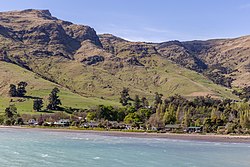
Purau is described by Statistics New Zealand as a rural settlement, and covers 0.21 km2 (0.081 sq mi). [1] It had an estimated population of 70 as of June 2022 with a population density of 333 people per km2. It was part of the Eastern Bays-Banks Peninsula SA2 statistical area in 2018, [7] and part of Diamond Harbour in 2023. [8]
Year | Pop. | ±% p.a. |
---|---|---|
2006 | 63 | — |
2013 | 51 | −2.97% |
2018 | 69 | +6.23% |
Source: [9] |
Purau had a population of 69 at the 2018 New Zealand census, an increase of 18 people (35.3%) since the 2013 census, and an increase of 6 people (9.5%) since the 2006 census. There were 33 households, comprising 33 males and 33 females, giving a sex ratio of 1.0 males per female. The median age was 52.5 years (compared with 37.4 years nationally), with 9 people (13.0%) aged under 15 years, 6 (8.7%) aged 15 to 29, 39 (56.5%) aged 30 to 64, and 15 (21.7%) aged 65 or older.
Ethnicities were 95.7% European/Pākehā, 13.0% Māori, and 4.3% Pasifika. People may identify with more than one ethnicity.
Although some people chose not to answer the census's question about religious affiliation, 47.8% had no religion, 26.1% were Christian and 4.3% had other religions.
Of those at least 15 years old, 18 (30.0%) people had a bachelor's or higher degree, and 6 (10.0%) people had no formal qualifications. The median income was $32,500, compared with $31,800 nationally. 9 people (15.0%) earned over $70,000 compared to 17.2% nationally. The employment status of those at least 15 was that 27 (45.0%) people were employed full-time, 12 (20.0%) were part-time, and 3 (5.0%) were unemployed. [9]
Coromandel, also called Coromandel Town to distinguish it from the wider district, is a town on the Coromandel Harbour, on the western side of the Coromandel Peninsula, which is in the North Island of New Zealand. It is 75 kilometres east of the city of Auckland, although the road between them, which winds around the Firth of Thames and Hauraki Gulf coasts, is 190 km long. The population was 1,930 as of June 2023.
Lyttelton is a port town on the north shore of Lyttelton Harbour / Whakaraupō, at the northwestern end of Banks Peninsula and close to Christchurch, on the eastern coast of the South Island of New Zealand.
The Far North District is the northernmost territorial authority district of New Zealand, consisting of the northern part of the Northland Peninsula in the North Island. It stretches from North Cape / Otou and Cape Reinga / Te Rerenga Wairua in the north, down to the Bay of Islands, the Hokianga and the town of Kaikohe.
Whangateau is a small town on the east coast of the North Island of New Zealand. It is situated in Rodney District, part of the Auckland Region, and is on a peninsula stretching out into the Hauraki Gulf, north of Auckland. Whangateau is on the northern shore of Whangateau Harbour which is fed by the Ōmaha River and separated from Ōmaha Bay by the Maungatawhiri sandspit. The settlement is in two parts of 20 to 30 houses each. The main settlement includes a large public reserve with sports fields and a campground. There is also a public hall which hosts music events and a flax weaving group. The smaller settlement is Tram Car Bay, named for two tram cars which were used as holiday homes. Whangateau is situated between the rural settlement of Matakana and the fishing village of Leigh. A tsunami siren is located in the town.
Dunsandel is a small rural town in the Canterbury region of the South Island, New Zealand. The town is located on the Canterbury Plains just south of the Selwyn River / Waikirikiri and about 40 km south of Christchurch. Dunsandel is a junction town on SH1, halfway between Christchurch and Ashburton, with roads leading to Leeston, Southbridge and Hororata. The town provides an important refreshment stop for main road travellers with eateries and coffee shops, as well as acting as a support town for the rural hinterland.
Pukenui is a locality on the southwest side of Houhora Harbour on the Aupouri Peninsula of Northland, New Zealand. State Highway 1 runs through it. The name means "large hill" in the Māori language.
Whangarei District is a territorial authority district in the Northland Region of New Zealand that is governed by the Whangarei District Council. The district is made up in area largely by rural land, and includes a fifth of the Northland Region. It extends southwards to the southern end of Bream Bay, northwards to Whangaruru and almost to the Bay of Islands, and westwards up the Mangakahia River valley past Pakotai and almost to Waipoua Forest. It includes the Hen and Chicken Islands and the Poor Knights Islands.
Duvauchelle Bay is a small town situated at the head of Akaroa Harbour on Banks Peninsula in New Zealand. State Highway 75 passes through the town. The Onawe Peninsula separates Duvauchelle bay from Barry's Bay.
Matarangi is a beach settlement on the Coromandel Peninsula of New Zealand, with around 420 permanent residents in 2018 which increases to over 7000 holidaymakers during the summer period of late December to February. It was developed in the 1980s as a purpose-built resort town and occupies a white sand peninsula between the Whangapoua Harbour and historic Mercury Bay. It is half an hour from the towns of Coromandel to the west and Whitianga to the south east.
Port Albert is situated on the shores of the Kaipara Harbour, approximately 8 kilometres west of Wellsford, in the Auckland Region of New Zealand. Originally called Albertland, it was the last of the major organised British settlements in New Zealand.
Timaru District is a local government district on New Zealand's South Island, administered by the Timaru District Council. It is part of the larger Canterbury Region. Timaru district was formed in 1989 from the amalgamation of Timaru City, Geraldine district, Temuka district and Stratham district.
Takamatua, with an initial European name of German Bay, is a small town situated in Akaroa Harbour on Banks Peninsula in New Zealand. The main road to Akaroa passes through this locality. It is 3 kilometres (1.9 mi) north of Akaroa township.
Teddington is a very small community on Banks Peninsula at the head of Lyttelton Harbour / Whakaraupō. It sits on the junction of the road to Gebbies Pass and the road from Purau to Christchurch.
Shelly Beach, officially known as Aotea / Shelly Beach, is a settlement and beach located on the eastern side of Te Korowai-o-Te-Tonga Peninsula and the southwest side of Kaipara Harbour, North Auckland. In 2018, a seawall and five groynes were constructed to fight erosion.
Tokerau Beach is a settlement on the northwestern side of Doubtless Bay on the Karikari Peninsula of Northland, New Zealand.
Te Hana is a small town on State Highway 1 near the northern boundary of Auckland. Wellsford is 5 km (3.1 mi) to the south, and Kaiwaka is 15 km (9.3 mi) northeast. Te Hana Creek runs westward on the northern end of the town to the Kaipara Harbour.
Point Wells is a rural settlement in the Auckland Region of New Zealand, at the tip of a peninsula between the Ōmaha River and Whangateau Harbour. Ōmaha is across the harbour but accessible by a causeway.
Scotts Landing, also called Mahurangi East, is a rural settlement in the Auckland Region of New Zealand. It is at the end of a narrow peninsula on the eastern side of Mahurangi Harbour. Algies Bay is to the north.
Matakawau Point is a rural settlement on the east side of the Āwhitu Peninsula and west side of the Manukau Harbour in the Auckland Region of New Zealand. The mouth of Matakawau Creek is south of Matakawau Point.
Thornton Bay is a settlement on the west coast of the Coromandel Peninsula of New Zealand, between Te Puru to the north and Whakatete Bay to the south. State Highway 25 runs through it. Ngarimu Bay immediately to the south is considered to be part of the same urban area by Statistics New Zealand.