
The Ōpāwaho / Heathcote River lies within the city boundaries of Christchurch, New Zealand, and is fed from springs near Templeton Road, with a catchment area in wet weather extending as far west as Yaldhurst and Pound Road. It meanders around the base of the Port Hills from west to south-east.
Cashmere is a suburb which rises above the southern end of the city of Christchurch in New Zealand's South Island.

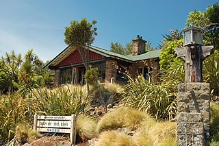
The Sign of the Takahe is a neo-Gothic style historic building in Christchurch, New Zealand. It is currently leased from Christchurch City Council and run as a cafe, bar, and function centre.

Princess Margaret Hospital is a public hospital in Christchurch, New Zealand. It is run by the Canterbury District Health Board.
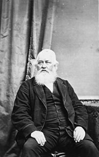
Sir John Cracroft Wilson, also known as Nabob Wilson, was a British-educated civil servant in India, farmer and politician in New Zealand.
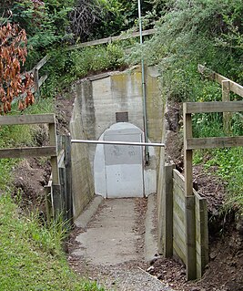
Cracroft Caverns, also known as the Cashmere Caverns, are a series of large chambers in the hill of the Cashmere suburb of Christchurch, New Zealand.

The Addington Railway Workshops was a major railway workshops established in the Christchurch suburb of Addington in 1877 by the Public Works Department, and transferred in 1880 to the newly-formed New Zealand Railways Department (NZR). The workshops closed in 1990.

The Latin Rite Roman Catholic Diocese of Christchurch is a suffragan diocese of the Roman Catholic Archdiocese of Wellington. Its cathedral and see city are located in Christchurch, the largest city in the South Island of New Zealand. It was formed on 5 May 1887 from a portion of the territory of the Diocese of Wellington, which was elevated to archdiocese later that same month.

Christchurch City Libraries is operated by the Christchurch City Council and is a network of 21 libraries and a mobile book bus. Following the 2011 Christchurch earthquake the previous Christchurch Central Library building was demolished, and was replaced by a new central library building in Cathedral Square, Tūranga, which opened in 2018.

Travis Wetland is a wetland in the suburb of Burwood in Christchurch, New Zealand. An ecological restoration programme is being undertaken to restore the wetland. It covers 116 ha of land formerly drained and used as a dairy farm. In 2009 it won the "Urban Sustainability" category in the Green Ribbon Awards awarded by the Minister for the Environment.

The Halswell River is a river in the Canterbury region of New Zealand.
Heathcote was a 19th-century parliamentary electorate in Christchurch, New Zealand.

William Barbour Wilson, also known as Cabbage Wilson, was the first Mayor of Christchurch in New Zealand in 1868. A nurseryman by profession, he had large landholdings in Christchurch. His reputation was dented by a fraud conviction, and when he was subsequently elected onto the city council once more, five councillors resigned in protest.

John Anderson was the second Mayor of Christchurch in New Zealand 1868–1869, and a successful businessman. He had a close connection with three buildings that have later received Category I heritage registrations by Heritage New Zealand. Two of these buildings were demolished following the February 2011 Christchurch earthquake.
St Andrews Hill is a hillside suburb in south-east Christchurch, New Zealand.

The Hornby Clocktower was an iconic Christchurch building, situated in the suburb of Hornby on New Zealand State Highway 1. It marked the southern entrance to Christchurch for over 50 years.

Cracroft Reserve is a 3.2 hectare public reserve on Cracroft Hill in the Cashmere suburb of Christchurch, New Zealand. It is situated next to the Sign of the Takahe. Cracroft Reserve is a popular stop for tourists, and residents, with its viewing platform at 200 metres (660 ft) elevation providing panoramic views of Christchurch city, the Canterbury Plains, and the Southern Alps. The main entrance to the reserve is from the southern end of Hackthorne Road.

Riccarton House is an historic building in Christchurch, New Zealand. It is part of the Riccarton estate, the first area in Christchurch lived in by white settlers, after which the suburb of Riccarton is named. The house was commissioned by Jane Deans, the widow of Canterbury pioneer John Deans, and finished in 1856. It was twice extended; first in 1874, and the work carried out in 1900 more than doubled the size of the house. The Riccarton estate has in stages become the property of Christchurch City Council and Riccarton House itself was sold by the Deans family to the city in 1947. Damaged by the earthquakes in 2010 and 2011, the repaired and renovated building was reopened in June 2014. Riccarton House is used as a restaurant and for functions, and a popular market is held on Saturdays in front of it.

The Four Avenues are a group of four major arterial boulevards — Bealey Avenue, Fitzgerald Avenue, Moorhouse Avenue, and Deans Avenue — which surround the city centre of Christchurch, New Zealand. Serving as an inner ring road, they popularly form the limits of the city centre, separating it from the city's suburbs. Almost all of the city's commercial heart lies within the approximately rectangular 9.8-square-kilometre (3.8 sq mi) area formed by the four avenues. The term "within the Four Avenues" is widely used in Christchurch to refer to the central city. By extension, Christchurch as a whole is sometimes referred to as "The Four Avenues".
