Burnside is a suburb of Christchurch, New Zealand, located southeast of Christchurch International Airport. As with most suburbs in Christchurch, it has no defined boundaries and is a general area.
Burnside was originally part of a farm, approximately 1,700 acres (6.9km2) in size, owned by the early settler William Boag (1828–1904), who arrived in 1851 from Perthshire. It was named for the small creeks that formed the headwaters of the Waimairi Stream.[3][4] The name Burnside was made official by the Waimairi County Council in 1959,[5] although Burnside Road had been renamed Memorial Avenue in 1950.[6]
For the first hundred years of European settlement, the area in and around Burnside was farmland, with sheep, cattle and orchards occupying the land.[citation needed]
Demographics
Burnside, comprising the statistical areas of Burnside, Burnside Park and Russley, covers 4.57km2 (1.76sqmi).[1] It had an estimated population of 9,420 as of June 2023, with a population density of 2,061 people per km2.
Burnside had a population of 7,713 at the 2018 New Zealand census, an increase of 378 people (5.2%) since the 2013 census, and an increase of 522 people (7.3%) since the 2006 census. There were 2,712 households, comprising 3,810 males and 3,903 females, giving a sex ratio of 0.98 males per female, with 1,458 people (18.9%) aged under 15 years, 1,683 (21.8%) aged 15 to 29, 3,372 (43.7%) aged 30 to 64, and 1,200 (15.6%) aged 65 or older.
Ethnicities were 70.2% European/Pākehā, 7.2% Māori, 2.9% Pasifika, 24.6% Asian, and 3.1% other ethnicities. People may identify with more than one ethnicity.
The percentage of people born overseas was 32.6, compared with 27.1% nationally.
Although some people chose not to answer the census's question about religious affiliation, 47.9% had no religion, 39.1% were Christian, 0.2% had Māori religious beliefs, 1.4% were Hindu, 1.6% were Muslim, 2.0% were Buddhist and 2.1% had other religions.
Of those at least 15 years old, 1,788 (28.6%) people had a bachelor's or higher degree, and 780 (12.5%) people had no formal qualifications. 1,185 people (18.9%) earned over $70,000 compared to 17.2% nationally. The employment status of those at least 15 was that 3,024 (48.3%) people were employed full-time, 1,023 (16.4%) were part-time, and 219 (3.5%) were unemployed.[7]
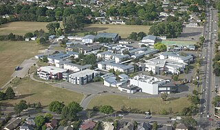
Burnside High School is a secondary school catering for years 9 to 13.[11] It has a roll of 2,439. The school opened in 1960.[12]
Cobham Intermediate is an intermediate school catering for years 7 to 8.[13] It has a roll of 631. The school, initially named Fendalton Intermediate, opened in 1963.[14]
Burnside Primary School and Roydvale School are contributing primary schools catering for years 1 to 6.[15][16] They have rolls of 298 and 269, respectively. Burnside School opened in 1956, and Roydvale in 1967.[3] Kendal School, which opened in 1962,[3] closed in 2014.[17]
Christ the King School is a state-integrated Catholic primary school for years 1 to 8.[18] It has a roll of 308.
All these schools are coeducational, and all except Christ the King are state schools. Rolls are as of February 2024.[19]
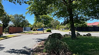
Suburb
Burnside contains a central park (Burnside Park), and its two central roads are Memorial Avenue and Greers Road. It contains a smaller park (Jellie Park) opposite Burnside High School on Greers Road.
Related Research Articles
Darfield is a town in the Selwyn District of the South Island of New Zealand. It is 35 kilometres west of Christchurch. Its population is 3,150 as of June 2023.
Mairehau is a suburb of Christchurch, New Zealand. It is located four kilometres north of the city centre, close to the edge of the urbanised central city area. Much new development is being carried out on the northern edge of Mairehau.
Belfast is a suburb of Christchurch, New Zealand. It is in the north of the city 10 km from Cathedral Square, close to the banks of the Waimakariri River.
Fendalton is a suburb of Christchurch, in the South Island of New Zealand.
Bryndwr is a suburb in the north-west of Christchurch, New Zealand.
Cobham Intermediate School is a state intermediate school in the northwestern Christchurch, New Zealand suburb of Burnside.
Redwood is a northern suburb of Christchurch, New Zealand which includes the sub-division of Redwood Springs. It is bordered by the Styx River to the north.
Burnside High School is a state co-educational secondary school located in the suburb of Burnside in Christchurch, New Zealand. With a roll of 2,439 students, it is the largest school in New Zealand outside Auckland, and is among the country's four largest schools.
Bishopdale is a residential suburb located in the north of Christchurch, New Zealand.
Burwood is a north-eastern suburb of Christchurch, New Zealand. The suburb is mostly a residential area and is centred on Burwood Hospital, Travis Wetland Nature Heritage Park and Bottle Lake Forest.
Ilam is a New Zealand parliamentary electorate. Formed for the 1996 election, it was held by Gerry Brownlee of the National Party until the 2020 election, when Sarah Pallett of the Labour Party unseated Brownlee in an upset victory. The seat reverted to National when it was won by Hamish Campbell in the 2023 election.
Strowan is an affluent suburb of Christchurch, New Zealand, located approximately 5 km north-west of Christchurch's central business district. It had a population of 3,705 at the 2013 census. It is located between the suburbs of Merivale, Papanui, Bryndwr, Fendalton, and St Albans.
Avondale is a suburb of Christchurch in the South Island of New Zealand. It is located 6 kilometres (3.7 mi) northeast of the city center, and is close to the Avon River / Ōtākaro, four kilometres to the northwest of its estuary. The suburb is centred on Avondale Road and so named due to its proximity to the Avon River. It has a good sized park on Mervyn Drive called Avondale Park. This park has a kids playground, a tennis court, basketball court, and a football field in winter. There is ample vacant red zone land in Avondale for activities such as leisure and dog walking.
Avonhead is a suburb of the New Zealand city of Christchurch. It has two primary schools, a shopping centre and several parks.
Parklands is a suburb of Christchurch, New Zealand. It is located north east of the city centre near Bottle Lake Forest.
Hei Hei is a suburb of Christchurch, New Zealand. It is located in the west of Christchurch 11 kilometres (6.8 mi) from the central city, and is bisected by State Highway 1. The area was subdivided for poultry farming after World War I for returning serviceman, but the venture failed due to the poor soil conditions. The place name is related to the Māori word for chicken (heihei) due to the area's poultry farming history.
Waimairi Beach is a suburb of Christchurch, New Zealand. It is located north-east of the city. It is east of Parklands and north of North New Brighton. The word "waimairi" translates to "listless stream".
Casebrook is a suburb on the northern side of Christchurch city.
Russley is a suburb on the western side of Christchurch city.
This page is based on this Wikipedia article Text is available under the CC BY-SA 4.0 license; additional terms may apply. Images, videos and audio are available under their respective licenses.