Wainoni, Christchurch

Last updated

Wainoni
Aerial image of Christchurch suburbs - Flickr - NZ Defence Force (1).jpg
Aerial view of Porritt Park after the February 2011 Christchurch earthquake, showing extensive soil liquefaction
Wainoni, Christchurch
Coordinates: 43°31′0″S172°41′30″E / 43.51667°S 172.69167°E / -43.51667; 172.69167
CountryNew Zealand
City Christchurch
Local authority Christchurch City Council
Electoral ward
  • Burwood
  • Linwood
Community board Waitai Coastal-Burwood-Linwood
Area
[1]
  Land152 ha (376 acres)
Population
 (June 2023) [2]
  Total2,850
(Residential red zone) Avondale Aranui
Avonside
Pfeil oben.svg
Pfeil links.svgWainoniPfeil rechts.svg
Pfeil unten.svg
Bexley
Linwood Bromley

Wainoni is one of the eastern suburbs of Christchurch. It is a lower socio-economic area. [3]

Contents

Etymology

Wainoni is a Māori word, with wai meaning stream and noni meaning a bend or turn. [4] The name was applied by Alexander William Bickerton to his new home on the Avon River. [5]

History

Annual gala at Wainoni Park, 1914 Annual gala at Wainoni Park, 1914.jpg
Annual gala at Wainoni Park, 1914

In 1884, Bickerton and his family moved into a new home near New Brighton, Christchurch that he named Wainoni. [5] Bickerton, who purchased a 30 acres (12 ha) property around what is now Bickerton Street, [6] accepted, in 1874, the post of foundation professor of Chemistry at Canterbury College. [7] It became a centre for the social life of students at the Canterbury College. The property included a small theatre, a vast garden, and fireworks displays for entertainment. Bickerton's idea for the property was to create a new form of society based around his socialist beliefs, [8] however this social experiment was discontinued after several years. [5] From 1903 the property was turned more into a theme park to provide family income, with a zoo, 7,000 person amphitheatre, conservatory, aquariums, cinema, medicine and fireworks factories, and mock naval battles on a man-made lake. It attracted hundreds of thousands of people over the coming years. In the end the Pleasure Gardens, as they were called, started running at a loss and was closed by 1914. [5]

The suburb developed for housing during the 1960s. [4] [9]

Geography

Porritt Park, an old loop of the Avon River, lies within Wainoni. Going clockwise from there, boundary roads of the suburb are Wainoni, Breezes, Pages, and Kerrs Roads. [3] [10] Wainoni is approximately 7 kilometres (4.3 mi) from the central city. [3] Wainoni Park is located in the adjacent suburb of Aranui.

Wainoni and its neighbouring suburb of Aranui are often considered together and intermixed. For example, Wainoni School and Wainoni Park are located in Aranui, and the now closed Aranui High School was located in Wainoni. Christchurch City Council publishes a combined community profile for the two suburbs. [3]

Demographics

Wainoni covers 1.52 km2 (0.59 sq mi). [1] It had an estimated population of 2,850 as of June 2023, [2] with a population density of 1,875 people per km2.

Historical population
YearPop.±% p.a.
20062,859    
20132,694−0.85%
20182,799+0.77%
Source: [11]

Wainoni had a population of 2,799 at the 2018 New Zealand census, an increase of 105 people (3.9%) since the 2013 census, and a decrease of 60 people (−2.1%) since the 2006 census. There were 1,029 households, comprising 1,410 males and 1,386 females, giving a sex ratio of 1.02 males per female. The median age was 36.0 years (compared with 37.4 years nationally), with 552 people (19.7%) aged under 15 years, 591 (21.1%) aged 15 to 29, 1,305 (46.6%) aged 30 to 64, and 351 (12.5%) aged 65 or older.

Ethnicities were 78.6% European/Pākehā, 19.8% Māori, 9.5% Pasifika, 7.8% Asian, and 2.1% other ethnicities. People may identify with more than one ethnicity.

The percentage of people born overseas was 16.2, compared with 27.1% nationally.

Although some people chose not to answer the census's question about religious affiliation, 53.1% had no religion, 33.1% were Christian, 1.5% had Māori religious beliefs, 1.3% were Hindu, 0.8% were Muslim, 0.4% were Buddhist and 2.7% had other religions.

Of those at least 15 years old, 213 (9.5%) people had a bachelor's or higher degree, and 585 (26.0%) people had no formal qualifications. The median income was $27,600, compared with $31,800 nationally. 162 people (7.2%) earned over $70,000 compared to 17.2% nationally. The employment status of those at least 15 was that 1,092 (48.6%) people were employed full-time, 345 (15.4%) were part-time, and 105 (4.7%) were unemployed. [11]

Education

Haeata Community Campus is a coeducational composite school for years 1 to 13 [12] with a roll of 536 students as of February 2024. [13] It was created by merging Aranui School (primary school located in Aranui), Avondale School (primary school located in the neighbouring Avondale), Wainoni School (primary school in Aranui) and Aranui High School on the Aranui High site in January 2017. [14]

Related Research Articles

<span class="mw-page-title-main">Belfast, New Zealand</span> Suburb of Christchurch, New Zealand

Belfast is a suburb of Christchurch, New Zealand. It is in the north of the city 10 km from Cathedral Square, close to the banks of the Waimakariri River.

<span class="mw-page-title-main">Opawa</span> Suburb of Christchurch, New Zealand

Opawa is an inner suburb of Christchurch, New Zealand. It is sited approximately 3.5 kilometres south-east of the city centre. The Māori name for the area is "Ōpāwaho", there was a Māori fortified settlement sited near the present-day Vincent Place and Judge Street intersection. Many early European settlers in Opawa were of English descent, many of whom came from relatively wealthy families. The area became a rural-agricultural locality and a few homesteads were established in the area. The suburb was heavily urbanised after Woolston's industrialisation. Opawa is part of the Christchurch Central parliamentary electorate.

<span class="mw-page-title-main">Riccarton, New Zealand</span> Suburb of Christchurch, New Zealand

Riccarton is a suburb of Christchurch. It is due west of the city centre, separated from it by Hagley Park. Upper Riccarton is to the west of Riccarton.

<span class="mw-page-title-main">Ilam, New Zealand</span> Suburb of Christchurch, New Zealand

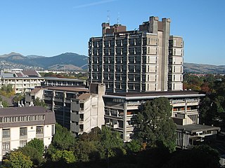
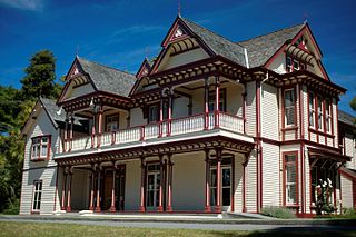
Ilam is a suburb of Christchurch, New Zealand about five kilometres west of the city centre. It is the location of the University of Canterbury.

<span class="mw-page-title-main">Heathcote Valley</span> Suburb of Christchurch, New Zealand

Heathcote Valley is a suburb of Christchurch, New Zealand. It is named after Sir William Heathcote, who was secretary of the Canterbury Association.

<span class="mw-page-title-main">Addington, New Zealand</span> Suburb of Christchurch, New Zealand

Addington is one of the older suburbs of Christchurch, New Zealand. It was originally open grassland with patches of shrubland which soon became a working-class suburb which was heavily industrialised with factories and large premises of railway workshops built along Main South Line. It is sited 2.5 kilometres (1.6 mi) south-west of the city centre.

<span class="mw-page-title-main">Avonside</span> Suburb of Christchurch, New Zealand

Avonside is an eastern suburb in Christchurch, New Zealand. It is one of the oldest suburbs of the city, with only Heathcote being older.

<span class="mw-page-title-main">New Windsor, New Zealand</span> Suburb in Auckland, New Zealand

New Windsor, founded in 1865, is a suburb of Auckland, New Zealand. It is located 10 kilometres (6.2 mi) from the Auckland city centre, between Mount Albert, Blockhouse Bay, Mt Roskill and Avondale.

<span class="mw-page-title-main">St Albans, New Zealand</span> Suburb of Christchurch, New Zealand

St Albans is a large, inner-northern suburb of Christchurch, New Zealand, located directly north of the Christchurch Central Business District. It is the second largest suburb in the city by population, with a population of 13,137 at the 2018 Census. The suburb falls within the Christchurch Central electorate and is represented by Duncan Webb, who has been the member of parliament since the 2017 general election. St Albans is one of the most diverse residential neighbourhoods in Christchurch, with a wide range of densities, architectural styles and housing ages throughout the suburb. It has everything from run-down high-density council-owned flats, to modern luxurious high-density flats and apartments; old mid-density workers cottages through to large low-density estates of various ages.

Aranui High School was a large secondary school for years 9–13, in Christchurch, New Zealand. Aranui high school took its name from the suburb of Aranui, meaning 'big pathway' in Māori. Aranui High School was a coeducational alternative to other secondary schools in Eastern Christchurch such as Linwood College and Mairehau High School.

<span class="mw-page-title-main">Beckenham, New Zealand</span> Suburb of Christchurch, New Zealand

Beckenham is an inner suburb of Christchurch, New Zealand, located three kilometres south of the city centre. The Ōpāwaho / Heathcote River winds through this predominantly residential suburb, a section of which is often referred to locally as the "Beckenham Loop". Beckenham is bounded by Sydenham to the north, Somerfield to the west, Cashmere and Huntsbury to the south and St Martins to the east.

<span class="mw-page-title-main">Bexley, New Zealand</span> Suburb of Christchurch, New Zealand

The suburb of Bexley is situated in East Christchurch on the west bank of the Avon River / Ōtākaro approximately one kilometre from the Avon Heathcote Estuary. It is enclosed within a bend in the Avon River and borders the suburb of Aranui.

<span class="mw-page-title-main">Redcliffs</span> Suburb of Christchurch, New Zealand

Redcliffs is an outer coastal suburb of Christchurch, Canterbury, New Zealand.

<span class="mw-page-title-main">Avondale, Christchurch</span> Suburb of Christchurch, New Zealand

Avondale is a suburb of Christchurch in the South Island of New Zealand. It is located 6 kilometres (3.7 mi) northeast of the city center, and is close to the Avon River / Ōtākaro, four kilometres to the northwest of its estuary. The suburb is centred on Avondale Road and so named due to its proximity to the Avon River. It has a good sized park on Mervyn Drive called Avondale Park. This park has a kids playground, a tennis court, basketball court, and a football field in winter. There is ample vacant red zone land in Avondale for activities such as leisure and dog walking.

<span class="mw-page-title-main">Aranui</span> Suburb of Christchurch, New Zealand

Aranui is one of the eastern suburbs of Christchurch. It is a lower socio-economic area. In its early years, Aranui grew along Pages Road, the suburb's main road. Aranui soon became a working and lower-class suburb. There are also areas of light-industrial premises in Aranui. The suburb grew rapidly between 1945 and 1951. The area is predominantly residential with pockets of light industry. There are shops and service facilities at the intersection of Breezes Road and Pages Road and a smaller retail precinct centred on Hampshire Street. Aranui is part of the Christchurch East parliamentary electorate.

<span class="mw-page-title-main">Aidanfield</span> Suburb of Christchurch, New Zealand

Aidanfield is a suburb in the south-west of Christchurch, New Zealand, about 8 kilometres (5.0 mi) from the city centre. The land, which had been owned by the Good Shepherd Sisters since 1886, now incorporates the Mount Magdala Institute and the St John of God Chapel, which has a Category I heritage listing by the New Zealand Historic Places Trust. The first residents moved into the suburb in 2002. The developer caused controversy in 2007–2008 by applying to have a group of farm buildings demolished to allow for further subdivision. Christchurch City Council was widely criticised for approving the demolition despite the buildings having had a heritage listing in the Christchurch City Plan.

<span class="mw-page-title-main">Southshore, New Zealand</span> Suburb of Christchurch, New Zealand

Southshore is an eastern coastal suburb within Christchurch, New Zealand. It is sited on a narrow 2.5 km (1.6 mi) long sandspit that runs along the eastern side of the Avon Heathcote Estuary. The suburb is 8 km (5.0 mi) eastwards from the city centre and 5 km (3.1 mi) south from New Brighton's main retail area. Before urbanisation, the area was predominantly swampland, bordered by large sand dunes which had some Māori presence. The area holds historical and cultural importance to local Māori iwi because of the large amounts of resources and seafood gathered in the area prior to European occupation.

<span class="mw-page-title-main">South New Brighton</span> Suburb of Christchurch, New Zealand

South New Brighton is a coastal suburb on the eastern side of Christchurch city.

<span class="mw-page-title-main">Marshland, New Zealand</span> Suburb of Christchurch, New Zealand

Marshland is a semi-rural suburb on the northern side of Christchurch city. The land is primarily used for horticulture and dairy farming.

<span class="mw-page-title-main">North New Brighton</span> Suburb of Christchurch, New Zealand

North New Brighton is a suburb on the northern side of Christchurch city. It was originally known as North Beach and was readily accessible from Christchurch city by tram. It was renamed North New Brighton in 1953.

References

Commons-logo.svg Media related to Wainoni, Canterbury at Wikimedia Commons

  1. 1 2 "ArcGIS Web Application". statsnz.maps.arcgis.com. Archived from the original on 24 March 2023. Retrieved 5 January 2024.
  2. 1 2 "Population estimate tables - NZ.Stat". Statistics New Zealand . Retrieved 25 October 2023.
  3. 1 2 3 4 "Community profile Aranui/Wainoni" (PDF). Christchurch City Council. Archived from the original (PDF) on 7 October 2013. Retrieved 5 October 2013.
  4. 1 2 Harper, Margaret. "Christchurch Place Names N to Z" (PDF). Christchurch City Libraries. p. 104. Archived (PDF) from the original on 20 October 2016. Retrieved 5 October 2013.
  5. 1 2 3 4 Baker, Tim (2004). Professor Bickerton's Wainoni. Christchurch: Self-published. ISBN   0-476-00423-3.
  6. "Professor Bickerton's home and the promenade, from the Wainoni entrance". Christchurch City Libraries. Archived from the original on 12 October 2013. Retrieved 5 October 2013.
  7. Parton, H. N. "Bickerton, Alexander William". Dictionary of New Zealand Biography . Ministry for Culture and Heritage . Retrieved 5 October 2013.
  8. "Wainoni". Star. No. 7330. 17 February 1902. p. 4. Archived from the original on 21 October 2013. Retrieved 5 October 2013.
  9. Montgomery, Roy (21 March 2016). "State Intervention in a Post-War Suburban Public Housing Project in Christchurch, New Zealand". Articulo – Journal of Urban Research. 13/2016 (13): 38. doi: 10.4000/articulo.2932 . hdl: 10182/7804 .
  10. "Boundary Map of Chisnall". Statistics New Zealand. Archived from the original on 12 October 2013. Retrieved 5 October 2013.
  11. 1 2 "Statistical area 1 dataset for 2018 Census". Statistics New Zealand. March 2020. Wainoni (328400). 2018 Census place summary: Wainoni
  12. Education Counts: Haeata Community Campus
  13. "New Zealand Schools Directory". New Zealand Ministry of Education. Retrieved 14 March 2024.
  14. "Eight Chch schools merge into two". 3 News NZ. 11 September 2013. Archived from the original on 30 September 2021. Retrieved 30 September 2021.