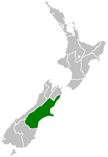
Canterbury is a region of New Zealand, located in the central-eastern South Island. The region covers an area of 44,508 square kilometres (17,185 sq mi), and is home to a population of 645,900.

Christchurch is the largest city in the South Island of New Zealand and the seat of the Canterbury Region. The Christchurch urban area lies on the South Island's east coast, just north of Banks Peninsula. The urban area is home to 383,200 residents, and the territorial authority has 394,700 people, which makes it the second-most populous city in New Zealand after Auckland and before Wellington. The Avon River flows through the centre of the city, with an urban park located along its banks.

Lyttelton is a port town on the north shore of Lyttelton Harbour, at the northwestern end of Banks Peninsula and close to Christchurch, on the eastern coast of the South Island of New Zealand. According to the 2013 census, Lyttelton had a usual resident population of 2,859.
Avonside is an eastern suburb in Christchurch, New Zealand. It is one of the oldest suburbs of the city, with only Heathcote being older.
Redcliffs is an outer coastal suburb of Christchurch, Canterbury, New Zealand.

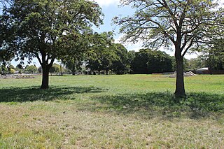
Avondale is a suburb of Christchurch in the South Island of New Zealand. It is located 6 kilometres (3.7 mi) northeast of the city center, and is close to the Avon River, four kilometers to the northwest of its estuary. The suburb is centered on Avondale Road and so named due to its proximity to the Avon River. It has a good sized park on Mervyn Drive called Avondale Park. This park has a kids playground, a tennis court, basketball court, and a football field in winter. There is ample vacant red zone land in Avondale for activities such as leisure and dog walking.
Dallington is a suburb of Christchurch, New Zealand, on the north-east side of the city.

Orion New Zealand Limited (Orion) is an electricity distribution company, based in Christchurch, New Zealand.

The Avon River / Ōtākaro flows through the centre of the city of Christchurch, New Zealand, and out to an estuary, which it shares with the Heathcote River, the Avon Heathcote Estuary.

Christchurch Central City or Christchurch City Centre is the geographical centre and the heart of Christchurch, New Zealand. It is defined as the area within the four avenues and thus includes the densely built up central city, some less dense surrounding areas of residential, educational and industrial usage, and green space including Hagley Park, the Christchurch Botanic Gardens and the Barbadoes Street Cemetery.

The 2010 Canterbury earthquake struck the South Island of New Zealand with a moment magnitude of 7.1 at on 4 September, and had a maximum perceived intensity of X (Extreme) on the Mercalli intensity scale. Some damaging aftershocks followed the main event, the strongest of which was a magnitude 6.3 shock known as the Christchurch earthquake that occurred nearly six months later on 22 February 2011. Because this aftershock was centred very close to Christchurch, it was much more destructive and resulted in the deaths of 185 people.

A 6.2 earthquake occurred in Christchurch on Tuesday 22 February 2011 at 12:51 p.m. local time. The earthquake struck the Canterbury region in New Zealand's South Island and was centred 6.7 kilometres (4.2 mi) south-east of the centre of Christchurch, New Zealand's second-most populous city. The earthquake caused widespread damage across Christchurch, killing 185 people in the nation's fifth-deadliest disaster.

Aranui is one of the eastern suburbs of Christchurch. It is a lower socio-economic area. The area is predominantly residential with pockets of light industry. There is a cluster of shops and service facilities at the intersection of Breezes Road and Pages Road.

The June 2011 Christchurch earthquake was a shallow magnitude 6.0 earthquake that occurred on 13 June 2011 at 14:20 NZST. It was centred at a depth of 7 km (4.3 mi), about 5 km (3 mi) south-east of Christchurch, which had previously been devastated by a magnitude 6.2 MW earthquake in February 2011. The June quake was preceded by a magnitude 5.9 ML tremor that struck the region at a slightly deeper 8.9 km (5.5 mi). The United States Geological Survey reported a magnitude of 6.0 Mw and a depth of 9 km (5.6 mi).
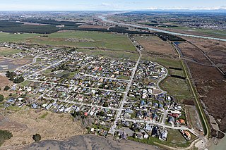
Brooklands is the northernmost suburb of Christchurch, New Zealand. The settlement was built on former swamp land adjacent to Brooklands Lagoon, which forms part of the Waimakariri River mouth. The land damage sustained in the 2010 and 2011 Christchurch earthquakes and subsequent Red Zone classification resulted in the buyout and demolition of nearly all properties in Brooklands, effectively wiping the suburb off the map.

The Central City Red Zone, also known as the CBD Red Zone, was a public exclusion zone in the Christchurch Central City implemented after the 22 February 2011 Christchurch earthquake. After February 2013, it was officially renamed the CBD Rebuild Zone by government agencies, but remained known as the Red Zone. It gradually shrank in size and the last cordons were removed on 30 June 2013, 859 days after the earthquake.

Wainoni is one of the eastern suburbs of Christchurch. It is a lower socio-economic area.
The 1863 Hawke's Bay earthquake was a devastating magnitude 7.5 earthquake that struck near the town of Waipukurau on 23 February 1863. It remained the single largest earthquake to strike Hawke's Bay until 1931, where a magnitude 7.8 quake leveled much of Napier and Hastings and killed 256 people.

An earthquake occurred in Christchurch on 14 February 2016 at 1:13 p.m. local time and initially recorded as 5.9 on the Richter scale, but subsequently reviewed as 5.7. Often referred to as the Valentine's Day earthquake, it was centred in the sea off New Brighton at a depth of 15 kilometres (9.3 mi). It was the first large earthquake that the Christchurch area had experienced since May 2012, and it was part of the earthquake sequence that started with the 4 September 2010 Canterbury earthquake.
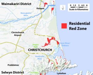
The residential red zone refers to areas of land in and around Christchurch, New Zealand, that experienced severe damage in the 2010 and 2011 Christchurch earthquakes and were deemed infeasible to rebuild on. Through voluntary buyouts, the Crown acquired and demolished or removed over 8,000 properties. The majority were located in a broad swath of the eastern suburbs along the Avon River / Ōtākaro that had suffered damage from soil liquefaction.

