
Canterbury is a region of New Zealand, located in the central-eastern South Island. The region covers an area of 44,503.88 square kilometres (17,183.04 sq mi), making it the largest region in the country by area. It is home to a population of 694,400.

Cheviot is a town in the Hurunui District of north Canterbury, on the east coast of the South Island of New Zealand. It is located on State Highway 1, approximately 112 kilometres (70 mi) north of Christchurch and 68 kilometres (42 mi) south of Kaikōura.

Soil liquefaction occurs when a cohesionless saturated or partially saturated soil substantially loses strength and stiffness in response to an applied stress such as shaking during an earthquake or other sudden change in stress condition, in which material that is ordinarily a solid behaves like a liquid. In soil mechanics, the term "liquefied" was first used by Allen Hazen in reference to the 1918 failure of the Calaveras Dam in California. He described the mechanism of flow liquefaction of the embankment dam as:
If the pressure of the water in the pores is great enough to carry all the load, it will have the effect of holding the particles apart and of producing a condition that is practically equivalent to that of quicksand... the initial movement of some part of the material might result in accumulating pressure, first on one point, and then on another, successively, as the early points of concentration were liquefied.

Christchurch is the largest city in the South Island and the second-largest city by urban area population in New Zealand. Christchurch has an urban population of 415,100, and a metropolitan population of over half a million. It is located in the Canterbury Region, near the centre of the east coast of the South Island, east of the Canterbury Plains. It is located near the southern end of Pegasus Bay, and is bounded to the east by the Pacific Ocean and to the south by the ancient volcanic complex of the Banks Peninsula. The Avon River (Ōtākaro) winds through the centre of the city, with a large urban park along its banks. With the exception of the Port Hills, it is a relatively flat city, on an average around 20 m (66 ft) above sea level. Christchurch has a reputation for being an English city, with its architectural identity and nickname the 'Garden City' due to similarities with garden cities in England, but also has a historic Māori heritage. Christchurch has a temperate oceanic climate with regular moderate rainfall.

Kaiapoi is a town in the Waimakariri District of the Canterbury region, in the South Island of New Zealand. The town is located approximately 17 kilometres north of central Christchurch, close to the mouth of the Waimakariri River. It is considered a satellite town of Christchurch and is part of the Christchurch functional urban area. The town is named after the nearby Kaiapoi Pā.

Rangiora is the largest town and seat of the Waimakariri District, in Canterbury, New Zealand. It is 29 kilometres (18 mi) north of Christchurch, and is part of the Christchurch metropolitan area. With an estimated population of 19,400, Rangiora is the 30th largest urban area in New Zealand, and the fifth-largest in the Canterbury region.
The 2nd New Zealand Parliament was a term of the Parliament of New Zealand. It opened on 15 April 1856, following New Zealand's 1855 election. It was dissolved on 5 November 1860 in preparation for 1860–61 election. The 2nd Parliament was the first under which New Zealand had responsible government, meaning that unlike previously, the Cabinet was chosen by Parliament rather than by the Governor-General of New Zealand.
Avonside is an eastern suburb in Christchurch, New Zealand. It is one of the oldest suburbs of the city, with only Heathcote being older.
The history of the Canterbury Region of the South Island of New Zealand dates back to settlement by Māori people in about the 14th century.
Waikuku is a small town in the Canterbury region of New Zealand, which sits 28 km north of central Christchurch. Waikuku lies 11.8 km (7.3 mi) south of Leithfield on state highway 1 and 3 km (1.9 mi) north of Woodend. In 1901 there were 86 people resident in Waikuku according to that year's census. Waikuku settlement had a population of 156 people at the time of the 2018 Census. It is popular with both those that commute into work in Christchurch each day and with owners of holiday houses. Waikuku was home to rope and twine works. This business started off using flax from local swamps. It closed in 1987. The nearby sandy beach and pine forests are popular with surfers, swimmers, campers and horse-riders, and the large estuary of the Ashley River hosts many species of birds.
The 2010 Canterbury earthquake struck the South Island of New Zealand with a moment magnitude of 7.1 at on 4 September, and had a maximum perceived intensity of X (Extreme) on the Mercalli intensity scale. Some damaging aftershocks followed the main event, the strongest of which was a magnitude 6.3 shock known as the Christchurch earthquake that occurred nearly six months later on 22 February 2011. Because this aftershock was centred very close to Christchurch, it was much more destructive and resulted in the deaths of 185 people.
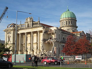
A major earthquake occurred in Christchurch on Tuesday 22 February 2011 at 12:51 p.m. local time. The 6.2 earthquake struck the Canterbury region in the South Island, centred 6.7 kilometres (4.2 mi) south-east of the central business district. It caused widespread damage across Christchurch, killing 185 people in New Zealand's fifth-deadliest disaster. Scientists classified it as an intraplate earthquake and a potential aftershock of the September 2010 Canterbury earthquake.

The Barbadoes Street Cemetery is the oldest cemetery in Christchurch, New Zealand. It was set up with three discrete areas for different denominations.

Southshore is an eastern coastal suburb within Christchurch, New Zealand. It is located on a narrow 2.5 km (1.6 mi) long sandspit that runs along the eastern side of the Avon Heathcote Estuary and west of the Pacific Ocean. The suburb is 8 km (5.0 mi) east of the city centre and 5 km (3.1 mi) south of New Brighton's main retail area.
The 1904 Cape Turnagain earthquake struck 10 kilometres (6.2 mi) north of Cape Turnagain on the morning of 9 August with a magnitude estimated at 6.8 and 7.0–7.2 . It was felt throughout the North Island and upper South Island, with many communities within a 500 kilometres (310 mi) radius reporting noticeable ground shaking. Heavy damage occurred to the landscape and personal property and one man died. It was the largest to strike New Zealand since the 7.0 Mw North Canterbury earthquake in 1888.
Robert William England was a New Zealand architect from Christchurch.
The 2003 Fiordland earthquake struck the remote region of Fiordland in the South Island of New Zealand on 22 August 2003, at 12:12 am NZST. The epicentre was 12 kilometres (7.5 mi) deep, and was thought to be near Secretary Island at the entrance to Doubtful Sound. At 7.2 Ms magnitude, it was one of the largest quakes in the country for some time, and was the largest shallow quake since the 1968 Inangahua earthquake. There was an aftershock two hours later at 2:12 am, followed over several days by frequent small tremors; two months after the earthquake, there had been 8,000 aftershocks.
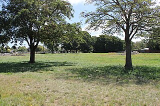
A residential red zone is any of several areas of land in and around Christchurch, New Zealand, that experienced severe damage in the 2010 and 2011 Christchurch earthquakes and were deemed infeasible to rebuild on. Through voluntary buyouts, the Crown acquired and demolished or removed over 8,000 properties. The majority were located in a broad swath of the eastern suburbs along the Avon River / Ōtākaro that had suffered damage from soil liquefaction.
NZS 3604 Timber-framed buildings is a New Zealand technical standard which sets out specifications and methods for designing and constructing light timber-framed houses and other low-rise buildings. When read together with the amendments in Building Code acceptable solution B1/AS1, it allows the construction of code-compliant buildings up to three storeys high on good ground without the need for specific structural engineering. The standard is maintained by Standards New Zealand.
Christchurch is a major city in the Canterbury Region, and is the largest city in the South Island of New Zealand. With a Māori history stemming back to the thirteenth century as the domain of the historic Waitaha iwi, Christchurch was constituted as a colonial outpost of the British Empire in 1850. Today Christchurch is the second largest city in New Zealand, after Auckland, with a metropolitan population of over half a million.


