The Virginia Seismic Zone in the U.S. state of Virginia covers about 8,000 square kilometers (3,100 sq mi) in the Piedmont province. Earthquakes in the state are irregular and rarely reach over 4.5 in magnitude.
The 1959 Hebgen Lake earthquake occurred in the western United States on August 17 at 11:37 pm (MST) in southwestern Montana.

The 2010 Baja California earthquake occurred on April 4 with a moment magnitude of 7.2 and a maximum Mercalli intensity of VII. The shock originated at south of Guadalupe Victoria, Baja California, Mexico.
The 2010 Canterbury earthquake struck the South Island of New Zealand with a moment magnitude of 7.1 at on 4 September, and had a maximum perceived intensity of X (Extreme) on the Mercalli intensity scale. Some damaging aftershocks followed the main event, the strongest of which was a magnitude 6.3 shock known as the Christchurch earthquake that occurred nearly six months later on 22 February 2011. Because this aftershock was centred very close to Christchurch, it was much more destructive and resulted in the deaths of 185 people.
The 2011 Kütahya earthquake struck near a populous region of western Turkey at 23:15 EEST (20:15 UTC) on 19 May with a moment magnitude of 5.8 and a maximum Mercalli intensity of VII. With an epicenter just to the east of Simav, it occurred at an estimated depth of 9.1 kilometers (5.7 mi), resulting in strong shaking in much of Kütahya.

The June 2011 Christchurch earthquake was a shallow magnitude 6.0 earthquake that occurred on 13 June 2011 at 14:20 NZST. It was centred at a depth of 7 km (4.3 mi), about 5 km (3 mi) south-east of Christchurch, which had previously been devastated by a magnitude 6.2 MW earthquake in February 2011. The June quake was preceded by a magnitude 5.9 ML tremor that struck the region at a slightly deeper 8.9 km (5.5 mi). The United States Geological Survey reported a magnitude of 6.0 Mw and a depth of 9 km (5.6 mi).

The 2011 Oklahoma earthquake was a 5.7 magnitude intraplate earthquake which occurred near Prague, Oklahoma on November 5 at 10:53 p.m. CDT in the U.S. state of Oklahoma. The epicenter of the earthquake was in the vicinity of several active wastewater injection wells. According to the United States Geological Survey (USGS), it was the most powerful earthquake ever recorded in Oklahoma; this record was surpassed by the 2016 Oklahoma earthquake. The previous record was a 5.5 magnitude earthquake that struck near the town of El Reno in 1952. The quake's epicenter was approximately 44 miles (71 km) east-northeast of Oklahoma City, near the town of Sparks and was felt in the neighboring states of Texas, Arkansas, Kansas and Missouri and even as far away as Tennessee and Wisconsin. The quake followed several minor quakes earlier in the day, including a 4.7 magnitude foreshock. The quake had a maximum perceived intensity of VIII (Severe) on the Mercalli intensity scale in the area closest to the epicenter. Numerous aftershocks were detected after the main quake, with a few registering at 4.0 magnitude.

The Oklahoma earthquake swarms are an ongoing series of human activity-induced earthquakes affecting central Oklahoma, southern Kansas, northern Texas since 2009. Beginning in 2009, the frequency of earthquakes in the U.S. state of Oklahoma rapidly increased from an average of fewer than two 3.0+ magnitude earthquakes per year since 1978 to hundreds each year in the 2014–17 period. Thousands of earthquakes have occurred in Oklahoma and surrounding areas in southern Kansas and North Texas since 2009. Scientific studies attribute the rise in earthquakes to the disposal of wastewater produced during oil extraction that has been injected more deeply into the ground.

The 2017 Batangas earthquakes were an earthquake swarm that occurred from early April to mid-August 2017, affecting the province of Batangas in the Philippines and other nearby areas.
The 2019 Ridgecrest earthquakes of July 4 and 5 occurred north and northeast of the town of Ridgecrest, California located in Kern County and west of Searles Valley. They included three initial main shocks of magnitudes 6.4, 5.4, and 7.1, and many perceptible aftershocks, mainly within the area of the Naval Air Weapons Station China Lake. Eleven months later, a Mw 5.5 aftershock took place to the east of Ridgecrest. The first main shock occurred on Thursday, July 4 at 10:33 a.m. PDT, approximately 18 km (11.2 mi) ENE of Ridgecrest, and 13 km (8.1 mi) WSW of Trona, on a previously unnoticed NE-SW trending fault where it intersects the NW-SE trending Little Lake Fault Zone. This quake was preceded by several smaller earthquakes, and was followed by more than 1,400 detected aftershocks. The M 5.4 and M 7.1 quakes struck on Friday, July 5 at 4:08 a.m. and 8:19 p.m. PDT approximately 10 km (6 miles) to the northwest. The latter, now considered the mainshock, was the most powerful earthquake to occur in the state in 20 years. Subsequent aftershocks extended approximately 50 km (~30 miles) along the Little Lake Fault Zone.
The 2019 Cotabato earthquakes were an earthquake swarm which struck the province of Cotabato on the island of Mindanao in the Philippines in October 2019. Three of these earthquakes were above 6.0 on the moment magnitude scale with a Mercalli intensity of VIII. More than 40 people have been reported dead or missing and nearly 800 were injured as a result of these events.
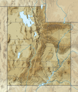
The 1992 St. George earthquake was a 5.8 earthquake that occurred on September 2, 1992 at approximately 4:26 AM MDT along the Washington Fault zone near the larger Hurricane Fault about 5 miles (8.0 km) southeast of St. George in Utah, United States. The quake triggered a landslide that destroyed three houses and caused approximately US$1 million in structural and cosmetic damage to houses, roads, natural formations, and utilities. No people were killed by the quake.
The 2020 Central Idaho earthquake occurred in the western United States on March 31, 2020, at 5:52 PM MDT, near Ruffneck Peak in the Sawtooth Mountains of central Idaho, 72 miles (116 km) northeast of Boise and 19 miles (31 km) northwest of Stanley. It had a magnitude of 6.5 and was felt with a maximum intensity of VIII.
The 1921 Sevier Valley earthquake was a series of three earthquakes. The primary quake was a magnitude 6.3 earthquake that occurred on Thursday, 29 September 1921 at approximately 7:12 AM MT in Elsinore, Utah, United States. The first aftershock occurred in the evening on the same day, and a second aftershock occurred two days later on 1 October. No people were killed in the quake or in the subsequent aftershocks.
The 1962 Cache Valley earthquake was a magnitude 5.9 earthquake that occurred on Thursday, 30 August 1962 at approximately 6:35 AM MT north of Richmond, Utah, United States, at the border between Utah and Idaho. No people were killed in the quake. The quake caused between US $1–2 million in damage.
An earthquake struck near the Hawaiian island of Lanai on February 19, at 10:11 pm HST with an estimated magnitude of 7.5 on the moment magnitude scale (Mw ). It remains one of the largest seismic event to hit the Hawaiian Islands since the 1868 Ka‘ū earthquake, with its effects being felt throughout the entire archipelago. It caused severe damage on the islands of Lanai, Molokai and Maui. A tsunami may have been generated however there are speculations if it had actually happened. Despite the size of the quake and the extent of damage, there were no deaths.
On February 7, 2021, at 12:22 PM PST, an earthquake measuring Mw 6.0 struck Davao del Sur and Cotabato. The event registered a Modified Mercalli Intensity Scale (MMI) of VIII (Severe) with VII on the PHIVOLCS Earthquake Intensity Scale (PEIS).
The 1870 Charlevoix earthquake occurred on 20 October in the Canadian province of Quebec. It had a moment magnitude of 6.6 Mw and a Modified Mercalli intensity rating of X (Extreme). The town of Baie-Saint-Paul was seriously damaged by the event, with the loss of six lives. Effects from the earthquake were felt as far as Virginia and along the New England coast of the United States.