Elsinore, Utah

Last updated
Elsinore, Utah
White Rock Schoolhouse Elsinore Utah.jpeg
Elsinore's old White Rock Schoolhouse
Nickname: 
Little Denmark
Sevier County Utah incorporated and unincorporated areas Elsinore highlighted.svg
Location in Sevier County and the state of Utah.
Coordinates: 38°41′4″N112°8′51″W / 38.68444°N 112.14750°W / 38.68444; -112.14750 [1]
Country United States
State Utah
County Sevier
Settled1874
Named for Elsinore
Area
[2]
  Total1.33 sq mi (3.46 km2)
  Land1.33 sq mi (3.46 km2)
  Water0.00 sq mi (0.00 km2)
Elevation
5,351 ft (1,631 m)
Population
 (2010)
  Total847
  Estimate 
(2019) [3]
882
  Density660.67/sq mi (255.01/km2)
Time zone UTC-7 (Mountain (MST))
  Summer (DST) UTC-6 (MDT)
ZIP code
84724
Area code 435
FIPS code 49-22650 [4]
GNIS feature ID1440921 [5]

Elsinore is a town in Sevier County, Utah, United States. The population was 847 at the 2010 census.

Contents

History

The community was first settled in the spring of 1874 by James C. Jensen, Jens Iver Jensen, and others. The area was settled by Danish converts to the Church of Jesus Christ of Latter-day Saints, and named after Kronborg Castle, known as Elsinore in Hamlet . [6] [7] Helsingør, the city where Kronborg Castle is located, is classically known as Elsinore as well.

The first passenger train arrived on 21 July 1896 from the Denver & Rio Grande Railroad.

Elsinore was home to a Utah-Idaho Sugar Company factory for processing sugar beets into sugar from 1911 to 1929, but was closed due to a sugar beet blight. [6]

On September 29 and October 1, 1921, Elsinore was hit by a series of magnitude six earthquakes. [8] Some buildings were damaged, and residents were frightened from their homes, but no deaths were reported.

Geography

According to the United States Census Bureau, the town has a total area of 1.3 square miles (3.3 km2), all land.

Demographics

Historical population
CensusPop.Note
1880 223
1890 590164.6%
1900 6255.9%
1910 6565.0%
1920 84328.5%
1930 654−22.4%
1940 6743.1%
1950 657−2.5%
1960 483−26.5%
1970 357−26.1%
1980 61271.4%
1990 608−0.7%
2000 73320.6%
2010 84715.6%
2019 (est.)882 [3] 4.1%
U.S. Decennial Census [9]

As of the census [4] of 2000, there were 733 people, 261 households, and 196 families residing in the town. The population density was 581.8 people per square mile (224.6/km2). There were 287 housing units at an average density of 227.8 per square mile (87.9/km2). The racial makeup of the town was 95.50% White, 0.14% African American, 1.36% Native American, 0.27% Asian, 0.95% from other races, and 1.77% from two or more races. Hispanic or Latino of any race were 2.59% of the population.

There were 261 households, out of which 40.6% had children under 18 living with them, 59.8% were married couples living together, 13.0% had a female householder with no husband present, and 24.9% were non-families. 23.4% of all households were made up of individuals, and 13.4% had someone living alone who was 65 years or older. The average household size was 2.81, and the average family size was 3.33.

In the town, the population was spread out, with 33.4% under 18, 10.4% from 18 to 24, 23.2% from 25 to 44, 19.6% from 45 to 64, and 13.4% who were 65 years of age or older. The median age was 30 years. For every 100 females, there were 88.9 males. For every 100 females aged 18 and over, there were 85.6 males.

The median income for a household in the town was $27,917, and the median income for a family was $36,250. Males had a median income of $30,208 versus $16,705 for females. The per capita income for the town was $12,523. About 16.2% of families and 20.5% of the population were below the poverty line, including 30.3% of those under age 18 and 10.2% of those aged 65 or over.

Library

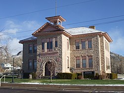
In 1980, 10-year-old Jason Hardman petitioned Elsinore's mayor for permission to open a library. The library was initially set up in the basement of the town's public school (the historic town hall building), with 1,000 books. Hardman became the librarian, making him the youngest librarian in the United States. By 1982, the library had 10,000 volumes, largely from donations. By 1985, it had 17,000 volumes. [10]

Staples Art Center

The town also has a small art gallery and gift shop to support area artists. One of the founding members, Sue Ann Staples Brady, named it for her great-great-grandfather, George Staples, whose work with Native American tribes was instrumental in its founding.

Related Research Articles

<span class="mw-page-title-main">Sevier County, Utah</span> County in Utah, United States

Sevier County is a county in Utah, United States. As of the 2020 United States Census, the population was 21,522. Its county seat and largest city is Richfield.

<span class="mw-page-title-main">Hamilton City, California</span> Census-designated place in California, United States

Hamilton City is a census-designated place (CDP) in Glenn County, California, United States. The population was 1,759 at the 2010 census, down from 1,903 at the 2000 census. Hamilton City is located 9.5 miles (15 km) east of Orland, and 10 miles west of Chico at an elevation of 151 feet. The community is inside area code 530. The default prefix used for wired telephones in the Hamilton City area is 826. The postal ZIP Code is 95951.

<span class="mw-page-title-main">Spreckels, California</span> Unincorporated community in California, United States

Spreckels is an unincorporated community and census-designated place (CDP) in the Salinas Valley of Monterey County, California, United States. Spreckels is located 3 miles (5 km) south of Salinas, at an elevation of 62 ft (19 m). Its population was 692 at the 2020 census.

<span class="mw-page-title-main">Sugar City, Idaho</span> City in Idaho, United States

Sugar City is a city in Madison County, Idaho, United States. The population was 1,715 at the 2020 census, up from 1,514 in 2010. It is part of the Rexburg Micropolitan Statistical Area.

<span class="mw-page-title-main">Halstad, Minnesota</span> City in Minnesota, United States

Halstad is a city in Norman County, Minnesota. The population was 564 at the time of the 2020 census. The city is known for its production of sugar beets, and has a statue of a sugar beet, known as the world's largest sugar beet, to commemorate this status.

<span class="mw-page-title-main">Garland, Utah</span> City in Utah, United States

Garland is a city in northeastern Box Elder County, Utah, United States. The population was 2,400 at the 2010 census.

<span class="mw-page-title-main">Amalga, Utah</span> Town in the state of Utah, United States

Amalga is a town in Cache County, Utah, United States. The population was 488 at the 2010 census. It is included in the Logan, Utah-Idaho (partial) Metropolitan Statistical Area.

<span class="mw-page-title-main">Smithfield, Utah</span> City in Utah, United States

Smithfield is a city in Cache County, Utah, United States. The population was 9,495 at the 2010 United States Census, with an estimated population of 12,025 in 2019. It is included in the Logan, Utah-Idaho Metropolitan Statistical Area, and is the second largest city in the area after Logan, the county seat. Smithfield is home to one public high school and three public elementary schools.

<span class="mw-page-title-main">Hatch, Utah</span> Town in the state of Utah, United States

Hatch is a town in Garfield County, Utah, United States. The population was 133 at the 2010 census. It is 260 miles (420 km) south of Salt Lake City.

<span class="mw-page-title-main">Hinckley, Utah</span> Town in the state of Utah, United States

Hinckley is a town in Millard County, Utah, United States, in the middle of the Sevier Desert. Irrigation water from the Sevier River, passing nearby, has been used to turn Hinckley into a farming oasis. The mountains that are common in Utah are seen only in the distance, and beyond the reach of the river, a severe desert prevails. The population was 696 at the 2010 census.

<span class="mw-page-title-main">Leamington, Utah</span> Town in the state of Utah, United States

Leamington is a town in Millard County, Utah. The population was 217 at the time of the 2000 census.

<span class="mw-page-title-main">Annabella, Utah</span> Town in Utah, United States

Annabella is a town in Sevier County, Utah, United States. The population was 795 at the 2010 census, an increase over the 2000 figure of 603.

<span class="mw-page-title-main">Aurora, Utah</span> City in Utah, United States

Aurora is a city in north-central Sevier County, Utah, United States. The population was 1,016 at the 2010 census.

<span class="mw-page-title-main">Joseph, Utah</span> Town in the state of Utah, United States

Joseph is a town in Sevier County, Utah, United States. The population was 269 at the 2000 census. The town was named for Joseph Angell Young, an apostle of the Church of Jesus Christ of Latter-day Saints. Joseph was settled in 1871.

<span class="mw-page-title-main">Koosharem, Utah</span> Town in the state of Utah, United States

Koosharem is a town in Sevier County, Utah, United States. Koosharem is also known as "Grass Valley". It generally comprises the area known as Burrville, Utah on the north, south through the valley and through the town of Koosharem and down to the south end with the town of Greenwich, Utah. The valley is made up of private lands nestled within the Fishlake National Forest. Koosharem is situated at the cross-roads for travelers going between Capitol Reef National Park and Bryce Canyon National Park and/or Zion National Park. Koosharem is also the closest town to the famous Fish Lake. The town also serves as an important point along the many trails of the Piute ATV Trail System.

<span class="mw-page-title-main">Monroe, Utah</span> City in Utah, United States

Monroe is a city in Sevier County, Utah, United States. The population was 2,256 at the 2010 United States Census.

<span class="mw-page-title-main">Redmond, Utah</span> Town in the state of Utah, United States

Redmond is a town in Sevier County, Utah, United States. The population was 730 at the 2010 census. Redmond was first settled in 1876, and named for red mounds to the west of the town.

<span class="mw-page-title-main">Sigurd, Utah</span> Town in the state of Utah, United States

Sigurd is a town in Sevier County, Utah, United States. The population was 429 at the 2010 census.

<span class="mw-page-title-main">North Ogden, Utah</span> City in Utah, United States

North Ogden is a city in Weber County, Utah, United States. The population was 20,916 at the 2020 census. North Ogden is on SR-235, three miles north of Ogden. It is a suburb of that city and is part of the Ogden-Clearfield, Utah Metropolitan Statistical Area.

<span class="mw-page-title-main">Waverly, Washington</span> Town in Washington, United States

Waverly is a town in Spokane County, Washington, United States. The population was 106 at the 2010 census.

References

  1. "US Gazetteer files: 2010, 2000, and 1990". United States Census Bureau. 2011-02-12. Retrieved 2011-04-23.
  2. "2019 U.S. Gazetteer Files". United States Census Bureau. Retrieved August 7, 2020.
  3. 1 2 "Population and Housing Unit Estimates". United States Census Bureau. May 24, 2020. Retrieved May 27, 2020.
  4. 1 2 "U.S. Census website". United States Census Bureau . Retrieved 2008-01-31.
  5. "US Board on Geographic Names". United States Geological Survey. 2007-10-25. Retrieved 2008-01-31.
  6. 1 2 Arrington, Leonard J. (1966). Beet sugar in the West; a history of the Utah-Idaho Sugar Company, 1891-1966. University of Washington Press. pp. 73–75. OCLC   234150.
  7. Van Atta, Dale (Jan 22, 1977). "You name it - there's a town for it". The Deseret News. p. 15. Retrieved 18 October 2015.
  8. dePolo, Craig M. (April 1994). "The Maximum Background Earthquake for the Basin and Range Province, Western North America" (PDF). Bulletin of the Seismological Society of America. 84 (2): 466–472. Retrieved 10 June 2018.
  9. "Census of Population and Housing". Census.gov. Retrieved June 4, 2015.
  10. Noyce, David (July 31, 2005). "Sevier County's down-home residents give it a unique character". Salt Lake Tribune . Retrieved April 29, 2014.

Commons-logo.svg Media related to Elsinore, Utah at Wikimedia Commons