Glenwood, Utah

Last updated

Glenwood, Utah
Glenwood, Sevier County, UT.jpg
Sevier County Utah incorporated and unincorporated areas Glenwood highlighted.svg
Location in Sevier County and the state of Utah.
Coordinates: 38°45′44″N111°59′22″W / 38.76222°N 111.98944°W / 38.76222; -111.98944
Country United States
State Utah
County Sevier
Founded1863
Named for Robert Wilson Glenn
Area
[1]
  Total0.52 sq mi (1.35 km2)
  Land0.52 sq mi (1.35 km2)
  Water0.00 sq mi (0.00 km2)
Elevation
5,272 ft (1,607 m)
Population
 (2010)
  Total464
  Estimate 
(2019) [2]
476
  Density913.63/sq mi (352.84/km2)
Time zone UTC-7 (Mountain (MST))
  Summer (DST) UTC-6 (MDT)
ZIP code
84730
Area code 435
FIPS code 49-29580 [3]
GNIS feature ID1441332 [4]

Glenwood is a town in Sevier County, Utah, United States. The population was 464 at the 2010 census.

Contents

History

Glenwood was established in 1863 by Mormon pioneers. It was named for an early pioneer, Robert Wilson Glenn. The settlement's original name was Glencoe or Glen Cove but was changed in November 1864 when Orson Hyde (an LDS Church leader) visited the settlement and recommended Glenwood. A stone fort was constructed in April 1866.

Glenwood Coop Store Glenwood Utah Coop.jpeg
Glenwood Coop Store

The Black Hawk War of 1867 between the settlers and the local Indians left Glenwood deserted for one year, but it was later resettled in 1868 after peace resumed.

Glenwood was an excellent site for a settlement, owing to fresh springs that naturally bubbled from the hills east of town. The springs still feed Glenwood's culinary water supply and supply water for the State of Utah fish hatchery southeast of town. A gristmill was built in Glenwood that became the first of its kind in the county.

A ZCMI co-operative building was built at the intersection of Main and Center streets in 1878. For several years it was the largest building in the county. As families moved out of Glenwood, Isaac Washington Pierce Jr., a resident of Glenwood, bought out all shares in the store and ran the store as a privately owned business for many years.( [5] ). It still stands as the main historical landmark in town, although it is currently abandoned.
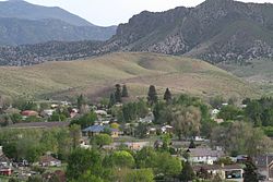
Geography

Field west of Glenwood, Sevier County, UT, showing irrigation.jpg

According to the United States Census Bureau, the town has a total area of 0.5 square mile (1.4 km2), all land. The ZIP Code for the town is 84730.

The Mill Canyon-Sage Flat Watershed Project located in the drainage above Glenwood is designed to reduce flood damage in the area. Completed in 1959, this was the first project in the United States under the Watershed Protection and Flood Prevention Act. A major flood occurred during the final stages of completion, and residents claimed the project paid for itself by controlling this one flood. [6]

Climate

Large seasonal temperature differences typify this climatic region, with warm to hot (and often humid) summers and cold (sometimes severely cold) winters. According to the Köppen Climate Classification system, Glenwood has a humid continental climate, abbreviated "Dfb" on climate maps. [7]

Demographics

Historical population
CensusPop.Note
1880 462
1890 4967.4%
1900 422−14.9%
1910 359−14.9%
1920 56457.1%
1930 350−37.9%
1940 38510.0%
1950 338−12.2%
1960 277−18.0%
1970 212−23.5%
1980 447110.8%
1990 437−2.2%
2000 4370.0%
2010 4646.2%
2019 (est.)476 [2] 2.6%
Source: U.S. Census Bureau [8]

As of the census [3] of 2000, there were 437 people, 140 households, and 120 families residing in the town. The population density was 813.1 people per square mile (312.5/km2). There were 152 housing units at an average density of 282.8 per square mile (108.7/km2). The racial makeup of the town was 98.40% White, 0.23% Native American, 0.69% Asian, 0.23% from other races, and 0.46% from two or more races. Hispanic or Latino of any race were 0.69% of the population.

There were 140 households, out of which 38.6% had children under 18 living with them, 82.9% were married couples living together, 3.6% had a female householder with no husband present, and 13.6% were non-families. 13.6% of all households were made up of individuals, and 8.6% had someone living alone who was 65 years or older. The average household size was 3.12, and the average family size was 3.44.

In the town, the population was spread out, with 30.9% under 18, 10.8% from 18 to 24, 18.8% from 25 to 44, 26.3% from 45 to 64, and 13.3% who were 65 years of age or older. The median age was 36 years. For every 100 females, there were 106.1 males. For every 100 females aged 18 and over, there were 105.4 males.

The median income for a household in the town was $45,192, and the median income for a family was $47,396. Males had a median income of $31,875 versus $19,286 for females. The per capita income for the town was $14,571. About 2.3% of families and 6.0% of the population were below the poverty line, including 4.2% of those under age 18 and 5.6% of those aged 65 or over.

Historically the town population has cycled, with a high of 564 in the 1920 Census, and a low of 212 in the 1970 Census. [9]

Notable people

See also

Notes

  1. "2019 U.S. Gazetteer Files". United States Census Bureau. Retrieved August 7, 2020.
  2. 1 2 "Population and Housing Unit Estimates". United States Census Bureau. May 24, 2020. Retrieved May 27, 2020.
  3. 1 2 "U.S. Census website". United States Census Bureau . Retrieved January 31, 2008.
  4. "US Board on Geographic Names". United States Geological Survey. October 25, 2007. Retrieved January 31, 2008.
  5. Issac Washington Pierce Jr Families Histories, p19, compiled by Ruby Taylor Gourley
  6. http://www.water.utah.gov/planning/swp/sevier/swp_sr09.pdf found on page 9-2
  7. "Glenwood, Utah Köppen Climate Classification (Weatherbase)". Weatherbase.
  8. "Census of Population and Housing". U.S. Census Bureau. Retrieved November 18, 2011.
  9. "Population by Community and Census Precincts: From 1890 to 2000" (PDF). Historic Population Tables-Decennial Census. Utah Governor's Office of Planning & Budget. p. 2.
  10. "Archived copy". Archived from the original on September 4, 2006. Retrieved July 22, 2006.{{cite web}}: CS1 maint: archived copy as title (link)
  11. "2004 annual rep 20050511.indd" (PDF). Archived from the original (PDF) on December 8, 2005. Retrieved July 22, 2006.
  12. "Gadfly Online". www.gadflyonline.com.
  13. The Fathers of Capitol Reef National Park Archived April 19, 2015, at the Wayback Machine

Further reading

Related Research Articles

<span class="mw-page-title-main">Sanpete County, Utah</span> County in Utah, United States

Sanpete County is a county in the U.S. state of Utah. As of the 2020 United States Census, the population was 28,437. Its county seat is Manti, and its largest city is Ephraim. The county was created in 1850.

<span class="mw-page-title-main">Sevier County, Utah</span> County in Utah, United States

Sevier County is a county in Utah, United States. As of the 2020 United States Census, the population was 21,522. Its county seat and largest city is Richfield.

<span class="mw-page-title-main">Paris, Idaho</span> City in Idaho, United States

Paris is a city and county seat of Bear Lake County, Idaho, United States. Located on the western side of the Bear Lake Valley, the city's population was 513 at the 2010 census, down from 576 in 2000. Paris was settled on September 26, 1863, by pioneer settlers of the Church of Jesus Christ of Latter-day Saints.

<span class="mw-page-title-main">Snowville, Utah</span> Town in the state of Utah, United States

Snowville is a town in Box Elder County, Utah, United States. The population was 167 at the 2010 census.

<span class="mw-page-title-main">Hatch, Utah</span> Town in the state of Utah, United States

Hatch is a town in Garfield County, Utah, United States. The population was 133 at the 2010 census. It is 260 miles (420 km) south of Salt Lake City.

<span class="mw-page-title-main">Enoch, Utah</span> City in Utah, United States

Enoch is a city in Iron County, Utah, United States, and is located approximately 7 miles (11 km) northeast of Cedar City in the northeast part of Cedar Valley. The population was 5,803 at the 2010 census, up from 3,467 at the 2000 census. As of 2018 the estimated population was 7,039.

<span class="mw-page-title-main">Nephi, Utah</span> City in and county seat of Juan County, Utah, United States

Nephi is a city in Juab County, Utah, United States. It is part of the Provo–Orem metropolitan area. The population was 6,443 at the 2020 census. It is the county seat of Juab County. It was settled by Mormon pioneers in 1851 as Salt Creek, and it acquired its current name in 1882. It is the principal city in the Juab Valley, an agricultural area. Nephi was named after Nephi, son of Lehi, from the Book of Mormon.

<span class="mw-page-title-main">Hinckley, Utah</span> Town in the state of Utah, United States

Hinckley is a town in Millard County, Utah, United States, in the middle of the Sevier Desert. Irrigation water from the Sevier River, passing nearby, has been used to turn Hinckley into a farming oasis. The mountains that are common in Utah are seen only in the distance, and beyond the reach of the river, a severe desert prevails. The population was 614 at the 2020 census.

<span class="mw-page-title-main">Kanosh, Utah</span> Town in the state of Utah, United States

Kanosh is a town in Millard County, Utah, United States. The population was 474 at the 2010 census.

<span class="mw-page-title-main">Meadow, Utah</span> Town in the state of Utah, United States

Meadow is a town in Millard County, Utah, United States. The population was 254 at the 2000 census. Originally called Meadow Creek, the town is located about eight miles south of Fillmore.

<span class="mw-page-title-main">Bluff, Utah</span> Incorporated town and municipality in Utah, United States

Bluff is a town in San Juan County, Utah, United States. The population was 320 at the 2000 census. Bluff incorporated in 2018. Ann Leppanen is currently the mayor.

<span class="mw-page-title-main">Manti, Utah</span> City in Utah, United States

Manti is a city in and the county seat of Sanpete County, Utah, United States. The population was 3,276 at the 2010 United States Census.

<span class="mw-page-title-main">Annabella, Utah</span> Town in Utah, United States

Annabella is a town in Sevier County, Utah, United States. The population was 795 at the 2010 census, an increase over the 2000 figure of 603.

<span class="mw-page-title-main">Aurora, Utah</span> City in Utah, United States

Aurora is a city in north-central Sevier County, Utah, United States. The population was 923 in the 2020 Census.

<span class="mw-page-title-main">Monroe, Utah</span> City in Utah, United States

Monroe is a city in Sevier County, Utah, United States. The population was 2,256 at the 2010 United States Census.

<span class="mw-page-title-main">Redmond, Utah</span> Town in the state of Utah, United States

Redmond is a town in Sevier County, Utah, United States. The population was 730 at the 2010 census. Redmond was first settled in 1876, and named for red mounds to the west of the town.

<span class="mw-page-title-main">Richfield, Utah</span> City in the United States

Richfield is a city in and the county seat of Sevier County, Utah, United States, and is the largest city in southern-central Utah.

<span class="mw-page-title-main">Oakley, Utah</span> City in Utah, United States

Oakley is a city in Summit County, Utah, United States. It is part of the Salt Lake City, Utah Metropolitan Statistical Area. The population was 1,470 at the 2010 census.

<span class="mw-page-title-main">Goshen, Utah</span> Town in the state of Utah, United States

Goshen is a town in Utah County, Utah, United States. It is part of the Provo–Orem Metropolitan Statistical Area. The population was 921 at the 2010 census.

<span class="mw-page-title-main">Loa, Utah</span> Town in the state of Utah, United States

Loa is a town in, and the county seat of, Wayne County, Utah, United States, along State Route 24. The population was 572 at the 2010 census.