National Register of Historic Places listings in Sevier County, Utah

Last updated

Location of Sevier County in Utah Map of Utah highlighting Sevier County.svg
Location of Sevier County in Utah

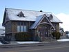
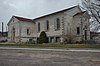
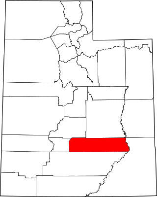
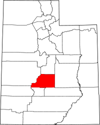
This is a list of the National Register of Historic Places listings in Sevier County, Utah.

Contents

This is intended to be a complete list of the properties and districts on the National Register of Historic Places in Sevier County, Utah, United States. Latitude and longitude coordinates are provided for many National Register properties and districts; these locations may be seen together in a map. [1]

Sevier County and Sanpete County make up the "Little Scandinavia" portion of Utah, where many of Utah's 20,000 Scandinavian immigrants during the 19th century settled. Pair-houses, a Scandinavian home form, are relatively more common here than elsewhere in Utah.

There are 24 properties and districts listed on the National Register in the county. Another 5 sites in the county were once listed, but have since been removed.


    This National Park Service list is complete through NPS recent listings posted August 25, 2023. [2]

Current listings

[3] Name on the Register [4] ImageDate listed [5] Location City or townDescription
1 Aspen-Cloud Rock Shelters November 1, 1979
(#79002510)
Address Restricted, [6] in Saleratus Canyon on Old Woman Plateau
Salina Archaic rock shelters that include archaeological remains of the earliest houses found in Utah.
2 Elsinore Sugar Factory
Elsinore Sugar Factory Elsinore Utah Sugar Factory.jpeg
Elsinore Sugar Factory
June 17, 1980
(#80003959)
East of Elsinore
38°40′53″N112°07′24″W / 38.681389°N 112.123333°W / 38.681389; -112.123333 (Elsinore Sugar Factory)
Elsinore
3 Elsinore White Rock Schoolhouse
Elsinore White Rock Schoolhouse White Rock Schoolhouse Elsinore Utah.jpeg
Elsinore White Rock Schoolhouse
January 18, 1978
(#78002692)
15 E. 200 North
38°41′10″N112°08′50″W / 38.686111°N 112.147222°W / 38.686111; -112.147222 (Elsinore White Rock Schoolhouse)
Elsinore
4 Fish Lake Cut-off of the Old Spanish Trail Archeological District, Red Creek–Sheep Valley Segment January 14, 2013
(#12001184)
Address Restricted, [6] in Fishlake National Forest
Salina vicinityDesignated by archaeological site code 42SV2828, the cut-off was part of an important interstate trade route about 1832–1853.
5 Glenwood Cooperative Store
Glenwood Cooperative Store Glenwood Utah Coop.jpeg
Glenwood Cooperative Store
April 29, 1980
(#80003960)
15 W. Center St.
38°45′47″N111°59′23″W / 38.763056°N 111.989722°W / 38.763056; -111.989722 (Glenwood Cooperative Store)
Glenwood
6 Gooseberry Valley Archeological District September 4, 1980
(#80003968)
Address Restricted, [6] southeast of Salina in Fishlake National Forest
Salina Collection of archaeological sites left by the Fremont culture
7 Jens Larson Jenson Lime Kiln
Jens Larson Jenson Lime Kiln Jenson Lime Kiln Richfield Utah.jpeg
Jens Larson Jenson Lime Kiln
December 22, 1978
(#78002693)
2 miles (3.2 km) north of Richfield
38°47′36″N112°05′08″W / 38.793333°N 112.085556°W / 38.793333; -112.085556 (Jens Larson Jenson Lime Kiln)
Richfield
8 Martin Johnson House
Martin Johnson House Johnson House Glenwood Utah.jpeg
Martin Johnson House
October 20, 1982
(#82001757)
45 W. 400 South
38°45′27″N111°59′25″W / 38.7575°N 111.990278°W / 38.7575; -111.990278 (Martin Johnson House)
Glenwood
9 Monroe City Hall
Monroe City Hall Monroe City Library.jpg
Monroe City Hall
April 1, 1985
(#85000814)
55 N. Main St.
38°37′58″N112°07′18″W / 38.632764°N 112.121789°W / 38.632764; -112.121789 (Monroe City Hall)
Monroe Spanish Colonial Revival building built in 1934, now the Monroe Public Library building.
10 Monroe Presbyterian Church
Monroe Presbyterian Church Monroe Utah Presbyterian Church.jpeg
Monroe Presbyterian Church
March 27, 1980
(#80003963)
20 W. 100 North
38°38′02″N112°07′16″W / 38.633889°N 112.121111°W / 38.633889; -112.121111 (Monroe Presbyterian Church)
Monroe
11 Old Spanish Trail Archeological District, Ivie Creek–Emigrant Pass Segment January 14, 2013
(#12001185)
Address Restricted, [6] in Fishlake National Forest
Salina vicinity
12 Joseph William Parker Farm
Joseph William Parker Farm Parker Farm Joseph Utah.jpeg
Joseph William Parker Farm
March 25, 1977
(#77001318)
2.5 miles (4.0 km) northeast of Joseph
38°39′18″N112°11′39″W / 38.655°N 112.194167°W / 38.655; -112.194167 (Joseph William Parker Farm)
Joseph
13 Peterson-Burr House
Peterson-Burr House Peterson-Burr House Salina Utah.jpeg
Peterson-Burr House
February 18, 1994
(#94000037)
190 W. Main
38°57′28″N111°51′43″W / 38.957778°N 111.861944°W / 38.957778; -111.861944 (Peterson-Burr House)
Salina
14 Redmond Hotel
Redmond Hotel Redmond Hotel Redmond Utah.jpeg
Redmond Hotel
June 20, 1980
(#80003964)
15 E. Main St.
39°00′22″N111°51′48″W / 39.006111°N 111.863333°W / 39.006111; -111.863333 (Redmond Hotel)
Redmond
15 Redmond Town Hall
Redmond Town Hall Redmond Utah town hall.jpeg
Redmond Town Hall
September 13, 1976
(#76001836)
18 W. Main St.
39°00′22″N111°51′50″W / 39.006111°N 111.863889°W / 39.006111; -111.863889 (Redmond Town Hall)
Redmond
16 Richfield Carnegie Library
Richfield Carnegie Library Carnegie Library Richfield Utah.jpeg
Richfield Carnegie Library
October 25, 1984
(#84000153)
83 E. Center St.
38°46′06″N112°04′57″W / 38.768333°N 112.0825°W / 38.768333; -112.0825 (Richfield Carnegie Library)
Richfield
17 Salina Municipal Building and Library
Salina Municipal Building and Library Salina Utah.jpg
Salina Municipal Building and Library
April 9, 1986
(#86000742)
90 W. Main
38°57′28″N111°51′38″W / 38.957778°N 111.860556°W / 38.957778; -111.860556 (Salina Municipal Building and Library)
Salina
18 Salina Presbyterian Church
Salina Presbyterian Church Salina Utah Presbyterian Church.jpeg
Salina Presbyterian Church
March 27, 1980
(#80003967)
204 S. 1st East
38°57′17″N111°51′27″W / 38.954722°N 111.8575°W / 38.954722; -111.8575 (Salina Presbyterian Church)
Salina
19 Sevier Ward Church
Sevier Ward Church Sevier Ward Church Sevier Utah.jpeg
Sevier Ward Church
June 24, 1980
(#80003969)
East of Sevier along U.S. Route 89
38°35′43″N112°14′58″W / 38.595278°N 112.249444°W / 38.595278; -112.249444 (Sevier Ward Church)
Sevier
20 Soren Simonsen House
Soren Simonsen House Simonsen House Monroe Utah.jpeg
Soren Simonsen House
October 20, 1982
(#82001758)
55 W. 200 North
38°38′06″N112°07′19″W / 38.635°N 112.121944°W / 38.635; -112.121944 (Soren Simonsen House)
Monroe
21 Sudden Shelter (42SV6) January 4, 1989
(#88003009)
Address Restricted [6]
Salina A cave that has yielded projectile points from a range of archaeological periods
22 US Post Office-Richfield Main
US Post Office-Richfield Main Richfield Utah post office.jpeg
US Post Office-Richfield Main
November 27, 1989
(#89001999)
93 N. Main
38°46′09″N112°05′04″W / 38.769167°N 112.084444°W / 38.769167; -112.084444 (US Post Office-Richfield Main)
Richfield
23 Joseph Wall Gristmill
Joseph Wall Gristmill Wall Mill Glenwood Utah.jpeg
Joseph Wall Gristmill
June 20, 1980
(#80003961)
355 S. 250 East
38°45′30″N111°59′05″W / 38.758333°N 111.984722°W / 38.758333; -111.984722 (Joseph Wall Gristmill)
Glenwood
24 Young Block
Young Block Young Block Richfield Utah.jpeg
Young Block
June 24, 1980
(#80003965)
3-17 S. Main St.
38°46′04″N112°05′01″W / 38.767778°N 112.083611°W / 38.767778; -112.083611 (Young Block)
Richfield

Former listings

[3] Name on the RegisterImageDate listedDate removedLocationCity or townDescription
1 Monroe Methodist Episcopal Church May 23, 1980
(#80003962)
September 3, 200955 W 100 West
Monroe Torn down in 1996. Portions relocated to Thanksgiving Point in Lehi. [7]
2 Ralph Ramsay House July 8, 1975
(#75001824)
September 3, 200957 E. 200 North
38°46′16″N112°04′59″W / 38.7711°N 112.0831°W / 38.7711; -112.0831 (Ralph Ramsay House)
Richfield Demolished in January 2008 [8]
3 Richfield Tithing Office January 25, 1985
(#85000284)
March 8, 1988190 W. Center St.
Richfield
4 Old Sevier County Courthouse May 30, 1975
(#75002136)
November 29, 1976Main St. between 200 and 300 North
Richfield Demolished in November and December, 1975. [9]
5 Salina Hospital
Salina Hospital Salina Hospital Salina Utah.jpeg
Salina Hospital
June 19, 1980
(#80003966)
August 15, 2023330 W. Main St.
38°57′28″N111°51′54″W / 38.957778°N 111.865°W / 38.957778; -111.865 (Salina Hospital)
Salina

See also

Related Research Articles

<span class="mw-page-title-main">National Register of Historic Places listings in Daggett County, Utah</span>

This is a list of the National Register of Historic Places listings in Daggett County, Utah.

<span class="mw-page-title-main">National Register of Historic Places listings in Davis County, Utah</span>

This is a list of the National Register of Historic Places listings in Davis County, Utah.

<span class="mw-page-title-main">National Register of Historic Places listings in Box Elder County, Utah</span>

This is a list of the National Register of Historic Places listings in Box Elder County, Utah.

<span class="mw-page-title-main">National Register of Historic Places listings in Beaver County, Utah</span>

This is a list of the National Register of Historic Places listings in Beaver County, Utah.

<span class="mw-page-title-main">National Register of Historic Places listings in Emery County, Utah</span>

This is a list of the National Register of Historic Places listings in Emery County, Utah.

<span class="mw-page-title-main">National Register of Historic Places listings in Grand County, Utah</span>

This is a list of the National Register of Historic Places listings in Grand County, Utah.

<span class="mw-page-title-main">National Register of Historic Places listings in Garfield County, Utah</span>

This is a list of the National Register of Historic Places listings in Garfield County, Utah.

<span class="mw-page-title-main">National Register of Historic Places listings in Iron County, Utah</span>

This is a list of the National Register of Historic Places listings in Iron County, Utah.

<span class="mw-page-title-main">National Register of Historic Places listings in Juab County, Utah</span>

This is a list of the National Register of Historic Places listings in Juab County, Utah.

<span class="mw-page-title-main">National Register of Historic Places listings in Kane County, Utah</span>

This is a list of the National Register of Historic Places listings in Kane County, Utah.

<span class="mw-page-title-main">National Register of Historic Places listings in Millard County, Utah</span>

This is a list of the National Register of Historic Places listings in Millard County, Utah.

<span class="mw-page-title-main">National Register of Historic Places listings in Tooele County, Utah</span>

This is a list of the National Register of Historic Places listings in Tooele County, Utah.

<span class="mw-page-title-main">National Register of Historic Places listings in San Juan County, Utah</span>

This is a list of the National Register of Historic Places listings in San Juan County, Utah.

<span class="mw-page-title-main">National Register of Historic Places listings in Sanpete County, Utah</span>

This is a list of the National Register of Historic Places listings in Sanpete County, Utah.

<span class="mw-page-title-main">National Register of Historic Places listings in Wayne County, Utah</span>

This is a list of the National Register of Historic Places listings in Wayne County, Utah.

<span class="mw-page-title-main">National Register of Historic Places listings in Uintah County, Utah</span>

This is a list of the National Register of Historic Places listings in Uintah County, Utah.

<span class="mw-page-title-main">National Register of Historic Places listings in Utah County, Utah</span>

This is a list of the National Register of Historic Places listings in Utah County, Utah.

This is a list of the National Register of Historic Places listings in Sevier County, Tennessee.

<span class="mw-page-title-main">National Register of Historic Places listings in Sevier County, Arkansas</span>

This is a list of the National Register of Historic Places listings in Sevier County, Arkansas.

This is a list of the National Register of Historic Places listings in Zion National Park.

References

  1. The latitude and longitude information provided in this table was derived originally from the National Register Information System, which has been found to be fairly accurate for about 99% of listings. Some locations in this table may have been corrected to current GPS standards.
  2. National Park Service, United States Department of the Interior, "National Register of Historic Places: Weekly List Actions", retrieved August 25, 2023.
  3. 1 2 Numbers represent an alphabetical ordering by significant words. Various colorings, defined here, differentiate National Historic Landmarks and historic districts from other NRHP buildings, structures, sites or objects.
  4. "National Register Information System". National Register of Historic Places . National Park Service. April 24, 2008.
  5. The eight-digit number below each date is the number assigned to each location in the National Register Information System database, which can be viewed by clicking the number.
  6. 1 2 3 4 5 Some listings on the NRHP are highly sensitive sites and may be subject to looting or vandalism. The NRHP lists this site as "Address Restricted."
  7. "Monroe Methodist Landmark Gets New Home In Park". The Richfield Reaper . July 10, 1996. p. Extra, page 2. Retrieved August 31, 2022 via Newspapers.com.
  8. "Demolition of the Ralph Ramsay House in Richfield, Utah".
  9. "Courthouse Razing Ends Battle". The Richfield Reaper . December 4, 1975. p. 1. Retrieved August 31, 2022 via Newspapers.com.
Map all coordinates using: OpenStreetMap

Commons-logo.svg Media related to National Register of Historic Places in Sevier County, Utah at Wikimedia Commons