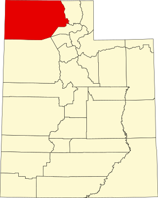
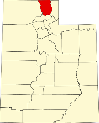
[3] Name on the Register [4] Image Date listed [5] Location City or town Description 1 Joseph Adams House Joseph Adams House February 17, 1978 (# 78002655 300 N. Adamswood Rd. 41°03′55″N 111°56′42″W / 41.065278°N 111.945°W / 41.065278; -111.945 (Joseph Adams House ) Layton 2 James and Hannah Atkinson House James and Hannah Atkinson House July 15, 1999 (# 99000847 1510 S. 1100 West 40°52′29″N 111°54′40″W / 40.874722°N 111.911111°W / 40.874722; -111.911111 (James and Hannah Atkinson House ) Woods Cross 3 Barnard-Garn-Barber House Barnard-Garn-Barber House November 17, 1997 (# 97001309 1198 N. Main St. 40°55′54″N 111°52′43″W / 40.931667°N 111.878611°W / 40.931667; -111.878611 (Barnard-Garn-Barber House ) Centerville 4 John George Moroni Barnes House John George Moroni Barnes House February 11, 1982 (# 82004120 42 W. Center St. 41°02′07″N 111°56′20″W / 41.035278°N 111.938889°W / 41.035278; -111.938889 (John George Moroni Barnes House ) Kaysville 5 John R. Barnes House John R. Barnes House July 23, 1982 (# 82004121 10 S. 100 West 41°02′05″N 111°56′23″W / 41.034722°N 111.939722°W / 41.034722; -111.939722 (John R. Barnes House ) Kaysville 6 Henry Blood House Henry Blood House April 29, 1980 (# 80003897 95 S. 300 West 41°02′01″N 111°56′35″W / 41.033611°N 111.943056°W / 41.033611; -111.943056 (Henry Blood House ) Kaysville Home of Henry H. Blood , former Governor of Utah. 7 Bountiful Historic District Bountiful Historic District October 26, 2005 (# 05001194 Roughly bounded by 200 W., 500 S., 400 E., and 400 N. 40°53′21″N 111°52′42″W / 40.889167°N 111.878333°W / 40.889167; -111.878333 (Bountiful Historic District ) Bountiful 8 Bountiful Tabernacle Bountiful Tabernacle January 1, 1976 (# 76001813 Main and Center Sts. 40°53′21″N 111°52′43″W / 40.889167°N 111.878611°W / 40.889167; -111.878611 (Bountiful Tabernacle ) Bountiful 9 Thomas and Margaret Brandon House Thomas and Margaret Brandon House November 17, 1997 (# 97001310 185 E. Center St. 40°55′06″N 111°52′34″W / 40.918333°N 111.876111°W / 40.918333; -111.876111 (Thomas and Margaret Brandon House ) Centerville 10 William Capener House William Capener House January 5, 1984 (# 84002172 252 N. 400 East 40°55′12″N 111°52′16″W / 40.92°N 111.871111°W / 40.92; -111.871111 (William Capener House ) Centerville 11 Leroy and Alice Cheney House Leroy and Alice Cheney House July 12, 2021 (# 100006718 676 North Main St. 40°55′30″N 111°52′44″W / 40.9250°N 111.8789°W / 40.9250; -111.8789 (Leroy and Alice Cheney House ) Centerville 12 Clark Lane Historic District Clark Lane Historic District October 7, 1994 (# 94001208 207-399 W. State and 33 N. 200 West 40°58′50″N 111°53′36″W / 40.980556°N 111.893333°W / 40.980556; -111.893333 (Clark Lane Historic District ) Farmington 13 Osmyn and Emily Deuel House Osmyn and Emily Deuel House November 17, 1997 (# 97001311 271 S. 200 East 40°54′53″N 111°52′31″W / 40.914722°N 111.875278°W / 40.914722; -111.875278 (Osmyn and Emily Deuel House ) Centerville 14 John, Harriet, and Eliza Jennett Duncan House John, Harriet, and Eliza Jennett Duncan House November 17, 1997 (# 97001312 445 N. 400 East 40°55′19″N 111°52′21″W / 40.921944°N 111.8725°W / 40.921944; -111.8725 (John, Harriet, and Eliza Jennett Duncan House ) Centerville 15 James and Jane Eldredge House James and Jane Eldredge House June 10, 2005 (# 05000595 564 W. 400 North 40°53′40″N 111°53′35″W / 40.894444°N 111.893056°W / 40.894444; -111.893056 (James and Jane Eldredge House ) West Bountiful 16 Farmer's Union Building Farmer's Union Building November 30, 1978 (# 78002656 12 S. Main St. 41°03′38″N 111°57′54″W / 41.060556°N 111.965°W / 41.060556; -111.965 (Farmer's Union Building ) Layton 17 Farmington Main Street Historic District Farmington Main Street Historic District October 20, 2011 (# 11000756 Approximately Main St. from 200 South to 600 North, along 600 North to Park Lane and 100 North from Main St to 100 West 40°58′50″N 111°53′15″W / 40.980556°N 111.8875°W / 40.980556; -111.8875 (Farmington Main Street Historic District ) Farmington 18 Farmington Tithing Office Farmington Tithing Office March 28, 1985 (# 85000686 110 N. Main St. 40°58′56″N 111°53′14″W / 40.982361°N 111.887222°W / 40.982361; -111.887222 (Farmington Tithing Office ) Farmington 19 Fielding Garr Ranch Fielding Garr Ranch January 21, 1983 (# 83004402 Off State Route 127 40°55′31″N 112°09′59″W / 40.925278°N 112.166389°W / 40.925278; -112.166389 (Fielding Garr Ranch ) Antelope Island 20 First National Bank of Layton First National Bank of Layton April 5, 2006 (# 06000232 50 W. Gentile St. 41°03′38″N 111°57′57″W / 41.060556°N 111.965833°W / 41.060556; -111.965833 (First National Bank of Layton ) Layton 21 Joseph N. and Algie Ford House Joseph N. and Algie Ford House November 18, 2005 (# 05001289 1394 N. Main St. 40°56′12″N 111°52′39″W / 40.936667°N 111.8775°W / 40.936667; -111.8775 (Joseph N. and Algie Ford House ) Centerville 22 Ford-Rigby House Ford-Rigby House November 17, 1997 (# 97001313 1592 N. Main St. 40°56′27″N 111°52′47″W / 40.940833°N 111.879722°W / 40.940833; -111.879722 (Ford-Rigby House ) Centerville 23 James Green House James Green House February 11, 1982 (# 82004118 206 N. 100 East 40°53′30″N 111°52′38″W / 40.891667°N 111.877222°W / 40.891667; -111.877222 (James Green House ) Bountiful 24 Hector C. Haight House Hector C. Haight House May 17, 1985 (# 85001141 208 N. Main St. 40°59′03″N 111°53′11″W / 40.984167°N 111.886389°W / 40.984167; -111.886389 (Hector C. Haight House ) Farmington 25 Thomas and Caroline Harris House Thomas and Caroline Harris House June 11, 1998 (# 98000639 275 S. 200 East 40°54′54″N 111°52′30″W / 40.915°N 111.875°W / 40.915; -111.875 (Thomas and Caroline Harris House ) Centerville 26 Harris-Tingey House Harris-Tingey House November 17, 1997 (# 97001314 269 E. Center St. 40°55′03″N 111°52′28″W / 40.9175°N 111.874444°W / 40.9175; -111.874444 (Harris-Tingey House ) Centerville 27 Joseph and Ann Hill Cabin Joseph and Ann Hill Cabin December 4, 2015 (# 15000130 2133 W. 1000 South 41°02′44″N 112°00′22″W / 41.045632°N 112.006086°W / 41.045632; -112.006086 (Joseph and Ann Hill Cabin ) Layton 28 Holland-Smith-Brown House Holland-Smith-Brown House November 17, 1997 (# 97001315 19 S. 200 East 40°55′01″N 111°52′31″W / 40.916944°N 111.875278°W / 40.916944; -111.875278 (Holland-Smith-Brown House ) Centerville 29 Kaysville City Hall Kaysville City Hall September 30, 2019 (# 100004476 44 N. Main St. 41°02′07″N 111°56′19″W / 41.0354°N 111.9385°W / 41.0354; -111.9385 (Kaysville City Hall ) Kaysville 30 Kilbourn-Leak House Kilbourn-Leak House November 17, 1997 (# 97001316 170 N. 200 East 40°55′10″N 111°52′31″W / 40.919444°N 111.875278°W / 40.919444; -111.875278 (Kilbourn-Leak House ) Centerville 31 George Quincy Knowlton House George Quincy Knowlton House April 17, 1995 (# 95000416 93 E. 400 North 40°59′14″N 111°53′09″W / 40.987361°N 111.885833°W / 40.987361; -111.885833 (George Quincy Knowlton House ) Farmington 32 Lagoon Carousel Lagoon Carousel October 24, 2012 (# 12000883 375 N. Lagoon Dr. 40°59′05″N 111°53′38″W / 40.984830°N 111.893870°W / 40.984830; -111.893870 (Lagoon Carousel ) Farmington Built in 1913, this hand carved Herschell-Spillman carousel has been at Lagoon Amusement Park since 1918. 33 Lagoon Flying Scooter Lagoon Flying Scooter October 24, 2012 (# 12000884 375 N. Lagoon Dr. 40°59′13″N 111°53′36″W / 40.987070°N 111.893300°W / 40.987070; -111.893300 (Lagoon Flying Scooter ) Farmington A Bisch-Rocco Amusement Company Flying Scooters ride at Lagoon Amusement Park . Installed in 1941, it is currently known as the Flying Aces . 34 Lagoon Roller Coaster Lagoon Roller Coaster October 24, 2012 (# 12000885 375 N. Lagoon Dr. 40°59′05″N 111°53′42″W / 40.984861°N 111.895137°W / 40.984861; -111.895137 (Lagoon Roller Coaster ) Farmington The 7th oldest roller coaster in the world, at Lagoon Amusement Park since 1921 35 Layton Oregon Short Line Railroad Station Layton Oregon Short Line Railroad Station January 18, 2018 (# 100001979 200 S Main St. 41°03′24″N 111°57′52″W / 41.056770°N 111.964582°W / 41.056770; -111.964582 (Layton Oregon Short Line Railroad Station ) Layton Railroad station built alongside the Oregon Short Line Railroad tracks in 1912. Used by the railroad until the 1960s, and later sold then moved 1,200 feet to the south. The building has housed several businesses since it was vacated by the railroad. 36 George W. Layton House George W. Layton House July 23, 1982 (# 82004122 2767 W. Gentile St. 41°03′35″N 112°01′05″W / 41.059768°N 112.017996°W / 41.059768; -112.017996 (George W. Layton House ) Layton Red brick house with elaborate trim, designed by William Allen . Now a wedding venue. 37 John Henry Layton House John Henry Layton House February 11, 1982 (# 82004123 683 W. Gentile St. 41°03′35″N 111°58′44″W / 41.059744°N 111.978831°W / 41.059744; -111.978831 (John Henry Layton House ) Layton Also designed by William Allen , with reversed plan to George W. Layton House 38 Leonard–Taylor House Leonard–Taylor House September 7, 2023 (# 100009316 94 East 500 North 40°59′19″N 111°53′09″W / 40.9886°N 111.8857°W / 40.9886; -111.8857 (Leonard–Taylor House ) Farmington 39 Mills-Hancock House Mills-Hancock House February 21, 2007 (# 07000077 571 S. 400 West 40°55′06″N 111°52′52″W / 40.918333°N 111.881111°W / 40.918333; -111.881111 (Mills-Hancock House ) Centerville 40 Nathan and Rebecca Cherry and Eliza Ford Porter Farmstead Nathan and Rebecca Cherry and Eliza Ford Porter Farmstead November 17, 1997 (# 97001317 370 W. 400 South 40°54′48″N 111°53′05″W / 40.913333°N 111.884722°W / 40.913333; -111.884722 (Nathan and Rebecca Cherry and Eliza Ford Porter Farmstead ) Centerville 41 Nathan T. and Anna Porter House Nathan T. and Anna Porter House January 21, 2004 (# 03001482 224 S. 210 West 40°54′55″N 111°52′55″W / 40.915278°N 111.881944°W / 40.915278; -111.881944 (Nathan T. and Anna Porter House ) Centerville 42 Melvin Harley Randall House Melvin Harley Randall House June 20, 1980 (# 80003896 390 E. Porter Lane 40°54′46″N 111°52′19″W / 40.912778°N 111.871944°W / 40.912778; -111.871944 (Melvin Harley Randall House ) Centerville 43 Rich-Steeper House Rich-Steeper House November 17, 1997 (# 97001318 415 S. Main St. 40°54′46″N 111°52′42″W / 40.912778°N 111.878333°W / 40.912778; -111.878333 (Rich-Steeper House ) Centerville 44 Richards House Richards House December 23, 1977 (# 77001303 386 N. 100 East 40°59′12″N 111°53′02″W / 40.986667°N 111.883889°W / 40.986667; -111.883889 (Richards House ) Farmington 45 Ron's Phillips 66 Service Station Ron's Phillips 66 Service Station March 26, 2018 (# 100002273 278 N Main St. 40°55′12″N 111°52′44″W / 40.920081°N 111.878964°W / 40.920081; -111.878964 (Ron's Phillips 66 Service Station ) Centerville 46 Salt Lake South East and North West Base Monuments (Salt Lake Base Line) Salt Lake South East and North West Base Monuments (Salt Lake Base Line) January 18, 2018 (# 100001980 1002 S. 3200 West & 209 S. 4500 West 41°04′29″N 112°01′34″W / 41.074823°N 112.026024°W / 41.074823; -112.026024 (Salt Lake South East and North West Base Monuments (Salt Lake Base Line) ) Layton and West Point 47 B.H., Louisa Smith and Cecilia Dibble Roberts House B.H., Louisa Smith and Cecilia Dibble Roberts House November 17, 1997 (# 97001319 315 S. 300 East 40°54′51″N 111°52′21″W / 40.914167°N 111.8725°W / 40.914167; -111.8725 (B.H., Louisa Smith and Cecilia Dibble Roberts House ) Centerville Home of B. H. Roberts 48 Thomas J. and Amanda N. Smith House Thomas J. and Amanda N. Smith House February 2, 2006 (# 05001632 472 N. Main St. 41°02′35″N 111°56′48″W / 41.043056°N 111.946667°W / 41.043056; -111.946667 (Thomas J. and Amanda N. Smith House ) Kaysville 49 Smith-Larsen House Smith-Larsen House November 17, 1997 (# 97001320 280 E. Center St. 40°54′59″N 111°52′27″W / 40.916389°N 111.874167°W / 40.916389; -111.874167 (Smith-Larsen House ) Centerville 50 Smoot Dairy Farmhouse Smoot Dairy Farmhouse March 22, 2016 (# 16000123 1697 N. Main St. 40°56′31″N 111°52′49″W / 40.941956°N 111.880220°W / 40.941956; -111.880220 (Smoot Dairy Farmhouse ) Centerville 51 Stayner-Steed House Stayner-Steed House August 2, 1999 (# 99000846 79 S. 100 East 40°58′45″N 111°53′04″W / 40.979167°N 111.884444°W / 40.979167; -111.884444 (Stayner-Steed House ) Farmington 52 LeConte Stewart House LeConte Stewart House June 28, 1996 (# 96000721 172 W. 100 South 41°02′03″N 111°56′28″W / 41.034167°N 111.941111°W / 41.034167; -111.941111 (LeConte Stewart House ) Kaysville 53 William Henry and Mary Streeper House William Henry and Mary Streeper House November 17, 1997 (# 97001321 1020 N. Main St. 40°55′46″N 111°52′50″W / 40.929444°N 111.880556°W / 40.929444; -111.880556 (William Henry and Mary Streeper House ) Centerville 54 John W., Janet (Nettie), and May Rich Taylor House John W., Janet (Nettie), and May Rich Taylor House October 30, 1997 (# 97001325 49 E. 500 North 40°59′19″N 111°53′11″W / 40.988611°N 111.886389°W / 40.988611; -111.886389 (John W., Janet (Nettie), and May Rich Taylor House ) Farmington 55 Thurston-Chase Cabin Thurston-Chase Cabin November 17, 1997 (# 97001322 975 N. Main St. 40°55′43″N 111°52′45″W / 40.928611°N 111.879167°W / 40.928611; -111.879167 (Thurston-Chase Cabin ) Centerville 56 Thomas Tingey House Thomas Tingey House July 28, 1983 (# 83004401 20 N. 300 East 40°55′03″N 111°52′23″W / 40.9175°N 111.873056°W / 40.9175; -111.873056 (Thomas Tingey House ) Centerville 57 VanFleet Hotel VanFleet Hotel December 19, 1991 (# 91001819 88 E. State St. 40°58′48″N 111°53′05″W / 40.98°N 111.884722°W / 40.98; -111.884722 (VanFleet Hotel ) Farmington 58 Franklin and Amelia Walton House Franklin and Amelia Walton House November 17, 1997 (# 97001323 96 W. 280 South 40°54′53″N 111°52′50″W / 40.914722°N 111.880556°W / 40.914722; -111.880556 (Franklin and Amelia Walton House ) Centerville 59 John and Sarah Jane Wayman House John and Sarah Jane Wayman House January 7, 2015 (# 14001136 240 E. 300 South 40°54′53″N 111°52′27″W / 40.9148°N 111.8741°W / 40.9148; -111.8741 (John and Sarah Jane Wayman House ) Centerville 60 West Bountiful Historic District West Bountiful Historic District June 18, 2004 (# 03000158 800 West (Onion St.) from 400 North to roughly 1350 North (both sides) 40°53′51″N 111°54′05″W / 40.8975°N 111.901389°W / 40.8975; -111.901389 (West Bountiful Historic District ) West Bountiful 61 Thomas and Elizabeth Mills Whitaker House Thomas and Elizabeth Mills Whitaker House March 28, 1996 (# 96000316 168 N. Main St. 40°55′08″N 111°52′43″W / 40.918889°N 111.878611°W / 40.918889; -111.878611 (Thomas and Elizabeth Mills Whitaker House ) Centerville 62 James D. Wilcox House James D. Wilcox House November 26, 1985 (# 85003051 93 E. 100 North 40°58′56″N 111°53′05″W / 40.982222°N 111.884722°W / 40.982222; -111.884722 (James D. Wilcox House ) Farmington