Davis County, Utah

Last updated

Davis County
Davis County Utah photo D Ramey Logan.jpg
Davis County, Utah
Map of Utah highlighting Davis County.svg
Location within the U.S. state of Utah
Utah in United States.svg
Utah's location within the U.S.
Coordinates: 41°01′N112°07′W / 41.01°N 112.12°W / 41.01; -112.12
CountryFlag of the United States.svg United States
StateFlag of Utah.svg  Utah
FoundedOctober 5, 1850
Named for Daniel C. Davis
Seat Farmington
Largest city Layton
Area
  Total634 sq mi (1,640 km2)
  Land299 sq mi (770 km2)
  Water335 sq mi (870 km2)  53%
Population
 (2020)
  Total362,679
  Density570/sq mi (220/km2)
Time zone UTC−7 (Mountain)
  Summer (DST) UTC−6 (MDT)
Congressional districts 1st, 2nd
Website www.daviscountyutah.gov

Davis County is a county in northern Utah, United States. As of the 2020 United States Census, the population was 362,679, [1] making it Utah's third-most populous county. Its county seat is Farmington, [2] and its largest city by both population and area is Layton.

Contents

Davis County is part of the Ogden-Clearfield, UT Metropolitan Statistical Area as well as the Salt Lake City-Provo-Orem, UT Combined Statistical Area.

History

The legislature of the provisional State of Deseret defined the county in an October 5, 1850 act, which also designated Farmington as the seat due to its location midway between boundaries at the Weber River on the north and the Jordan River on the south. It was named for Daniel C. Davis, [3] a captain in the Mormon Battalion. The county boundaries were altered in 1852, 1854, 1855, and in 1862. In 1880 the county gained part of the islands and waters of Great Salt Lake that had previously been attached to Salt Lake County. The county boundary has remained unchanged since that time. [4]

During its first 50 years, Davis County grew slowly. With the advent of the Utah Central Rail Road in 1870, a transition to mechanized agriculture and a surge of commerce, banking, improved roads, new water systems, and electrification of homes began. However, by 1940, the population was barely 16,000.

With the establishment of Hill Air Force Base in northern Davis County and southern Weber County, [5] there was a surge in civilian employment after World War II. The county doubled in population between 1940 and 1950 and doubled again between 1950 and 1960 as part of the nationwide suburb boom that was occurring at the time. By 1990 there were 188,000 residents, and in 2000, there were 239,000. As of 2020, the county population is above 360,000.

Geography

Davis County has an area of 634 square miles (1,640 km2), of which 299 square miles (770 km2) is land and 335 square miles (870 km2) (53%) is water. [6] It is Utah's smallest county by land area and second smallest by total area.

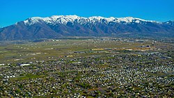
The county lies generally between the Great Salt Lake on the west and the Wasatch Range on the east, which rises to a height of 9,707 feet (2,959 m) in the county at Thurston Peak. [7]

The Great Salt Lake is surrounded by marshland and mudflats, and lies at an average elevation of approximately 4,200 feet (1,300 m), varying depending on the water level, which can lead to drastic changes in the lake size due to its shallowness. Davis County includes Antelope Island, the lake's largest island. The entire island is a state park, designated to protect natural scenery and especially wildlife on the island, which includes bighorn sheep, pronghorn, and a bison herd.

The inhabited portion of Davis County between the lake and the mountain range is called the Wasatch Front, a narrow stretch of land that restricts north–south transportation in the county.

Adjacent counties

Protected areas

  • Antelope Island State Park
  • Crystal West Unit Farmington Bay (part)
  • Farmington Bay Waterfowl Management Area
  • Howard Slough Waterfowl Management Area
  • Wasatch-Cache National Forest (part)

[8]

Lakes

  • Adams Reservoir
  • Farmington Bay
  • Hobbs Reservoir
  • Holmes Reservoir

[8]

Climate

Eastern parts of Davis County experience a humid continental climate (Dsa), while western parts may experience a mediterranean climate (Csa). Summers are dry and hot and winters are cold and wet, but rarely frigid. Snow is frequent during winter, with up to 90 in (230 cm) annually on high bench areas in the east and at least 60 inches (150 cm) on the valley floor. Annual precipitation averages between 18 and 25 inches (460 and 640 mm) in the county, with spring being the wettest season and summer the driest. Summers are hot, with several days each year averaging above 95 °F (35 °C). However, the humidity is low, making for comparatively comfortable temperatures. In winter, temperatures sometimes drop below 0 °F (−18 °C), but rarely for extended periods of time. Compared to Salt Lake County to the south, the weather in Davis County is extreme. Lake-effect snows hit the southern portion of the county harder, and even in non-lake-effect storms, the lack of a rain shadow in Davis County (much of Salt Lake County lies in the rain shadow of the Oquirrh Mountains) means that storms often hit Davis County harder. In addition, canyon winds from the east can sometimes cause devastating wind damage, and wind gusts above 100 mph (160 km/h) have been reported. This occurs when a powerful high pressure system is over Wyoming, and is a frequent occurrence. Extreme wind events, however, seem to have declined in frequency in recent years. [9]

Demographics

Historical population
CensusPop.Note
1850 1,134
1860 2,904156.1%
1870 4,45953.5%
1880 5,27918.4%
1890 6,75127.9%
1900 7,99618.4%
1910 10,19127.5%
1920 11,45012.4%
1930 14,02122.5%
1940 15,78412.6%
1950 30,86795.6%
1960 64,760109.8%
1970 99,02852.9%
1980 146,54048.0%
1990 187,94128.3%
2000 238,99427.2%
2010 306,47928.2%
2020 362,67918.3%
US Decennial Census [10]
1790–1960 [11] 1900–1990 [12]
1990–2000 [13] 2010 [14] 2020 [15]

As of the 2010 United States Census, there were 306,479 people, 93,545 households, and 76,205 families in the county. The population density was 1,025 people per square mile (396 people/km2). There were 97,570 housing units at an average density of 320.95 units per square mile (123.92 units/km2). The racial makeup of the county was 90.04% White, 1.21% Black or African American, 0.46% Native American, 1.77% Asian, 0.59% Pacific Islander, 3.24% from other races, and 2.69% from two or more races. 8.42% of the population were Hispanic or Latino of any race.

There were 93,545 households, out of which 45.1% had children under the age of 18 living with them, 67.99% were married couples living together, 9.59% had a female householder with no husband present, and 18.54% were non-families. 15.23% of all households were made up of individuals, and 5.27% had someone living alone who was 65 years of age or older. The average household size was 3.24 and the average family size was 3.63.

The county population contained 37.23% under the age of 20, 6.56% from 20 to 24, 28.13% from 25 to 44, 19.92% from 45 to 64, and 8.15% who were 65 years of age or older. The median age was 29.2 years. For every 100 females, there were 100.85 males. For every 100 females age 18 and over, there were 97.09 males.

Law and government

A three-member board of commissioners is the county's governing body. The commissioners are elected to staggered four-year terms. They are responsible for all county services and operations. They approve, adopt, and amend the budget; they also serve as the legislative body and regulate business licensing in the county's unincorporated areas. The county commissioners (as of 2021) are:

Other elected offices include the County Attorney, Assessor, Clerk/Auditor, Sheriff, Recorder, Surveyor, and Treasurer.

Davis County voters are traditionally Republican. In no national election since 1948 has the county selected the Democratic Party candidate (as of 2020).

State Elected Offices
PositionDistrictNameAffiliationFirst Elected
  Senate 18 F. Ann Millner Republican 2014 [20]
  Senate 20 D. Gregg Buxton Republican 2016 [21]
  Senate 21 Jerry Stevenson Republican 2010 [22]
  Senate 22 J. Stuart Adams Republican 2009 [23]
  Senate 23 Todd Weiler Republican 2012 [24]
  House of Representatives 11 Kelly Miles Republican 2016 [25]
  House of Representatives 12 Mike Schultz Republican 2014 [26]
  House of Representatives 13 Paul Ray Republican 2004 [27]
  House of Representatives 14 Karianne Lisonbee Republican 2016 [28]
  House of Representatives 15 Brad Wilson Republican 2010 [29]
  House of Representatives 16 Stephen Handy Republican 2010 [30]
  House of Representatives 17 Stewart Barlow Republican 2011 [31]
  House of Representatives 18 Timothy Hawkes Republican 2014 [32]
  House of Representatives 19 Raymond Ward Republican 2014 [33]
  House of Representatives 20 Melissa Garff Ballard Republican 2018 [34]
 Board of Education4Brent Strate Republican 2020 [35]
 Board of Education5Laura BelnapNonpartisan2014 [36]
United States presidential election results for Davis County, Utah [37]
Year Republican Democratic Third party
No.%No.%No.%
2020 104,13560.04%57,41133.10%11,8886.85%
2016 62,21944.35%28,77620.51%49,29335.14%
2012 96,86180.00%21,88918.08%2,3191.92%
2008 77,34169.74%30,47727.48%3,0842.78%
2004 86,18778.88%20,89319.12%2,1882.00%
2000 64,37573.27%18,84521.45%4,6355.28%
1996 42,76860.25%19,30127.19%8,91212.56%
1992 39,08748.05%14,92418.35%27,33933.61%
1988 50,46973.80%16,86824.67%1,0471.53%
1984 49,86380.29%11,72718.88%5120.82%
1980 45,69578.98%9,06515.67%3,0995.36%
1976 31,21666.28%14,08429.90%1,7973.82%
1972 29,70672.61%7,95419.44%3,2517.95%
1968 20,65860.60%10,62431.17%2,8058.23%
1964 14,47750.52%14,17749.48%00.00%
1960 13,78257.34%10,24442.62%80.03%
1956 12,12266.71%6,05033.29%00.00%
1952 9,06760.34%5,96039.66%00.00%
1948 4,71843.14%6,14756.21%710.65%
1944 3,66341.39%5,17958.51%90.10%
1940 2,83642.28%3,86557.63%60.09%
1936 1,84131.84%3,92067.80%210.36%
1932 2,56245.60%3,00653.51%500.89%
1928 2,50852.05%2,29647.65%140.29%
1924 2,26555.51%1,50736.94%3087.55%
1920 2,46359.75%1,63239.59%270.66%
1916 1,64143.18%2,13156.08%280.74%
1912 1,29544.36%1,14239.12%48216.51%
1908 1,73655.89%1,33142.85%391.26%
1904 1,65756.19%1,25542.56%371.25%
1900 1,23847.02%1,38052.41%150.57%
1896 45020.43%1,75379.57%00.00%

Economy

Davis County is often characterized as a bedroom community. According to the Census Bureau's 2004 American Community Survey, 42.3% of the population work in another county. [38] South Davis County commuters who work in Salt Lake County frequently encounter commuting time traffic bottlenecks between Davis and Salt Lake Counties. The Legacy Parkway and the FrontRunner commuter rail project were built to alleviate this problem.

The commuter rail stations in the county have spurred plans for extensive transit-oriented development (TOD), including the Station Park development in Farmington. Farmington is also the home of the Lagoon Amusement Park, the primary amusement park on the Wasatch Front.

Davis County's largest employer is Hill Air Force Base. Earnings of civilians at Hill AFB are almost double the state average. Hill AFB accounts for about 12% of the economy of Davis County and about 2.6% of the economy of Utah. [39] Hill AFB provides employment for nearly 23,000 military and civilian personnel (approximately 4,500 active duty, 1,200 reservists, 13,000 federal civil servants, and 4,000 civilian contractors). [40] Other large employers include Davis School District, Lagoon Amusement Park, and Lifetime Products. [41]

Davis County Panorama.jpg
Panorama of Davis County from Fernwood Park in Layton

Education

Public education in Davis County is provided by the Davis School District. There are currently 59 elementary schools, 16 junior high schools, 9 high schools, and 3 alternative schools in the school district. The high schools are as follows, showing where they are located:

The campus of Davis Technical College is in Kaysville. [42]

Utah State University owns and operates the Utah Botanical Center in Kaysville, which includes an education center. Weber State University also operates campuses in Layton and Farmington.

Transportation

The most important road in the county is Interstate 15, which runs north–south through the center of the county. US-89 enters parallel to I-15 from Salt Lake County to the south and runs north through North Salt Lake and Bountiful as a city road before merging with I-15. It re-emerges in Farmington near the Lagoon Amusement Park, heading along the eastern benches on the slopes of the Wasatch Range, entering Weber County near South Weber. The Utah Department of Transportation is currently (2019) upgrading US-89 to a freeway through eastern Layton north to its interchange with I-84 near the Weber County border. Congestion is a significant problem in the county, as east–west transportation is restricted by the narrow urban corridor and many of its citizens commute south to Salt Lake County.

To relieve congestion in the county, the Legacy Parkway began construction in 2006. Construction began near the US-89/I-15 interchange in Farmington in 2004, but was soon halted due to a lawsuit filed by environmentalists, who were concerned that the road would harm marshlands along the eastern edge of the Great Salt Lake. They requested an independent evaluation for completeness of the environmental impact statement. A settlement was reached in 2005 and the final injunction was lifted in 2006. The Legacy Parkway opened in 2008, running from the US-89/I-15 interchange in Farmington southward to connect with I-215 near the border with Salt Lake County. An extensive trail system, wetland protection measures, and landscaping were implemented along the highway in response to the environmentalist's concerns, in addition to a lower speed limit and a ban of semi-trailer trucks on the highway. [43] However, this compromise will expire in 2020, and the roadway is expected to begin functioning under normal Interstate System regulations (i.e. trucks and higher speed limits allowed). [44]

In 2008, the Utah Transit Authority opened the FrontRunner commuter rail line from Salt Lake City north to Ogden, serving the length of Davis County with stations in Woods Cross, Farmington, Layton, and Clearfield.

Major highways

Communities

Map of Davis County cities Davis County Utah incorporated and unincorporated areas.svg
Map of Davis County cities

Cities

Townships

See also

Related Research Articles

<span class="mw-page-title-main">Box Elder County, Utah</span> County in Utah, United States

Box Elder County is a county at the northwestern corner of Utah, United States. At the 2020 census, the population was 57,666, up from the 2010 figure of 49,975. Its county seat and largest city is Brigham City. The county was named for the box elder trees that abound in the county.

<span class="mw-page-title-main">Salt Lake County, Utah</span> County in Utah, United States

Salt Lake County is located in the U.S. state of Utah. As of the 2020 United States census, the population was 1,185,238, making it the most populous county in Utah. Its county seat and largest city is Salt Lake City, the state capital. The county was created in 1850. Salt Lake County is the 37th most populated county in the United States and is one of four counties in the Rocky Mountains to make it into the top 100. Salt Lake County has been the only county of the first class in Utah – under the Utah Code is a county with a population of 700,000 or greater. Although, Utah County directly to the south has recently reached this threshold.

<span class="mw-page-title-main">Summit County, Utah</span> County in Utah, United States

Summit County is a county in the U.S. state of Utah, occupying a rugged and mountainous area. As of the 2020 United States Census, the population was 42,357. Its county seat is Coalville, and the largest city is Park City.

<span class="mw-page-title-main">Wasatch County, Utah</span> County in Utah, United States

Wasatch County is a county in the U.S. state of Utah. As of the 2020 United States Census, the population was 34,788. Its county seat and largest city is Heber City. The county was named for a Ute word meaning "mountain pass" or "low place in the high mountains".

<span class="mw-page-title-main">Utah County, Utah</span> County in Utah, United States

Utah County is the second-most populous county in the U.S. state of Utah. The county seat and largest city is Provo, which is the state's fourth-largest city, and the largest outside of Salt Lake County. As of the 2020 United States Census, the population was 665,665.

<span class="mw-page-title-main">Weber County, Utah</span> County in Utah, United States

Weber County is a county in the U.S. state of Utah. As of the 2020 census, the population was 262,223, making it Utah's fourth-most populous county. Its county seat and largest city is Ogden, the home of Weber State University. The county was named after a fur trapper John Weber.

<span class="mw-page-title-main">Bountiful, Utah</span> City in Utah, United States

Bountiful is a city in Davis County, Utah. As of the 2020 census, the city population was 45,762, an eight percent increase over the 2010 figure of 42,552. The city grew rapidly during the suburb growth of the late 1940s, 1950s, and 1960s and was Davis County's largest city until 1985, when it was surpassed by Layton. Bountiful is Utah's 18th-largest city.

<span class="mw-page-title-main">Clearfield, Utah</span> City in Utah, United States

Clearfield is a city in Davis County, Utah, United States. The population was 31,909 at the 2020 census. The city grew rapidly during the 1940s, with the formation of Hill Air Force Base, and in the 1950s with the nationwide increase in suburb and "bedroom" community populations and has been steadily growing since then.

<span class="mw-page-title-main">Farmington, Utah</span> City in Utah, United States

Farmington is a city in, and the county seat of, Davis County, Utah, United States. The population was 24,531 at the 2020 census. The Lagoon Amusement Park and Station Park transit-oriented retail center are located in Farmington.

<span class="mw-page-title-main">Kaysville, Utah</span> City in Utah, United States

Kaysville is a city in Davis County, Utah. It is part of the Ogden–Clearfield metropolitan area. The population was 27,300 at the time of the 2010 census, with an estimated population of 32,390 in 2019.

<span class="mw-page-title-main">Layton, Utah</span> City in Utah, United States

Layton (/ˈleɪʔɪn/) is a city in Davis County, Utah, United States. It is part of the Ogden-Clearfield Metropolitan Statistical Area. As of the 2020 census, the city had a population of 81,773, with 2022 Census Bureau estimates showing an increase to 82,601. 2024 estimates place Layton's population at 87,392. Layton is the most populous city in Davis County and the ninth most populous in Utah.

<span class="mw-page-title-main">Woods Cross, Utah</span> City in Utah, United States

Woods Cross is a city in Davis County, Utah, United States. It is part of the Ogden–Clearfield, Utah Metropolitan Statistical Area. The population was 9,761 as of the 2010 census, with an estimated population in 2019 of 11,431.

<span class="mw-page-title-main">Wasatch Front</span> Region in Utah, United States

The Wasatch Front is a metropolitan region in the north-central part of the U.S. state of Utah. It consists of a chain of mostly contiguous cities and towns stretched along the Wasatch Range from approximately Santaquin in the south to Logan in the north, and containing the cities of Salt Lake City, Bountiful, Layton, and Ogden.

<span class="mw-page-title-main">Davis School District</span> School district in Utah, United States

Davis School District is a school district serving Davis County, Utah, United States. Headquartered in the county seat of Farmington, it is the 61st largest school district in the United States and the 2nd largest school district in Utah with 72,987 students attending Davis schools as of 2019. It is located almost entirely within Davis County. Students attend elementary school from kindergarten to 6th grade, junior high from 7th grade-9th grade, and high school from 10th grade-12th grade.

<span class="mw-page-title-main">Interstate 15 in Utah</span> Section of Interstate highway in Utah, United States

Interstate 15 (I-15) runs north–south in the U.S. state of Utah through the southwestern and central portions of the state, passing through most of the state's population centers, including St. George and those comprising the Wasatch Front: Provo–Orem, Salt Lake City, and Ogden–Clearfield. It is Utah's primary and only north–south interstate highway, as the vast majority of the state's population lives along its corridor; the Logan metropolitan area is the state's only Metropolitan Statistical Area through which I-15 does not pass. In 1998, the Utah State Legislature designated Utah's entire portion of the road as the Veterans Memorial Highway.

<span class="mw-page-title-main">Legacy Parkway</span> State highway in Utah, United States

Legacy Parkway is an 11.5-mile-long (18.5 km) four-lane controlled-access parkway located almost completely within Davis County in the northern part of the U.S. state of Utah. The parkway travels north from Interstate 215 (I-215) in northwestern Salt Lake City to an interchange named the Wasatch Weave in Farmington with two intermediate interchanges providing access to Woods Cross and Centerville. Wetlands of the nearby Great Salt Lake and nature preserves border the western side of the parkway while the eastern side roughly parallels Union Pacific and Utah Transit Authority rail lines and I-15. On average, between 20,000 and 23,000 vehicles use the parkway daily.

<span class="mw-page-title-main">Farmington station</span> Commuter rail station in Farmington, Utah, US

Farmington station is a commuter rail station in Farmington, Utah, United States served by the FrontRunner, Utah Transit Authority's (UTA) commuter rail train that operates along the Wasatch Front with service from Ogden in central Weber County through Davis County, Salt Lake City, and Salt Lake County to Provo in central Utah County.

<span class="mw-page-title-main">2020 United States House of Representatives elections in Utah</span>

The 2020 United States House of Representatives elections in Utah was held on November 3, 2020, to elect the four U.S. representatives from the state of Utah, one from each of the state's four congressional districts. The elections coincided with the 2020 U.S. presidential election, as well as other elections to the House of Representatives, elections to the United States Senate and various state and local elections.

<span class="mw-page-title-main">West Davis Corridor</span> Freeway in Davis County, Utah, United States

The West Davis Corridor is a 16-mile-long (26 km) freeway completely within Davis County in northern Utah. The corridor splits off from Interstate 15 (I-15) and U.S. Route 89 (US-89) along with the Legacy Parkway (SR-67) in Farmington and goes through the western confines of the Ogden–Clearfield metropolitan area before ending at an T-intersection with SR-193 in West Point.

References

  1. "Davis County, Utah". United States Census Bureau . Retrieved June 30, 2023.
  2. "Find a County". National Association of Counties. Archived from the original on May 31, 2011. Retrieved June 7, 2011.
  3. Gannett, Henry (1905). The Origin of Certain Place Names in the United States. Govt. Print. Off. p.  101.
  4. "Individual County Chronologies/Davis County UT [[Newberry Library]]. (accessed March 30, 2019)". Archived from the original on March 6, 2016. Retrieved March 30, 2019.
  5. HAFB officially opened on November 7, 1940.
  6. "2010 Census Gazetteer Files". US Census Bureau. August 22, 2012. Retrieved March 27, 2015.
  7. Thurston Peak UT Google Maps (accessed 30 March 2019)
  8. 1 2 Davis County UT Google Maps (accessed March 30, 2019)
  9. Deseret News - 'Active' weather — Neighboring counties Davis and S.L. differ widely in weather Archived March 13, 2007, at the Wayback Machine . February 9, 2006.
  10. "US Decennial Census". US Census Bureau. Retrieved March 27, 2015.
  11. "Historical Census Browser". University of Virginia Library. Archived from the original on August 11, 2012. Retrieved March 27, 2015.
  12. Forstall, Richard L., ed. (March 27, 1995). "Population of Counties by Decennial Census: 1900 to 1990". US Census Bureau. Retrieved March 27, 2015.
  13. "Census 2000 PHC-T-4. Ranking Tables for Counties: 1990 and 2000" (PDF). US Census Bureau. April 2, 2001. Retrieved March 27, 2015.
  14. "State & County QuickFacts". United States Census Bureau. Archived from the original on June 6, 2011. Retrieved December 29, 2013.
  15. 2020 Population and Housing State Data | Utah
  16. Portfolio, Davis County Commission (Davis County website, accessed 29 March 2019)
  17. "Assessor". www.co.davis.ut.us. Retrieved March 30, 2018.
  18. "Clerk/Auditor". www.co.davis.ut.us. Retrieved March 30, 2018.
  19. "Davis County Treasurer|About Us". www.co.davis.ut.us. Retrieved March 29, 2019.
  20. "Senator Millner Utah Senate". senate.utah.gov. Retrieved November 16, 2021.
  21. "Senator Buxton Utah Senate". senate.utah.gov. Retrieved November 16, 2021.
  22. "Senator Stevenson Utah Senate". senate.utah.gov. Retrieved November 16, 2021.
  23. "Senator Adams Utah Senate". senate.utah.gov. Retrieved November 16, 2021.
  24. "Senator Weiler Utah Senate". senate.utah.gov. Retrieved November 16, 2021.
  25. "Rep. Miles, Kelly B." Utah House of Representatives. Archived from the original on October 8, 2018. Retrieved November 16, 2021.
  26. "Rep. Schultz, Mike". Utah House of Representatives. Archived from the original on November 17, 2021. Retrieved November 16, 2021.
  27. "Rep. Ray, Paul". Utah House of Representatives. Archived from the original on November 17, 2021. Retrieved November 16, 2021.
  28. "Rep. Lisonbee, Karianne". Utah House of Representatives. Archived from the original on November 17, 2021. Retrieved November 16, 2021.
  29. "Rep. Wilson, Brad". Utah House of Representatives. Archived from the original on November 17, 2021. Retrieved November 16, 2021.
  30. "Rep. Handy, Stephen G." Utah House of Representatives. Archived from the original on November 17, 2021. Retrieved November 16, 2021.
  31. "Rep. Barlow, Stewart E." Utah House of Representatives. Archived from the original on November 17, 2021. Retrieved November 16, 2021.
  32. "Rep. Hawkes, Timothy D." Utah House of Representatives. Archived from the original on November 17, 2021. Retrieved November 16, 2021.
  33. "Rep. Ward, Raymond P." Utah House of Representatives. Archived from the original on November 17, 2021. Retrieved November 16, 2021.
  34. "Rep. Ballard, Melissa G." Utah House of Representatives. Archived from the original on November 17, 2021. Retrieved November 16, 2021.
  35. "Brent Strate". www.schools.utah.gov. Archived from the original on November 17, 2021. Retrieved November 16, 2021.
  36. "Laura Belnap". www.schools.utah.gov. Archived from the original on November 17, 2021. Retrieved November 16, 2021.
  37. Leip, David. "Atlas of US Presidential Elections". uselectionatlas.org. Retrieved March 30, 2018.
  38. "American FactFinder". Factfinder.census.gov. Archived from the original on March 31, 2008. Retrieved July 22, 2010.
  39. [ dead link ]
  40. Archived January 12, 2008, at the Wayback Machine
  41. "Archived copy" (PDF). jobs.utah.gov. Archived from the original (PDF) on June 22, 2006. Retrieved January 14, 2022.{{cite web}}: CS1 maint: archived copy as title (link)
  42. Utah Technical College | Davis Applied Technology College in Utah Archived March 19, 2013, at the Wayback Machine . Datc.edu. Retrieved July 21, 2013.
  43. Arave, Lynn (September 7, 2008). "Legacy Parkway opens to public on Saturday". Deseret News . Archived from the original on July 30, 2012. Retrieved July 1, 2009.
  44. Davis County fights to keep Legacy Parkway closed off to trucks (KSL News, 21 March 2019)

Further reading