The development of Little Cottonwood Canyon and the town of Alta dates to the 19th century. A U.S. Army soldier first prospected for silver there in 1869. Mining became a large local industry, and Little Cottonwood Canyon became one of the largest producers of silver ore in the Wasatch Mountains. Known as the Emma Mine (the origin of the name of the Big Emma ski run in Snowbird's Gad Valley), the soldier's find eventually produced more than $3.8 million in silver. At its peak, 8,000 people lived and worked in the narrow canyon, which held two smelters, 138 homes, hotels, boarding houses, stores and a railroad. The entire town was later destroyed by a series of avalanches.[3]
The resort is a multi-facility winter and summer (primarily winter) resort. Mainly known for its winter powder skiing and snowboarding, during other seasons Snowbird also hosts hikers, mountain bikers, fishermen, and other mountain vacationers. The facilities include ski lifts, hotels, condominiums, spa facilities, restaurants, other resort-related retail businesses, and medical services.
The resort operates almost entirely on privately owned land, unlike the majority of Utah ski areas.[4]
The originator of the Snowbird resort concept was Ted Johnson, who had managed the Alta Lodge in the town of Alta at the head of Little Cottonwood Canyon for about a decade. He had explored the terrain below Alta in the Peruvian Gulch and Emma Mine/Gad Valley watersheds that later became Snowbird. Johnson met Dick Bass, a Texas oilman, in 1969, and the two partnered to create the Snowbird resort, which opened in 1971. In 1974, Johnson sold his interest in Snowbird to Bass.
On May 12, 2014, an ownership change was announced. Businessman Ian Cumming became the majority owner, in partnership with Bass, who remained chairman.[5] Dick Bass died in 2015[citation needed] and Ted Johnson died in 2018.[6]
In July 2021 Snowbird shut down the Tram Club, without any warning or prior intimation to the staff or public. It had been at Snowbird since 1994 and was a hot spot for locals in the community.[7] The tram club was reopened in December 2022.[8]
Climate
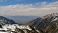
Hidden Peak, 10,992ft (3,350m),[9] is the highest point within the Snowbird ski area. Hidden Peak has a subalpine climate (KöppenDfc), bordering on an Alpine climate (KöppenET). There is no weather station at the summit, but this climate table contains interpolated data for an area around the summit.
Climate data for Hidden Peak (Snowbird) 40.5673 N, 111.6337 W, Elevation: 10,502ft (3,201m) (1991–2020 normals)
Snowbird shares Little Cottonwood Canyon with Alta Ski Area to the east, just up the canyon over a ridge that separates the two. Beginning winter 2002, the two resorts offer a joint day pass and a joint season ticket allowing full access all of the terrain on both mountains: 26 ski lifts and tows and a skiable area of 4,700 acres (19km2). The collaboration coincided with the opening of a new lift in Mineral Basin, a large bowl owned by Snowbird on the back of Snowbird's Hidden Peak and Alta's Sugarloaf mountains that had been skiable within the resort since 1999. The installation of Baldy Express in 2002 allowed access to Alta from the Basin. Other access points between the two resorts exist as well. The offer is open to skiers only, as a result of Alta's skiers-only (no snowboarders) policy.
Both areas receive more than 500 inches (1,270cm) of snowfall per year due to lake-effect enhancement from the Great Salt Lake, making them the second snowiest ski areas in the United States (after the ones in the Cascades). In contrast to the humid and wet conditions in the Cascades near the Pacific Ocean, the arid condition of the Great Basin produces very dry and powdery snow, making Snowbird and Alta top global destinations for powder-skiing aficionados. Another benefit of being East of the Great Salt Lake is that salt from the lake provides the condensation nuclei that creates ice pellet snow that doesn't pack like normal snowflakes. Loose powder for days after a snowfall is common. On very windy days the salt is lifted thousands of feet and has been known to coat the windshield of airplanes flying into Salt Lake City.
Snowbird usually closes on Memorial Day in late May while the occasional ski year can last as long as the Fourth of July on the upper part of the mountain (accessed by the aerial tram), perennially offering the longest ski season in Utah. Snowbird, which operates primarily on privately owned land, has a skiable area of 2,500 acres (10.1km2) with a vertical drop of 3,240 feet (988m) from the summit of Hidden Peak, which has an elevation of above 11,000 feet (3,353m). Hidden Peak is serviced by an aerial tram from the base area.
The resort covers three drainage areas: Peruvian Gulch, Gad Valley, and Mineral Basin. Snowbird is perennially celebrated by industry magazines for its exceptional snowfall, vast and wide-ranging terrain and easy accessibility from the Salt Lake City International Airport.
Snowbird set a resort record of 776 inches (1,971cm) of cumulative snow (mid-mountain measurement) in May 2011. Snowbird is known for its particularly challenging terrain, with most ski runs having a difficulty of "intermediates only" or higher. The most difficult part of the mountain is the cirque traverse, which contains all runs for experts only.
Snowbird currently has 10 chairlifts (6 high-speed quads, 4 doubles), a surface lift, an aerial tram, and a 600-foot (180m) tunnel enclosing a one-way conveyor lift connecting Peruvian Gulch to Mineral Basin allowing easier access for beginners and intermediates to new terrain. The tunnel, the only of its kind in North America, also allows for skier transport when winds require the closing of the aerial tram. The tunnel connects the front half of the resort to Mineral Basin, which is the back half of the mountain. Inside of the tunnel, there are also pictures with descriptions about the history of the tunnel's construction.
Video of the Peruvian Tunnel
Facilities
The Aerial Tram
The resort lodging includes: the Iron Blosam, the Inn, the Lodge at Snowbird, the Cliff Lodge and the Cliff Club. The resort also has gift shops, restaurants, arcades, hiking trails, pools and a rooftop spa. The summit restaurant was built atop Hidden Peak during the summer of 2015.
The resort has 50,000 square feet (4,600m2) of meeting space, with 31 meeting rooms and a 15,000-square-foot (1,400m2) Event Center available in the summer.
Summer activities
While being widely known as a ski resort, Snowbird is also open during the summer. Throughout the warmer months, Snowbird offers activities such as: Alpine Slide, Mountain Coaster, Summer Tubing, Vertical Drop, and Ropes Courses.
The Alpine Slide is a course that runs down the Chickadee ski slope and includes twists, turns, and tunnels. The Mountain Coaster is a wheeled cart track that fits up to two riders. It sits near the base of the Peruvian Express chairlift outside the Snowbird Center. Summer Tubing is the warm weather version of snow tubing and is available to the east of Chickadee by the entrance of the Cliff Lodge. The Vertical Drop is a 50-foot tower drop ride located near the top of Chickadee. The Ropes Course, located near Chickadee bowl, allows participants to be strapped into a harness and walk high above ground. Other activities include hiking and mountain biking.[11]
Awards
Skiing Magazine ranked the Alta-Snowbird ski area second in North America overall and first in the United States for the 2003–04 and 2004–05 seasons. According to SKI Magazine (October 2002) Snowbird ranked 20th in North America with gold medals in snow, access, challenge, terrain, scenery, weather, and lifts. In specific categories it was ranked third in North America for snow, fourth in North America for challenge, and fifth in North America for terrain. Snowbird ranks as the second best resort in North America, runner-up to Whistler Blackcomb resort in Canada, according to Skiing Magazine. In 2008, Outside named Alta-Snowbird the number one ski destination in North America. More recently, ZRankings ranked Snowbird as the fourth best ski resort in North America. Snowbird's snowfall and weather is also considered to be amongst the best in the world for skiing; ZRankings rated Snowbird's snow as the second best in North America (behind its next-door neighbor, Alta).[12] Two of Snowbird's mountain school instructors, Rob Sogard and Nancy Thoreson, made SKI Magazine's Top 100 list.
Snowbird, Utah tram top station, mechanical details
↑"PRISM Climate Group, Oregon State University". PRISM Climate Group, Oregon State University. Retrieved November 6, 2023. To find the table data on the PRISM website, start by clicking Coordinates (under Location); copy Latitude and Longitude figures from top of table; click Zoom to location; click Precipitation, Minimum temp, Mean temp, Maximum temp; click 30-year normals, 1991-2020; click 800m; click Retrieve Time Series button.
This page is based on this Wikipedia article Text is available under the CC BY-SA 4.0 license; additional terms may apply. Images, videos and audio are available under their respective licenses.