Bingham Canyon, Utah

Last updated

Bingham Canyon
Bingham Canyon, Utah, in 1914.jpg
Bingham Canyon in 1914
USA Utah location map.svg
Red pog.svg
Bingham Canyon
Location of Bingham Canyon within the State of Utah
Usa edcp location map.svg
Red pog.svg
Bingham Canyon
Bingham Canyon (the United States)
Coordinates: 40°33′30″N112°07′50″W / 40.55833°N 112.13056°W / 40.55833; -112.13056
Country United States
State Utah
County Salt Lake
Founded1863
Incorporated February 29, 1904
Became a cityMay 23, 1938
Abandoned1972
Named for Thomas and Sanford Bingham
Elevation
[1]
5,938 ft (1,810 m)
GNIS feature ID1425580 [1]

Bingham Canyon was a city formerly located in southwestern Salt Lake County, Utah, United States, in a narrow canyon on the eastern face of the Oquirrh Mountains. The Bingham Canyon area boomed during the first years of the twentieth century, as rich copper deposits in the canyon began to be developed, and at its peak the city had approximately 15,000 residents. The success of the local mines eventually proved to be the town's undoing, however: by the mid-twentieth century, the huge open-pit Bingham Canyon Mine began encroaching on the land of the community, causing residents to relocate. By the 1970s, almost the entirety of the town had been devoured by the mine, and the few remaining residents voted to disincorporate and abandon the community. No trace of Bingham Canyon remains today. [2]

Contents

History

Plat E, Bingham Townsite Map, 1900 from the Salt Lake County Recorder's Bingham Canyon Maps Plat E, Bingham Townsite Map, 1900 from the Salt Lake County Recorder's Bingham Canyon Maps.png
Plat E, Bingham Townsite Map, 1900 from the Salt Lake County Recorder's Bingham Canyon Maps

The geographic feature known as Bingham Canyon received its name from the location's two first settlers, the brothers Thomas and Sanford Bingham, who arrived in the canyon in 1848. Initially, the area was utilized for livestock grazing and logging, but the region's economic focus changed with the 1863 discovery of rich gold and silver ore bodies in the canyon. Mining activity in Bingham Canyon boomed after the Bingham Canyon and Camp Floyd Rail Road completed a line to the canyon in 1873, and as the region grew the focus shifted to the high-quality copper ores in the district. As the mines grew, the town of Bingham also expanded, spreading along the narrow and steep canyon floor below the mines.

The Bingham Canyon mines experienced their greatest boom during the first years of the twentieth century, as the district's smaller mines were consolidated under large corporate ownership. The most significant development occurred in 1903, when Daniel C. Jackling organized the Utah Copper Company to begin surface mining at Bingham Canyon. The Utah Copper Company's mine prospered, and this brought a tremendous influx of new residents into the canyon. The town of Bingham Canyon was officially incorporated on February 29, 1904. [2]

Plat Map of the proposed Bingham Canyon town when the town filed for incorporation with Salt Lake County,1904. Plat Map of the proposed Bingham Canyon twon as part of the incorporation records, 1904.tif
Plat Map of the proposed Bingham Canyon town when the town filed for incorporation with Salt Lake County,1904.
Petition of the Electors of Bingham for Incorporation for the Town of Bingham Canyon, submitted to the Salt Lake County Commission, January 2, 1904. Petition of the Electors of Bingham for Incorporation for the Town of Bingham Canyon, January 2, 1904.pdf
Petition of the Electors of Bingham for Incorporation for the Town of Bingham Canyon, submitted to the Salt Lake County Commission, January 2, 1904.

By the 1920s, the city of Bingham Canyon was at its peak, with perhaps 15,000 inhabitants. Urban development spread for some seven miles along the single, narrow road winding up the steep canyon floor.

As with many western mining towns, the Bingham Canyon area evolved into a collection of diverse neighborhoods, many with pronounced ethnic affiliations. Many Scandinavians lived in the Carr Fork area, while southern and eastern Europeans congregated in Highland Boy, which was in another branch canyon toward the top of the main city. As the mainstreet in the bottom of the canyon grew, Copperfield became the name of the upper section of the main town. Bingham itself attracted British, French, Irish, Puerto Rican, Mexican, and other immigrants and ethnicities. Numerous other small neighborhoods and communities also existed. Most took the name of the mine where they were located. Commercial, Boston Con, and "the Niagara" were the first three communities to be mined away or covered, as the last one was by Galena Gulch waste dumps. Others were the Galena, Old Jordan, and Silver Shield (these three found in Galena Gulch), along with Niagara. Telegraph was in the upper part of the canyon, along with Copperfield, which was threatened when the mining excavating was expanded and a long one-way tunnel was built before 1940 to allow traffic to reach the upper communities. Many names were colorful: Terrace Heights, Dinkeyville, Jap Camp, and Greek camp were sections of Copperfield. The Frisco, Yampa, Phoenix, and Apex were in Carr Fork along with Highland Boy. Further down the canyon were Markham, Freeman, and Frog Town (lower Bingham).

A plat of Bingham Canyon showing Main St. circa 1962. Sheet 3 from Salt Lake County Recorder Plat Maps, Bingham Plat A, 1962-1963, Reel 09137, Record Series RC-052.jpg
A plat of Bingham Canyon showing Main St. circa 1962.

The size and importance of the Bingham community began to fade as early as the 1920s. The canyon's difficult geography made urban development difficult, while exposing the town to the hazards of fire and avalanche. The first effort to reduce settlement in the canyon came in 1926, when Utah Copper established the town of Copperton on the flats east of the canyon mouth. This was a lovely community with many copper products used in the building of the houses, and the low rent encouraged company employees to live there. In 1956, Kennecott sold the homes to employees for $4,800 to $6,000. Increasing mechanization at the mine also reduced local employment—and hence, Bingham Canyon's population.

On 17 February 1926, seventy-nine people were killed when a snow avalanche destroyed a mining camp in the area. [3]

By the 1930s it was becoming apparent that the most significant threat to the town of Bingham was the mine itself, whose ever-expanding open pit began encroaching on lands formerly occupied by miners' neighborhoods. The mine continued to eat away at Bingham throughout the middle years of the twentieth century, and by 1971 little of the town remained. That November, Bingham Canyon's 31 remaining residents voted 112 to disincorporate the town, [2] and the last buildings at Bingham were razed in 1972. Today, most of the land once occupied by Bingham has been consumed by the Bingham Canyon Mine.

Panorama of Bingham Canyon, 1925. Photo courtesy of Utah State Historical Society. Full-size image BCpanorama.jpeg
Panorama of Bingham Canyon, 1925. Photo courtesy of Utah State Historical Society. Full-size image

Climate

Climate is characterized by relatively high temperatures and evenly distributed precipitation throughout the year. This climate type is found on the eastern sides of the continents between 20° and 35° N and S latitude. The Köppen Climate Classification subtype for this climate is "Cfa" (Humid Subtropical Climate). [4]

Notable people

See also

Related Research Articles

<span class="mw-page-title-main">Salt Lake County, Utah</span> County in Utah, United States

Salt Lake County is located in the U.S. state of Utah. As of the 2020 United States census, the population was 1,185,238, making it the most populous county in Utah. Its county seat and largest city is Salt Lake City, the state capital. The county was created in 1850. Salt Lake County is the 37th most populated county in the United States and is one of four counties in the Rocky Mountains to make it into the top 100. Salt Lake County has been the only county of the first class in Utah – under the Utah Code is a county with a population of 700,000 or greater. Although, Utah County directly to the south has recently reached this threshold.

<span class="mw-page-title-main">Alta, Utah</span> Town in Utah, United States

Alta is a town in eastern Salt Lake County, Utah, United States. It is part of the Salt Lake City, Utah Metropolitan Statistical Area. The population was 228 at the 2020 census, a large decrease from the 2010 figure of 383.

<span class="mw-page-title-main">Magna, Utah</span> Metro Township in Utah, United States

Magna is a metro township in Salt Lake County, Utah, United States. The current population of the township stands at 29,251 according to the 2020 census, a 10.4% increase over 26,505 in 2010.

<span class="mw-page-title-main">Tooele, Utah</span> City in Utah, United States

Tooele is a city in Tooele County in the U.S. state of Utah. The population was 35,742 at the 2020 census. It is the county seat of Tooele County. Located approximately 40 minutes southwest of Salt Lake City, Tooele is known for Tooele Army Depot, for its views of the nearby Oquirrh Mountains and the Great Salt Lake.

<span class="mw-page-title-main">Jordan River (Utah)</span> River feeding the Great Salt Lake, US

The Jordan River is a 51.4-mile-long (82.7 km) river in the U.S. state of Utah. Regulated by pumps at its headwaters at Utah Lake, it flows northward through the Salt Lake Valley and empties into the Great Salt Lake. Four of Utah's six largest cities border the river: Salt Lake City, West Valley City, West Jordan, and Sandy. More than a million people live in the Jordan Subbasin, part of the Jordan River watershed that lies within Salt Lake and Utah counties. During the Pleistocene, the area was part of Lake Bonneville.

<span class="mw-page-title-main">Samuel Newhouse</span>

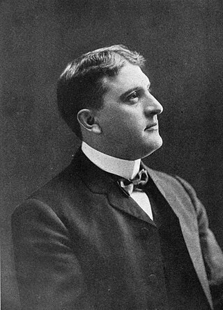
Samuel Newhouse was a Utah entrepreneur and mining magnate.

<span class="mw-page-title-main">Oquirrh Mountains</span> Mountain range in Utah, USA

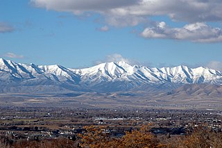
The Oquirrh Mountains is a mountain range that runs north–south for approximately 30 miles (50 km) to form the west side of Utah's Salt Lake Valley, separating it from Tooele Valley. The range runs from northwestern Utah County–central & eastern Tooele County, to the south shore of the Great Salt Lake. The highest elevation is Flat Top Mountain at 10,620 ft. The name Oquirrh was taken from the Goshute word meaning "wood sitting."

<span class="mw-page-title-main">Kennecott Utah Copper</span> Major copper mining and refining company

Kennecott Utah Copper LLC (KUC), a division of Rio Tinto Group, is a mining, smelting, and refining company. Its corporate headquarters are located in South Jordan, Utah. Kennecott operates the Bingham Canyon Mine, one of the largest open-pit copper mines in the world in Bingham Canyon, Salt Lake County, Utah. The company was first formed in 1898 as the Boston Consolidated Mining Company. The current corporation was formed in 1989. The mine and associated smelter produce 1% of the world's copper.

<span class="mw-page-title-main">Hiawatha, Utah</span> Unincorporated Community in Utah, United States

Hiawatha is an unincorporated community and near-ghost town, formerly a coal mining town in southwestern Carbon County, Utah, United States. While the town's former corporate limits were almost entirely within Carbon County, the western part was within the Manti-La Sal National Forest and a very small part extended west into Emery County.

<span class="mw-page-title-main">Copperton, Utah</span> Metro Township in Utah, United States

Copperton is a metro township in Salt Lake County, Utah, United States, located at the mouth of Bingham Canyon, approximately 17 miles (27 km) southwest of Salt Lake City. The metro township boundaries include a smaller area than that of both the former CDP and the former township. Much of the town is included in the Copperton Historic District, which is listed on the National Register of Historic Places.

<span class="mw-page-title-main">F. Augustus Heinze</span> American mining magnate (1869–1914)

Frederick "Fritz" Augustus Heinze was an American businessman, known as one of the three Copper Kings of Butte, Montana, along with William Andrews Clark and Marcus Daly. Contemporary assessments variously described him as an intelligent, charismatic but also devious character. To some people in Montana, he was seen as a hero for standing up to the Amalgamated Copper Company, but he also eventually sold his Butte interests to Amalgamated for a reported $12 million. Thereafter, he played a significant role in the Panic of 1907, for which he was indicted but eventually exonerated. Ultimately, Heinze's flamboyant, hard-drinking lifestyle resulted in a hemorrhage of the stomach thought to be caused by cirrhosis of the liver, and he died in November 1914, aged 44.

<span class="mw-page-title-main">Bingham Canyon Mine</span> Worlds largest open-pit copper mine, located in Utah, United States

The Bingham Canyon Mine, more commonly known as Kennecott Copper Mine among locals, is an open-pit mining operation extracting a large porphyry copper deposit southwest of Salt Lake City, Utah, in the Oquirrh Mountains. The mine is the largest man-made excavation, and deepest open-pit mine in the world, which is considered to have produced more copper than any other mine in history – more than 19,000,000 short tons. The mine is owned by Rio Tinto Group, a British-Australian multinational corporation. The copper operations at Bingham Canyon Mine are managed through Kennecott Utah Copper Corporation which operates the mine, a concentrator plant, a smelter, and a refinery. The mine has been in production since 1906, and has resulted in the creation of a pit over 0.75 miles (1,210 m) deep, 2.5 miles (4 km) wide, and covering 1,900 acres. It was designated a National Historic Landmark in 1966 under the name Bingham Canyon Open Pit Copper Mine. The mine experienced a massive landslide in April 2013 and a smaller slide in September 2013.

Harkers Canyon is located 20 km (12 mi) west-southwest of downtown Salt Lake City, in Salt Lake County, Utah, US. The canyon empties into the Salt Lake Valley from its origin in the Oquirrh Mountains. The canyon is oriented primarily from southwest to northeast, with the middle third of the canyon descending from west to east. Harkers Canyon and surrounding land are owned and managed by the Kennecott Utah Copper Corporation and has been mined for copper.
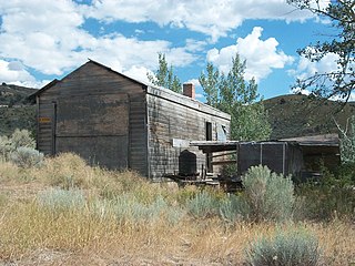
<span class="mw-page-title-main">Daniel C. Jackling</span> Mining engineer (1869–1956)

Daniel Cowan Jackling , was an American mining and metallurgical engineer who pioneered the exploitation of low-grade porphyry copper ores at the Bingham Canyon Mine, Utah.

<span class="mw-page-title-main">Mammoth, Utah</span> Unincorporated community in Utah, United States

Mammoth is an unincorporated community and semi-ghost town in northeastern Juab County, Utah, United States.

Lark is a ghost town located 4 miles (6.4 km) west of Herriman in the Oquirrh Mountains of southwest Salt Lake County, Utah, United States. Lark was the location of several copper mines.

The Kennecott Utah Copper rail line was an electric railroad in Salt Lake County, Utah. It was managed by the Kennecott Utah Copper Corporation and connected the Bingham Canyon Mine with its smelter at Garfield. The rail line has been replaced by a system of conveyors and a 17-mile-long (27 km) slurry pipeline. Current rail operations by Kennecott Utah Copper LLC only occur in the area of the smelter, on a remnant of what was a vast rail network.

The economy of Utah is a diversified economy covering industries such as tourism, mining, agriculture, manufacturing, information technology, finance, and petroleum production. The majority of Utah's gross state product is produced along the Wasatch Front, containing the state capital Salt Lake City.

The Bingham Canyon Reclamation Project, in Utah, was a 1973 site-specific mine reclamation design that artist Robert Smithson submitted to the mine's management company, Kennecott Copper Corporation. The design re-imagined Bingham Canyon Mine, the world's largest open pit mine, as a monumental work of land art.

<span class="mw-page-title-main">International Smelting and Refining Company</span> Former ore refining facility in Tooele County, Utah, United States

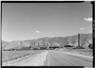
The International Smelting and Refining Company was a subsidiary of Anaconda Copper that operated primarily out of the International Smelter near Tooele, Utah. The International Smelter began operation in 1910 as a copper producer handling ores from Bingham Canyon and was expanded into a lead smelting operation in 1912. Copper smelting finished at International in 1946, and the lead smelter shut down in January 1972. The closure of the smelter would lead to the associated Tooele Valley Railway to be shut down ten years later in 1982. The company also handled several other Anaconda owned interests. After the shut down of several of the International Smelting sites, environmental reclamation has been performed by Anaconda Copper's successor company ARCO and the EPA Superfund program.

References

  1. 1 2 U.S. Geological Survey Geographic Names Information System: Bingham Canyon
  2. 1 2 3 "City of Bingham Canyon". Utah Division of State Archives. Salt Lake City, UT. July 2, 2003. Retrieved May 5, 2017.
  3. ""Disasters"". Powell Valley News. January 7, 1927. Retrieved August 21, 2023.
  4. "Bingham Canyon, Utah Köppen Climate Classification (Weatherbase)". Weatherbase. Retrieved August 23, 2017.
  5. Carey, Benedict (July 13, 2017). "Keith Conners, Psychologist Who Set Standard for Diagnosing A.D.H.D., Dies at 84" . Retrieved August 23, 2017 via NYTimes.com.
  6. Haymond, Jay M. "David Daniel Marriott". Utah.gov. Retrieved February 1, 2020.
  7. "City of Bingham Canyon". Miner Details: The official site of Bingham High School Alumni & Friends. Retrieved September 2, 2023.

http://www.ghosttowns.com/states/ut/copperfield.html

http://eldonbray.blogspot.com/2012/04/small-towns-in-bingham-canyon.html

http://www.kennecott.com/library/media/2007_Educators_Brochure.pdf

Bibliography

Further reading

Commons-logo.svg Media related to Bingham Canyon, Utah at Wikimedia Commons