Grand County | |
---|---|
Coordinates: 38°59′N109°34′W / 38.99°N 109.56°W | |
Country | United States |
State | Utah |
Founded | March 13, 1890 |
Named for | Grand River (now the Colorado River) |
Seat | Moab |
Largest city | Moab |
Area | |
• Total | 3,684 sq mi (9,540 km2) |
• Land | 3,672 sq mi (9,510 km2) |
• Water | 12 sq mi (30 km2) 0.3% |
Population (2020) | |
• Total | 9,669 |
• Estimate (2023) | 9,706 |
• Density | 2.6/sq mi (1.0/km2) |
Time zone | UTC−7 (Mountain) |
• Summer (DST) | UTC−6 (MDT) |
Congressional district | 3rd |
Website | www |
Grand County is a county on the east central edge of the U.S. state of Utah, United States. As of the 2020 United States census, the population was 9,669. [1] Its county seat and largest city is Moab. [2]
Grand County is home to one of the nine statewide regional campuses of Utah State University (located in the city of Moab) and serves as a gateway to both Arches and Canyonlands National Parks.
Evidence of indigenous occupation up to 10,000 BCE has been previously discovered in Grand County. The present city of Moab is the site of pueblo farming communities of the 11th and 12th centuries. These groups had already vanished from the area when the first European explorers entered the country, with nomadic Ute tribes inhabiting the area at the time of contact.
The European-based settlement of the area began with the arrival of Mormon pioneers in 1847. By 1855 they had sent missionary settlers into eastern Utah Territory. An Elk Mountain Mission was established but closed after a few months due to Indian raids. For several decades after that, the future Moab area (known as "Spanish Valley") was visited only by trappers and prospectors. Permanent settlement began in 1877. These early settlers, coming in from the north, encountered the deep canyon walls of the Grand River and could not take wagons over or around the steep canyon walls.
They unloaded their supplies, dismantled the wagons, and lowered them by rope to the river valley. They then drove their oxen over a canyon rim, down deep sand dunes. After the wagons were reassembled and supplies reloaded, they made their way through the deep sand to the river. They found a place to ford the river below the present bridge in north Moab. They later established a ferry at the crossing site, which remained in use until the first bridge was built in 1921.
In 1881 the area was known as Grand Valley, and Moab was a "wild west" town. A 1991 visitor to Moab later said it was the toughest town in Utah because the area and surrounding country have many deep canyons, rivers, mountains, and wilderness areas, becoming a hideout for outlaws. The local economy was initially based on farming and livestock. Mining came in at the end of the 19th century, and the railroad arrived. The first school in the county was started in 1881. Mormon settlers began planting fruit trees by 1879, and by 1910 Moab was a significant fruit-production center.
Due to the distances involved, the settlers of eastern Emery County found it difficult to conduct county business in that county's seat. By March 13, 1890, their petitions caused the Utah Territory legislature to designate the eastern portion of the county as a separate entity, to be named Grand County, named for the Grand River (whose name was changed to Colorado River in 1921). The county boundaries were adjusted in 1892 and in 2003.
Exploration for deep petroleum deposits began in the 1920s, and this industry has significantly contributed to the economy since that time. Other significant industries include uranium mining and filmmaking. [3]
Grand County lies on the east side of Utah. Its east border abuts the west border of the state of Colorado. The Green River flows southward through the eastern part of central Utah, and its meandering course defines the western border of Grand County. The Colorado River enters the east side of Grand County from Colorado, flowing southwestward toward its confluence with the Green in San Juan County, south of Grand. The Dolores River also enters Grand County from Colorado, flowing westward to its confluence with the Colorado River near Dewey.
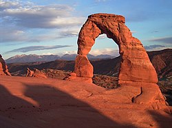
Grand County terrain is arid, rough, and spectacularly carved by water and wind erosion, exposing red rock formations that have created a solid tourist industry. The area is little used for agriculture unless irrigation is available. [4] The terrain is filled with hills and protuberances, but generally slopes to the south and to the west. Its highest point is Mount Waas in the SE part of the county, at 12,336 ft (3,760 m) ASL. [5] The county has a total area of 3,684 square miles (9,540 km2), of which 3,672 square miles (9,510 km2) is land and 12 square miles (31 km2) (0.3%) is water. [6] Deserts, cliffs and plateaus make up the scenery, with few settlements apart from the city of Moab, a Colorado River oasis. Arches National Park lies in the southern part of the county, just north of Moab. A northern portion of Canyonlands National Park lies in the southwest corner of the county.
Census | Pop. | Note | %± |
---|---|---|---|
1890 | 541 | — | |
1900 | 1,149 | 112.4% | |
1910 | 1,595 | 38.8% | |
1920 | 1,808 | 13.4% | |
1930 | 1,813 | 0.3% | |
1940 | 2,070 | 14.2% | |
1950 | 1,903 | −8.1% | |
1960 | 6,345 | 233.4% | |
1970 | 6,688 | 5.4% | |
1980 | 8,241 | 23.2% | |
1990 | 6,620 | −19.7% | |
2000 | 8,485 | 28.2% | |
2010 | 9,225 | 8.7% | |
2020 | 9,669 | 4.8% | |
US Decennial Census [10] 1790–1960 [11] 1900–1990 [12] 1990–2000 [13] 2010 [14] 2020 [15] |
According to the 2020 United States census [16] and 2020 American Community Survey, [17] there were 9,669 people in Grand County with a population density of 2.6 people per square mile (1.0/km2). Among non-Hispanic or Latino people, the racial makeup was 7,481 (77.4%) White, 65 (0.7%) African American, 330 (3.4%) Native American, 80 (0.8%) Asian, 11 (0.1%) Pacific Islander, 62 (0.6%) from other races, and 414 (4.3%) from two or more races. 1,226 (12.7%) people were Hispanic or Latino.
There were 4,810 (49.75%) males and 4,859 (50.25%) females, and the population distribution by age was 2,047 (21.2%) under the age of 18, 5,823 (60.2%) from 18 to 64, and 1,799 (18.6%) who were at least 65 years old. The median age was 40.5 years.
There were 4,006 households in Grand County with an average size of 2.41 of which 2,416 (60.3%) were families and 1,590 (39.7%) were non-families. Among all families, 1,676 (41.8%) were married couples, 260 (6.5%) were male householders with no spouse, and 480 (12.0%) were female householders with no spouse. Among all non-families, 1,206 (30.1%) were a single person living alone and 384 (9.6%) were two or more people living together. 1,123 (28.0%) of all households had children under the age of 18. 2,632 (65.7%) of households were owner-occupied while 1,374 (34.3%) were renter-occupied.
The median income for a Grand County household was $56,639 and the median family income was $68,216, with a per-capita income of $30,948. The median income for males that were full-time employees was $47,736 and for females $36,180. 14.0% of the population and 11.5% of families were below the poverty line.
In terms of education attainment, out of the 7,137 people in Grand County 25 years or older, 442 (6.2%) had not completed high school, 1,931 (27.1%) had a high school diploma or equivalency, 2,576 (36.1%) had some college or associate degree, 1,233 (17.3%) had a bachelor's degree, and 955 (13.4%) had a graduate or professional degree.
Grand County has the lowest percentage of members of the Church of Jesus Christ of Latter-day Saints (LDS Church) among all Utah counties. About 26% of Grand County residents identify as Latter-day Saints, significantly lower than the 62% of Utah as a whole. [18]
Historically, following the period of William Jennings Bryan and Woodrow Wilson, Grand County has generally voted Republican. Between 1920 and 1988 (inclusive), it voted Democratic only four times: thrice for Franklin Roosevelt, and once for Lyndon Johnson. However, it has become a swing county recent years, voting Democratic thrice in the last nine presidential elections (for Bill Clinton in 1992, Barack Obama in 2008, Joe Biden in 2020, and Kamala Harris in 2024). The highest vote share any Republican has received in the county in the last nine elections was 51.1% (by George W. Bush in 2004); Joe Biden's 53.9% was the highest vote share for any nominee of either party since 1988, as well as the highest for a Democrat in the county since 1936. In 2024, Kamala Harris became the first Democratic presidential nominee to win Grand County despite losing the presidential election since 1900.
Grand County is one of only thirteen counties to have voted for Obama in 2008, Romney in 2012, Trump in 2016, and Biden in 2020. [a]
Position | District | Name | Affiliation | First elected | |
---|---|---|---|---|---|
Senate | 27 | David Hinkins | Republican | 2008 [19] | |
House of Representatives | 69 | Christine Watkins | Republican | 2016 [20] | |
House of Representatives | 70 | Carl Albrecht | Republican | 2016 [21] | |
Board of Education | 14 | Mark Huntsman | Nonpartisan | 2014 [22] | |
Year | Republican | Democratic | Third party(ies) | |||
---|---|---|---|---|---|---|
No. | % | No. | % | No. | % | |
2024 | 2,327 | 43.70% | 2,828 | 53.11% | 170 | 3.19% |
2020 | 2,248 | 43.19% | 2,806 | 53.91% | 151 | 2.90% |
2016 | 1,975 | 42.93% | 1,960 | 42.60% | 666 | 14.48% |
2012 | 1,996 | 50.53% | 1,727 | 43.72% | 227 | 5.75% |
2008 | 1,871 | 45.65% | 2,067 | 50.43% | 161 | 3.93% |
2004 | 2,130 | 51.14% | 1,858 | 44.61% | 177 | 4.25% |
2000 | 1,822 | 50.42% | 1,158 | 32.04% | 634 | 17.54% |
1996 | 1,384 | 42.57% | 1,199 | 36.88% | 668 | 20.55% |
1992 | 1,100 | 32.91% | 1,160 | 34.71% | 1,082 | 32.38% |
1988 | 1,895 | 58.34% | 1,287 | 39.62% | 66 | 2.03% |
1984 | 2,463 | 73.15% | 876 | 26.02% | 28 | 0.83% |
1980 | 2,362 | 70.42% | 703 | 20.96% | 289 | 8.62% |
1976 | 1,781 | 62.38% | 931 | 32.61% | 143 | 5.01% |
1972 | 1,837 | 72.15% | 560 | 22.00% | 149 | 5.85% |
1968 | 1,435 | 60.88% | 707 | 30.00% | 215 | 9.12% |
1964 | 1,130 | 49.67% | 1,145 | 50.33% | 0 | 0.00% |
1960 | 1,130 | 58.40% | 805 | 41.60% | 0 | 0.00% |
1956 | 1,044 | 76.09% | 328 | 23.91% | 0 | 0.00% |
1952 | 675 | 72.27% | 259 | 27.73% | 0 | 0.00% |
1948 | 418 | 50.54% | 400 | 48.37% | 9 | 1.09% |
1944 | 428 | 52.64% | 380 | 46.74% | 5 | 0.62% |
1940 | 432 | 49.04% | 446 | 50.62% | 3 | 0.34% |
1936 | 272 | 33.62% | 521 | 64.40% | 16 | 1.98% |
1932 | 278 | 34.53% | 506 | 62.86% | 21 | 2.61% |
1928 | 347 | 52.58% | 310 | 46.97% | 3 | 0.45% |
1924 | 278 | 47.93% | 243 | 41.90% | 59 | 10.17% |
1920 | 306 | 51.17% | 278 | 46.49% | 14 | 2.34% |
1916 | 213 | 39.52% | 306 | 56.77% | 20 | 3.71% |
1912 | 191 | 33.75% | 212 | 37.46% | 163 | 28.80% |
1908 | 232 | 48.74% | 215 | 45.17% | 29 | 6.09% |
1904 | 262 | 57.21% | 165 | 36.03% | 31 | 6.77% |
1900 | 178 | 46.11% | 204 | 52.85% | 4 | 1.04% |
1896 | 28 | 9.59% | 264 | 90.41% | 0 | 0.00% |
Moab has a significant environmentalist population due to nearby Arches National Park and Canyonlands National Park. [24]
Grand County was an epicenter of the Sagebrush Rebellion, which took place during the late 1970s and early 1980s when residents protested what they saw as overreaching Federal control of Western US land.
An early event in the Rebellion was July 4, 1980, when 300 Grand County residents gathered behind a flag-decorated bulldozer in protest of the inclusion of Mill Creek Canyon as part of a Bureau of Land Management wilderness study area. Despite plowing nearly 200 yards up the canyon, the group did not reach the study area's boundary.
The Denver Museum of Natural History opened a small Cedar Mountain Formation quarry that has produced diverse dinosaur fossils including theropod, sauropod and ornithopod. An adult sauropod was designated the type specimen of the genus Venenosaurus . [25]
Emery County is a county in east-central Utah, United States. As of the 2020 United States Census, the population was 9,825. Its county seat is Castle Dale, and the largest city is Huntington.
Garfield County is a county in south central Utah, United States. As of the 2020 United States Census the population was 5,083, making it the fifth-least populous county in Utah; with about one inhabitant per square mile, it is also the least densely populated county in Utah. Its county seat and largest city is Panguitch.
Millard County is a county in the U.S. state of Utah. As of the 2020 United States Census, the population was 12,975. Its county seat is Fillmore, and the largest city is Delta.
Piute County is a county in south-central Utah, United States. As of the 2020 United States Census, the population was 1,438, making it the second-least populous county in Utah. The county seat is Junction, and the largest town is Circleville.
Rich County is a county in the U.S. state of Utah. As of the 2020 United States Census, the population was 2,510, making it the third-least populous county in Utah. Its county seat is Randolph, and the largest town is Garden City. The county was created in 1864. It was named for an early LDS apostle, Charles C. Rich.
San Juan County is a county in the southeastern portion of the U.S. state of Utah. As of the 2020 United States Census, the population was 14,518. Its county seat is Monticello, while its most populous city is Blanding. The Utah State Legislature named the county for the San Juan River, itself named by Spanish explorers.
Sanpete County is a county in the U.S. state of Utah. As of the 2020 United States Census, the population was 28,437. Its county seat is Manti, and its largest city is Ephraim. The county was created in 1850.
Sevier County is a county in Utah, United States. As of the 2020 United States Census, the population was 21,522. Its county seat and largest city is Richfield.
Tooele County is a county in the U.S. state of Utah. As of the 2020 United States Census, the population was 72,698. Its county seat and largest city is Tooele. The county was created in 1850 and organized the following year.
Uintah County is a county in the U.S. state of Utah. As of the 2020 United States Census the population was 35,620. Its county seat and largest city is Vernal. The county was named for the portion of the Ute Indian tribe that lived in the basin.
Wayne County is a county in the U.S. state of Utah. As of the 2020 census, the population was 2,486, making it the fourth-least populous county in Utah. Its county seat is Loa.
Moab is the largest city and county seat of Grand County in eastern Utah in the western United States, known for its dramatic scenery. The population was 5,366 at the 2020 census. Moab attracts many tourists annually, mostly visitors to the nearby Arches and Canyonlands National Parks. The town is a popular base for mountain bikers who ride the extensive network of trails including the Slickrock Trail, and for off-roaders who come for the annual Moab Jeep Safari.
The Colorado River is one of the principal rivers in the Southwestern United States and in northern Mexico. The 1,450-mile-long (2,330 km) river, the 5th longest in the United States, drains an expansive, arid watershed that encompasses parts of seven U.S. states and two Mexican states. The name Colorado derives from the Spanish language for "colored reddish" due to its heavy silt load. Starting in the central Rocky Mountains of Colorado, it flows generally southwest across the Colorado Plateau and through the Grand Canyon before reaching Lake Mead on the Arizona–Nevada border, where it turns south toward the international border. After entering Mexico, the Colorado approaches the mostly dry Colorado River Delta at the tip of the Gulf of California between Baja California and Sonora.
Canyonlands National Park is a national park of the United States located in southeastern Utah near the town of Moab. The park preserves a colorful landscape eroded into numerous canyons, mesas, and buttes by the Colorado River, the Green River, and their respective tributaries. Legislation creating the park was signed into law by President Lyndon B. Johnson on September 12, 1964.
The Colorado Plateau is a physiographic and desert region of the Intermontane Plateaus, roughly centered on the Four Corners region of the southwestern United States. This plateau covers an area of 336,700 km2 (130,000 mi2) within western Colorado, northwestern New Mexico, southern and eastern Utah, northern Arizona, and a tiny fraction in the extreme southeast of Nevada. About 90% of the area is drained by the Colorado River and its main tributaries: the Green, San Juan, and Little Colorado. Most of the remainder of the plateau is drained by the Rio Grande and its tributaries.
The Manti–La Sal National Forest covers more than 1.2 million acres (4,900 km2) and is located in the central and southeastern parts of the U.S. state of Utah and the extreme western part of Colorado. The forest is headquartered in Price, with ranger district offices in Price, Ferron, Ephraim, Moab and Monticello. The maximum elevation is Mount Peale in the La Sal Mountains, reaching 12,721 feet (3,877 m) above sea level. The La Sal Mountains are the second highest mountain range in Utah after the Uintas. Parts of the forest are included in the Bears Ears National Monument.
State Route 279 is a state highway in the U.S. state of Utah. The highway was constructed in 1962–1963 to service the Cane Creek potash mine and processing plant southwest of Moab. The highway was named one of the most beautiful highways opened to traffic in 1963. The entire length of SR-279 has been designated the Potash – Lower Colorado River Scenic Byway by the Utah State Legislature, however is known locally as Potash Road.
U.S. Route 191 (US-191) is a major 404.168-mile (650.445 km), north–south U.S. Numbered Highway through eastern Utah, United States. The present alignment of US-191, which stretches from Mexico to Canada, was created in 1981 through Utah. Previously the route had entered northern Utah, ending at US-91 in Brigham City, but with the completion of I-15 it was truncated to Yellowstone National Park and re-extended on a completely different alignment. In addition to a large portion of US-163, this extension absorbed several state routes: SR-33, most of SR-44, and SR-260.
The Dinosaur Diamond is a 486-mile (782 km) scenic and historic byway loop through the dinosaur fossil laden Uinta Basin of the U.S. states of Utah and Colorado. The byway comprises the following two National Scenic Byways:
The following is an alphabetical list of articles related to the U.S. state of Utah.