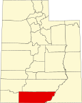
Kane County, Utah

Last updated

Kane County
Narrows in Dianas Throne Canyon - DyeClan.com - panoramio (2).jpg
Narrows in Diana's Throne Canyon, also known as the Huntress Slot in vicinity of Mount Carmel Junction. [2]
Map of Utah highlighting Kane County.svg
Location within the U.S. state of Utah
Utah in United States.svg
Utah's location within the U.S.
Coordinates: 37°17′N111°53′W / 37.29°N 111.89°W / 37.29; -111.89
CountryFlag of the United States.svg United States
StateFlag of Utah.svg  Utah
FoundedJanuary 16, 1864
Named for Thomas L. Kane
Seat Kanab
Largest cityKanab
Area
  Total4,109 sq mi (10,640 km2)
  Land3,990 sq mi (10,300 km2)
  Water118 sq mi (310 km2)  2.9%
Population
 (2020)
  Total7,667
  Density1.9/sq mi (0.72/km2)
Time zone UTC−7 (Mountain)
  Summer (DST) UTC−6 (MDT)
Congressional district 2nd
Website kane.utah.gov
Sunset Arch, Glen Canyon National Recreation Area Sunset Arch.jpg
Sunset Arch, Glen Canyon National Recreation Area

Kane County is a county in the U.S. state of Utah. As of the 2020 United States Census, the population was 7,667. [3] Its county seat and largest city is Kanab. [4]

Contents

History

The county was created on January 16, 1864, by the Utah Territory legislature, with areas partitioned from Washington County. It was named for Col. Thomas L. Kane, [5] a friend of the Latter Day Saint settlers in the 1840s and 1850s. The county boundary was adjusted in 1869, when a portion was returned to Washington County; in 1880, when San Juan County was created; and in 1883, when portions were partitioned from Kane and added to Iron and Washington counties. [6]

Geography

Kane County lies on the south line of the state of Utah. Its south border abuts the northern border of the state of Arizona. The Colorado River, reformed as Lake Powell, forms its eastern border. Grand Staircase–Escalante National Monument covers much of the county. A rugged and inhospitable country of deserts, mountains, and cliffs make up the terrain, with breathtaking scenery in every area. Parts of Bryce Canyon National Park and Zion National Park extend into the northern and western portions of the county. The eastern part of the county is part of the Glen Canyon National Recreation Area. [7] The county has a total area of 4,109 square miles (10,640 km2), of which 3,990 square miles (10,300 km2) is land and 118 square miles (310 km2) (2.9%) is water. [8]

Adjacent counties

Protected areas

Lakes [7]

Demographics

Historical population
CensusPop.Note
1870 1,513
1880 3,085103.9%
1890 1,685−45.4%
1900 1,8117.5%
1910 1,652−8.8%
1920 2,05424.3%
1930 2,2358.8%
1940 2,56114.6%
1950 2,299−10.2%
1960 2,66716.0%
1970 2,421−9.2%
1980 4,02466.2%
1990 5,16928.5%
2000 6,04617.0%
2010 7,12517.8%
2020 7,6677.6%
US Decennial Census [9]
1790–1960 [10] 1900–1990 [11]
1990–2000 [12] 2010 [13] 2020 [14]

2000 census

As of the 2000 United States Census, there were 6,046 people, 2,237 households, and 1,628 families in the county. The population density was 1.52 people per square mile (0.59 people/km2). There were 3,767 housing units at an average density of 0.94 units per square mile (0.36 units/km2). The racial makeup of the county was 96.00% White, 0.03% Black or African American, 1.55% Native American, 0.22% Asian, 0.05% Pacific Islander, 0.74% from other races, and 1.41% from two or more races. 2.32% of the population were Hispanic or Latino of any race. The top 5 ethnic groups in Kane County are:

There were 2,237 households, of which 32.20% had children under 18 living with them, 64.60% were married couples living together, 6.00% had a female householder with no husband present, and 27.20% were non-families. 23.30% of all households were made up of individuals, and 10.20% had someone living alone who was 65 years of age or older. The average household size was 2.67, and the average family size was 3.21.

The county population contained 29.40% under the age of 18, 6.80% from 18 to 24, 21.20% from 25 to 44, 25.90% from 45 to 64, and 16.70% who were 65 years of age or older. The median age was 39 years. For every 100 females, there were 98.30 males. For every 100 females aged 18 and over, there were 94.10 males.

The median income for a household in the county was $34,247, and the median income for a family was $40,030. Males had a median income of $30,655 versus $20,406 for females. The per capita income for the county was $15,455. About 5.50% of families and 7.90% of the population were below the poverty line, including 9.30% of those under age 18 and 5.40% of those aged 65 or over.

Politics and government

Kane is one of the most reliably Republican counties in the nation. Of "straight-ticket" voters in the 2008 election, there were 992 Republicans and 326 Democrats. In the Utah gubernatorial election, 2004 nearly 70% of the county's vote went for Jon Huntsman, Jr. and in the 2008 election he received around 75% of the vote. Kane County is part of Utah's 2nd congressional district and thus was represented by moderate Democrat Jim Matheson for several years until 2013. The second district is now represented by Republican Chris Stewart, elected in 2012 when Jim Matheson ran for election to the newly created fourth district instead of remaining in the second.

In Presidential elections, Kane County has only been won once by a Democratic candidate when Woodrow Wilson carried the county in 1916. It was the only county in Utah carried by Alf Landon, the Republican opponent who lost to Franklin Delano Roosevelt in the 1936 Presidential election in the most lopsided Presidential election in over a century. It has solidly favored the Republican candidate since at least 1956, when Dwight D. Eisenhower received approximately 90% of the vote. In 1964, by over thirty-nine percent, the county went for Barry Goldwater, who lost the overall in the state by over nine percent. Since 1920, only in the Democratic landslides of 1936, 1940, and 1964 did the Democratic candidate for president receive even 30% of the county's vote. [15]

State elected offices
PositionDistrictNameAffiliationFirst elected
  Senate 24 Derrin Owens Republican 2020 [16]
  House of Representatives 73 Phil Lyman Republican 2018 [17]
 Board of Education14Mark HuntsmanNonpartisan2014 [18]
United States presidential election results for Kane County, Utah [15]
Year Republican Democratic Third party
No.%No.%No.%
2020 2,99871.30%1,08325.76%1242.95%
2016 2,26564.02%74120.94%53215.04%
2012 2,52274.81%74422.07%1053.11%
2008 2,21269.65%85626.95%1083.40%
2004 2,41479.12%57618.88%612.00%
2000 2,25480.44%38713.81%1615.75%
1996 1,68272.63%30413.13%33014.25%
1992 1,24157.14%29513.58%63629.28%
1988 1,78879.29%39817.65%693.06%
1984 1,71085.12%29414.63%50.25%
1980 1,49281.35%25613.96%864.69%
1976 1,09472.50%33021.87%855.63%
1972 1,14678.82%21814.99%906.19%
1968 81471.72%14712.95%17415.33%
1964 78469.75%34030.25%00.00%
1960 87680.44%21319.56%00.00%
1956 93990.20%1029.80%00.00%
1952 94385.19%16414.81%00.00%
1948 76977.76%22022.24%00.00%
1944 66273.07%24426.93%00.00%
1940 67566.57%33933.43%00.00%
1936 51956.54%39543.03%40.44%
1932 61871.86%22926.63%131.51%
1928 56679.94%14119.92%10.14%
1924 51580.22%11718.22%101.56%
1920 50172.61%18626.96%30.43%
1916 30446.99%32950.85%142.16%
1912 42675.27%11520.32%254.42%
1908 41579.81%10219.62%30.58%
1904 39979.64%10220.36%00.00%
1900 39270.89%16129.11%00.00%
1896 28855.60%23044.40%00.00%

Communities

Map of Kane County communities Kane County Utah incorporated and unincorporated areas.svg
Map of Kane County communities

City

Towns

Unincorporated communities

Ghost towns

See also

Related Research Articles

<span class="mw-page-title-main">Garfield County, Utah</span> County in Utah, United States

Garfield County is a county in south central Utah, United States. As of the 2020 United States Census the population was 5,083, making it the fifth-least populous county in Utah; with about one inhabitant per square mile, it is also the least densely populated county in Utah. Its county seat and largest city is Panguitch.

<span class="mw-page-title-main">Grand County, Utah</span> County in Utah, United States

Grand County is a county on the east central edge of the U.S. state of Utah, United States. As of the 2020 United States Census, the population was 9,669. Its county seat and largest city is Moab.

<span class="mw-page-title-main">Iron County, Utah</span> County in Utah, United States

Iron County is a county in southwestern Utah, United States. As of the 2020 United States Census, the population was 57,289. Its county seat is Parowan, and the largest city is Cedar City.

<span class="mw-page-title-main">Piute County, Utah</span> County in Utah, United States

Piute County is a county in south-central Utah, United States. As of the 2020 United States Census, the population was 1,438, making it the second-least populous county in Utah. The county seat is Junction, and the largest town is Circleville.

<span class="mw-page-title-main">Morgan County, Utah</span> County in Utah, United States

Morgan County is a county in northern Utah, United States. As of the 2020 census, the population was 12,295. Its county seat and largest city is Morgan. Morgan County is part of the Ogden-Clearfield, UT Metropolitan Statistical Area as well as the Salt Lake City-Provo-Orem, UT Combined Statistical Area.

<span class="mw-page-title-main">San Juan County, Utah</span> County in Utah, United States

San Juan County is a county in the southeastern portion of the U.S. state of Utah. As of the 2020 United States Census, the population was 14,518. Its county seat is Monticello, while its most populous city is Blanding. The Utah State Legislature named the county for the San Juan River, itself named by Spanish explorers.

<span class="mw-page-title-main">Utah County, Utah</span> County in Utah, United States

Utah County is the second-most populous county in the U.S. state of Utah. The county seat and largest city is Provo, which is the state's fourth-largest city, and the largest outside of Salt Lake County. As of the 2020 United States Census, the population was 665,665.

<span class="mw-page-title-main">Coconino County, Arizona</span> County in Arizona, United States

Coconino County is a county in the north-central part of the U.S. state of Arizona. Its population was 145,101 at the 2020 census. The county seat is Flagstaff. The county takes its name from Cohonino, a name applied to the Havasupai people. It is the second-largest county by area in the contiguous United States, behind San Bernardino County, California. It has 18,661 sq mi (48,300 km2), or 16.4% of Arizona's total area, and is larger than the nine smallest states in the U.S.

<span class="mw-page-title-main">Mohave County, Arizona</span> County in Arizona, United States

Mohave County is in the northwestern corner of the U.S. state of Arizona. As of the 2020 census, its population was 213,267. The county seat is Kingman, and the largest city is Lake Havasu City. It is the fifth largest county in the United States.

<span class="mw-page-title-main">Big Horn County, Wyoming</span> County in Wyoming, United States

Big Horn County is a county in the U.S. state of Wyoming. As of the 2020 United States Census, the population was 11,521. The county seat is Basin. Its north boundary abuts the south boundary of Montana.

<span class="mw-page-title-main">Randall County, Texas</span> County in Texas, United States

Randall County is a county located in the U.S. state of Texas. As of the 2020 census, its population was 140,753. Its county seat is Canyon. The county was created in 1876 and later organized in 1889. It is named for Horace Randal, a Confederate brigadier general killed at the Battle of Jenkins Ferry. The reason the county name differs from his is because the bill creating the county misspelled Randal's name.

<span class="mw-page-title-main">Lawrence County, South Dakota</span> County in South Dakota, United States

Lawrence County is a county in the U.S. state of South Dakota. As of the 2020 census, the population was 25,768, making it the 8th most populous county in South Dakota. Its county seat is Deadwood.

<span class="mw-page-title-main">Madison County, Idaho</span> County in Idaho, United States

Madison County is a county located in the U.S. state of Idaho. As of the 2020 census, the population was 52,913. The county seat and largest city is Rexburg.

<span class="mw-page-title-main">Clark County, Idaho</span> County in Idaho, United States

Clark County is a rural county in the U.S. state of Idaho; its county seat and largest city is Dubois. As of the 2020 census, the population was 790, making it the least populous county in the state.

<span class="mw-page-title-main">Rio Blanco County, Colorado</span> County in Colorado, United States

Rio Blanco County is a county located in the U.S. state of Colorado. As of the 2020 census, the population was 6,529. The county seat is Meeker. The name of the county is the Spanish name for the White River which runs through it.

<span class="mw-page-title-main">Montrose County, Colorado</span> County in Colorado, United States

Montrose County is a county located in the U.S. state of Colorado. As of the 2020 census, the population was 42,679. The county seat is Montrose, for which the county is named.

<span class="mw-page-title-main">Montezuma County, Colorado</span> County in Colorado, United States

Montezuma County is a county located in the southwest corner of the U.S. state of Colorado. As of the 2020 census, the population was 25,849. The county seat is Cortez.

<span class="mw-page-title-main">Mesa County, Colorado</span> County in Colorado, United States

Mesa County is a county located in the U.S. state of Colorado. As of the 2020 census, the population was 155,703. The county seat and most populous municipality is Grand Junction. The county was named for the many large mesas in the area, including the Grand Mesa, which is the largest flat-topped mountain in the world.

<span class="mw-page-title-main">Fredonia, Arizona</span> Community in Coconino County, Arizona

Fredonia is a town in Coconino County, Arizona, United States. As of the 2010 census it had a population of 1,314. Fredonia is the gateway to the North Rim of the Grand Canyon.

<span class="mw-page-title-main">Kanab, Utah</span> City in and county seat of Kane County, Utah, United States

Kanab is a city in and the county seat of Kane County, Utah, United States. It is located on Kanab Creek just north of the Arizona state line.

References

  1. Diana's Throne
  2. Diana's Throne
  3. "Kane County, Utah". United States Census Bureau . Retrieved June 30, 2023.
  4. "Find a County". National Association of Counties. Archived from the original on May 31, 2011. Retrieved June 7, 2011.
  5. Gannett, Henry (1905). The Origin of Certain Place Names in the United States. Govt. Print. Off. p.  172.
  6. "[[Newberry Library]]. Individual County Chronologies - Kane County UT (accessed March 25, 2019)". Archived from the original on March 6, 2016. Retrieved March 25, 2019.
  7. 1 2 Kane County UT Google Maps (accessed 25 March 2019)
  8. "2010 Census Gazetteer Files". US Census Bureau. August 22, 2012. Retrieved June 25, 2015.
  9. "US Decennial Census". US Census Bureau. Archived from the original on April 26, 2015. Retrieved June 25, 2015.
  10. "Historical Census Browser". University of Virginia Library. Retrieved June 25, 2015.
  11. Forstall, Richard L., ed. (June 25, 1995). "Population of Counties by Decennial Census: 1900 to 1990". US Census Bureau. Retrieved March 27, 2015.
  12. "Census 2000 PHC-T-4. Ranking Tables for Counties: 1990 and 2000" (PDF). US Census Bureau. April 2, 2001. Retrieved June 25, 2015.
  13. "State & County QuickFacts". United States Census Bureau. Archived from the original on June 6, 2011. Retrieved December 29, 2013.
  14. 2020 Population and Housing State Data | Utah
  15. 1 2 Leip, David. "Atlas of US Presidential Elections". uselectionatlas.org. Retrieved March 31, 2018.
  16. "Senator Owens Utah Senate". senate.utah.gov. Retrieved November 16, 2021.
  17. "Rep. Lyman, Phil". Utah House of Representatives. Retrieved November 15, 2021.
  18. "Mark Huntsman". www.schools.utah.gov. Retrieved November 15, 2021.

37°17′N111°53′W / 37.29°N 111.89°W / 37.29; -111.89