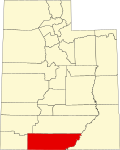
Johnson is a ghost town in Kane County, in the U.S. state of Utah. [1] It is located 12 miles east of the present-day city of Kanab, Utah.
Johnson was founded in 1871 by the four Johnson brothers: Joel, Joseph, Benjamin, and William, and named for them. [2] [3] A post office called Johnson was established in 1871, and remained in operation until 1937. [4]
Kane County is a county in the U.S. state of Utah. As of the 2020 United States Census, the population was 7,667. Its county seat and largest city is Kanab.
Panguitch is a city in and the county seat of Garfield County, Utah, United States. The population was 1,725 at the 2020 census. The name Panguitch comes from a Southern Paiute word meaning “Big Fish,” likely named after the plentiful nearby lakes hosting rainbow trout year-round.
Alton is a town in northwest Kane County, Utah, United States. The population was 119 at the 2010 census, a decrease from the 2000 figure of 134.
Kanab is a city in and the county seat of Kane County, Utah, United States. It is located on Kanab Creek just north of the Arizona state line.
The Pink Cliffs are a series of highly dissected cliffs on the Colorado Plateau in Garfield, Iron, and Kane counties in southwestern Utah, United States. Contrary to the implication of the name, the cliffs are not a single set of rock formations, but actually a geological formation that manifests itself in multiple sets of rock formations.
Buckskin Gulch is a gulch and canyon located in southern Kane County, Utah, near the Arizona border in the Paria Canyon-Vermilion Cliffs Wilderness. With a length of over 16 miles (26 km), it is one of the main tributaries of the Paria River, a tributary of the Colorado River.
Wire Pass Trailhead is a recreation access point in Kane County, Utah that features several trails leading to natural points of interest.
The Arizona Strip is the part of Arizona lying north of the Colorado River. Despite being larger in area than several U.S. states, the entire region has a population of fewer than 10,000 people. Consisting of northeastern Mohave County and northwestern Coconino County, the largest settlements in the Strip are Colorado City, Fredonia, and Beaver Dam, with smaller communities of Scenic, Littlefield and Desert Springs. The Kaibab Indian Reservation lies within the region. Lying along the North Rim of the Grand Canyon creates physical barriers to the rest of Arizona. Only three major roads traverse the region: I-15 crosses the northwestern corner, while Arizona State Route 389 and U.S. Route 89A cross the northeastern part of the strip, and US 89A crosses the Colorado River via the Navajo Bridge, providing the only direct road connection between the strip and the rest of the state. The nearest metropolitan area is the St. George, Utah metro area, to which the region is more connected than to the rest of Arizona.
Cottonwood Canyon Road is a scenic 46-mile (74 km) or 47-mile (76 km) dirt road that traverses Cottonwood Canyon in Kane County, Utah. The drive begins in Cannonville, just off Utah State Route 12, continues southward through Grand Staircase–Escalante National Monument, and eventually connects to U.S. Route 89.
Kanab Creek is one of the many tributaries of the Colorado River. It begins in Kane County, Utah, just south of the watershed to the Great Basin and flows 125 miles (201 km) south to the Colorado River.
Paria or Pahreah, is a ghost town on the Paria River in Grand Staircase–Escalante National Monument in central Kane County, Utah, United States. It was inhabited from 1870 to 1929, and later used as a filming location.
Mollie's Nipple or Molly's Nipple is the name given to as many as seven peaks, at least one butte, at least one well, and some other geological features in Utah. Some sources claim there are eleven geological features in Utah that bear this name. At least some of those names are attributed to John Kitchen – a pioneer of an early exploration of Utah, who named them to commemorate a nipple of his wife Molly.
Hatton, formerly Petersburg, is an unincorporated community and near-ghost town in Millard County, Utah, United States. It lies at an elevation of 4,826 feet.
Buckskin Mountain is a 16-mile (26 km) mountain ridge that spans from Coconino County, Arizona to Kane County, Utah in the United States, that is divided almost equally between the two counties.
Hamblin, now a ghost town, was a Mormon pioneer town along the Mormon Road, from 1856 to 1905. It was located at an elevation of 5,832 feet in Mountain Meadow in western Washington County, Utah, United States.
Slagle is an unincorporated community in Polk County, in the U.S. state of Missouri.
Dividend is an extinct town in southwest Utah County, Utah, United States. The GNIS classifies it as a populated place.
Bacchus is a ghost town in Salt Lake County, Utah, United States.
Benmore is a ghost town in Tooele County, in the U.S. state of Utah.
Hillsdale is a populated place in Garfield County, in the U.S. state of Utah.
37°05′11″N112°22′31″W / 37.08639°N 112.37528°W