Alton, Utah

Last updated

Alton, Utah
Town
Kane County Utah incorporated and unincorporated areas Alton highlighted.svg
Location in Kane County and the state of Utah
Map of USA UT.svg
Location of Utah in the United States
Coordinates: 37°26′16″N112°28′58″W / 37.43778°N 112.48278°W / 37.43778; -112.48278 [1]
Country United States
State Utah
County Kane
Founded1907
Incorporated 1935
Named for Alton Fjord
Area
[2]
  Total2.33 sq mi (6.02 km2)
  Land2.29 sq mi (5.93 km2)
  Water0.04 sq mi (0.10 km2)
Elevation
[1]
7,041 ft (2,146 m)
Population
 (2010)
  Total119
  Estimate 
(2019) [3]
120
  Density52.45/sq mi (20.25/km2)
Time zone UTC-7 (MST)
  Summer (DST) UTC-6 (MDT)
ZIP code
84710
Area code 435
FIPS code 49-00870 [4]
GNIS feature ID1438182 [1]

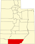
Alton is a town in northwest Kane County, Utah, United States. The population was 119 at the 2010 census, [5] a decrease from the 2000 figure of 134.

Contents

History

Alton was first settled by Lorenzo Wesley Roundy in 1865 and was originally called "Roundys Station". [6] [7] Roundy's family was forced to leave due to conflicts with the local indigenous tribes. The community was later called "Graham", after Graham Duncan McDonald, a local pioneer. Over the years, many names have been discussed, but a consensus could not be reached. In 1912, a drawing was held at a community event to determine the community's name. Charles R. Pugh, who had been reading about the Alton Fjord in Norway, suggested the name, and it was pulled from the hat by a two-year-old child.

Dustin Cox currently serves as Alton's Mayor and has been in the position for some time. He will likely run unopposed in the town's next election.

Demographics

Historical population
CensusPop.Note
1900 106
1910 98−7.5%
1920 16972.4%
1930 19314.2%
1940 23923.8%
1950 154−35.6%
1960 116−24.7%
1970 62−46.6%
1980 7521.0%
1990 9324.0%
2000 13444.1%
2010 119−11.2%
2019 (est.)120 [3] 0.8%
U.S. Decennial Census [8]

As of the census of 2010, there were 119 people in 39 households in the town. The racial makeup of the town was 89% white, 5% Hispanic or Latino, and 2.5% Native American.

The population was 45 percent male and 55 percent female. The population was 38.7 percent under 18 and 20 percent 65 or over.

Geography

Alton is in northwestern Kane County, in a sloping valley known as the "Alton Amphitheater", 4 miles (6 km) east of U.S. Route 89 along Utah State Route 136. Kanab Creek flows past the east side of the community. [9]

According to the United States Census Bureau, the town has a total area of 2.1 square miles (5.5 km2), of which 0.04 square miles (0.1 km2), or 1.74%, are water. [5]

Climate

Alton has a warm-summer continental climate (Köppen Dsb).

Climate data for Alton, Utah, 1991–2020 normals, extremes 1915–present
MonthJanFebMarAprMayJunJulAugSepOctNovDecYear
Record high °F (°C)64
(18)
68
(20)
76
(24)
81
(27)
90
(32)
96
(36)
101
(38)
97
(36)
93
(34)
85
(29)
77
(25)
67
(19)
101
(38)
Mean daily maximum °F (°C)41.3
(5.2)
43.4
(6.3)
51.5
(10.8)
60.0
(15.6)
69.4
(20.8)
80.5
(26.9)
85.3
(29.6)
83.1
(28.4)
75.9
(24.4)
64.1
(17.8)
51.2
(10.7)
41.0
(5.0)
62.2
(16.8)
Daily mean °F (°C)29.6
(−1.3)
31.4
(−0.3)
38.0
(3.3)
44.5
(6.9)
52.3
(11.3)
61.7
(16.5)
68.2
(20.1)
66.6
(19.2)
59.4
(15.2)
48.8
(9.3)
37.7
(3.2)
29.4
(−1.4)
47.3
(8.5)
Mean daily minimum °F (°C)17.9
(−7.8)
19.4
(−7.0)
24.4
(−4.2)
29.0
(−1.7)
35.2
(1.8)
43.0
(6.1)
51.2
(10.7)
50.1
(10.1)
42.9
(6.1)
33.5
(0.8)
24.3
(−4.3)
17.8
(−7.9)
32.4
(0.2)
Record low °F (°C)−20
(−29)
−17
(−27)
−7
(−22)
−2
(−19)
5
(−15)
23
(−5)
32
(0)
32
(0)
20
(−7)
−2
(−19)
−5
(−21)
−24
(−31)
−24
(−31)
Average precipitation inches (mm)2.03
(52)
2.07
(53)
1.51
(38)
0.82
(21)
0.87
(22)
0.41
(10)
1.17
(30)
1.87
(47)
1.70
(43)
1.80
(46)
1.22
(31)
1.83
(46)
17.30
(439)
Average snowfall inches (cm)17.8
(45)
18.7
(47)
12.6
(32)
5.2
(13)
0.3
(0.76)
0.4
(1.0)
0.0
(0.0)
0.0
(0.0)
0.0
(0.0)
2.0
(5.1)
6.4
(16)
14.1
(36)
77.5
(197)
Average precipitation days (≥ 0.01 in)6.47.05.84.84.62.36.57.86.24.93.85.966.0
Average snowy days (≥ 0.1 in)5.25.33.52.20.40.10.00.00.00.92.04.323.9
Source: NOAA [10] [11]

See also

Related Research Articles

<span class="mw-page-title-main">Palisade, Colorado</span> Town in Mesa County, Colorado, United States

Palisade is a statutory town in Mesa County, Colorado, United States. It is part of the Grand Junction Metropolitan Statistical Area. The population was 2,565 at the 2020 census, down from 2,692 in 2010.

<span class="mw-page-title-main">Alton, Missouri</span> City in Missouri, United States

Alton is a city and the county seat of Oregon County, Missouri, United States. The population was 707 at the 2020 census.

<span class="mw-page-title-main">Spavinaw, Oklahoma</span> Town in Oklahoma, United States

Spavinaw is a town in Mayes County, Oklahoma, United States. The population was 437 at the 2010 census, a decline of 22.4 percent from the figure of 563 recorded in 2000. The town is best known as the birthplace of baseball player Mickey Mantle. It is also notable for the nearby Lake Spavinaw, the principal source of water for Tulsa.

<span class="mw-page-title-main">Milford, Utah</span> City in Utah, United States

Milford is a city in Beaver County, Utah, United States. The population was 1,431 at the 2020 census, up from the 2010 figure of 1,409.

<span class="mw-page-title-main">Trenton, Utah</span> Town in Utah, United States

Trenton is a town in Cache County, Utah, United States. The population was 464 at the 2010 census. It is included in the Logan, Utah-Idaho (partial) Metropolitan Statistical Area.

<span class="mw-page-title-main">Altamont, Utah</span> Town in the Duchesne County, Utah, United States

Altamont is a town in Duchesne County, Utah, United States. The population was 225 at the 2010 census, an increase over the 2000 figure of 178.

<span class="mw-page-title-main">Myton, Utah</span> City in Utah, United States

Myton is a city in Duchesne County, Utah, United States. Established in 1905, Myton had a population of 569 at the 2010 census.

<span class="mw-page-title-main">Brian Head, Utah</span> Town in Utah, United States

Brian Head is a town in Iron County, Utah, United States. The population was 83 at the 2010 census, a significant decrease from the 2000 figure of 118.

<span class="mw-page-title-main">Levan, Utah</span> Town in Juab County, Utah, United States

Levan is a town in Juab County, Utah, United States. As of the 2020 census it had a population of 862.

<span class="mw-page-title-main">Big Water, Utah</span> Town in the state of Utah, United States

Big Water is a town in Kane County, Utah, United States. The population was 475 at the 2010 census, up from 417 at the 2000 census. It is located 17 miles (27 km) northwest of Page, Arizona, on US-89 near Lake Powell and the Glen Canyon Dam. It was originally called Glen Canyon City and housed workers who built the dam in the 1950s.

<span class="mw-page-title-main">Marysvale, Utah</span> Town in the United States

Marysvale is a town in Piute County, Utah, United States. The population was 408 at the 2010 census. Marysvale is a trail head for the Paiute ATV Trail.

<span class="mw-page-title-main">Laketown, Utah</span> Town in the state of Utah, United States

Laketown is a town in Rich County, Utah, United States. The population was 248 at the 2010 census. The town is named for nearby Bear Lake.

<span class="mw-page-title-main">Woodruff, Utah</span> Town in Utah, United States

Woodruff is a town in Rich County, Utah, United States. The population was 180 at the 2010 census.

<span class="mw-page-title-main">Bluff, Utah</span> Incorporated town and municipality in Utah, United States

Bluff is a town in San Juan County, Utah, United States. The population was 320 at the 2000 census. Bluff incorporated in 2018. Ann Leppanen is currently the mayor.

<span class="mw-page-title-main">La Sal, Utah</span> CDP in Utah, United States

La Sal is a census-designated place (CDP) in northeastern San Juan County, Utah, United States. The population was 339 at the 2000 census. The name comes from the La Sal Mountains which means in Spanish "The Salt". The area is known for its uranium resources.

<span class="mw-page-title-main">Vernon, Utah</span> Town in the state of Utah, United States

Vernon is a town in southeastern Tooele County, Utah, United States.

<span class="mw-page-title-main">Fort Duchesne, Utah</span> CDP in Utah, United States

Fort Duchesne is a census-designated place (CDP) in Uintah County, Utah, United States. The population was 714 at the 2010 census, an increase from the 2000 figure of 621.

<span class="mw-page-title-main">Alpine, Utah</span> City in Utah, United States

Alpine is a city on the northeastern edge of Utah County, Utah, United States. The population was 10,251 at the time of the 2020 census. Alpine has been one of the many quickly-growing cities of Utah since the 1970s, especially in the 1990s. This city is thirty-two miles southeast of Salt Lake City. It is located on the slopes of the Wasatch Range north of Highland and American Fork. The west side of the city runs above the Wasatch Fault.

Landisville is an unincorporated community and census-designated place (CDP) in East Hempfield Township, Lancaster County, Pennsylvania, United States. As of the 2010 census the population was 1,893. The community was once part of the Salunga-Landisville CDP, before splitting into two separate CDPs for the 2010 census, the other being Salunga.

<span class="mw-page-title-main">Fairfield, Utah</span> Town in the state of Utah, United States

Fairfield is a town in Utah County, Utah, United States. It is part of the Provo–Orem, Utah Metropolitan Statistical Area. It is located in the southwest corner of Cedar Valley about 50 miles (80 km) southwest of Salt Lake City and 5 miles (8.0 km) south of Cedar Fort on Utah State Route 73, west of Utah Lake. The population was 119 at the 2010 census.

References

  1. 1 2 3 U.S. Geological Survey Geographic Names Information System: Alton, Utah
  2. "2019 U.S. Gazetteer Files". United States Census Bureau. Retrieved August 7, 2020.
  3. 1 2 "Population and Housing Unit Estimates". United States Census Bureau. May 24, 2020. Retrieved May 27, 2020.
  4. "U.S. Census website". United States Census Bureau . Retrieved January 31, 2008.
  5. 1 2 "Geographic Identifiers: 2010 Census Summary File 1 (G001), Alton town, Utah". American FactFinder. U.S. Census Bureau. Archived from the original on February 13, 2020. Retrieved May 13, 2019.
  6. Andrew Jenson. Encyclopedic History of the Church. (Salt Lake City: Deseret Book, 1941) p. 17
  7. John W. Van Cott Utah Place Names. (University of Utah Press, 2000) p. 5
  8. "Census of Population and Housing". Census.gov. Retrieved June 4, 2015.
  9. Alton, UT, 7.5 Minute Topographic Quadrangle, USGS, 1966 (1980 rev.)
  10. "NOWData - NOAA Online Weather Data". National Oceanic and Atmospheric Administration. Retrieved November 25, 2022.
  11. "Summary of Monthly Normals 1991-2020". National Oceanic and Atmospheric Administration. Retrieved December 8, 2022.

Commons-logo.svg Media related to Alton, Utah at Wikimedia Commons