Marysvale, Utah

Last updated
Marysvale, Utah
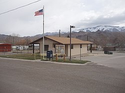
Marysvale Utah PO.jpeg
Marysvale post office
Piute County Utah incorporated and unincorporated areas Marysvale highlighted.svg
Location in Piute County and the state of Utah.
Coordinates: 38°26′51″N112°13′58″W / 38.44750°N 112.23278°W / 38.44750; -112.23278 Coordinates: 38°26′51″N112°13′58″W / 38.44750°N 112.23278°W / 38.44750; -112.23278
Country United States
State Utah
County Piute
Settled1863
Incorporated 1913
Area
[1]
  Total17.99 sq mi (46.60 km2)
  Land17.98 sq mi (46.57 km2)
  Water0.01 sq mi (0.03 km2)
Elevation
5,863 ft (1,787 m)
Population
 (2010)
  Total408
  Estimate 
(2019) [2]
437
  Density24.31/sq mi (9.38/km2)
Time zone UTC-7 (Mountain (MST))
  Summer (DST) UTC-6 (MDT)
ZIP code
84750
Area code 435
FIPS code 49-48610 [3]
GNIS feature ID1443220 [4]

Marysvale is a town in Piute County, Utah, United States. The population was 408 at the 2010 census. Marysvale is a trail head for the Paiute ATV Trail.

Contents

History

A post office called Marysvale has been in operation since 1872. [5] The town's name probably commemorates the Virgin Mary. [6]

In the late 1860s, silver ore was discovered in the Volcanic Series of Bullion Canyon and Mount Belknap, west of Marysvale in the Tushar Mountains. In 1889, gold was discovered. Then in 1949, uranium was discovered, prompting the United States Atomic Energy Commission to establish an ore purchasing station and field office in Marysvale. The uranium occurs as veins within quartz monzonite, granite and rhyolite, usually in the form of pitchblende, but also as umohoite, which was first identified at Marysvale. The pitchblende has been age dated to the Late Miocene. Total uranium production from the Marysvale area amounted to about 275,000 tons of 0.2 per cent U2O8. [7]

Geography

According to the United States Census Bureau, the town has a total area of 15.1 square miles (39.1 km2), of which 15.1 square miles (39.1 km2) is land and 0.07% is water.

Climate

The Köppen Climate Classification subtype for this climate is "BSk" (cold semi-arid climate).

Climate data for Marysvale, Utah (1991–2020 normals, extremes 1913–1918 and 1954–present)
MonthJanFebMarAprMayJunJulAugSepOctNovDecYear
Record high °F (°C)65
(18)
73
(23)
81
(27)
86
(30)
98
(37)
99
(37)
102
(39)
102
(39)
99
(37)
88
(31)
76
(24)
66
(19)
102
(39)
Average high °F (°C)42.8
(6.0)
47.5
(8.6)
56.5
(13.6)
63.4
(17.4)
73.0
(22.8)
84.1
(28.9)
89.6
(32.0)
87.4
(30.8)
79.9
(26.6)
66.9
(19.4)
53.6
(12.0)
42.0
(5.6)
65.6
(18.7)
Daily mean °F (°C)29.4
(−1.4)
33.9
(1.1)
41.4
(5.2)
47.5
(8.6)
55.6
(13.1)
64.9
(18.3)
70.9
(21.6)
68.9
(20.5)
60.9
(16.1)
49.2
(9.6)
38.4
(3.6)
28.8
(−1.8)
49.2
(9.6)
Average low °F (°C)15.9
(−8.9)
20.4
(−6.4)
26.2
(−3.2)
31.7
(−0.2)
38.3
(3.5)
45.7
(7.6)
52.1
(11.2)
50.5
(10.3)
41.9
(5.5)
31.6
(−0.2)
23.3
(−4.8)
15.7
(−9.1)
32.8
(0.4)
Record low °F (°C)−27
(−33)
−28
(−33)
−11
(−24)
7
(−14)
17
(−8)
23
(−5)
33
(1)
30
(−1)
20
(−7)
1
(−17)
−14
(−26)
−35
(−37)
−35
(−37)
Average precipitation inches (mm)0.66
(17)
0.59
(15)
0.68
(17)
0.59
(15)
0.78
(20)
0.37
(9.4)
0.86
(22)
0.91
(23)
0.84
(21)
0.86
(22)
0.59
(15)
0.47
(12)
8.20
(208)
Average precipitation days (≥ 0.01 in)4.86.25.55.84.62.75.66.95.44.93.74.260.3
Source: NOAA [8] [9]

Demographics

Historical population
CensusPop.Note
1880 297
1890 259−12.8%
1900 43568.0%
1910 49513.8%
1920 62426.1%
1930 471−24.5%
1940 62632.9%
1950 520−16.9%
1960 354−31.9%
1970 289−18.4%
1980 35924.2%
1990 3641.4%
2000 3814.7%
2010 4087.1%
2019 (est.)437 [2] 7.1%
U.S. Decennial Census [10]

At the 2000 census, there were 381 people, 149 households, and 113 families in the town. The population density was 25.2 people per square mile (9.7/km2). There were 222 housing units at an average density of 14.7 per square mile (5.7/km2). The racial makeup of the town was 98.43% White, 0.79% from other races, and 0.79% from two or more races. Hispanic or Latino of any race were 2.10%. [3]

Of the 149 households, 27.5% had children under the age of 18 living with them, 63.8% were married couples living together, 8.7% had a female householder with no husband present, and 23.5% were non-families. Of the 149 households, 8 are unmarried partner households: 2 heterosexual, 2 same-sex male, and 4 same-sex female. 21.5% of households were one person and 9.4% were one person aged 65 or older. The average household size was 2.56 and the average family size was 2.96.

The age distribution was 24.7% under the age of 18, 6.6% from 18 to 24, 20.2% from 25 to 44, 31.2% from 45 to 64, and 17.3% 65 or older. The median age was 44 years. For every 100 females, there were 96.4 males. For every 100 females age 18 and over, there were 91.3 males.

The median household income was $31,875 and the median family income was $35,417. Males had a median income of $33,125 versus $21,667 for females. The per capita income for the town was $12,715. About 9.1% of families and 11.8% of the population were below the poverty line, including 14.8% of those under age 18 and 2.9% of those age 65 or over.

Notable person

Actress Marie Windsor was born in Marysvale in 1919.

See also

Related Research Articles

<span class="mw-page-title-main">Piute County, Utah</span> County in Utah, United States

Piute County is a county in south-central Utah, United States. As of the 2010 United States Census, the population was 1,556, making it the second-least populous county in Utah. The county seat is Junction, and the largest town is Circleville.

<span class="mw-page-title-main">Masardis, Maine</span> Town in the state of Maine, United States

Masardis is a town in Aroostook County, Maine, United States. The population was 204 at the 2020 census.

Springfield is a town in Penobscot County, Maine, United States. The population was 293 at the 2020 census.

<span class="mw-page-title-main">Lewiston, Utah</span> City in Utah, United States

Lewiston is a city in Cache County, Utah, United States. It is situated at the northern Utah border and borders the state of Idaho. The population was 1,766 at the 2010 census. It is included in the Logan, Utah-Idaho (partial) Metropolitan Statistical Area.

<span class="mw-page-title-main">Tabiona, Utah</span> Town in the state of Utah, United States

Tabiona is a town in Duchesne County, Utah, United States. It is eighty-six miles southeast of the Salt Lake City metropolitan area. The population was 171 at the 2010 United States Census.

<span class="mw-page-title-main">Antimony, Utah</span> Town in the state of Utah, United States

Antimony is a town in Garfield County, Utah, United States. The population was 122 at the 2010 census, the same as the 2000 census.

<span class="mw-page-title-main">Henrieville, Utah</span> Town in the state of Utah, United States

Henrieville is a town in Garfield County, Utah, United States, along Utah Scenic Byway 12. As of the 2010 census, the town population was 230, up from 159 at the 2000 census.

<span class="mw-page-title-main">Kanarraville, Utah</span> Town in Utah, United States

Kanarraville is a town in Iron County, Utah, United States. The population was 355 at the 2010 census.

<span class="mw-page-title-main">Nephi, Utah</span> City in Utah, United States

Nephi is a city in Juab County, Utah, United States. It is part of the Provo–Orem metropolitan area. The population was 6,443 at the 2020 census. It is the county seat of Juab County. It was settled by Mormon pioneers in 1851 as Salt Creek, and it acquired its current name in 1882. It is the principal city in the Juab Valley, an agricultural area. Nephi was named after Nephi, son of Lehi, from the Book of Mormon.

<span class="mw-page-title-main">Scipio, Utah</span> Town in the state of Utah, United States

Scipio is a town on the eastern edge of Millard County, Utah, United States. The population was 290 at the 2000 census.

<span class="mw-page-title-main">Junction, Utah</span> Town in the state of Utah, United States

Junction is a town in and the county seat of Piute County, Utah, United States. The population was 191 at the 2010 census.

<span class="mw-page-title-main">Kingston, Utah</span> Town in Utah, United States

Kingston is a town in Piute County, Utah, United States. The population was 135 at the 2020 census.

<span class="mw-page-title-main">Bluff, Utah</span> Incorporated town and municipality in Utah, United States

Bluff is a town in San Juan County, Utah, United States. The population was 320 at the 2000 census. Bluff incorporated in 2018. Ann Leppanen is currently the mayor.

<span class="mw-page-title-main">Koosharem, Utah</span> Town in the state of Utah, United States

Koosharem is a town in Sevier County, Utah, United States. Koosharem is also known as "Grass Valley". It generally comprises the area known as Burrville, Utah on the north, south through the valley and through the town of Koosharem and down to the south end with the town of Greenwich, Utah. The valley is made up of private lands nestled within the Fishlake National Forest. Koosharem is situated at the cross-roads for travelers going between Capitol Reef National Park and Bryce Canyon National Park and/or Zion National Park. Koosharem is also the closest town to the famous Fish Lake. The town also serves as an important point along the many trails of the Piute ATV Trail System.

<span class="mw-page-title-main">Dugway, Utah</span> CDP in Utah, United States

Dugway is a census-designated place (CDP) in southeastern Tooele County, Utah, United States. The population was 2,016, at the 2000 census, a modest increase over the 1990 figure of 1,761. The town is located inside the United States Army's large weapons testing facility, Dugway Proving Ground, making it a closed city, as the only roads leading to the town pass through military checkpoints at the boundaries of the base. Non-resident civilians must request advance authorization to enter the town. The housing area designated for military and civilian personnel is referred to as "English Village."

<span class="mw-page-title-main">Rush Valley, Utah</span> Town in the state of Utah, United States

Rush Valley is a town in Tooele County, Utah, United States, located in the northwest of Rush Valley. It is part of the Salt Lake City, Utah Metropolitan Statistical Area. The population was 447 at the 2010 census, with an estimate population of 494 in 2019.

<span class="mw-page-title-main">Cedar Fort, Utah</span> Town in Utah, United States

Cedar Fort is a town in Utah County, Utah, United States. It is part of the Provo–Orem Metropolitan Statistical Area. The population was 368 at the 2010 census.

<span class="mw-page-title-main">Santaquin, Utah</span> City in Utah, United States

Santaquin is a city in Utah and Juab counties in the U.S. state of Utah. It is part of the Provo–Orem metropolitan area. The population was 13,725 at the 2020 census.

<span class="mw-page-title-main">New Harmony, Utah</span> Town in the state of Utah, United States

New Harmony is a town in northern Washington County, Utah, United States. The population was 207 at the 2010 census.

<span class="mw-page-title-main">Matoaka, West Virginia</span> Census-designated place in West Virginia, United States

Matoaka is a census-designated place in Mercer County, West Virginia, United States. The population was 227 at the 2010 census. It is part of the Bluefield, WV-VA micropolitan area which has a population of 107,578. This town is named for Chief Powhatan's daughter Matoaka who was better known by her nickname "Pocahontas". Matoaka became an unincorporated town when it voted to dissolve its charter in May 2018.

References

  1. "2019 U.S. Gazetteer Files". United States Census Bureau. Retrieved August 7, 2020.
  2. 1 2 "Population and Housing Unit Estimates". United States Census Bureau. May 24, 2020. Retrieved May 27, 2020.
  3. 1 2 "U.S. Census website". United States Census Bureau . Retrieved 2008-01-31.
  4. "US Board on Geographic Names". United States Geological Survey. 2007-10-25. Retrieved 2008-01-31.
  5. "Piute County". Jim Forte Postal History. Retrieved 18 October 2015.
  6. Van Atta, Dale (Jan 22, 1977). "You name it - there's a town for it". The Deseret News. pp. W6. Retrieved 18 October 2015.
  7. Kerr, Paul (1968). Ridge, John (ed.). The Marysvale Utah, Uranium Deposits, in Ore deposits of the United States, 1933-1967. New York: The American Institute of Mining, Metallurgical, and Petroleum engineers, Inc. pp. 1020–1042.
  8. "NOWData - NOAA Online Weather Data". National Oceanic and Atmospheric Administration. Retrieved November 25, 2022.
  9. "Summary of Monthly Normals 1991-2020". National Oceanic and Atmospheric Administration. Retrieved December 3, 2022.
  10. "Census of Population and Housing". Census.gov. Retrieved June 4, 2015.