1983 Borah Peak earthquake

Last updated
1983 Borah Peak earthquake
Borah1983.JPG
Borah Peak with fault scarp seen
near base of tan hill in foreground
USA Region West landcover location map.jpg
Blue pog.svg
Challis
City locator 1.svg
Boise
Bullseye1.png
USA Idaho location map.svg
Blue pog.svg
Challis
City locator 1.svg
Boise
Bullseye1.png
UTC  time1983-10-28 14:06:09
ISC  event 567352
USGS-ANSS ComCat
Local dateOctober 28, 1983 (1983-10-28)
Local time08:06 MDT [1]
Magnitude6.9 Mw [1]
Depth16 km (9.9 mi) [2]
Epicenter 44°05′N113°48′W / 44.08°N 113.8°W / 44.08; -113.8 [2]
FaultLost River Fault [3]
Type Normal [3]
Areas affected Central Idaho
United States
Total damage $12.5 million [4]
Max. intensity IX (Violent) [4]
LandslidesYes
Aftershocks5.6 Mw Oct 28 at 19:51 UTC [2]
5.5 Mw Oct 29 at 23:29 UTC [2]
Casualties2 killed, three injured [2]

The 1983 Borah Peak earthquake occurred on October 28, at 8:06:09 a.m. MDT in the western United States, in the Lost River Range at Borah Peak in central Idaho. [5] [6] [7]

Contents

The shock measured 6.9 on the moment magnitude scale and had a maximum Mercalli intensity of IX (Violent). It was the most violent earthquake in the lower 48 states in over 24 years, since the 1959 Hebgen Lake earthquake in nearby southwestern Montana. [8]

Earthquake

The Friday morning earthquake was caused by a slip on the preexisting Lost River Fault. [9] The event is the largest and most significant to strike in the state of Idaho. As a result of extreme surface faulting, a maximum Mercalli intensity of IX (Violent) was decided upon, while vibrational damage was at a Mercalli intensity of VI (Strong) to VII (Very strong). [4] Three weeks later on November 18, President Ronald Reagan declared the earthquake a major disaster. [10] [11]

Aftershocks were felt for a year afterwards; [12] nearly ten months later, a 5.4 aftershock was recorded on August 22, 1984. [11] [13] [14]

Surface faulting

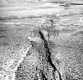
The rupture caused clear surface faulting; a 21-mile (34 km) long northwest-trending zone of fresh scarps and ground ruptures was present on a slope of the Lost River Range. Extensive breakage occurred along a five-mile (8 km) zone between West Spring and Cedar Creek; ground surface was literally "shattered" into tilted blocks, each several meters in width. These scarps were as broad as 330 feet (100 m). [4]

The ground breakage was sixty miles (100 km), and the throw on the faulting ranged from −1.6 to 8.9 feet (−0.5 to 2.7 m). [15]

Damage

The Challis-Mackay region experienced rather thorough damage, with eleven commercial buildings and 39 homes sustaining major damage while another 200 houses suffered minor to moderate damage. Mackay in particular, about fifty miles (80 km) southeast of Challis, experienced the most severe damage. Most of the city's large buildings on its Main Street were damaged, to some extent; [16] eight of these buildings were deemed condemned and closed down. Most of these buildings were built from materials such as brick, concrete block, and stone, each varying. [4]

An estimated $12.5 million in property damage was recorded. In some places, the water grounds shifted. [11]

Fatalities and injuries

In Challis, two children were killed when a stone storefront collapsed on them while walking to school; two others suffered minor injuries. In Mackay, a woman was hospitalized due to her injuries. [17]

Old Faithful

After the earthquake and aftershocks, the eruption intervals of Old Faithful geyser in Yellowstone National Park, about 150 miles (240 km) east, were noticeably lengthened. [18]

Sand blows

Near Chilly Buttes of Thousand Springs Valley, a series of artesian fountains/sand blows erupted immediately after the main shock. Groundwater gushed from these fountains forming small craters and depositing aprons of light-colored sandy sediment around each crater. The blows were noted largely along waterways, especially where draws, or small streams, enter into larger ones. Observers noted that some blows had black, sediment-laden water while others ran mostly clear. Some blows continued for several minutes after the shaking stopped. The Big Lost River rose several inches as a result of this water being expelled from the ground. The eruptions were likely a response to liquefaction of a water-laden underground sediment layer. [19]

See also

Related Research Articles

<span class="mw-page-title-main">Challis, Idaho</span> City in Idaho, United States

Challis is the largest city in Custer County, Idaho, United States. It is the county seat and its population was 1,081 at the 2010 census. The 2020 census shows 902 residents, a 16.6% drop.

<span class="mw-page-title-main">Borah Peak</span> Highest mountain in Idaho, United States

Borah Peak, also known as Mount Borah or Beauty Peak, is the highest mountain in the U.S. state of Idaho and one of the most prominent peaks in the contiguous United States. It is located in the central section of the Lost River Range, within the Challis National Forest in eastern Custer County. On February 11, 2021, the USGS officially recognized Mt. Borah as Idaho's only active glacier.

<span class="mw-page-title-main">1987 Whittier Narrows earthquake</span> Earthquake in southern California

The 1987 Whittier Narrows earthquake occurred in the southern San Gabriel Valley and surrounding communities of Southern California, United States, at 7:42 a.m. PDT on October 1. The moderate magnitude 5.9 blind thrust earthquake was centered several miles north of Whittier in the town of Rosemead, had a relatively shallow depth, and was felt throughout southern California and southern Nevada. Many homes and businesses were affected, along with roadway disruptions, mainly in Los Angeles and Orange counties. Damage estimates ranged from $213–358 million, with 200 injuries, three directly-related deaths, and five additional fatalities that were associated with the event.

<span class="mw-page-title-main">1993 Scotts Mills earthquake</span> Earthquake in Oregon

The 1993 Scotts Mills earthquake, also known as the "Spring break quake", occurred in the U.S. state of Oregon on March 25 at 5:34 AM Pacific Standard Time. With a moment magnitude of 5.6 and a maximum perceived intensity of VII on the Mercalli intensity scale, it was the largest earthquake in the Pacific Northwest since the Elk Lake and Goat Rocks earthquakes of 1981. Ground motion was widely felt in Oregon's Willamette Valley, the Portland metropolitan area, and as far north as the Puget Sound area near Seattle, Washington.

The 1952 Kern County earthquake occurred on July 21 in the southern San Joaquin Valley and measured 7.3 on the moment magnitude scale. The main shock occurred at 4:52 am Pacific Daylight Time, killed 12 people, injured hundreds more and caused an estimated $60 million in property damage. A small sector of damage near Bealville corresponded to a maximum Mercalli intensity of XI (Extreme), though this intensity rating was not representative of the majority of damage. The earthquake occurred on the White Wolf Fault near the community of Wheeler Ridge and was the strongest to occur in California since the 1906 San Francisco earthquake.

<span class="mw-page-title-main">1983 Coalinga earthquake</span> Earthquake affecting Central California

The 1983 Coalinga earthquake struck at 4:42 p.m. Monday, May 2 of that year, in Coalinga, California.

<span class="mw-page-title-main">1915 Pleasant Valley earthquake</span>

The 1915 Pleasant Valley earthquake occurred at 22:53:21 on October 2 in north-central Nevada. With a moment magnitude of 6.8, a surface wave magnitude of 7.7, and a maximum Mercalli intensity of X (Extreme), it was the strongest earthquake ever recorded in the state.

<span class="mw-page-title-main">Puente Hills Fault</span> Geological fault in California, United States

The Puente Hills Fault is an active geological fault that is located in the Los Angeles Basin in California. The thrust fault was discovered in 1999 and runs about 40 km (25 mi) in three discrete sections from the Puente Hills region in the southeast to just south of Griffith Park in the northwest. The fault is known as a blind thrust fault, as the fault plane does not extend to the surface. Large earthquakes on the fault are relatively infrequent but computer modeling has indicated that a major event could have substantial impact in the Los Angeles area. The fault is now thought to be responsible for one moderate earthquake in 1987 and another light event that took place in 2010, with the former causing considerable damage and deaths.

<span class="mw-page-title-main">1931 Valentine earthquake</span> Most powerful earthquake in Texas history

In the early morning hours of August 16, 1931, a powerful earthquake occurred in West Texas with a maximum Mercalli intensity of VIII (Severe). Estimates of its magnitude range between 5.8–6.4 mb, making it the most powerful earthquake ever recorded in Texas history. Its epicenter was near the town of Valentine, Texas; there, the earthquake caused damage to many homes and buildings. The earthquake may have been caused by movement along oblique-slip faulting in West Texas, the most seismically-active region in the state. Shaking from the earthquake was perceptible within a 400 mi (640 km) radius of the epicenter, affecting four U.S. states and northern Mexico. Several foreshocks and aftershocks accompanied the primary temblor, with the aftershocks continuing until at least November 3, 1931. The main earthquake caused no fatalities, though several people sustained minor injuries; the damage in Valentine amounted to $50,000–$75,000.

The 1986 Chalfant Valley earthquake struck southern Mono County near Bishop and Chalfant, California at 07:42:28 Pacific Daylight Time on July 21. With a moment magnitude of 6.2 and a maximum Mercalli intensity of VI (Strong), the shock injured two people and caused property damage estimated at $2.7 million in the affected areas. There was a significant foreshock and aftershock sequence that included a few moderate events, and was the last in a series of three earthquakes that affected southern California and the northern Owens Valley in July 1986.

The 1985 Rapel Lake earthquake occurred on 8 April at 21:56:59 local time with a moment magnitude of 7.2 and a maximum perceived intensity of VI (Strong). The shock was centered 75 kilometres (47 mi) southwest of Santiago, Chile, with a focal depth of 37.8 km (23 mi).

The 1872 North Cascades earthquake occurred at 9:40 p.m. local time on December 14 in central Washington Territory. A maximum Mercalli intensity of VIII (Severe) was assessed for several locations, though less intense shaking was observed at many other locations in Washington, Oregon, and British Columbia. Some of these intermediate outlying areas reported V (Moderate) to VII shaking, but intensities as high as IV (Light) were reported as far distant as Idaho and Montana. Due to the remote location of the mainshock and a series of strong aftershocks, damage to structures was limited to a few cabins close to the areas of the highest intensity.

The 1979 Imperial Valley earthquake occurred at 16:16 Pacific Daylight Time on 15 October just south of the Mexico–United States border. It affected Imperial Valley in Southern California and Mexicali Valley in northern Baja California. The earthquake had a relatively shallow hypocenter and caused property damage in the United States estimated at US$30 million. The irrigation systems in the Imperial Valley were badly affected, but no deaths occurred. It was the largest earthquake to occur in the contiguous United States since the 1971 San Fernando earthquake eight years earlier.

The 1954 Chlef earthquake struck Chlef Province in French Algeria on September 9 at 02:04:43 local time. The shock measured 6.7 on the moment magnitude scale and had a maximum Mercalli intensity of XI (Extreme). It destroyed Chlef, then named Orléansville, leaving over 1,243 people dead and 5,000 injured. Damage was estimated at $6 million. It was followed by multiple aftershocks. Algeria faces annual earthquakes and has undergone several changes to its earthquake building codes since its first earthquake engineering regulations from 1717.

The 1986 North Palm Springs earthquake occurred on July 8 at 02:20:44 local time with a moment magnitude of 6.0 and a maximum Mercalli Intensity of VII. The shock occurred in a complex setting along the San Andreas Fault Zone where it bisects San Gorgonio Mountain and San Jacinto Peak at the San Gorgonio Pass and was the first in a series of three earthquakes that affected southern California and the northern Owens Valley in July 1986. Numerous strong motion instruments recorded the event, one of which showed relatively high accelerations. Between 29 and 40 people were injured, and financial losses were estimated to be in the range of $4.5–6 million.

<span class="mw-page-title-main">2018 Hawaii earthquake</span> 6.9-magnitude earthquake in Hawaii

On May 4, 2018, an earthquake with a magnitude of Mw 6.9 struck Hawaii island in the Hawaii archipelago at around 12:33 p.m. local time. The earthquake's epicenter was near the south flank of Kīlauea, which has been the site of seismic and volcanic activity since late April of that year. According to the United States Geological Survey the quake was related to the new lava outbreaks at the volcano, and it resulted in the Hilina Slump moving about two feet. It was the largest earthquake to affect Hawaii since the 1975 earthquake, which affected the same region, killing two people and injuring another 28.

The 2020 Central Idaho earthquake occurred in the western United States on March 31, 2020, at 5:52 PM MDT, near Ruffneck Peak in the Sawtooth Mountains of central Idaho, 72 miles (116 km) northeast of Boise and 19 miles (31 km) northwest of Stanley. It had a magnitude of 6.5 and was felt with a maximum intensity of VIII.

In 1954, the state of Nevada was struck by a series of earthquakes that began with three magnitude 6.0+ events in July and August that preceded the Mw  7.1–7.3 mainshock and M 6.9 aftershock, both on December 12. All five earthquakes are among the largest in the state, and the largest since the Cedar Mountain earthquake of 1932 and Pleasant Valley event in 1915. The earthquake was felt throughout much of the western United States.

The 2021 Assam earthquake struck 11 km away from Dhekiajuli, Assam, India at 07:51 (IST) on April 28, 2021 with a moment magnitude of 6.0 at 34.0 km (21.1 mi) depth. The quake struck with an epicenter 140 km north of the main city of Guwahati. It resulted in two fatalities and at least 12 injuries.

On 9 July 2019, at 8:36 PM (PST), an earthquake measuring Mw 5.6 jolted the province of North Cotabato, Davao del Sur, and other nearby provinces. The National Disaster Risk Reduction and Management Council reported one dead and three injured in Makilala after the earthquake, and a total of 164 families affected in Cotabato Province. Near the epicenter of the earthquake, the severity of strong ground motion was assigned VI (Strong) on the Modified Mercalli intensity scale. A total of 106 schools, 119 houses, and 14 other infrastructures were damaged by the earthquake.

References

  1. 1 2 ISC (2015), ISC-GEM Global Instrumental Earthquake Catalogue (1900–2009), Version 2.0, International Seismological Centre
  2. 1 2 3 4 5 USGS (September 4, 2009), PAGER-CAT Earthquake Catalog, Version 2008_06.1, United States Geological Survey, archived from the original on 2020-03-13
  3. 1 2 Yeats, R. S.; Sieh, K. E.; Allen, C. R. (1997). The Geology of Earthquakes. Oxford University Press. p. 476. ISBN   978-0-19-507827-5.
  4. 1 2 3 4 5 Stover, C. W.; Coffman, J. L. (1993), Seismicity of the United States, 1568–1989 (Revised) – U.S. Geological Survey Professional Paper 1527 (PDF), United States Government Printing Office, pp. 216–221
  5. "Idaho quake measures 6.9, two killed". Spokane Chronicle. (Washington). wire reports. October 28, 1983. p. 1.
  6. "Quake jolts 8 states, kills 2 children". Eugene Register-Guard. (Oregon). (Los Angeles Times). October 29, 1983. p. 1A.
  7. Sher, Tom (October 29, 1983). "Killer quake rocks Northwest". Spokesman-Review. (Spokane, Washington). p. 1.
  8. AP (29 October 1983). "TWO CHILDREN DIE AS QUAKE HITS NORTHWEST AND CANADA". The New York Times. Retrieved 2018-11-12.
  9. "Observatory Seismology". publishing.cdlib.org. Retrieved 2018-11-12.
  10. "Quake disaster area declared in Idaho". Lewiston Morning Tribune. (Idaho). Associated Press. November 19, 1983. p. 3C.
  11. 1 2 3 "Idaho Earthquake History". ioem.idaho.gov. Archived from the original on 2018-11-13. Retrieved 2018-11-12.
  12. "4.5 aftershock quietly shakes Challis-Mackay". Deseret News. (Salt Lake City, Utah). January 25, 1984. p. 16B.
  13. "Idaho quake jolts, but not like 1983's". Deseret News. (Salt Lake City, Utah). UPI. August 23, 1984. p. B19.
  14. "Earthquake jolts Idaho". Spokesman-Review. (Spokane, Washington). wire services. August 23, 1984. p. 27.
  15. "Historical Earthquakes in Idaho | Idaho Geological Survey". www.idahogeology.org. Archived from the original on 2018-11-13. Retrieved 2018-11-12.
  16. Warchol, Glen; DelPorto, Brett (October 29, 1983). "Idaho quake cuts a swath of death and destruction". Deseret News. (Salt Lake City, Utah). p. A1.
  17. Shaughnessy, Rick (October 29, 1983). "Quake rocks mountain states; Strong shock kills 2 children". The Times-News . p. A1. Retrieved March 31, 2020 via Newspapers.com.
  18. Reid, T.R. (October 7, 1984). "Idaho quake upsets, yet befriends Old Faithful geyser". Lewiston Morning Tribune. (Idaho). (Washington Post). p. 5E.
  19. Youd, T. Leslie (November 1985). "The Borah Peak, Idaho earthquake of Oct. 28, 1983". Earthquake Spectra. doi:10.1193/1.1585303. S2CID   131701702 . Retrieved November 21, 2022.

Further reading