List of earthquakes
| Date | State(s) | Magnitude | Fatalities | Article | Further information |
|---|---|---|---|---|---|
| June 11, 1585 | Aleutian Islands, Alaska | 9.2 Mw | Unknown | 1585 Aleutian Islands earthquake | |
| January 26, 1700 | Washington, Oregon, California | 8.7–9.2 Mw | Unknown | 1700 Cascadia earthquake | |
| November 18, 1755 | Massachusetts | 5.9 Mw | 0 | 1755 Cape Ann earthquake | |
| July 21, 1788 | Alaska | 8.0 Ms | Unknown | [1] | |
| August 6, 1788 | Alaska | 8.0 Ms | Unknown | [1] | |
| December 16, 1811 | Missouri | 7.5–8.0 Mw | 100−500 | 1811–1812 New Madrid earthquakes | |
| December 8, 1812 | California | 6.9 Mla , 7.5 Mw | 40+ | 1812 San Juan Capistrano earthquake | |
| December 12, 1812 | California | 7.1–7.5 Mw | 1 | 1812 Ventura earthquake | |
| June 2, 1823 | Hawaii | 7.0 ML | 0 | [2] | |
| June 1838 | California | 6.8–7.2 Mw | 0 | 1838 San Andreas earthquake | |
| January 5, 1843 | Arkansas | 6.3 Mw | 0 | [2] | |
| January 9, 1857 | California | 7.9 Mw | 2 | 1857 Fort Tejon earthquake | |
| April 24, 1867 | Kansas | 5.1 Mfa | 0 | 1867 Manhattan, Kansas earthquake | |
| April 2, 1868 | Hawaii | 7.9 Mfa | 77 | 1868 Hawaii earthquake | |
| October 21, 1868 | California | 6.3–6.7 ML | 30 | 1868 Hayward earthquake | |
| February 20, 1871 | Hawaii | 6.8 ML | 0 | 1871 Lānaʻi earthquake [2] | |
| March 26, 1872 | California | 7.4–7.9 Mw | 27 | 1872 Owens Valley earthquake [3] | |
| December 14, 1872 | Washington | 6.5–7.0 Mw | 0 | 1872 North Cascades earthquake | |
| November 23, 1873 | California-Oregon | 7.3 ML | 0 | 1873 Oregon-California earthquake [2] | |
| October 26, 1880 | Alaska | 7.0 Ms | 0 | [1] | |
| November 8, 1882 | Colorado | 6.6 Mw | 0 | 1882 Fort Collins earthquake [4] | |
| August 10, 1884 | New York | 4.9–5.5 Mfa | 2 | ||
| August 31, 1886 | South Carolina | 6.9–7.3 Mw | 60 | 1886 Charleston earthquake | |
| April 19, 1892 | California | 6.4 ML | 1 | 1892 Vacaville–Winters earthquakes [2] | |
| April 21, 1892 | California | 6.4 ML | 0 | 1892 Vacaville–Winters earthquakes [2] | |
| October 31, 1895 | Missouri | 6.6 ML | 0 | 1895 Charleston earthquake [2] | |
| September 4, 1899 | Alaska | 8.2 Ms | 0 | 1899 Yakutat Bay earthquakes [1] | |
| September 10, 1899 | Alaska | 8.2 Mw | 0 | 1899 Yakutat Bay earthquakes [1] | |
| December 25, 1899 | California | 6.4 Ms | 6 | 1899 San Jacinto earthquake [1] | |
| October 9, 1900 | Alaska | 7.9 Mw | 0 | [5] | |
| November 14, 1901 | Utah | 7.0 Mw | 0 | 1901 Richfield earthquake | |
| December 31, 1901 | Alaska | 7.8 Ms | 0 | [1] | |
| January 1, 1902 | Alaska | 7.8 M | 0 | [1] | |
| August 27, 1904 | Alaska | 7.3 Ms | 0 | [2] | |
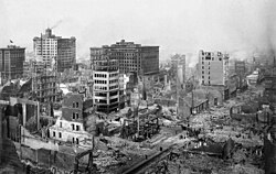
| April 18, 1906 | California | 7.9 Mw | 3,000+ | 1906 San Francisco earthquake | |
| August 17, 1906 | Alaska | 8.4 Mw | 0 | 1906 Aleutian Islands earthquake | |
| September 27, 1909 | Indiana | 5.1 Mfa | 0 | 1909 Wabash River earthquake | |
| June 23, 1915 | California | 6.2 M | 6 | 1915 Imperial Valley earthquakes | |
| October 3, 1915 | Nevada | 6.8 Mw | 0 | 1915 Pleasant Valley earthquake | |
| April 21, 1918 | California | 6.8 M | 0 | 1918 San Jacinto earthquake | |
| September 29, 1921 | Utah | 6.3 Mw | 0 | 1921 Sevier Valley earthquake | |
| January 31, 1922 | California | 7.6 MGR | 0 | [2] | |
| January 22, 1923 | California | 7.2 MGR | 0 | [2] | |
| June 28, 1925 | Montana | 6.6 Mw | 0 | 1925 Montana earthquake | |
| June 29, 1925 | California | 6.5–6.8 Mw | 13 | 1925 Santa Barbara earthquake | |
| October 24, 1927 | Alaska | 7.3 Mw | 0 | [6] | |
| November 4, 1927 | California | 7.3 Mw | 0 | 1927 Lompoc earthquake [1] | |
| March 7, 1929 | Alaska | 7.8 Mw | 0 | [7] | |
| August 16, 1931 | Texas | 6.5 Mw | 0 | 1931 Valentine earthquake | |
| December 21, 1932 | Nevada | 7.2 Mw | 0 | 1932 Cedar Mountain earthquake [2] | |
| March 10, 1933 | California | 6.4 Mw | 120 | 1933 Long Beach earthquake | |
| December 31, 1934 | California | 7.1 M | 0 | [1] | |
| March 12, 1934 | Utah | 6.6 Mw | 2 | 1934 Hansel Valley earthquake [8] | |
| October 18, 1935 | Montana | 6.2 Ms | 4 | 1935 Helena earthquake | |
| July 15, 1936 | Oregon, Washington | 5.8 ML | 0 | 1936 State Line earthquake | |
| July 22, 1937 | Alaska | 7.3 Ms | 0 | 1937 Alaska earthquake [2] | |
| November 10, 1938 | Alaska | 8.2 Mw | 0 | [9] | |
| May 18, 1940 | California | 6.9 Mw | 9 | 1940 El Centro earthquake | |
| December 20, 1940 | New Hampshire | 5.3 Mw | 0 | 1940 New Hampshire earthquakes | |
| December 24, 1940 | New Hampshire | 5.5 Mw | 0 | 1940 New Hampshire earthquakes | |
| November 3, 1943 | Alaska | 7.6 Mw | 0 | [10] | |
| September 5, 1944 | New York | 5.8 Mw | 0 | 1944 Cornwall–Massena earthquake | |
| April 1, 1946 | Alaska | 8.6 Mw | 165 | 1946 Aleutian Islands earthquake | |
| October 16, 1947 | Alaska | 7.2 Mw | 0 | [2] | |
| December 4, 1948 | California | 6.4 Mw | 0 | 1948 Desert Hot Springs earthquake | |
| April 13, 1949 | Washington | 6.7 Mw | 8 | 1949 Olympia earthquake | |
| July 21, 1952 | California | 7.3 Mw | 14 | 1952 Kern County earthquake | |
| July 6, 1954 | Nevada | 6.6 Mw | 0 | 1954 Rainbow Mountain earthquake [2] | |
| August 24, 1954 | Nevada | 6.8 Mw | 0 | 1954 Stillwater earthquake [2] | |
| December 16, 1954 | Nevada | 7.1 Mw | 0 | 1954 Fairview Peak earthquake [2] | |
| December 16, 1954 | Nevada | 6.8 Mw | 0 | 1954 Dixie Valley earthquake [2] | |
| March 9, 1957 | Alaska | 8.6 Mw | 0 | 1957 Andreanof Islands earthquake | |
| April 7, 1958 | Alaska | 7.3 Mw | 0 | 1958 Huslia earthquake [2] | |
| July 9, 1958 | Alaska | 7.8 Mw | 5 (tsunami) | 1958 Lituya Bay earthquake and megatsunami | |
| August 18, 1959 | Montana, Wyoming, Idaho | 7.2 Mw | 28+ | 1959 Hebgen Lake earthquake | |
| March 27, 1964 | Alaska | 9.2 Mw | 143 | 1964 Alaska earthquake | |
| February 4, 1965 | Alaska | 8.7 Mw | 0 | 1965 Rat Islands earthquake | |
| April 29, 1965 | Washington | 6.7 Mw | 7 | 1965 Puget Sound earthquake | |
| July 2, 1965 | Alaska | 7.8 Mw | 0 | [11] | |
| August 9, 1967 | Colorado | 5.3 | 0 | Rocky Mountain Arsenal#Deep injection well | |
| November 26, 1967 | Colorado | 5.2 | 0 | Rocky Mountain Arsenal#Deep injection well | |
| April 8, 1968 | California | 6.6 Mw | 0 | 1968 Borrego Mountain earthquake | |
| November 9, 1968 | Illinois | 5.4 mb | 0 | 1968 Illinois earthquake | |
| October 2, 1969 | California | 5.6, 5.7 ML | 1 | 1969 Santa Rosa earthquakes | Doublet |
| February 9, 1971 | California | 6.5–6.7 Mw | 58–65 | 1971 San Fernando earthquake | |
| July 30, 1972 | Alaska | 7.6 Mw | 0 | [12] | |
| February 2, 1975 | Alaska | 7.6 Ms | 0 | 1975 Near Islands earthquake | |
| November 29, 1975 | Hawaii | 7.7 Mw | 2 | 1975 Hawaii earthquake [13] | |
| November 8, 1980 | California | 7.2 Mw | 5 | 1980 Eureka earthquake [14] | |
| May 2, 1983 | California | 6.5 Mw | 0 | 1983 Coalinga earthquake | |
| November 16, 1983 | Hawaii | 6.7 Mw | 0 | 1983 Kaoiki earthquake [2] | |
| October 28, 1983 | Idaho | 7.3 Mw | 2 | 1983 Borah Peak earthquake | |
| April 24, 1984 | California | 6.2 Mw | 0 | 1984 Morgan Hill earthquake | |
| January 31, 1986 | Ohio | 5.0 Mw | 0 | 1986 Ohio earthquake | |
| May 7, 1986 | Alaska | 8.0 Mw | 0 | [15] [16] | |
| July 8, 1986 | California | 6.0 Mw | 0 | 1986 North Palm Springs earthquake | |
| July 21, 1986 | California | 6.4 ML | 0 | 1986 Chalfant Valley earthquake [17] | |
| October 1, 1987 | California | 5.9 Mw | 8 | 1987 Whittier Narrows earthquake | |
| November 23, 1987 | California | 6.2 Ms | 0 | 1987 Superstition Hills earthquakes [1] | |
| November 24, 1987 | California | 6.6 Mw | 2 | 1987 Superstition Hills earthquakes | |
| November 30, 1987 | Alaska | 7.9 Mw | 0 | [18] | |
| March 6, 1988 | Alaska | 7.8 Mw | 0 | [19] | |
| October 17, 1989 | California | 6.9 Mw | 63 | 1989 Loma Prieta earthquake | |
| September 4, 1989 | Alaska | 7.1 Mw | 0 | [20] | |
| May 30, 1991 | Alaska | 7.0 Mw | 0 | [21] | |
| June 28, 1991 | California | 5.6 Mw | 2 | 1991 Sierra Madre earthquake | |
| August 17, 1991 | Oregon | 7.0 Mh | 0 | [22] | |
| April 23, 1992 | California | 6.3 Ms | 0 | 1992 Joshua Tree earthquake [1] | |
| April 25–26, 1992 | California | 6.5–7.2 Mw | 0 | 1992 Cape Mendocino earthquakes | |
| June 28, 1992 | California | 7.3 Mw | 3 | 1992 Landers earthquake | |
| June 28, 1992 | California | 6.5 Mw | 0 | 1992 Big Bear earthquake | |
| September 2, 1992 | Utah | 5.8 ML | 0 | 1992 St. George earthquake [23] | |
| March 25, 1993 | Oregon | 5.6 Md | 0 | 1993 Scotts Mills earthquake | |
| September 20, 1993 | Oregon | 6.0 Md | 2 | 1993 Klamath Falls earthquakes | |
| January 17, 1994 | California | 6.7 Mw | 57 | 1994 Northridge earthquake | |
| September 1, 1994 | California | 7.0 Mw | 0 | 1994 Northern California earthquake [24] | |
| April 14, 1995 | Texas | 5.7 Mw | 0 | 1995 Marathon earthquake | |
| June 10, 1996 | Alaska | 7.9 Mwc | 0 | [25] | |
| September 25, 1998 | Pennsylvania | 5.2 mbLg | 0 | 1998 Pymatuning earthquake | |
| October 16, 1999 | California | 7.1 Mw | 0 | 1999 Hector Mine earthquake | |
| December 6, 1999 | Alaska | 7.0 Mw | 0 | [26] | |
| January 10, 2001 | Alaska | 7.0 Mw | 0 | [27] | |
| February 28, 2001 | Washington | 6.8 Md | 1 | 2001 Nisqually earthquake | |
| November 3, 2002 | Alaska | 7.9 Mw | 0 | 2002 Denali earthquake | |
| November 17, 2003 | Alaska | 7.8 Mwc | 0 | 2003 Alaska earthquake [28] | |
| December 22, 2003 | California | 6.5 Mw | 2 | 2003 San Simeon earthquake | |
| June 15, 2005 | California | 7.2 Mwc | 0 | [29] | |
| September 10, 2006 | Florida | 5.9 Mwc | 0 | 2006 Gulf of Mexico earthquake | |
| October 15, 2006 | Hawaii | 6.7 Md | 0 | 2006 Kiholo Bay earthquake | |
| October 30, 2007 | California | 5.5 Mw | 0 | 2007 Alum Rock earthquake | |
| February 21, 2008 | Nevada | 5.9 Mw | 0 | 2008 Wells earthquake | |
| April 18, 2008 | Illinois | 5.2 Mw | 0 | 2008 Illinois earthquake | |
| July 29, 2008 | California | 5.4 Mw | 0 | 2008 Chino Hills earthquake | |
| January 9, 2010 | California | 6.5 Mw | 0 | 2010 Eureka earthquake | |
| April 4, 2010 | California | 7.2 Mw | 0 | 2010 Baja California earthquake | |
| August 22, 2011 | Colorado | 5.3 Mwr | 0 | 2011 Colorado earthquake | |
| August 23, 2011 | Virginia | 5.8 Mw | 0 | 2011 Virginia earthquake | |
| November 5, 2011 | Oklahoma | 5.7 Mww | 0 | 2011 Oklahoma earthquake | |
| January 5, 2013 | Alaska | 7.5 Mw | 0 | 2013 Craig, Alaska earthquake [30] | |
| March 29, 2014 | California | 5.1 Mw | 0 | 2014 La Habra earthquake | |
| June 23, 2014 | Alaska | 7.9 Mww | 0 | 2014 Aleutian Islands earthquake | |
| July 25, 2014 | Alaska | 6.0 Mw | 0 | 2014 Palma Bay earthquake | |
| August 24, 2014 | California | 6.0 Mw | 1 | 2014 South Napa earthquake | |
| January 24, 2016 | Alaska | 7.1 Mw | 0 | 2016 Old Iliamna earthquake | |
| September 3, 2016 | Oklahoma | 5.8 Mww | 0 | 2016 Oklahoma earthquake | |
| January 23, 2018 | Alaska | 7.9 Mww | 0 | 2018 Gulf of Alaska earthquake | |
| May 4, 2018 | Hawaii | 6.9 Mww | 0 | 2018 Hawaii earthquake | |
| November 30, 2018 | Alaska | 7.1 Mww | 0 | 2018 Anchorage earthquake | |
| July 4, 2019 | California | 6.4 Mw | 1 | 2019 Ridgecrest earthquakes | |
| July 5, 2019 | California | 7.1 Mw | 0 | 2019 Ridgecrest earthquakes | |
| March 18, 2020 | Utah | 5.7 Mw | 0 | 2020 Salt Lake City earthquake | |
| March 31, 2020 | Idaho | 6.5 Mww | 0 | 2020 Central Idaho earthquake | |
| May 15, 2020 | Nevada | 6.5 ML | 0 | 2020 Monte Cristo Range earthquake [31] | |
| July 22, 2020 | Alaska | 7.8 Mw | 0 | 2020 Alaska Peninsula earthquake [32] | |
| August 9, 2020 | North Carolina | 5.1 Mw | 0 | 2020 Sparta earthquake [33] | |
| October 19, 2020 | Alaska | 7.6 Mww | 0 | 2021 Chignik earthquake § October 2020 [34] | |
| July 29, 2021 | Alaska | 8.2 Mw | 0 | 2021 Chignik earthquake [35] | |
| December 20, 2022 | California | 6.4 Mw | 2 | 2022 Ferndale earthquake [36] | |
| April 5, 2024 | New Jersey | 4.8 Mw | 0 | 2024 New Jersey earthquake [37] | |
| December 5, 2024 | California | 7.0 Mw | 0 | 2024 Cape Mendocino earthquake [38] |

Earthquake swarms which affected the United States:
- 1962–71 Denver earthquake swarm [39]
- Enola earthquake swarm
- 2008 Reno earthquakes
- Guy-Greenbrier earthquake swarm
- Oklahoma earthquake swarms (2009–present)
Earthquakes which affected the United States but whose epicenters were outside the United States borders:
- 1925 Charlevoix–Kamouraska earthquake – magnitude 6.2 earthquake, no injuries or fatalities anywhere
- 1979 Imperial Valley earthquake – magnitude 6.4 earthquake with an epicenter less than 1 km inside Mexico – significant damage and injuries on both sides of the border (60 in the US)
- 2010 Baja California earthquake (Mexico near S California) – magnitude 7.2 earthquake, 4 fatalities and 100 injuries, none in the United States
Earthquakes which did not affect the United States directly, but caused tsunamis which did:
- 1960 Valdivia earthquake and tsunami – magnitude 9.5 earthquake, between 2200 and 6000 fatalities, including 61 in Hilo, HI
- 2006 Kuril Islands earthquake and tsunami – magnitude 8.3 earthquake, no injuries or fatalities anywhere
- 2009 Samoa earthquake and tsunami – magnitude 8.0 earthquake with an epicenter 120 miles (190 km) southwest of American Samoa generated tsunami waves up to 16 feet (5 m), killing 34 people in American Samoa and causing extensive damage [40]
- 2010 Chile earthquake and tsunami – magnitude 8.8 earthquake, ~525 fatalities and unknown number of injuries, none in the United States
- 2011 Tohoku earthquake and tsunami – magnitude 9.0 earthquake, 15,850–28,000 fatalities and 6,011 injured, one fatality and unknown number of injuries in the United States
- 2012 Haida Gwaii earthquake – magnitude 7.8 earthquake with an epicenter on Moresby Island in British Columbia, the second-largest Canadian earthquake ever recorded by a seismometer. Over 100,000 people were evacuated to higher ground in the state of Hawai'i.