2010 Chile earthquake

Last updated

2010 Chile earthquake
2010 Chile earthquake - Building destroyed in Concepcion.jpg
Damage sustained by a building in Concepción, located around 100 kilometres south of the epicenter.
2010 Chile earthquake epicenter.png
UTC  time2010-02-27 06:34:12
ISC  event 14340585
USGS-ANSS ComCat
Local date27 February 2010 (2010-02-27) [1]
Local time03:34:12 CST (UTC-03:00)
Duration3 minutes
Magnitude8.8 Mww
Depth35 km (22 mi) [2]
30.1 km (19 mi) [1]
Epicenter 35°54′32″S72°43′59″W / 35.909°S 72.733°W / -35.909; -72.733 [2]
36°17′24″S73°14′20″W / 36.290°S 73.239°W / -36.290; -73.239 [1]
Type Megathrust
Areas affectedChile
Max. intensity IX (Violent) [1] [3]
Peak acceleration0.65 g [4]
Tsunami24.1 m (79 ft) [5]
Casualties525 dead, 25 missing [6]
The partially collapsed 21-story O'Higgins Tower, Concepcion Torre O'Higgins conce.jpg
The partially collapsed 21-story O'Higgins Tower, Concepción

The 2010 Chile earthquake and tsunami (Spanish : Terremoto del 27F) [7] occurred off the coast of central Chile on Saturday, 27 February at 03:34:12 local time (06:34:12 UTC), having a magnitude of 8.8 on the moment magnitude scale, with intense shaking lasting for about three minutes. [8] [1] [2] [9] It was felt strongly in six Chilean regions (from Valparaíso in the north to Araucanía in the south) that together make up about 80 percent of the country's population. According to the United States Geological Survey (USGS) the cities experiencing the strongest shaking—VIII (Severe) on the Mercalli intensity scale (MM)—were Concepción, Arauco, and Coronel. According to Chile's Seismological Service, Concepción experienced the strongest shaking at MM IX (Violent). [1] [3] The earthquake was felt in the capital Santiago at MM VII (Very strong) [10] or MM VIII. [1] Tremors were felt in many Argentine cities, including Buenos Aires, Córdoba, Mendoza, and La Rioja. [11] [12] Tremors were felt as far north as the city of Ica in southern Peru (approx. 2,400 km (1,500 mi) away). It is the largest earthquake to hit Chile since the 1960 Valdivia earthquake.

Contents

The earthquake triggered a tsunami which devastated several coastal towns in south-central Chile and damaged the port at Talcahuano. Tsunami warnings were issued in 53 countries, [13] and the wave caused minor damage in the San Diego area of California [14] and in the Tōhoku region of Japan, where damage to the fisheries business was estimated at ¥6.26 billion (US$66.7 million). [15] The earthquake also generated a blackout that affected 93 percent of the Chilean population and which went on for several days in some locations. [16] President Michelle Bachelet declared a "state of catastrophe" and sent military troops to take control of the most affected areas. According to official sources, 525 people lost their lives, 25 people went missing [6] and about 9% of the population in the affected regions lost their homes. [17]

On 10 March, Swiss Reinsurance Co. estimated that the Chilean quake would cost insurance companies between 4 and 7 billion dollars. The rival German-based Munich Re AG made the same estimate. [18] The losses to the economy of Chile caused by the earthquake are estimated at US$15–30 billion. [19]

Location/Epicenter

According to the USGS, the epicenter of the earthquake was about 3 km (1.9 miles) off the coast of Pelluhue, a town in the Maule Region. This is about 6 km (3.7 miles) west of the village of Chovellén, 15 km (9.3 miles) southwest of the town of Pelluhue and at a point approximately 100 km (62 miles) away from the following four provincial capitals: Talca (to the north-east), Linares (to the east), Chillán (to the south-east) and Concepción (to the south). [2] Chile's Seismological Service located the quake's epicenter at about 34 km (21 miles) off the coast of Ñuble Region in the Biobío Region. This is 60 km (37 miles) north of Concepción and 170 km (110 miles) south-west of Talca. [1]

Seismology and geology

The earthquake took place along the boundary between the Nazca and South American tectonic plates at a location where they converge at a rate of 80 millimetres (3.1 in) a year.[ citation needed ] This earthquake was characterized by a thrust-faulting focal mechanism, caused by the subduction of the Nazca plate beneath the South American Tectonic Plates. [2] The end-regions of the rupture zone coincided with the Andean oroclines of Maipo (33° S) and Arauco (37° S). This has been interpreted as suggesting a link between upper plate (South American plate) structure and rupture length. [20]

Chile has been at a convergent plate boundary that generates megathrust earthquakes since the Paleozoic era (500 million years ago). In historical times the Chilean coast has suffered many megathrust earthquakes along this plate boundary, including the strongest earthquake ever measured, the 1960 Valdivia earthquake. More recently, the boundary ruptured during the 2007 Tocopilla earthquake in northern Chile.[ citation needed ]

The segment of the fault zone which ruptured in this earthquake was estimated to be over 700 km (430 mi) long with a displacement of almost 10 meters, or 120 years of accumulated plate movement. [21] It lay immediately north of the 1,000 km (620 mi) segment which ruptured in the great earthquake of 1960. [22] Preliminary measurements show that the entire South American Plate moved abruptly westward during the quake. [23] A research collaborative of Ohio State and other institutions have found, using GPS, that the earthquake shifted Santiago 28 cm (11 in) to the west-southwest and moved Concepción at least 3 metres (10 ft) to the west. The earthquake also shifted other parts of South America from the Falkland Islands to Fortaleza, Brazil. For example, it moved Argentina's capital of Buenos Aires about 2.5 cm (0.98 in) to the west. [24] Several cities south of Cobquecura were also raised by up to 3 meters. [25] The maximum recorded peak ground acceleration was at Concepcion, with a value of 0.65 g (6.38 m/s2). [26]

The locality of Tirúa south of Concepción recorded a 180 cm (71 in) uplift relative to sea level as result of the earthquake. This is the highest known uplift of the coast resulting from the earthquake. [27] This uplift made a large islet emerge at the mouth of Lebu River. [27]

USGS shake map of the earthquake 2010 Maule earthquake intensity USGS.jpg
USGS shake map of the earthquake

Compared with past earthquakes

This was the strongest earthquake affecting Chile since the magnitude 9.5 1960 Valdivia earthquake (the most energetic earthquake ever measured), and it was the strongest earthquake worldwide since the 2004 Indian Ocean earthquake and until the 2011 Tōhoku earthquake. [28] It is tied with the 1906 Ecuador–Colombia and 1833 Sumatra earthquakes as the sixth strongest earthquake ever measured, approximately 500 times more powerful than the 7.0 Mw earthquake in Haiti one month prior in January 2010. [29]

Aftershocks

An aftershock of 6.2 was recorded 20 minutes after the initial quake. [30] [31] Two more aftershocks of magnitudes 5.4 and 5.6 followed within an hour of the initial quake. [31] The USGS said that "a large vigorous aftershock sequence can be expected from this earthquake". [2] By 6 March UTC, more than 130 aftershocks had been registered, including thirteen above magnitude 6.0. [32]

Shortly after the mainshock seismologists installed a dense network of seismometers along the whole rupture area. This network captured 20,000 aftershocks in the 6 months after the mainshock and shows a detailed picture of the structure of the Chilean margin. [33] Seismicity is focused in the depth range of 25–35 km (16–22 mi) and in a deeper band of between 45 and 50 km (28 and 31 mi) depth. Around 10,000 aftershocks occurred in the region of two large aftershocks in the Pichilemu region.[ citation needed ]

A 6.9-magnitude offshore earthquake struck approximately 300 kilometers southwest of, and less than 90 minutes after, the initial shock; however, it is not clear if that quake was related to the main shock. [34] A separate earthquake of magnitude 6.3 occurred in Salta, Argentina, at 15:45 UTC on 27 February, at a depth of 38.2 km (23.7 mi); [35] two people were injured and one died in Salta. [36] This earthquake was followed on 1 March at 06:32 UTC by a magnitude 4.9 aftershock. [37] Four other earthquakes above M5.0, some possible aftershocks, also occurred near the border in Argentina following the Chile earthquake; a magnitude 5.0 earthquake occurred in Mendoza on 28 February, a M5.3 earthquake in Neuquen and a M5.2 in San Juan on 2 March, and a M5.1 quake in Mendoza on 4 March. [38] [39] [40] [41]

Another strong earthquake occurred on 4 March, at 22:39 UTC in Antofagasta in northern Chile, with a magnitude of 6.3. [42]

Minor quakes generated by the main one could be felt as far away as São Paulo, Brazil, [43] located about 3,000 km (1,900 mi) away from Concepción. Since the major earthquake, and as of 15 March, at least four to forty >M5.0 earthquakes have been recorded daily in the vicinity of the main earthquake, [44] including four above magnitude 6.0 between 3 March and 6 March. [31]

On 5 March, two aftershocks above M6.0 were reported. The first was a 6.3-magnitude off the coast of the Biobío Region. The second was near the epicenter of the original quake at 08:47 local time with a magnitude of 6.6. [45]

On 11 March, the March 2010 Chile earthquake (magnitude 6.9, treated by some as an aftershock of the February 2010 earthquake) was reported, followed quickly by further aftershocks measuring 6.7 and 6.0. The epicenter of the 6.9 quake was in Pichilemu, O'Higgins Region. [46] [47]

On 15 March, two aftershocks of the February 2010 earthquake were reported, one at magnitude 6.2 at 08:08:28 local time offshore Maule, [48] and another at magnitude 6.7 with the epicenter located offshore the Biobío Region, near Cobquecura, at 23:21:58 local time. [49] This tremor was followed by two minor aftershocks, one occurring 45 minutes later, measuring M5.5. No tsunami was reported and there were no tsunami warnings issued.[ citation needed ]

On 17 March, at 14:38:37 local time, an earthquake of magnitude 5.2 was recorded in Aisén, in Southern Chile. [50] Another magnitude 5.2 earthquake was recorded in Los Lagos the next day. On 26 March, at 10:52:06 local time, a magnitude 6.2 earthquake hit the Atacama region, in Northern Chile. [51]

The Biobio Region of Chile had strong aftershocks of this earthquake. The first one was a magnitude 6.7 MW earthquake that struck off the coast of Biobío, Chile, at 23:21 on 15 March 2010 at the epicenter, at a depth of 18 kilometres (11 mi). The second earthquake struck on land in the region at 22:58 (UTC) on 2 April 2010 at 5.9 MW and at a depth of 39 km (24 mi). The third struck on 10:03 (UTC) on 23 April 2010 at 6.2 MW. [52] The Pacific Tsunami Warning Center said that historical data indicates that this quake would not generate a tsunami but still advised of the possibility. [53] On 3 May, at 19:09 a 6.4 MW earthquake magnitude struck off Biobío, Chile, at the epicenter, at a depth of 20 km (12 mi). The epicenter was 55 km (34 mi) south of Lebu. [54] On 14 July 2010, another 6.5 magnitude earthquake occurred in the area.[ citation needed ]

2011 aftershocks

On 2 January at 17:20:18 local time, a 7.1 magnitude aftershock occurred 70 km (43 mi) northwest of Temuco, Chile. [55] On Lautaro, Cañete, Nueva Imperial, Traiguén and Carahue the quake was felt at intensity VI (Strong) of the Mercalli intensity scale. In Temuco it was perceived at intensity V (Moderate). In Talcahuano, Concepción, Chillán, Osorno and Valdivia it shook at intensity IV (Light). [56] According to the USGS the earthquake's epicenter was located on the ground, east of the coastal town of Tirúa in the Araucanía Region. However, according to the University of Chile's Seismological Service, the seismic event was located 134 km (83 mi) off the coast of Tirúa, measuring a magnitude 6.9 ML. The University of Chile also reported that the localities who received the strongest shaking (VI) were Curanilahue, Lebu and Tirúa. In Concepción, Talcahuano and Temuco it was felt at intensity V, and in Chillán and Valdivia at intensity IV. [57]

A magnitude 6.2 Mw aftershock struck the coast of Biobío, Chile at a shallow depth of 15.1 km (9.4 mi) on 1 June 2011 at 08:55 local time (12:55  UTC). [58] It was centered just offshore Arauco Province near a moderately populated area, with most structures in its vicinity reported to be resistant to earthquake shaking. Strong shaking registering at VI on the Mercalli intensity scale was felt in Lebu, just 7 km (4.3 mi) south of the epicenter, lasting for approximately one minute. [59] [60] Some residents in coastal areas panicked and evacuated their homes. [61] The earthquake was followed by a moderate magnitude 5.1 Mw tremor that occurred about 52 minutes later to the northeast of the main shock epicenter at an estimated depth of 26.9 km (16.7 mi). [62] Initial estimates from the USGS placed its intensity at a magnitude of 6.4 Mw. [63]

Geophysical impact

Seismologists estimate that the earthquake was so powerful that it may have shortened the length of the day by 1.26 microseconds and moved the Earth's figure axis by 2.7 milliarcseconds (about 8 cm). [64] [65] Precise GPS measurement indicated the telluric movement moved the entire city of Concepción 3.04 metres (10.0 ft) to the west. The capital Santiago experienced a displacement of almost 24 centimetres (9.4 in) west, and even Buenos Aires, about 1,350 kilometres (840 mi) from Concepción, [66] shifted 4 centimetres (1.6 in). [67] [68] It is estimated that Chile's territory could have expanded 1.2 square kilometres (0.46 sq mi) as a result. [69]

The earthquake also caused seiches to occur in Lake Pontchartrain to the north of New Orleans, United States, located nearly 7,500 kilometres (4,700 mi) from the epicenter of the quake. [70] In Antarctica a series of icequakes were triggered by the 2010 earthquake in Chile. [71]

Damage and casualties

People were found dead after the earthquake struck, mostly under buildings and inside cars. Many people were also seriously injured. Most injuries were reported in Santiago and Maule.[ citation needed ]

According to an Associated Press Television News cameraman, some buildings collapsed in Santiago and there were power outages in parts of the city. [72] A fire was reported in a chemical plant on the outskirts of Santiago and caused the evacuation of the neighborhood. [30] Santiago's International Airport seemed to have been damaged and the airport authority closed off all flight operations for 24 hours from around 12:00 UTC. [8] On Sunday, 28 February, Ricardo Ortega, head of the Chilean Air Force, said commercial airline services had been partially re-established and aircraft were being allowed to land in Santiago. [73]

Santiago's national Fine Arts Museum was badly damaged and did not reopen until 9 March 2010. [74] An apartment building's two-story parking lot collapsed, wrecking 68 cars. According to one health official, three hospitals in Santiago collapsed, and a dozen more south of the capital also suffered significant damage. [75]

In Valparaíso, a tsunami wave of 1.29 m (4 ft 3 in) was reported. The port of Valparaíso was ordered to close due to the damage caused by the earthquake.[ citation needed ] The port started to resume limited operations on 28 February. [76] In Viña del Mar, a touristic city and part of Greater Valparaíso, several buildings were structurally damaged, principally in the district Plan de Viña. [77]

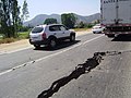
Many cities in the Maule region were seriously affected by the earthquake which triggered more than 1,000 landslides, a significant contributor to earthquake fatalities. Mapped from satellite images, most landslides occurring in the Principal Andean Cordillera and a constrained area on the Arauco Peninsula. Curanipe, only 8 km (5 mi) from the epicenter, was hit by a tsunami after the earthquake and still remained isolated from outside as of 28 February. [78] A surfer said the tsunami "...was like the one in Thailand, a sudden rise of water. One could not estimate the dimension of the wave, because it was advancing foam. There were 10 to 15 rises, the last one being at 08:30 in the morning." [79] In Talca, the capital of the Maule region, many dead were trapped in the rubble. The administrative building was uninhabitable, and the authorities had to be set up in the parade ground. [80] All but two of the local hospital's thirteen wings were in ruins. Dr. Claudio Martínez was quoted as saying, "We're only keeping the people in danger of dying." Hospital staff attempted to transport some patients to Santiago on Sunday morning, but roads were blocked. [81]

Damaged buildings and fires were reported in Concepción. [82] Rescue teams had difficulty accessing Concepción because of the damaged infrastructure. [30] The fifteen-story residential building "Alto Río" toppled, lay on the ground horizontally, and trapped many of the residents. As the building was newly completed, 19 of the apartments were occupied and 36 were of unknown occupancy. [83] [84] [85] A 2.34 m (7 ft 8 in) tsunami wave hit Talcahuano, a port city and part of the Concepción conurbation. The tsunami caused serious damage to port facilities and lifted boats out of the water. [86] In the fishing town of Dichato, of 7,000 residents, it was the third tsunami wave that ended up being the most damaging. [87]

Dilapidated buildings could be seen on the streets of Temuco, about 400 km (250 mi) from the epicenter. The adobe of some buildings fell. Façades fell in pieces and crushed cars. Two people were reported dead because of not having been able to escape from a nightclub. On 27 February, it was reported that "finding an open business [was] almost impossible" ("Encontrar un negocio abierto es casi imposible"). [88] [89] Further south, in the city of Valdivia damage to houses were restricted to areas of poor soil quality, chiefly former wetlands and artificial fills. [90] Some pavements near the rivershore in Valdivia cracked and collapsed much like in the 1960 earthquake. [90] Overall there was little damage in Valdivia and this was highly localized. [90] A survey showed that 434 persons in Valdivia had their homes damaged by the earthquake. [90]

The earthquake also triggered more than 1,000 landslides mapped from satellite images [91] with most landslides occurring in the Principal Andean Cordillera and a constrained area on the Arauco Peninsula [91] [92] Landslides are a significant contributor to earthquake fatalities. In Chile, 370,000 homes were damaged. [93] The final death toll of 525 victims and 25 people missing was announced by authorities in January 2011. [6] This is down from early reports on 3 March of 802 people dead. [94]

The Chilean National Emergency Office ( Oficina Nacional de Emergencia ) estimated that the intensity of the earthquake was 9 on the Mercalli intensity scale in the Biobío Region and 8 in Santiago. [30] [95] USGS put the intensity in Talcahuano at MM VIII, in Santiago and Concepción at MM VII and in Valparaíso at MM VI. [10]

On 10 March, Swiss Reinsurance Co. estimated that the Chilean quake would cost the insurance industry between 4 and 7 billion dollars. The same estimate was echoed by the rival German-based Munich Re AG. [18]

Modified Mercalli intensities for some localities

LocalityCountryUSGS [96] SS [1] Population [96]
Angol Flag of Chile.svg ChileVII45k
Antofagasta Flag of Chile.svg ChileII
Arauco Flag of Chile.svg ChileVIII25k
Buín Flag of Chile.svg ChileVII55k
Bulnes Flag of Chile.svg ChileVII13k
Cabrero Flag of Chile.svg ChileVIII18k
Calama Flag of Chile.svg ChileII
Cañete Flag of Chile.svg ChileVIII20k
Carahue Flag of Chile.svg ChileVI12k
Cauquenes Flag of Chile.svg ChileVIII31k
Chiguayante Flag of Chile.svg ChileVII83k
Chillán Flag of Chile.svg ChileVII150k
Chimbarongo Flag of Chile.svg ChileVII17k
Coihueco Flag of Chile.svg ChileVII7k
Collipulli Flag of Chile.svg ChileVII16k
Concepción Flag of Chile.svg ChileVIIIIX215k
Constitución Flag of Chile.svg ChileVIII38k
Copiapó Flag of Chile.svg ChileIII
Coquimbo Flag of Chile.svg ChileV
Coronel Flag of Chile.svg ChileVIII93k
Corral Flag of Chile.svg ChileV4k
Curanilahue Flag of Chile.svg ChileVIII31k
Curicó Flag of Chile.svg ChileVII102k
Cutral-Co Flag of Argentina.svg ArgentinaV47k
El Monte Flag of Chile.svg ChileVIII23k
Freire Flag of Chile.svg ChileVII8k
General Roca Flag of Argentina.svg ArgentinaIV73k
Graneros Flag of Chile.svg ChileVII23k
La Calera Flag of Chile.svg ChileVII49k
Huayco Flag of Chile.svg ChileIII
Illapel Flag of Chile.svg ChileVI23k
Laja Flag of Chile.svg ChileVII17k
La Ligua Flag of Chile.svg ChileVII25k
La Unión Flag of Chile.svg ChileVI26k
Lampa Flag of Chile.svg ChileVI29k
Las ÁnimasVI30k
Las GaviotasFlag of Argentina.svg ArgentinaV2k
Lautaro Flag of Chile.svg ChileVII22k
Lebu Flag of Chile.svg ChileVII22k
Limache Flag of Chile.svg ChileVII36k
Linares Flag of Chile.svg ChileVII70k
Llaillay Flag of Chile.svg ChileVI17k
Loncoche Flag of Chile.svg ChileVI16k
Longaví Flag of Chile.svg ChileVII6k
Los Andes Flag of Chile.svg ChileVII57k
Los Ángeles Flag of Chile.svg ChileVII125k
Lota Flag of Chile.svg ChileVII50k
Machali Flag of Chile.svg ChileVII28k
Melipilla Flag of Chile.svg ChileVII63k
Mendoza Flag of Argentina.svg ArgentinaV877k
Molina Flag of Chile.svg ChileVII29k
Mulchén Flag of Chile.svg ChileVII22k
Nacimiento Flag of Chile.svg ChileVII21k
Neuquén Flag of Argentina.svg ArgentinaIV242k
Nueva Imperial Flag of Chile.svg ChileVI19k
Osorno Flag of Chile.svg ChileVI136k
Paine Flag of Chile.svg ChileVII33k
Panguipulli Flag of Chile.svg ChileVI16k
Parral Flag of Chile.svg ChileVIII27k
Peñaflor Flag of Chile.svg ChileVII66k
Penco Flag of Chile.svg ChileVII46k
Pitrufquen Flag of Chile.svg ChileVI14k
Puerto Montt Flag of Chile.svg ChileV
Quillota Flag of Chile.svg ChileVII68k
Quilpué Flag of Chile.svg ChileVII130k
Rancagua Flag of Chile.svg ChileVIIVIII213k
Rengo Flag of Chile.svg ChileVII38k
Río Bueno Flag of Chile.svg ChileV15k
Salamanca Flag of Chile.svg ChileVI13k
San Antonio Flag of Chile.svg ChileVII86k
San Bernardo Flag of Chile.svg ChileVII250k
San Carlos Flag of Chile.svg ChileVII32k
San Clemente Flag of Chile.svg ChileVII14k
San Felipe Flag of Chile.svg ChileVII59k
San Javier Flag of Chile.svg ChileVII22k
San Juan Flag of Argentina.svg ArgentinaV447k
San Luis Flag of Argentina.svg ArgentinaV184k
San Martín Flag of Argentina.svg ArgentinaV83k
San Rafael Flag of Argentina.svg ArgentinaV109k
San Vicente Flag of Chile.svg ChileVII23k
Santa Cruz Flag of Chile.svg ChileVII33k
Santiago Flag of Chile.svg ChileVIIVIII4,837k
Talagante Flag of Chile.svg ChileVII52k
Talca Flag of Chile.svg ChileVIIVIII197k
Talcahuano Flag of Chile.svg ChileVII253k
Temuco Flag of Chile.svg ChileVIIVIII238k
Teno Flag of Chile.svg ChileVII7k
Tierra Amarilla Flag of Chile.svg ChileIII
Tomé Flag of Chile.svg ChileVIII47k
Traiguén Flag of Chile.svg ChileVII14k
Valdivia Flag of Chile.svg ChileVIVI133k
Valparaíso Flag of Chile.svg ChileVIIVI282k
Victoria Flag of Chile.svg ChileVII25k
Vicuña Flag of Chile.svg ChileIII-IV
Vilcún Flag of Chile.svg ChileVI9k
Villa Alemana Flag of Chile.svg ChileVII97k
Villarrica Flag of Chile.svg ChileVI32k
Viña del Mar Flag of Chile.svg ChileVIIVI295k
Yumbel Flag of Chile.svg ChileVII11k

Notes: USGS=United States Geological Survey, SS=Chile's Seismological Service.

Identified fatalities

The records of deaths were reported by a number of different agencies at different figures immediately after the earthquake. The official total is 525 dead, 25 missing [6] not all of which are identified in the table below.

Deaths caused by the earthquake and tsunami by region [lower-alpha 1]
Region27. February [97] 28. February [98] 1. March [99] 2. March [100] 3. March [101] 4. March [102] 5. March [103] 8. March [104]
Valparaíso 4161618201624
Metropolitana 13363838382123
O'Higgins 1246484848346
Maule 34541544587587177269
Biobio 106464929256120
Araucanía 55131314615
National total78708723796799279452497
Geographic distribution of the death toll (red: caused by the earthquake; blue: caused by the tsunami). Victimas del terremoto de Chile de 2010.svg
Geographic distribution of the death toll (red: caused by the earthquake; blue: caused by the tsunami).

Population with destroyed or severely damaged homes

The table below shows the percentage of the regional population whose homes were destroyed or were severely damaged by the earthquake and tsunami in the six most affected regions. The data were collected between May and June 2010.

Region
(north to south)
Percentage of
regional population
Valparaíso 7.4
Santiago 4.8
O'Higgins 12.2
Maule 20.7
Biobío 17.8
Araucanía 5.1
Total (six regions)8.8

Source: Casen Post-Earthquake Survey, Ministry of Planning.

South of Araucanía Region, in the city of Valdivia, 35 houses were destroyed and 44 others were damaged. [90]

Humanitarian response

Despite President Michelle Bachelet's earlier statement that Chile would only ask for international aid once it had assessed the extent of the damage, [105] leaders of many countries and intergovernmental organizations, including the United Nations and European Union, responded to the earthquake and sent messages of condolence to the government and people of Chile over the loss of life and property. Argentina, Mexico, the United States, United Kingdom, People's Republic of China, Singapore, Haiti, and Pakistan were among the countries that responded earliest following the quake. [106] [107] Appeals for humanitarian aid were issued by the UK-based Oxfam, Save the Children, and others.[ citation needed ]

Chilean television host Don Francisco led a telethon called Chile helps Chile with the goal of raising 15 billion pesos (about US$29 million) needed to build 30,000 emergency houses ("mediaguas"). The charity event, which ran for 24 hours in Santiago starting on Friday 5 March at 22:00, was summoned by the government and organized by several Chilean NGOs. At 23:00 on Saturday the goal was doubled, collecting 30.2 billion pesos (about US$58 million). [108]

The Chilean NGO Un Techo para Chile constructed 23,886 transitional houses for families affected by the earthquake. [109]

Conditions in the aftermath

Chaos and disorder

Kiosks destroyed by the tsunami in Pichilemu. Tsunami damage in Pichilemu, Chile (27 Feb. 2010).jpg
Kiosks destroyed by the tsunami in Pichilemu.

Nearly half the places in the country were declared "catastrophe zones", and curfews were imposed in some areas of looting and public disorder. [110] On 28 February 2010, a day after the earthquake, some affected cities were chaotic, with extensive looting of supermarkets in Concepción. Items stolen included not only food and other necessities, but also electronic goods and other durable merchandise. To control vandalism, a special force of carabineros (police) was sent to disperse rioters with tear gas and water cannons. [111] However, measures were taken late. The outgoing president didn't want to remind people of the Dictatorship years by militarizing the streets, thus failed to provide assistance on time to the city.[ citation needed ] When the situation became unsustainable and all sectors of the population were demanding actions, the government authorized the use of the military to control the affected cities. Despite these and other government acts (including the curfews), pillaging continued in both urban and rural areas of the affected zones. [112] Reportedly, military police arrested 160 in Concepción on 1 and 2 March. [113]

In Concepción, despite the militarization of the zone, mobs continued to steal from supermarkets and went as far as to set one store ablaze. [114] The government warned looters they would face the full weight of the law, as penalties for stealing are increased under a state of catastrophe. A week after the quake the police—tipped by neighbors—arrested three people with massive quantities of looted goods stashed in their homes. Other looted goods such as mattresses, furniture, television sets and other electronic appliances were abandoned in the streets of Concepción during the following days. [115]

The damaged Museum of Fine Arts Museo de Arte Contemporaneo Earthquake in Chile.jpg
The damaged Museum of Fine Arts

According to the BBC on 5 March, the city and fishing port of Talcahuano, which lies but a few kilometers down the coast from Concepción, has been left largely to fend for itself. Neighbourhood vigilante groups, including one led by a public works employee with a gun license, and the few police present allow such behavior as residents' siphoning fuel from tanks at a petrol station, but step in if someone starts to attack a cash machine. One man stated, "I've personally saved dozens of people from attack in this apartment block." [116]

Chileans living in regions not affected by the earthquake (including those living abroad) also grieved, as they sought to learn more regarding kinsmen and friends affected by the earthquake. In the hardest-hit zones there was no communication with the exterior because of the failure of electricity and the destruction of telephone lines. [112]

Prison escape

In the prison of El Manzano in Concepción, a prison riot began after a failed escape attempt by the inmates. Different parts of the prison were set afire and the riot was brought under control only after the guards shot into the air and received help from military units. [117]

By 1 March, prison guards in a prison in Chillán had recaptured 36 of 203 prisoners who had escaped following the earthquake. During their escape, prisoners burned seven houses close to the prison. A witness in Chillán asserted that he had been robbed by prisoners with a machine gun who had also forced his girlfriend to kiss them. Another witness alleged sexual molestation by around twenty men who were believed to be escaped prisoners. The leading Chilean newspaper El Mercurio described the situation in Chillán as reminiscent of the "Wild West". [117]

Government response

Four hours after the earthquake, when the death count was still low, President Bachelet gave a press conference in which she informed the population of the situation and stated that Chile did not yet need international aid. [105] However, about two million people were affected by the quake with more than 500,000 houses uninhabitable. In many cities, people slept in tents, in parks or simply on the streets for fear of aftershocks. The government began distributing food and other vital aid around the country. [118]

On 28 February, President Bachelet said that her government had reached an agreement with the major supermarkets which would allow them to give away basic foodstuffs in stock to people affected by the earthquake. [119] By 28 February, the Santiago Metro rapid-transit network was already partially up and running and expected to be fully operative on the following day, 1 March. [120]

On 4 March, President-elect Sebastián Piñera, who assumed office on 11 March, was quoted as saying that his goals were "to cope with the emergency needs of citizens, find people who are still missing, provide prompt and timely assistance to the sick and wounded, and restore law and order so that people can return to peace." [121]

Economic recovery

Authorities of the central port city of San Antonio speaking on 3 March 2010, stated that the port had returned to eighty percent of capacity. On the same date, Raul Maturana, a spokesman for the Federation of Port Workers' union, stated that the port of Valparaíso was operating normally. However, ports in southern Chile, which were closer to the epicenter, remained closed. [122]

On 4 March, President Bachelet said that Chile would need international loans and three to four years to rebuild. [123]

Food scarcity

On 10 March the National Commission for Agricultural emergencies (CNEA) assured that milk and wheat prices would not rise, despite fears of lack of fuel supply for transport and harvest of these products. In the same CNEA report the mill associations of central and southern Chile are said to have expressed that they had currently no production difficulties. [124] Despite this on 11 March newspaper La Segunda cited the president of the bakeries association complaining on unjustified price rises for flour, who said of cases of price rises of 10 to 20%. [125]

The earthquake affected production at the Compañía de Cervecerías Unidas (CCU) and Cervecería Chile factories that together have a 90% share of the Chilean beer market. With an average annual per capita consumption of 36 liters, scarcity caused prices to rise from 990–1500 to 2000 Chilean pesos per litre. CCU responded by increasing capacity of their plant in Temuco that did not suffer major damage during the earthquake and by importing beer from their factories in Argentina. 50 trucks with beer are reported to have reached Santiago from Argentina. In March 2010, ten CCU executives said that the country will not run out of beer and that within two to three months production levels would be normalized. [126] Liquor store owners expressed complaints regarding a beer rationing scheme implemented by CCU. The scarcity favored consumption of "premium beers" like Kunstmann and Paceña. [127]

Tsunami

A tsunami warning was first declared for Chile and Peru, [128] and a tsunami watch for Ecuador, Colombia, Antarctica, Panama and Costa Rica. [129] [130] The warning was later extended to a Pacific Ocean-wide warning, covering all coastal areas on the Pacific Ocean except the west coast of the United States, British Columbia, and Alaska. [131] Hawaiian media reported that tsunami warning sirens first sounded at 06:00 local time. [132] The U.S. Tsunami Warning Center issued advisories about potential tsunami of less than 1 m (3 ft 3 in) striking the Pacific Ocean coastline between California and most of Alaska late in the afternoon or through the evening 12 or more hours after the initial earthquake. [133] The tsunami warning was cancelled for all countries except Japan and Russia in PTWC Bulletin 18 of 00:12 UTC on 28 February 2010. [134]

In general, tsunamis tend to come in several waves, of which the first may not be the highest. [135] [136]

The tsunami's passage as recorded by National Data Buoy Center Deep-ocean Assessment and Reporting of Tsunamis (DART) buoy 34142, located in the southeastern Pacific Ocean 630 nautical miles (1170 km) southwest of Lima, Peru. 2010 Chile earthquake - NOAA buoy 34142 - water column height short.png
The tsunami's passage as recorded by National Data Buoy Center Deep-ocean Assessment and Reporting of Tsunamis (DART) buoy 34142, located in the southeastern Pacific Ocean 630 nautical miles (1170 km) southwest of Lima, Peru.

The U.S. National Weather Service's Pacific Tsunami Warning Center issued a tsunami warning throughout a huge swathe of the Pacific region, including Antarctica. [137] In the Americas, the warning extended to Chile (including Easter Island), Colombia, Costa Rica, Ecuador, El Salvador, Guatemala, Mexico, and Panama. [137] A warning was also issued for the Oceania and Pacific Islands nations and territories of American Samoa, Australia, the Cook Islands, the Federated States of Micronesia (including the FSM states of Chuuk, Kosrae, Pohnpei and Yap), Fiji, French Polynesia, Guam, Hawaii, Jarvis Island, Johnston Island, the Kermadec Islands, Kiribati, Marcus Island, the Marshall Islands, Midway Island, New Caledonia, New Zealand, Niue, the Northern Mariana Islands, Palau, Papua New Guinea, Pitcairn Islands, Samoa, the Solomon Islands, Tokelau, Tonga, Tuvalu, Wallis and Futuna and Wake Island. [137] Tsunami warnings were also in effect as far away as East and Southeast Asia including Japan, Indonesia, Hong Kong, [138] the Philippines, Russia and Taiwan. [137]

Coastal areas of Canada's westernmost province British Columbia was under a tsunami advisory, and this was the most alarming advisory as the earthquake occurred during the same time as the 2010 Winter Olympics in Vancouver. [139] No large wave was expected to strike British Columbia, but strong local ocean currents combined with a wave put low-lying coastal regions at risk of flooding. [139] The first wave was expected to reach southern British Columbia at 15:11 local time. [139] Residents were advised to avoid beaches, harbors and marinas. [140]

A tsunami advisory was also issued for coastal areas of California, Oregon, Washington and southern Alaska in the United States. [141] This tsunami advisory was canceled as of 07:13 UTD on 28 February. [142]

Russian authorities lifted a tsunami alert for the Kamchatka coast, after the arrival of a 0.8 m (2 ft 7 in) surge that caused no damage. [143] The tsunami was also reported to be small along the Japanese coast, and passed without incident. Many coastal areas in Japan had been evacuated as a precaution. [144]

The projections use DART (Deep-ocean Assessment and Reporting of Tsunamis) gauges spread along the sea floor, which is a fairly new technology. Initial deep sea readings showed wave height of 25 cm (9.8 in), which is huge for deep water, according to Gerard Fryer of the Pacific Tsunami Warning Center. He went on to say, "although it was huge, we didn't quite know what it meant because we haven't much experience with those. As we get more under our belts, we'll get better." [145]

Chile

Agustin Ross balcony damaged after the earthquake and tsunami in Pichilemu. Agustin Ross Balcony after 2010 Chile earthquake.jpg
Agustín Ross balcony damaged after the earthquake and tsunami in Pichilemu.

Some 30 minutes after the first shock, consecutive tsunamis hit coastal towns, among which Constitución suffered the hardest damage, with maximum wave heights of approximately 24.1 m (79 ft), [5] and around 350 people killed. [146] subsequently, a tsunami amplitude of up to 2.6 m (8 ft 6 in) high was recorded in the sea at Valparaíso. [30] [147] [148] A wave amplitude of 2.34 m (7.68 ft) was recorded at Talcahuano in the Biobío Region. [149] Robinson Crusoe Island, the largest of the Juan Fernández Islands, was struck by a large wave which led to the deaths of four people on the island, with eleven people reported as missing, according to Provincial Governor Ivan De La Maza. President Bachelet is reported to have sent an aid mission to the remote island. [150] [151]

As a precaution against the coming tsunami, partial evacuation was ordered in Easter Island, about 3,510 km (2,180 mi) away from the coast of Chile. The tsunami wave arrived in Easter Island at 12:05 UTC, measuring 0.35 m (1 ft 2 in). [152] [153]

On 27 February, defense minister Francisco Vidal said that the Chilean Navy had made a mistake by not immediately issuing a tsunami warning after the earthquake, a step that could have helped coastal villagers flee to higher ground sooner. However, an alarm was later sounded by port captains and saved some lives. [154] Mariano Rojas Bustos, then head of Chile's oceanographic service SHOA, which is part of the country's navy, was later fired for the organization's failure to provide clear warnings about the tsunami. [155]

Asia Pacific

New Zealand

Initially, the New Zealand Ministry of Civil Defence and Emergency Management (CDEM) said they did not expect a tsunami to reach New Zealand, [156] but later issued a warning stating that waves of up to 1 m (3 ft 3 in) high were likely for the eastern [157] and later the entire New Zealand coast. [158] By 19:55  UTC (08:40 local), CDEM reported wave activity of 50 cm (1.6 ft) in the Chatham Islands, [159] and 2 m (6 ft 7 in) surges were reported there later in the morning. [160] A surge 2.2 m (7 ft 3 in) high hit the South Island's Banks Peninsula, [158] [161] while surges up to 1 m (3 ft 3 in) high were reported in the northern North Island. [162] By mid afternoon (local time), Civil Defence had downgraded the tsunami warning to an alert, while still advising that sea levels could change quickly for up to 24 hours from the initial surge. [163]

Antarctica

The U.S. Antarctic Program's coastal station along the Antarctic Peninsula, Palmer Station, went on a tsunami alert shortly after the earthquake struck Chile. To prepare for a possible tsunami, station personnel removed all Zodiac boats from the water and moved any materials from low-lying areas that waves could have swept away. Personnel also retreated to the station's highest building, GWR, while the tsunami warning was in effect, Ellis said. Palmer personnel developed a tsunami emergency plan following the 2004 earthquake in the Indian Ocean that created a tsunami that killed more than 230,000 people in 14 countries. While no noticeable tsunami occurred at Palmer, the station tide monitor displayed bumps of several centimeters, signifying that a small wave had indeed reached the shores of Anvers Island. [164]

Australia

The Joint Australian Tsunami Warning Center (JATWC) sent out tsunami warnings for New South Wales, Queensland, Lord Howe Island, Norfolk Island, Tasmania, and Victoria. The organization warned of the possibility of dangerous waves, strong ocean currents and foreshore flooding to occur on the east coast of Australia for several hours on Sunday. [165] As a result of the warnings, patrolled beaches in New South Wales and Queensland remained closed (red flags) and lifeguards ushered people to leave the water. However beach goers and surfers ignored the warnings. Numerous onlookers also crowded parts of the shore to view potential effects of the tsunami. [166] The beach ban was lifted by the end of the day and there was no reports of damage, flooding or other emergencies. Tsunami waves of between 10 and 50 cm (3.9 and 19.7 in) were recorded and their surges were believed to have created strong currents. Increases in sea levels include: Norfolk Island 50 cm (20 in), Gold Coast (Qld) 20 cm (7.9 in), Port Kembla (NSW) 14 cm (5.5 in), Southport (Tas) 17 cm (6.7 in). [166]

French Polynesia

A wave measuring up to 1.8 m (5 ft 11 in) high struck portions of French Polynesia between 15:50 to 17:50 UTC with no reports of injuries as of February 28,2010. [167] A wave 4 meters high was reported to have struck Hiva Oa in the Marquesas Islands. [168] The first waves were expected to hit the main island of Tahiti at approximately 16:50  UTC (07:50 local). [169] Cars and other automobiles were banned from roads closer than 500 m (1,600 ft) from the Pacific Ocean. [169]

Réseau France Outre-mer in Papeete reported that a wave measuring less than 1 m (3 ft 3 in) passed east of the Gambier Islands with no damage, according to Monique Richeton, the mayor of Rikitea. [170] [169] Residents of the Tuamotus, which are low-lying, were told to move to the highest points on the island. [169]

American Samoa

The first wave was expected to reach American Samoa, which was still recovering from the 2009 Samoa earthquake and tsunami, at 08:51 local time. [169] Lieutenant Governor Ipulasi Aitofele Sunia urged residents not to rush to A'oloau, a high elevation area on Tutuila, as it could cause traffic jams, putting safety at risk. [169] Many coastal towns, including the main city of Pago Pago, had already been heavily damaged in the 2009 tsunami. The first wave arrived on Pago Plaza at 21:58 UTC.[ citation needed ]

Philippines

The Philippine Institute of Volcanology and Seismology (Phivolcs) issued an advisory that tsunami wave(s) were expected to hit the eastern coast of the Philippines on Sunday between 05:00 and 06:30 UTC (13:00 and 14:30 local). Residents of 19 eastern provinces "are advised to prepare for possible evacuation." [171] However, at 15:15 on 28 February 2010, all warnings were canceled. [172]

Hawaii

United States Senators Daniel Inouye and Daniel Akaka issued a joint press release announcing the first tsunami evacuation in Hawaii since 1994. [173] [174] Warning sirens were sounded throughout the state, as hotels in Waikiki evacuated tourists at 6 a.m. People in tall buildings were encouraged to move above the third floor. Waves measuring 2.7 m (8 ft 10 in) high were originally predicted to strike Hilo Bay on the Big Island of Hawai'i at 11:05 local time (21:05 GMT), [175] but by 11:18, major receding and waves had not been reported on the shoreline. By 11:40, several waves hit the islands amounting to raising and lowering of the sea near the coast, and a fourth wave hit around 13:12. The tsunami warning for Hawaii was canceled in the early afternoon on Saturday, 27 February.[ citation needed ]

Gerard Fryer, a geophysicist for the Pacific Tsunami Warning Center was quoted as saying: "We expected the waves to be bigger in Hawaii, maybe about 50 percent bigger than they actually were." [176] Early in the morning, the Center expected waves of 3 m (9.8 ft). In actuality, the highest tsunami waves ended up being about 1.5–1.8 m (4 ft 11 in – 5 ft 11 in) peak to trough. [145]

North America

British Columbia

At around 23:00 UTC (15:00 local), a tsunami warning was issued for coastal British Columbia. Extra precautions were already in place due to the 2010 Winter Olympics being held in Vancouver at the time. [177]

California

Small waves were expected in Southern California, and receding was reported at Long Beach. Minor damage was reported on some coastal areas. The tsunami damaged navigation buoys at Ventura. [178] Additionally, a boat was torn loose from its mooring and minor erosion occurred within Ventura Harbor. Damage to docks and pilings in the area was moderate. [179]

Guerrero

In Guerrero, surges of between 30 cm (12 in) and 1 m (3 ft 3 in) and receding of up to 10 m (33 ft) were reported, and three small vessels were sunk at Tecpán de Galeana. The state tourism authorities announced they would be sending a letter to the CNN news network to protest the "alarming" way in which it had forecast a tsunami for the major tourist destination of Acapulco. [180]

Argentina has sent construction teams to Chiloé Island to help reconstruct some of the washed away coastal buildings. In July 2010, the government of Argentina released a statement that they would lend $300 million to Chile for reconstruction efforts using Argentine goods. [181]

Data

The following data, published by the Pacific Tsunami Warning Center and the National Tsunami Warning Center, lists measured and reported values of the tsunami when it arrived at specific places. Some data is taken from the Chilean Army.

Tsunami arrival data [149] [182] [183]
StationCountry or territoryLatitudeLongitudeTime (UTC)Height (m)Height (ft)
Pichilemu Flag of Chile.svg Chile34.23 S72.0 W06:483.0210.0
Talcahuano Flag of Chile.svg Chile36.9 S75.4 W06:532.347.7
Valparaíso Flag of Chile.svg Chile33 S71.6 W07:081.294.2
Corral Flag of Chile.svg Chile39.9 S73.4 W07:390.902.9
San Felix Flag of Chile.svg Chile26.3 S80.1 W08:150.531.7
Caldera Flag of Chile.svg Chile27.1 S70.8 W08:340.451.5
Ancud Flag of Chile.svg Chile41.9 S73.8 W08:380.622.0
Coquimbo Flag of Chile.svg Chile30 S71.3 W08:521.324.3
Iquique Flag of Chile.svg Chile20.2 S70.1 W09:070.280.9
DART Lima Flag of Peru.svg Peru18 S86.4 W09:410.240.8
Antofagasta Flag of Chile.svg Chile23.2 S70.4 W09:410.491.6
Arica Flag of Chile.svg Chile18.5 S70.3 W10:080.943.1
Callao Flag of Peru.svg Peru12.1 S77.2 W10:290.361.2
Easter Island Flag of Chile.svg Chile27.2 S109.5 W12:050.351.1
Quepos Flag of Costa Rica.svg Costa Rica9.45 N84.15 W14:160.240.8
Galapagos Islands Flag of Ecuador.svg Ecuador0.4 S90.3 W14:520.351.2
DART Marquesas Islands Flag of French Polynesia.svg French Polynesia8.5 S125 W15:310.180.6
Rikitea Flag of French Polynesia.svg French Polynesia23.1 S134.9 W15:590.150.5
DART Manzanillo 16.0 N107 W16:110.070.2
Manzanillo Flag of Mexico.svg Mexico19.1 N104.3 W17:050.321.0
Hiva Oa Flag of French Polynesia.svg French Polynesia9.8 S139.0 W17:411.795.9
Nuku Hiva Flag of French Polynesia.svg French Polynesia8.9 S140.1 W17:450.953.1
Papeete Flag of French Polynesia.svg French Polynesia17.5 N149.6 W18:100.160.5
Cabo San Lucas Flag of Mexico.svg Mexico22.9 N109.9 W18:330.361.2
Rarotonga Flag of the Cook Islands.svg Cook Islands21.2 S159.8 W19:070.150.5
Acapulco Flag of Mexico.svg Mexico16.8 N99.9 W19:310.622.0
DART San Diego 32.2 N120.7 W19:310.060.2
Lottin PointFlag of New Zealand.svg New Zealand37.6 S178.2 E19:340.150.5
DART Tonga 23 S168.1 W20:030.040.1
Apia Flag of Samoa.svg Samoa13.8 S171.8 W20:180.130.4
Nukualofa Flag of Tonga.svg Tonga21.1 S175.2 W20:240.10.3
Pago Pago Flag of American Samoa.svg American Samoa14.3 S170.7 W20:270.220.7
Monterey, California Flag of the United States.svg United States36.6 N121.9 W20:310.281.1
San Diego, California Flag of the United States.svg United States32.7 N117.2 W20:360.130.4
San Francisco, California Flag of the United States.svg United States37.8 N122.5 W21:200.260.8
Hilo, Hawaii Flag of the United States.svg United States19.7 N154.9 W21:200.862.8
Kuamalapau, Hawaii Flag of the United States.svg United States20.8 N156.9 W21:360.180.6
Kahului, Hawaii Flag of the United States.svg United States20.9 N156.5 W21:470.983.2
Santa Barbara, California Flag of the United States.svg United States34.4 N119.7 W21:500.531.7
Barber's Point, Hawaii Flag of the United States.svg United States21.3 N158.1 W21:570.120.4
Honolulu, Hawaii Flag of the United States.svg United States21.3 N150.4 W22:000.250.8
Kawaihae, Hawaii Flag of the United States.svg United States20 N155.5 W22:110.521.7
Crescent City, California Flag of the United States.svg United States41.7 N124.2 W22:130.371.2
Vanuatu Flag of Vanuatu.svg Vanuatu17.8 S168.3 E22:460.150.5
Johnston Atoll Flag of the United States.svg United States16.7 N169.5 W22:480.220.7
Nawiliwili, Hawaii Flag of the United States.svg United States22 N159.4 W23:230.371.2
Sitka, Alaska Flag of the United States.svg United States57.1 N135.3 W00:11 28 Feb0.080.3
Guam Flag of Guam.svg Guam 13.4 N144.7 E03:070.160.5
Minamitorishima [184] Flag of Japan.svg Japan24.1N153.5E03:430.10.3
DART Saipan 19.1 N155.8 E03:550.080.3
Otsuchi, Iwate [ citation needed ]Flag of Japan.svg Japan39.21 N141.54 E06:431.454.35
Yamada, Iwate [ citation needed ]Flag of Japan.svg Japan39.47 N141.95 E08:141.614.85
Hachinohe, Aomori [ citation needed ]Flag of Japan.svg Japan40.30 N141.29 E08:440.92.7
Nemuro, Hokkaido [ citation needed ]Flag of Japan.svg Japan43.20 N145.35 E09:231.03.0
Kuji, Iwate [ citation needed ]Flag of Japan.svg Japan40.11 N141.46 E10:011.23.6
Susaki, Kōchi [ citation needed ]Flag of Japan.svg Japan33.24 N133.17 E10:421.23.6
Shibushi, Kagoshima [ citation needed ]Flag of Japan.svg Japan31.30 N131.03 E10:561.03.0

See also

Notes

  1. The numbers were given by Chilean National Emergency Office (ONEMI) until 3. March. Up 14. March the Ministry of the Interior.

Related Research Articles

<span class="mw-page-title-main">1960 Valdivia earthquake</span> 9.4–9.6 magnitude earthquake in Chile

The 1960 Valdivia earthquake and tsunami or the Great Chilean earthquake on 22 May 1960 was the most powerful earthquake ever recorded. Various studies have placed it at 9.4–9.6 on the moment magnitude scale. It occurred in the afternoon, and lasted for approximately 10 minutes. The resulting tsunamis affected southern Chile, Hawaii, Japan, the Philippines, eastern New Zealand, southeast Australia, and the Aleutian Islands.

<span class="mw-page-title-main">2007 Peru earthquake</span> 2007 earthquake and tsunami centered off the coast of Ica Department, Peru

The 2007 Peru earthquake, which measured 8.0 on the moment magnitude scale, hit the central coast of Peru on August 15 at 23:40:57 UTC and lasted two minutes. The epicenter was located 150 km (93 mi) south-southeast of Lima at a depth of 39 km (24 mi). At least 595 people died and over 2,290 people were injured.

<span class="mw-page-title-main">1751 Concepción earthquake</span>

The 1751 Concepción earthquake was one of the strongest and most destructive recorded quakes in Chilean history. It struck the Central Valley of the country, destroying the cities of Concepción, Chillán, Cauquenes, Curicó and Talca, probably on May 24, 1751, although there is currently a debate among scholars as to the exact date of the earthquake.

<span class="mw-page-title-main">1978 Miyagi earthquake</span>

The 1978 Miyagi earthquake occurred at 17:14 local time on 12 June. The epicentre was offshore of Miyagi Prefecture, Japan. It had a surface wave magnitude of 7.7, JMA magnitude 7.4, and triggered a small tsunami. The earthquake reached a maximum intensity of Shindo 5 in Sendai and caused 28 deaths and 1,325 injuries.

<span class="mw-page-title-main">2010 Mentawai earthquake and tsunami</span> 2010 Indonesian earthquake and tsunami

The 2010 Mentawai earthquake occurred with a moment magnitude of 7.8 on 25 October off the western coast of Sumatra at 21:42 local time. The earthquake occurred on the same fault that produced the 2004 Indian Ocean earthquake. It was widely felt across the provinces of Bengkulu and West Sumatra and resulted in a substantial localized tsunami that struck the Mentawai Islands.

<span class="mw-page-title-main">2011 Tōhoku earthquake and tsunami</span> Megathrust earthquake off Japans east coast

On 11 March 2011, at 14:46 JST, a Mw 9.0–9.1 undersea megathrust earthquake occurred in the Pacific Ocean, 72 km (45 mi) east of the Oshika Peninsula of the Tōhoku region. It lasted approximately six minutes, causing a tsunami. It is sometimes known in Japan as the "Great East Japan Earthquake", among other names. The disaster is often referred to by its numerical date, 3.11.

<span class="mw-page-title-main">April 2011 Miyagi earthquake</span> 7.1 Mw earthquake near Miyagi Prefecture, Japan

The April 2011 Miyagi earthquake occurred off the coast of Miyagi Prefecture, approximately 66 kilometres (41 mi) east of Sendai, Japan. The Mw7.1 thrust earthquake was classified as an aftershock of the March 11 Tōhoku earthquake, and occurred at 23:32 JST (14:32 UTC) on Thursday, 7 April 2011.

A potent magnitude 6.6 Mw intraplate aftershock occurred at 17:16 JST (08:16 UTC) on 11 April, in the Hamadōri region of Fukushima, Japan. With a shallow focus of 13 km (8.1 mi), the earthquake was centred inland about 36 km (22 mi) west of Iwaki, causing widespread strong to locally severe shaking. It was one of many aftershocks to follow the 11 March Tōhoku earthquake, and the strongest to have its epicentre located inland.

<span class="mw-page-title-main">2010 Pichilemu earthquakes</span> 6.9 and 7.0 MW intraplate earthquakes 2010 in Chile

The 2010 Pichilemu earthquakes, also known as the Libertador O'Higgins earthquakes, were a pair of intraplate earthquakes measuring 6.9 and 7.0 Mw that struck Chile's O'Higgins Region on 11 March 2010 about 16 minutes apart. The earthquakes were centred 15 kilometres (9.3 mi) northwest of the city of Pichilemu.

The 2012 Indian Ocean earthquakes were magnitude 8.6 and 8.2 Mw  undersea earthquakes that struck near the Indonesian province of Aceh on 11 April at 15:38 local time. Initially, authorities feared that the initial earthquake would cause a tsunami and warnings were issued across the Indian Ocean; however, these warnings were subsequently cancelled. These were unusually strong intraplate earthquakes and the largest strike-slip earthquake ever recorded.

The 2012 Haida Gwaii earthquake occurred just after 8:04 p.m. PDT on October 27. The shock had a moment magnitude of 7.8 and a maximum Mercalli Intensity of V (Moderate). The earthquake's epicentre was on Moresby Island of the Haida Gwaii archipelago. This was the second largest Canadian earthquake ever recorded by a seismometer, after the 1949 Queen Charlotte Islands earthquake, about 135 kilometres (84 mi) away. One person died due to a car crash related to the tsunami in Oahu, Hawaii.

The 2014 Iquique earthquake struck off the coast of Chile on 1 April, with a moment magnitude of 8.2, at 20:46 local time. The epicenter of the earthquake was approximately 95 kilometres (59 mi) northwest of Iquique. The mainshock was preceded by a number of moderate to large shocks and was followed by a large number of moderate to very large aftershocks, including a M7.7 event on 3 April. The megathrust earthquake triggered a tsunami of up to 2.11 metres (6.9 ft) that hit Iquique at 21:05 local time. Similar-sized tsunamis were also reported to have hit the coasts of Pisagua and Arica.

<span class="mw-page-title-main">2016 Fukushima earthquake</span> Earthquake in Japan

The 2016 Fukushima earthquake struck Japan east-southeast of Namie, Fukushima Prefecture at 05:59 JST on November 22 with depth of 11.4 km (7.1 mi). The shock had a maximum intensity of VII (Very strong) on the Mercalli scale. The earthquake was initially reported as a 7.3 magnitude by Japan Meteorological Agency, and was later revised to 7.4, while the United States Geological Survey and GFZ Potsdam determined a magnitude of 6.9.

<span class="mw-page-title-main">2017 Batangas earthquakes</span> Earthquakes in the Philippines

The 2017 Batangas earthquakes were an earthquake swarm that occurred from early April to mid-August 2017, affecting the province of Batangas in the Philippines and other nearby areas.

<span class="mw-page-title-main">2013 Craig, Alaska earthquake</span> Earthquake in Alaska and British Columbia

The 2013 Craig, Alaska earthquake struck on January 5, at 12:58 am (UTC–7) near the city of Craig and Hydaburg, on Prince of Wales Island. The Mw 7.5 earthquake came nearly three months after an Mw  7.8 quake struck Haida Gwaii on October 28, in 2012. The quake prompted a regional tsunami warning to British Columbia and Alaska, but it was later cancelled. Due to the remote location of the quake, there were no reports of casualties or damage.

The 2021 Kermadec Islands earthquakes were a series of earthquakes with magnitudes of 8.1 and 7.4 that occurred at 19:28:31 UTC on 4 March 2021. The epicentres were located southeast of Raoul Island in the Kermadec Islands, part of the New Zealand outlying islands. The main magnitude 8.1 earthquake was preceded by a magnitude 7.4 foreshock and followed by a magnitude 6.1 aftershock. A separate, unrelated magnitude 7.3 earthquake occurred off the coast of the North Island of New Zealand, approximately 900 km to the south, several hours before the main quakes. More than a dozen aftershocks exceeded magnitude 6.

<span class="mw-page-title-main">March 2021 Miyagi earthquake</span> Earthquakes in Japan

On March 20, 2021 at 18:09 JST. The magnitude 6.9 or 7.0 earthquake struck offshore east of Tōhoku, Japan at a depth of 54.0 kilometers (33.6 mi) to 60 kilometers (37 mi). It had a maximum JMA intensity of Shindo 5+ while on the Mercalli intensity scale, it earned a rating of VII. Power outages and some slight damage in Miyagi was reported.

<span class="mw-page-title-main">2021 Chignik earthquake</span> 7th largest earthquake in the US

An earthquake occurred off the coast of the Alaska Peninsula on July 28, 2021, at 10:15 p.m. local time. The large megathrust earthquake had a moment magnitude of 8.2 according to the United States Geological Survey (USGS). A tsunami warning was issued by the National Oceanic and Atmospheric Administration (NOAA) but later cancelled. The mainshock was followed by a number of aftershocks, including three that were of magnitude 5.9, 6.1 and 6.9 respectively.

On August 12, 2021, at 01:46:12 PST, a strong Mw  7.1 earthquake struck the island of Mindanao at a depth of 55.1 kilometers (34.2 mi). It had a maximum perceived Intensity V on the PHIVOLCS Earthquake Intensity Scale. No damage or injuries were reported but a young man was killed by the earthquake.

References

  1. 1 2 3 4 5 6 7 8 9 Informe de sismo sensible (in Spanish), Servicio Sismológico, Universidad de Chile, 27 February 2010, sismologia.cl, archived from the original on 4 March 2016, retrieved 20 January 2013
  2. 1 2 3 4 5 6 "USGS Earthquake Details". United States Geological Survey. Archived from the original on 1 March 2010. Retrieved 27 February 2010.
  3. 1 2 "M 8.8 - 36 km WNW of Quirihue, Chile". earthquake.usgs.gov. USGS. Archived from the original on 14 July 2021. Retrieved 14 July 2021.
  4. Barrientos, Sergio. "Informe Technico Actualizado 27 Mayo 2010 - Terremoto Cauquenes 27 Febrero 2010" (PDF). Universidad de Chile. Archived (PDF) from the original on 10 September 2021.
  5. 1 2 "Tsunami Event: Constitución, Chile". National Geophysical Data Center . Archived from the original on 1 January 2023. Retrieved 1 January 2023.
  6. 1 2 3 4 "Subsecretaría del Interior de Chile (31 January 2011). "Informe final de fallecidos y desaparecidos por comuna"" (PDF). Archived from the original (PDF) on 14 November 2012.
  7. Labeled by the local media as "27F", probably influenced by Spanish events, such as the 1981 Spanish coup d'état attempt, known as "23F", or the more recent 2004 Madrid train bombings, called the "11M".
  8. 1 2 "Reuters earthquake report". Reuters . 10 June 2010. Archived from the original on 28 February 2010. Retrieved 27 February 2010.
  9. "Science Highlights 2010 – UNAVCO Event Response – Mw=8.8 Chile Earthquake Feb. 27, 2010". UNAVCO. Archived from the original on 18 April 2014. Retrieved 23 March 2011.
  10. 1 2 "PAGER–M 8.8–OFFSHORE MAULE, CHILE". Earthquake.usgs.gov. Archived from the original on 2 March 2010. Retrieved 27 February 2010.
  11. "Confirman que el sismo de Chile se sintió en Buenos Aires" (in Spanish). Infobae. 27 February 2010. Archived from the original on 8 October 2012. Retrieved 27 February 2010.
  12. "En la región de Cuyo "se sintió muy fuerte" el temblor de Chile". Infobae.com. 27 February 2010. Archived from the original on 2 March 2010. Retrieved 27 February 2010.
  13. "Tsunami After Major Earthquake Hits Chile". Sky News . 27 February 2010. Archived from the original on 2 April 2010. Retrieved 27 February 2010.
  14. "Magnitude 8.8 – OFFSHORE BIO-BIO, CHILE". Earthquake.usgs.gov. Archived from the original on 16 March 2011. Retrieved 11 March 2011.
  15. Fisheries took ¥6 billion hit from Chile tsunami Archived 15 July 2012 at archive.today , Japan Times . 28 March 2010.
  16. "Apagón en el SIC del 27 de Febrero de 2010". Cdec-sic.cl. Archived from the original on 7 July 2011. Retrieved 11 March 2011.
  17. Casen Post-Earthquake Survey Archived 7 August 2011 at the Wayback Machine , Ministry of Planning.
  18. 1 2 "Swiss Re puts Chile quake insurance cost at $4-7BN". The San Diego Union-Tribune . Associated Press. 10 March 2010. Archived from the original on 11 May 2020. Retrieved 13 March 2020.
  19. UNEP Year Book2011, An Overview of Our Changing Environment Archived 7 April 2014 at the Wayback Machine , United Nations Environment Programme 2011 page 2
  20. Jara-Muñoz, Julius; Melnick, Daniel; Dominik, Brill; Strecker, Manfred R. (2015), "Segmentation of the 2010 Maule earthquake rupture from a joint analysis of uplifted marine terraces and seismic cycle deformation", Quaternary Science Reviews , 113: 171–192, doi:10.1016/j.quascirev.2015.01.005
  21. "Chile Earthquake | Magnitude 8.8". British Geological Survey. 27 February 2010. Archived from the original on 11 May 2020. Retrieved 11 March 2011.
  22. Fountain, Henry (27 February 2010). "Underwater Plate Cuts 400-Mile Gash". The New York Times. Archived from the original on 3 March 2010. Retrieved 27 February 2010.
  23. "Researchers show how far South American cities moved in quake, Research News, Ohio State University, March 8, 2010". Researchnews.osu.edu. Archived from the original on 12 April 2010. Retrieved 23 March 2011.
  24. "Chile earthquake moved city of Concepcion 10ft to the west". The Daily Telegraph. London. 9 March 2010. Archived from the original on 1 June 2010. Retrieved 11 April 2011.
  25. van der Horst, Loretta (21 April 2010). "Satellite Images Show That Talcahuano "Grew" 1.5 Meters Higher As A Result of Earthquake". Santiago Times. Archived from the original on 19 October 2010. Retrieved 1 May 2010.
  26. Araneda, J.C.; Rudnick, H.; Mocarquer, S.; Miguel, P. (October 2010). Lessons from the 2010 Chilean earthquake and its impact on electricity supply. 2010 International Conference on Power System Technology (Powercon 2010). Hangzhou, China. doi:10.1109/POWERCON.2010.5666023. ISBN   978-1-4244-5940-7.
  27. 1 2 Quezada, Jorge; Jaque, Edilia; Catalán, Nicole; Belmonte, Arturo; Fernández, Alfonso; Isla, Federico (2020). "Unexpected coseismic surface uplift at Tirúa-Mocha Island area of south Chile before and during the Mw 8.8 Maule 2010 earthquake: a possible upper plate splay fault". Andean Geology . National Geology and Mining Service. 47 (2): 295. doi: 10.5027/andgeoV47n2-3057 . hdl: 11336/128966 . Archived from the original on 26 June 2020. Retrieved 23 June 2020.
  28. "Historic World Earthquakes". Earthquake.usgs.gov. United States Geological Survey. 23 November 2009. Archived from the original on 30 January 2016. Retrieved 27 February 2010.
  29. "Chile-Haiti Earthquake Comparison: Chile Was More Prepared". TheHuffingtonPost.com. 2 May 2011. Archived from the original on 30 September 2010. Retrieved 2 May 2011.
  30. 1 2 3 4 5 "Massive earthquake strikes Chile", BBC News , 28 February 2010, archived from the original on 7 April 2012, retrieved 11 April 2011
  31. 1 2 3 Latest Earthquakes M5.0+ in the World Archived 24 November 2010 at the Wayback Machine , by USGS.
  32. USGS, Earthquake Hazards Program (6 March 2010). "10-degree Map Centered at 35°S,75°W". United States Geological Survey. Archived from the original on 18 April 2010. Retrieved 6 March 2010.
  33. Lange, D.; Tilmann, F.; Barrientos, S. E.; Contreras-Reyes, E.; Methe, P.; Moreno, M.; Heit, B.; Agurto, H.; Bernard, P.; Vilotte, J.-P.; Beck, S. (January 2012). "Aftershock Seismicity of the 27 February 2010 Mw 8.8 Maule Earthquake Rupture Zone". Earth and Planetary Science Letters. 317–183: 413–425. Bibcode:2012E&PSL.317..413L. doi:10.1016/j.epsl.2011.11.034.
  34. USGS, Earthquake Hazards Program (27 February 2010). "Magnitude 6.9 – Off the coast of Bio-Bio, Chile". United States Geological Survey. Archived from the original on 2 March 2010. Retrieved 27 February 2010.
  35. USGS, Earthquake Hazards Program (27 February 2010). "Magnitude 6.3–SALTA, Argentina". United States Geological Survey. Archived from the original on 2 March 2010. Retrieved 27 February 2010.
  36. "Chile's earthquake death toll rises to 214". News.xinhuanet.com. Archived from the original on 3 March 2010. Retrieved 1 March 2010.
  37. USGS, Earthquake Hazards Program (1 March 2010). "Magnitude 4.9–SALTA, Argentina". United States Geological Survey. Archived from the original on 4 March 2010. Retrieved 6 March 2010.
  38. USGS, Earthquake Hazards Program (28 February 2010). "Magnitude 5.0–MENDOZA, Argentina". United States Geological Survey. Archived from the original on 3 March 2010. Retrieved 6 March 2010.
  39. USGS, Earthquake Hazards Program (2 March 2010). "Magnitude 5.3–NEQUEN, Argentina". United States Geological Survey. Archived from the original on 7 March 2010. Retrieved 6 March 2010.
  40. USGS, Earthquake Hazards Program (2 March 2010). "Magnitude 5.2–SAN JUAN, Argentina". United States Geological Survey. Archived from the original on 5 March 2010. Retrieved 6 March 2010.
  41. USGS, Earthquake Hazards Program (4 March 2010). "Magnitude 5.1–MENDOZA, Argentina". United States Geological Survey. Archived from the original on 7 March 2010. Retrieved 6 March 2010.
  42. USGS, Earthquake Hazards Program (4 March 2010). "Magnitude 6.3 – ANTOFAGASTA, Chile". United States Geological Survey. Archived from the original on 8 March 2010. Retrieved 6 March 2010.
  43. "Estado de SP sente reflexo do terremoto de 8,8 graus registrado no Chile" (in Portuguese). Folha Online. 27 February 2010. Archived from the original on 1 March 2010. Retrieved 27 February 2010.
  44. "Latest Earthquakes in the World – Past 7 days". Archived from the original on 13 April 2010. Retrieved 5 March 2010.
  45. "Strong aftershocks rattle Chile". CNN.com. 28 February 2010. Archived from the original on 7 March 2010. Retrieved 5 March 2010.
  46. Forero, Juan (12 March 2010). "Aftershocks a reality check for Chilean President Sebastián Piñera". The Washington Post. Archived from the original on 29 June 2011. Retrieved 11 April 2011.
  47. Magnitude 6.9 LIBERTADOR O HIGGINS, CHILE Archived 13 February 2013 at the Wayback Machine , U.S. Geological Survey, Thurs., 11 March 2010, 11:39:44 at epicenter. This 6.9 aftershock/new earthquake (depending on how one looks at it) had an epicenter at 34.259 S, 71.929 W.
  48. "M 6.2 - offshore Maule, Chile". earthquake.usgs.gov. 15 March 2010. Archived from the original on 1 March 2019. Retrieved 28 February 2019.
  49. "M 6.7 - offshore Bio-Bio, Chile". earthquake.usgs.gov. 15 March 2010. Archived from the original on 14 October 2019. Retrieved 28 February 2019.
  50. "Magnitude 5.2 – AISEN, CHILE". Archived from the original on 22 March 2010.
  51. Earthquakes, USGS (26 March 2010). "Magnitude 6.2 – ATACAMA, CHILE". Earthquake Hazards Program. United States Geological Survey. Archived from the original on 29 March 2010. Retrieved 26 March 2010.
  52. "Magnitude 6.7 – OFFSHORE BIO-BIO, CHILE". USGS. 26 March 2010. Archived from the original on 22 March 2010. Retrieved 27 March 2010.
  53. "Aftershock hits off coast of Chile, no damage". Reuters. 15 March 2010. Archived from the original on 23 March 2010. Retrieved 27 March 2010.
  54. "Magnitude 6.4 – OFFSHORE BIO-BIO, CHILE". USGS. 3 May 2010. Archived from the original on 6 May 2010. Retrieved 3 May 2010.
  55. "Magnitude 7.1 – ARAUCANIA, CHILE". Earthquake.usgs.gov. Archived from the original on 16 March 2011. Retrieved 11 March 2011.
  56. "PAGER – M 7.1 – ARAUCANIA, CHILE". Earthquake.usgs.gov. Archived from the original on 5 January 2011. Retrieved 11 March 2011.
  57. "Informe de Sismo". Sismologia.cl. Archived from the original on 9 September 2012. Retrieved 11 March 2011.
  58. "Magnitude 6.2 – Offshore Bio-Bio, Chile". USGS. 1 June 2011. Archived from the original on 7 June 2011. Retrieved 1 June 2011.
  59. "PAGER – Magnitude 6.2 – Offshore Bio-Bio, Chile". USGS. 1 June 2011. Archived from the original on 3 June 2011. Retrieved 1 June 2011.
  60. "Sismo 6,4 Richter afectó a 4 regiones de Chile: Desde el Maule a Los Ríos". La Nación (in Spanish). 1 June 2011. Archived from the original on 4 June 2011. Retrieved 1 June 2011.
  61. Florin, Frederick (1 June 2011). "Strong 6.4 magnitude quake shakes Chile". Yahoo! News. AFP. Archived from the original on 4 June 2011. Retrieved 13 March 2020.
  62. "Magnitude 5.1 – Bio-Bio, Chile". USGS. 1 June 2011. Archived from the original on 7 June 2011. Retrieved 1 June 2011.
  63. NEIC (1 June 2011). "Magnitude 6.4 offshore Bio-Bio, Chile". USGS. Archived from the original on 11 June 2011. Retrieved 1 June 2011.
  64. "NASA – Chilean Quake May Have Shortened Earth Days". Nasa.gov. 1 March 2010. Archived from the original on 25 October 2012. Retrieved 11 March 2011.
  65. "Earth days could be shorter after Chilean earthquake". News.com.au. 22 July 2009. Archived from the original on 3 March 2010. Retrieved 2 March 2010.
  66. "Cities located close to Buenos Aires". timeanddate.com. Archived from the original on 31 January 2010. Retrieved 13 March 2010.
  67. "Chile quake moved city 3 metres west". ABC News . 9 March 2010. Archived from the original on 26 July 2021. Retrieved 27 August 2019.
  68. Researchers Show How Far South American Cities Moved In Quake Archived 20 July 2011 at the Wayback Machine . Retrieved 9 March 2010.
  69. "Chile ¨Grows" 1.2 Square Kilometers As A Result Of 27 February Earthquake". The Santiago Times. 12 May 2010. Archived from the original on 19 October 2010.
  70. Erdman, Jonathan (27 February 2010). "How strong & rare was quake?". The Weather Channel. Archived from the original on 5 April 2010. Retrieved 27 February 2010.
  71. Peng, Zhigang; Walter, Jacob I.; Aster, Richard C.; Nyblade, Andrew; Wiens, Douglas A.; Anandakrishnan, Sridhar (10 August 2014). "Antarctic icequakes triggered by the 2010 Mauleearthquake in Chile". Nature Geoscience . doi: 10.1038/NGEO221 .
  72. "8.8-magnitude earthquake hits central Chile". Portland Press Herald. Portland, Maine. Associated Press. 27 February 2010. Archived from the original on 1 March 2019. Retrieved 28 February 2019.
  73. Franklin, Jonathan; Gabbatt, Adam (1 March 2010). "Chilean military takes control of quake-hit cities". The Guardian. London. Archived from the original on 9 September 2013. Retrieved 11 April 2011.
  74. "Información al visitante" (in Spanish). Archived from the original on 9 February 2010. Retrieved 10 March 2010. Museo Nacional de Bellas Artes agradece las expresiones de apoyo y comprensión luego del terremoto que afectó su funcionamiento durante la semana pasada. Nos complace informar que reabriremos nuestras puertas el martes 9 de marzo en horario habitual.
  75. "Massive quake hits Chile, triggers tsunami". MSNBC . 27 February 2010. Archived from the original on 1 March 2010. Retrieved 27 February 2010.
  76. Soto, Alonso (1 March 2010). Picinich, John (ed.). "Chile ports resume operations after quake--union". Reuters. Archived from the original on 26 February 2023. Retrieved 26 February 2023.
  77. "Esperan entrega de estudios estructurales de departamentos dañados en Viña", El Observador (in Spanish), 4 March 2010, archived from the original on 7 July 2011, retrieved 11 April 2011.
  78. "index". Lasegunda.com. 29 September 2006. Archived from the original on 5 April 2010. Retrieved 1 March 2010.
  79. "Surfista que sobrevivió en Curanipe: El maremoto se pareció al que hubo en Tailandia". Cooperativa.cl. Archived from the original on 19 April 2023. Retrieved 1 March 2010.
  80. "Ansalatina – CHILE: MAS DE 30 MUERTOS EN TALCA". ansa.it. Archived from the original on 2 March 2010. Retrieved 1 March 2010.
  81. Lacey, Marc (28 February 2010). "Frantic Rescue Efforts in Chile as Troops Seek to Keep Order". The New York Times. Archived from the original on 3 March 2010. Retrieved 11 April 2011.
  82. "Terremoto de 8,8 grados deja unos 214 muertos en Chile". El Universo. 27 February 2001. Archived from the original on 1 March 2010. Retrieved 28 February 2010.
  83. "DestrucciĂłn de flamantes condominios en Chile despierta suspicacias". LaRepublica.pe. 23 January 2009. Archived from the original on 4 April 2010. Retrieved 2 March 2010.
  84. "Ficha Condominio Alto Río – Departamentos en Concepción". elinmobiliario.cl. Archived from the original on 5 March 2010. Retrieved 2 March 2010.
  85. 123.cl – ENTEL. "El sitio de Noticias del 123.cl" [The news of the 123.cl site] (in Spanish). NOTICIAS.123.CL. Archived from the original on 5 March 2010. Retrieved 2 March 2010.{{cite web}}: CS1 maint: numeric names: authors list (link)
  86. "Chile port town badly damaged by tsunami", Reuters AlertNet, 27 February 2010, archived from the original on 3 March 2010, retrieved 11 April 2011
  87. 'The last wave almost wiped the village off the map' Archived 20 October 2012 at the Wayback Machine , The Irish Times – Tuesday, 2 March 2010.
  88. "Sin agua ni luz se mantiene Temuco bajo constantes movimientos telúricos", CronicaLibre.cl (in Spanish), 27 February 2010, archived from the original on 7 July 2011, retrieved 11 April 2011.
  89. Carmen De Carlos (27 February 2010). "Temuco, a la sombra de la luna – Internacional_Iberoamerica – Internacional". ABC.es. Archived from the original on 7 April 2010. Retrieved 2 March 2010.
  90. 1 2 3 4 5 Rojas Hoppe, Carlos; Díez Lorente, Silvia (2013). "El terremoto chileno del 27 de febrero de 2010: Análisis preliminar de las consecuencias en la ciudad de Valdivia". Investigaciones Geográficas (in Spanish). 60 (60): 139–153. doi: 10.14198/INGEO2013.60.08 . hdl: 10045/34749 .
  91. 1 2 Serey, A. (January 2017). "Landslide inventory of the 2010 Mw 8.8 Maule earthquake, Central Chile" (PDF). 16th World Conference on Earthquake, 16WCEE 2017. Archived (PDF) from the original on 19 March 2020. Retrieved 19 March 2020.
  92. Serey, Alejandra; Piñero-Feliciangeli, Laura; Sepúlveda, Sergio A.; Poblete, Fernando; Petley, David N.; Murphy, William (1 June 2019). "Landslides induced by the 2010 Chile megathrust earthquake: a comprehensive inventory and correlations with geological and seismic factors" (PDF). Landslides. 16 (6): 1153–1165. Bibcode:2019Lands..16.1153S. doi:10.1007/s10346-019-01150-6. ISSN   1612-5118. S2CID   134371320. Archived (PDF) from the original on 23 October 2020. Retrieved 30 August 2020.
  93. Rescue efforts continue in Chile, mining industry impacted Archived 4 March 2010 at the Wayback Machine , Market Watch, 28 Feb 2010, 12:52 p.m. EST.
  94. "Ya suman 802 los fallecidos por el terremoto y tsunami". Elmostrador.cl. 4 March 2010. Archived from the original on 7 July 2011. Retrieved 23 March 2011.
  95. "Bachellet confirmó que hay cinco muertos por el sismo en Chile", mdz online, archived from the original on 20 June 2012, retrieved 27 February 2010. (in Spanish)
  96. 1 2 "Pager - M 8.8 - Offshore Maule, Chile". Archived from the original on 30 June 2013. Retrieved 21 July 2011.
  97. "Sismo mayor intensidad (Actualización)". Oficina Nacional de Emergencia. 27 February 2010. Archived from the original on 6 March 2010. Retrieved 2 March 2010.
  98. "Situación regional. (Actualiza información)". Oficina Nacional de Emergencia. 28 February 2010. Archived from the original on 4 March 2010. Retrieved 2 March 2010.
  99. "Situación terremoto zona centro sur (Actualiza reporte)". Oficina Nacional de Emergencia. 1 March 2010. Archived from the original on 6 March 2010. Retrieved 2 March 2010.
  100. "Gestión ONEMI en terreno". Oficina Nacional de Emergencia. 2 March 2010. Archived from the original on 6 March 2010. Retrieved 2 March 2010.
  101. "Cursos de acción en atención a zonas afectadas". Oficina Nacional de Emergencia. 3 March 2010. Archived from the original on 7 March 2010. Retrieved 3 March 2010.
  102. Primer listado de víctimas identificadas Archived 7 July 2011 at the Wayback Machine , Subsecretaría del Interior, 4 de marzo de 2010, retrieved 04/March/2010
  103. Víctimas fatales identificadas se elevan a las 452 personas Archived 16 July 2011 at the Wayback Machine on 5 de marzo de 2010, retrieved 06/March/2010
  104. Lista oficial de fallecidos, fecha=8 de marzo de 2010 Archived 30 March 2010 at the Wayback Machine , Subsecretaría del Interior, retrieved 08/March/2010
  105. 1 2 "Turba Terremoto en Chile: Aumenta el número de fallecidos. Bachelet descartó tsunami, y dijo que no necesita ayuda internacional". Impulsobaires.com. 27 February 2010. Archived from the original on 7 April 2010. Retrieved 28 February 2010.
  106. "Int'l community offers sympathy, aid to quake-stricken Chile". Xinhua News Agency. 28 February 2010. Archived from the original on 2 March 2010. Retrieved 27 February 2010.
  107. Associated Press of Pakistan: President Saddened by Chile Earthquake; Conveys Solidarity to Govt, People of Chile Archived 30 November 2011 at the Wayback Machine . Retrieved 27 February 2010.
  108. "Así será el programa de televisión Chile Ayuda a Chile" (in Spanish). La Tercera. 4 March 2010. Archived from the original on 13 July 2011. Retrieved 4 March 2010.
  109. "Página de inicio". Archived from the original on 1 May 2011. Retrieved 18 July 2011.
  110. "Centenares de personas saquearon supermercado en Concepción". cooperativa.cl. 28 February 2010. Archived from the original on 3 March 2010. Retrieved 28 February 2010.
  111. "Turba saquea varios supermercados en Chile tras caos generado por el sismo de 8.8 grados de magnitud". Peru.com. 28 February 2010. Archived from the original on 3 March 2010. Retrieved 28 February 2010.
  112. 1 2 "Ya son 723 los muertos por el fuerte terremoto de 8.8 grados que destruyó gran parte de Chile". Peru.com. 1 March 2010. Archived from the original on 8 August 2011. Retrieved 1 March 2010.
  113. "Chile troops tackle quake looters". BBC News. 1 March 2010. Retrieved 11 April 2011.
  114. "Saqueos y violencia azotan Chile tras terremoto de 8.8 grados". Peru.com. 1 March 2010. Archived from the original on 5 March 2010. Retrieved 1 March 2010.
  115. "Chile earthquake: looters return £1.3 million of stolen goods". The Daily Telegraph. London. 8 March 2010. Archived from the original on 1 June 2010. Retrieved 11 April 2011.
  116. Will Grant (5 March 2010). "Lawlessness after quake in Chile fishing village". BBC. Archived from the original on 6 March 2010. Retrieved 5 March 2010.
  117. 1 2 El Mercurio, 1 March. Cuerpo C, page C13
  118. "Chile orders curfew amid quake chaos". 28 February 2010. Archived from the original on 31 May 2013. Retrieved 12 May 2013.
  119. "Security concerns spread as Chile quake death toll rises". CNN. 28 February 2010. Archived from the original on 24 January 2011. Retrieved 11 April 2011.
  120. "Balance: 160 personas fueron detenidas durante la noche". Cooperativa.cl. Archived from the original on 28 June 2011. Retrieved 1 March 2010.
  121. "Rebuilding Chile 'to take years'". BBC News. 4 March 2010. Archived from the original on 1 April 2012. Retrieved 11 April 2011.
  122. Chile’s San Antonio Port Returns to 80% Capacity (Update1), Bloomberg, Rodrigo Orihuela(Buenos Aires) and James Attwood, 3 March 2010.
  123. Wade, Terry (5 March 2010). "Chile wants loans, focuses on aid for quake areas". Reuters. Archived from the original on 27 March 2010. Retrieved 11 April 2011.
  124. Minagri anuncia que consecuencias de terremoto no afectarán abastecimiento de trigo y leche Archived 7 July 2011 at the Wayback Machine , 10 March 2010.
  125. Molineros aseguran normal abastecimiento de harina, pero panaderos acusan alzas en precios Archived 7 July 2011 at the Wayback Machine , La Segunda, 11 March 2010.
  126. Rodrigo Bustamante Santiago de Chile (10 March 2010). "El sismo hace escasear la cerveza en Chile". Bbc.co.uk. Archived from the original on 13 March 2010. Retrieved 23 March 2011.
  127. "Continúa la escasez de cerveza por terremoto". Mercurioantofagasta.cl. 14 April 2010. Archived from the original on 7 July 2011. Retrieved 23 March 2011.
  128. "Australia on tsunami watch after quake". News.ninemsn.com.au. 27 February 2010. Archived from the original on 2 March 2010. Retrieved 27 February 2010.
  129. "Massive earthquake, aftershocks rattle Chile tsunami warning issued". CNN . Time Warner. 27 February 2010. Archived from the original on 1 March 2010. Retrieved 27 February 2010.
  130. « Strong earthquake hits Chile, Tsunami warning issued in region » Archived 7 July 2012 at the Wayback Machine , peoplestar.co.uk, Retrieved on 27 February 2010.
  131. "Pacific Tsunami Warning Center". 27 February 2010. Archived from the original on 1 March 2010. Retrieved 27 February 2010.
  132. "Tsunami warning in effect for Hawaii". Hawaii News Now . 27 February 2010. Archived from the original on 1 March 2010. Retrieved 27 February 2010.
  133. Becerra, Hector (27 February 2010). "L.A. County fire officials expect waves from Chile quake to top at 3 feet; no warning to be issued". Los Angeles Times. Archived from the original on 1 March 2019. Retrieved 28 February 2019.
  134. "PTWC Bulletin 18: cancelling warning for all countries except Japan and Russia". Archived from the original on 3 March 2010. Retrieved 1 March 2010.
  135. "Tsunami threatens Australia, New Zealand, Hawaii, Pacific Rim". news.com.au. 28 February 2010. Archived from the original on 2 March 2010. Retrieved 11 April 2011.
  136. New Zealand is among 53 Pacific Ocean nations where tsunami alerts have been issued following an earthquake off Chile Archived 30 December 2010 at the Wayback Machine , NZCity, 28 February 2010.
  137. 1 2 3 4 Memmott, Mark (27 February 2010). "'Massive' Earthquake Hits Chile; Tsunami Warnings Up Across Pacific". Los Angeles Times . Archived from the original on 1 March 2010. Retrieved 27 February 2010.
  138. "Tsunami Monitoring and Warning in Hong Kong". hko.gov.hk. Archived from the original on 31 January 2020. Retrieved 15 February 2020.
  139. 1 2 3 "Coastal B.C. under tsunami advisory". Vancouver Sun . 27 February 2010. Archived from the original on 2 April 2010. Retrieved 27 February 2010.
  140. "Coastal B.C. under tsunami advisory after massive Chilean earthquake". Montreal Gazette . Canwest News Service. 27 February 2010. Archived from the original on 3 April 2010. Retrieved 27 February 2010.
  141. "Tsunami advisory for Washington Coast". MyNorthwest.com. 27 February 2010. Archived from the original on 2 March 2010. Retrieved 27 February 2010.
  142. Tsunami Advisory Cancellation #25 issued 27 February 2010 at 11:13PM PST, NOAA/NWS/National Tsunami Warning Center
  143. "Tsunami waves hit Russia, no damage reported". Reuters. 28 February 2010. Archived from the original on 24 May 2010. Retrieved 11 April 2011.
  144. Fackler, Martin (28 February 2010). "Officials Breathe Sigh of Relief as Tsunami Passes". The New York Times. Archived from the original on 14 March 2010. Retrieved 11 April 2011.
  145. 1 2 Pang, Gordon Y.K. (28 February 2010). "Warning center learns from miscalculation". Honolulu Advertiser. Retrieved 11 April 2011.[ permanent dead link ]
  146. « Pacific coastline devastated; 350 killed by tsunami that hit one small town » Archived 18 May 2020 at the Wayback Machine ,msnbc.msn.com, Retrieved on 1 March 2010.
  147. "Tsunami message from NTWC". Wcatwc.arh.noaa.gov. Archived from the original on 28 March 2010. Retrieved 27 February 2010.
  148. TSUNAMI BULLETIN NUMBER 004 Archived 2 March 2010 at the Wayback Machine by the NOAA Pacific Tsunami Warning Center
  149. 1 2 TSUNAMI BULLETINS–index Archived 6 March 2010 at the Wayback Machine of frequently updated bulletins issued by the Pacific Tsunami Warning Center, including the latest.
  150. Tsunami kills 4 in Robinson Crusoe islands Archived 1 March 2010 at the Wayback Machine , Agence France-Presse/Reuters.
  151. Gutierrez, Thelma (27 February 2010). "First waves of tsunami arrive at Hawaii". Honolulu, Hawaii: CNN. Archived from the original on 3 April 2010. Retrieved 27 February 2010.
  152. "Tsunami Bulletin Number 011, Pacific Tsunami Warning Center/NOAA/NWS, Issued at 165OZ 27 Feb 2010". Archived from the original on 2 March 2010. Retrieved 27 February 2010.
  153. "Partial evacuation of Chile's Easter Island ordered | ABS-CBN News Online Beta". Abs-cbnnews.com. Archived from the original on 7 April 2010. Retrieved 28 February 2010.
  154. "Chile minister says navy erred on tsunami". NBC News. 28 February 2010. Archived from the original on 17 May 2020. Retrieved 11 March 2011.
  155. "Chile sacks official over tsunami alert". The New Zealand Herald . 6 March 2010. Archived from the original on 24 October 2012. Retrieved 19 September 2011.
  156. National Advisory: Tsunami – No Threat to New Zealand Archived 22 May 2010 at the Wayback Machine , Ministry of Civil Defence & Emergency Management, 20:34 on 27 February 2010.
  157. National Warning: Tsunami Threat to New Zealand Archived 22 May 2010 at the Wayback Machine , Ministry of Civil Defence & Emergency Management, 23:18 on 27 February 2010.
  158. 1 2 "NZ on tsunami alert". The Press . 28 February 2010. Archived from the original on 14 February 2012. Retrieved 19 September 2011.
  159. "#ChileQuake National Warning:Tsunami Threat to NZ Update18". Civildefence.govt.nz. Archived from the original on 4 March 2010. Retrieved 1 March 2010.
  160. Edward Gay and Derek Cheng, 1.5-meter tsunami wave hits Chathams, heading for mainland Archived 10 February 2011 at the Wayback Machine , New Zealand Herald, 28 February 2010.
  161. "Lucky low tide keeps Chch safe". The Press . 1 March 2010. Archived from the original on 3 March 2010. Retrieved 19 September 2011.
  162. Edward Gay, Derek Cheng and Michael Dickison, Tsunami fears over as alert downgraded Archived 25 October 2012 at the Wayback Machine , New Zealand Herald, 28 February 2010.
  163. "Tsunami alert downgraded after Chile quake". Stuff.co.nz . 8 March 2010. Archived from the original on 23 October 2012. Retrieved 19 September 2011.
  164. "Not shaken". The Antarctic Sun. 3 March 2010. Archived from the original on 7 February 2011. Retrieved 11 April 2011.
  165. "Tsunami Hits Hawaii, Causes Minimal Damage". cbsnews.com. 27 February 2010. Archived from the original on 1 March 2019. Retrieved 28 February 2019.
  166. 1 2 "Tsunami beach ban cancelled in Australia, New Zealand, Hawaii, Pacific Rim". news.com.au. 28 February 2010. Archived from the original on 1 March 2010. Retrieved 28 February 2010.
  167. "Tsunami waves up to 6 feet hit French Polynesia". Honolulu Star-Bulletin . Black Press. 27 February 2010. Archived from the original on 9 January 2018. Retrieved 28 February 2019.
  168. "Tsunami hits French Polynesia". Australian Broadcasting Company. 27 February 2010. Archived from the original on 7 February 2019. Retrieved 28 February 2019.
  169. 1 2 3 4 5 6 "Tsunami alert in Pacific after 8.8 quake in Chile". Radio New Zealand International . 27 February 2010. Archived from the original on 15 July 2011. Retrieved 27 February 2010.
  170. "Tsunami hits French Polynesia; Pacific on watch". The Hindu . Chennai, Tamil Nadu, India. 27 February 2010. Archived from the original on 11 May 2020. Retrieved 28 February 2019.
  171. Brace for possible tsunami after lunch Sunday–Phivolcs Archived 1 March 2010 at the Wayback Machine , By Alcuin Papa, Philippine Daily Inquirer, First Posted 02:54:00 February 28, 2010
  172. "Alert Cancellation – Phivolcs". Phivolcs.dost.gov.ph. Archived from the original on 16 November 2018. Retrieved 1 March 2010.
  173. "Inouye, Akaka urge calm". Honolulu Advertiser . 27 February 2010. Retrieved 27 February 2010.[ permanent dead link ]
  174. "Caldwell serving as acting mayor". Honolulu Advertiser . 27 February 2010. Retrieved 27 February 2010.[ permanent dead link ]
  175. Schaefers, Allison (27 February 2010). "9-foot waves forecast for Hilo Bay at 11:05". Honolulu Star-Bulletin . Archived from the original on 1 March 2010. Retrieved 27 February 2010.
  176. SONG, JAYMES (28 February 2010). "Tsunami that raced across Pacific delivers glancing blow to islands, Asian coasts". Grand Forks Herald. Associated Press Writer. Archived from the original on 3 September 2012. Retrieved 11 April 2011.
  177. "Olympic Games proceed despite tsunami warning". Nationalpost.com. Archived from the original on 1 March 2010. Retrieved 1 March 2010.
  178. "Tsunami damages buoys off Ventura, officials say". Santa Clarita Valley Signal. 27 February 2010. Archived from the original on 2 March 2010. Retrieved 27 February 2010.
  179. Clerici, Kevin (27 February 2010). "Tsunami surge damages Ventura docks, sets boats loose". Ventura County Star. Camarillo, California. Archived from the original on 1 March 2019. Retrieved 28 February 2019.
  180. Cervantes, Juan (28 February 2010). "Guerrero reporta daños mínimos por oleaje". El Universal (in Spanish). Mexico City. Archived from the original on 29 June 2012. Retrieved 5 March 2010.
  181. "Argentina To Lend $300M To Chile For Rebuilding-Related Goods". The Wall Street Journal. 22 July 2010. Retrieved 11 April 2011.[ permanent dead link ]
  182. TSUNAMI BULLETIN NUMBER 015 Archived 2 March 2010 at the Wayback Machine issued by the Pacific Tsunami Warning Center.
  183. "National Tsunami Warning Center". NOAA. Archived from the original on 2 April 2010. Retrieved 27 February 2010.
  184. 著者来店. "小笠原諸島の南鳥島に津波第一波、10cm". Yomiuri.co.jp. Archived from the original on 3 March 2010. Retrieved 1 March 2010.