
Cerro Escorial is a stratovolcano at the border of Argentina and Chile. It is part of the Corrida de Cori volcanic group and its youngest member. A well-preserved 1-kilometre-wide (0.6 mi) crater forms its summit area. Lava flows are found on the Chilean and smaller ones on the Argentinian side, the former reaching as far as 3–4 kilometres (1.9–2.5 mi) from the volcano. One of these is dated 342,000 years ago by argon-argon dating.

Susana Gladis Vilca Achata is a Peruvian politician and was a Congresswoman representing Puno for the 2006–2011 term. Vilca belonged to the Union for Peru party.
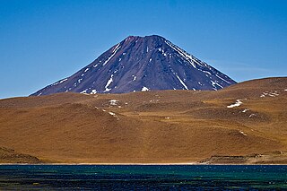
Chiliques is a stratovolcano located in the Antofagasta Region of Chile.
Caichinque is a volcanic complex lying between Salar de Talar and Salar de Capur, in the high Andean plateau of the Antofagasta Region, in Chile. It is located southwest of the Salar de Atacama, directly S of Cerro Miñiques and SE of Cordón Puntas Negras forming part of the main branch of the Andean volcanic chain in this area. Route CH-23 is an approach road to the volcano area and could be impacted by eruptions.

Arintica is a stratovolcano located in Arica y Parinacota Region of Chile, near the border with Bolivia. It lies north of the Salar de Surire.

Volcanism of Chile is a continuous volcanic process that has a strong influence on Chilean landscape, geology, economy and society. Volcanism constantly renews the Chilean landscape with lava flows, lava plateaus, lava domes, cinder cones, stratovolcanoes, shield volcanoes, submarine volcanoes, calderas, diatremes, and maars. Volcanism in Chile as well as in other parts of the world is also associated with multiple natural hazards such as lahars, earthquakes, pyroclastic flows, toxic gases and ash. Continental Chile has a high concentration of active volcanoes due to its location along the Peru–Chile Trench, a subduction zone where the Nazca and Antarctic Plates are driven beneath the South American Plate. Chile has been subject to volcanism since at least late Paleozoic when subduction along the western margin of South America began. Easter Island, Juan Fernández Islands and other oceanic islands of Chile are extinct volcanoes created by hotspots. The Servicio Nacional de Geología y Minería (SERNAGEOMIN) is the statutory agency of the Government of Chile which is responsible for volcano monitoring and hazard assessments. SERNAGEOMIN runs a national Volcano Hazards Program, along with the Observatorio Volcanológico de Los Andes del Sur (OVDAS). The territories of Chile have 92 volcanoes that are considered potentially active, 60 of which have had recorded eruptions in the last 450 years. The volcanoes with most recorded eruptions are:

The Southern Andean Volcano Observatory, also known by its acronyms as OVDAS, is part of Red Nacional de Vigilancia Volcánica, a program of the Chilean National Geology and Mining Service to watch the 43 most dangerous volcanoes of Chile. 2012 there were 30 volcanos under observation.

The San José Mine was a small copper-gold mine located near Copiapó, Atacama Region, Chile. The mine became known internationally for its collapse in 2010, which trapped 33 miners 700 metres (2,300 ft) underground. Its workings are reached by a long sloping roadway with many spiral turns, not by a vertical mineshaft.
Compañía Minera San Esteban Primera is a Chilean mining company, dedicated to the production of copper and gold concentrates. San Esteban's headquarters are located in Providencia, Santiago Metropolitan Region.
Carlosruizite is a sulfate or selenate–iodate mineral with chemical formula: K6(Na,K)4Na6Mg10(SeO4)12(IO3)12·12H2O. It has a low density (specific gravity of 3.36), colorless to pale yellow, transparent mineral which crystallizes in the trigonal crystal system. It forms a series with fuenzalidaite.
In Chile, coal mining is restricted to a few places located in its southern half. Energy originating from coal stands for 11,6% of Chile's electricity consumption. Currently the country is not considered a major producer of coal.

Kunturiri is a volcano in the Andes on the border of Bolivia and Chile which rises up to 5,762 metres (18,904 ft). On the Chilean side it is located in the Arica and Parinacota Region and on the Bolivian side in the Oruro Department, Sajama Province, Curahuara de Carangas Municipality, Sajama Canton as well as in the La Paz Department, Pacajes Province, Calacoto Municipality, Ulloma Canton.
Estratos de San Pedro is the name given to the sedimentary strata of Paleogene age that crop out along San Pedro River, southern Chile. The strata were initially described by Juan Brüggen and later briefly investigated by Henning Illies who estimated their thickness at 1,000 metres (3,300 ft). The strata are made up of conglomerate, sandstone and mudstone. The clasts of the conglomerates are made up of metamorphic rock and the disposition of the conglomerates varies from clast-supported to matrix-supported. The sandstone and mudstone contains layers of lignite coal that exceed 30 centimetres (12 in) in thickness.
Estratos de Pupunahue is the name given to the sedimentary strata of Oligocene-Miocene age that crop out in Pupunahue and Mulpún near Valdivia, Chile. Outside this locality Estratos de Pupunahue extends below the surface over a larger area. The thickness of the strata varies from a few meters to 530 meters. The strata were initially described by Henning Illies. The strata are made up of conglomerate, sandstone and mudstone. The clast of the conglomerates are made up of metamorphic rock and the disposition of the conglomerates varies from clast-supported to matrix-supported. The sandstone and mudstone contain layers of lignite coal that exceed 30 cm in thickness.
Cheuquemó Formation is a geological formation of sedimentary rock in south-central Chile. The sediments of the formation were deposited during the Late Oligocene and Early Miocene epochs. The formations lower sections are made up of conglomerate, then successions of sandstone, tuff and mudstone rich in organic material follows. The formation indicates that sedimentation occurred in an estuarine (paralic) and other non-marine (continental) environments. It contains fossils of the following genera: Mytilus, Cardium and Turritella. Stratigraphically it overlies the Bahía Mansa Metamorphic Complex and underlies the Miocene Santo Domingo Formation.
Parga Formation is a geological formation of sedimentary rock in south-central Chile. The sediments of the formation were deposited during the Late Oligocene and Middle Miocene epochs. The formation's lower sections are made up of conglomerate, sandstone and mudstone some of which is rich in organic material. Additionally there are thin beds of tuff and coal. The formation's composition indicates that sedimentation occurred in an estuarine (paralic) and marine environments. Stratigraphically it overlies the Bahía Mansa Metamorphic Complex and is similar in age and type to Lacui Formation to the south and Cheuquemó and Santo Domingo Formation to the north. It is overlain across an angular unconformity by Pliocene or Quaternary sediments. The formation is intruded by porphyritic trachyte of Oligocene to Miocene age. The outcrops of the formation are restricted to a NW-SE strip near Caleta Parga north of the estuary of Maullín River.
Mininco Formation is a geological formation composed of sediments that deposited during the Pliocene in central Chile. Near Angol the formation reaches thicknesses of up to 300 m. The upper strata of the formation contain tuff layers and coal beds that are rich in leaf fossils. Other fossils that have been found in the formation include fresh-water diatoms and bivalves.
Temuco Formation a sedimentary formation near the city of Temuco in southern Chile. The formation crops out in the western part of Labranza Basin at the footfills of the Chilean Coast Range. It overlies the Bahía Mansa Metamorphic Complex and underlies sediments of Holocene age. The formation is thought to represent ancient river systems of low and intermediated energy near an area of volcanism around cerro Ñielol.

The Colombian Geological Survey (CGS) is a scientific agency of the Colombian government in charge of contributing to the socioeconomic development of the nation through research in basic and applied geosciences of the subsoil, the potential of its resources, evaluating and monitoring threats of geological origin, managing the geoscientific knowledge of the nation, and studying the nuclear and radioactive elements in Colombia.
Collacagua is a Chilean town. It is a small Aymara hamlet in the highlands of the Tarapacá Region (Chile). Collacagua is located 86 km from Pica, between the towns of Cancosa and Lirima. The houses of which the oldest are made of stone, adobe and mud. The latter are similar to the ancestral Aymara architectural style but their materials are not the same.
