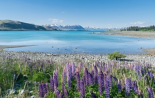
A moraine-dammed lake occurs when the terminal moraine has prevented some meltwater from leaving the valley. Its most common shape is that of a long ribbon. Example of moraine dammed lakes include:

The Los Ríos Region is one of Chile's 16 regions, the country's first-order administrative divisions. Its capital is Valdivia. It began to operate as a region on October 2, 2007, having been created by subdividing the Los Lagos Region in southern Chile. It consists of two provinces: Valdivia and the newly created Ranco Province, which was formerly part of Valdivia Province.

Panguipulli is a city and commune in Valdivia Province, southern Chile, administered by the Municipality of Panguipulli. It is located on the western edge of Panguipulli Lake, and is on a moraine in the Chilean Central Valley. Most of the commune lies on Andean mountains and valleys.

Huilo-Huilo Biological Reserve is a private for profit natural reserve and ecotourism area in southern Chile. It is by the community of Neltume along the international road to Hua Hum Pass near the border to Argentina. The reserve has unique hotels, including Montana Mágica, the Nothofagus hotel, cabins, and a lodge for backpackers. The grounds also include a brewery, various animal habitats, a funicular, and many miles of trails. The reserve includes many waterfalls and the eastern slopes of Mocho-Choshuenco, a glacial compound stratovolcano.

The Panguipulli Lake is one of the "Seven Lakes" in Panguipulli municipality, southern Chile. The lake is of glacial origin and it is enclosed by mountain ranges of the Andes, on all sides except the west, where the town of Panguipulli lies in the Chilean Central Valley. The lake is drained by the Enco River that flows south to Riñihue Lake.

The Seven Lakes is a group of lakes which belong to the same drainage basin that starts in the Lácar Lake and ends in Corral Bay.
The Riñihue Lake is a lake of glacial origin in eastern Valdivia Province, southern Chile. It is surrounded by several mountains. The eastern side receives the waters of the Panguipulli Lake by the Enco River, its main contributor. It is the last of the Seven Lakes chain. In the west it is cut into two arms by the Tralcán Mount, and on the east side lies the Mocho-Choshuenco volcano. In the south the lake is bounded by the Cerros de Quimán mountains.
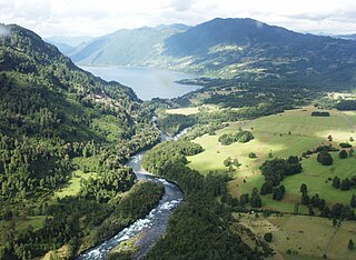
Enco River is a river in Panguipulli commune in southern Chile. By flowing from Panguipulli Lake to Riñihue Lake Enco River carries the water of the six upper lakes of the Seven Lakes area into Riñihue, the last lake in the chain. Located between the piedmont of Mocho-Choshuenco Volcano and Cerro Maltusado Enco River is unusual because it drains Panguipulli Lake through its eastern and mountainous end rather than allowing the lake to drain through the low moraine hills in the west.

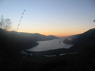
Pirihueico Lake is one of Seven Lakes in Panguipulli Commune, southern Chile. The lake is of glacial origin and it is enclosed mountains of the Andes. It is located in a geological fault that includes Panguipulli Lake and Lácar Lake in Argentina. The lake is drained by Fui River. Pirihueico Lake is used as a waterway due to its elonged shape. It is used mostly by vehicles traveling to or from Argentina by the nearby Huahum Pass. For that reason there is a ferry operating between Puerto Fuy and Puerto Pirihueico in the western respectively eastern extreme of the lake.
Fuy River is a river in the commune of Panguipulli, southern Chile. It drains Pirihueico Lake and flows southward along the village of Neltume where it joins the Neltume River and together they create the Panguipulli Lake. The river's origin is near the village of Puerto Fuy (es).
Llanquihue River is a river in the commune of Panguipulli, southern Chile. It is formed by the union of Neltume River and Fui River. Llanquihue River flows in a south and westward and outflows in Panguipulli Lake.

The Pellaifa Lake is one of the "Seven Lakes" in Panguipulli municipality, southern Chile. The lake is of glacial origin and lies in an area of hot springs.

The Pullinque Lake is one of the "Seven Lakes" in Panguipulli municipality, southern Chile. The lake is of glacial origin and lies between Calafquén and Panguipulli Lake. Pullinque Hydroelectric Plant is located near the southwestern outflow of the lake.
Choshuenco is a village on the eastern edge of Panguipulli Lake in Panguipulli commune, Los Lagos Region, Chile. It is 4 kilometres (2.5 mi) south of the 203-CH route that goes from Lanco to Huahum Pass. It is 33 kilometres (21 mi) west of the Argentina border.
The North Patagonian Batholith is a series of igneous plutons in the Patagonian Andes of Argentina and Chile.
The Reigolil-Pirihueico Fault is a second-order geological fault located in the Chilean and Argentine Andes. As the name implies, it runs from Pirihueico Lake to Reigolil Valley. Reigolil-Pirihueico Fault run in north–south direction and is roughly parallel to the larger Liquiñe-Ofqui Fault, which is located 15 to 20 km west of it to which it is considered a branch of. East of Reigolil-Pirihueico Fault, close or along the Argentina-Chile boundary, are a string of volcanoes pliocene to quaternary volcanoes: Lanín, Pirihueico, Huanquihué, Quelguenco and Chihuío.
Santo Domingo Formation is a mainly marine Miocene sedimentary formation located in south–central Chile. The formation was defined by R. Martínez Pardo and Mario Pino in 1979 and named after the roadcut locality they studied about 19 kilometres (12 mi) southeast of Valdivia. Sediments of the formation accumulated in Valdivia and Osorno–Llanquihue Basin.

The Coastal Batholith of central Chile is a group of plutons in the Chilean Coast Range of Central Chile appearing contiguously from 33° S to 38° S. At a latitude of 40° S an outlying group of plutons of the batholith appear in a more eastward position in the Andes.
Tralcán Formation is a sedimentary formation of Triassic age in Los Ríos Region in south–central Chile. It overlies unconformably the Trafún Metamorphic Complex. Tralcán Formation and nearby Panguipulli Formation form possibly the remnants of an ancient lake and river system. The formation is named after Mount Tralcán on the western edge of Riñihue Lake.
Panguipulli Formation is a sedimentary formation of Triassic age located in Los Ríos Region and southernmost Araucanía Region in south–central Chile. The formation is variously covered by Quaternary lavas in the east and Quaternary moraines, Holocene alluvium and colluvium in the west. The formation and make up possibly the remnants of an ancient lake and river system. The formation is named after the town of Panguipulli on the western edge of Panguipulli Lake. The formation has evidence of low grade metamorphism and is locally intruded by plutons of the North Patagonian Batholith that are of Jurassic, Cretaceous and Miocene age.
