Related Research Articles

The Andes, Andes Mountains or Andean Mountain Range are the longest continental mountain range in the world, forming a continuous highland along the western edge of South America. The range is 8,900 km (5,530 mi) long and 200 to 700 km wide and has an average height of about 4,000 m (13,123 ft). The Andes extend from South to North through seven South American countries: Argentina, Chile, Bolivia, Peru, Ecuador, Colombia, and Venezuela.

The Anatolian sub-plate is a continental tectonic plate that is separated from the Eurasian plate and the Arabian plate by the North Anatolian Fault and the East Anatolian Fault respectively. Most of the country of Turkey is located on the Anatolian plate. Most significant earthquakes in the region have historically occurred along the northern fault, such as the 1939 Erzincan earthquake. The devastating 2023 Turkey–Syria earthquakes occurred along the active East Anatolian Fault at a strike-slip fault where the Arabian plate is sliding past the Anatolian plate horizontally.

The Los Angeles Basin is a sedimentary basin located in Southern California, in a region known as the Peninsular Ranges. The basin is also connected to an anomalous group of east–west trending chains of mountains collectively known as the Transverse Ranges. The present basin is a coastal lowland area, whose floor is marked by elongate low ridges and groups of hills that is located on the edge of the Pacific plate. The Los Angeles Basin, along with the Santa Barbara Channel, the Ventura Basin, the San Fernando Valley, and the San Gabriel Basin, lies within the greater Southern California region. The majority of the jurisdictional land area of the city of Los Angeles physically lies within this basin.

The Scotia plate is a minor tectonic plate on the edge of the South Atlantic and Southern oceans. Thought to have formed during the early Eocene with the opening of the Drake Passage that separates Antarctica and South America, it is a minor plate whose movement is largely controlled by the two major plates that surround it: the Antarctic plate and the South American plate. The Scotia plate takes its name from the steam yacht Scotia of the Scottish National Antarctic Expedition (1902–04), the expedition that made the first bathymetric study of the region.

Viedma is a subglacial volcano whose existence is questionable. It is supposedly located below the ice of the Southern Patagonian Ice Field, an area disputed between Argentina and Chile. The 1988 eruption deposited ash and pumice on the ice field and produced a mudflow that reached Viedma Lake. The exact position of the edifice is unclear, both owing to the ice cover and because the candidate position, the "Viedma Nunatak", does not clearly appear to be of volcanic nature.

The Northern Patagonian Ice Field, located in southern Chile, is the smaller of two remnant parts in which the Patagonian Ice Sheet in the Andes Mountains of southern South America can be divided. It is completely contained within the boundaries of Laguna San Rafael National Park.

The Los Ríos Region is one of Chile's 16 regions, the country's first-order administrative divisions. Its capital is Valdivia. It began to operate as a region on October 2, 2007, having been created by subdividing the Los Lagos Region in southern Chile. It consists of two provinces: Valdivia and the newly created Ranco Province, which was formerly part of Valdivia Province.

Puyuhuapi Volcanic Group is a volcanic group of cinder cones located at the head of Puyuhuapi Channel, in the Aysén del General Carlos Ibáñez del Campo Region of Chile.

The Liquiñe-Ofqui Fault is major geological fault that runs a length of roughly 1,200 kilometres (750 mi) in a NNE-SSW orientation and exhibits current seismicity. It is located in the Chilean Northern Patagonian Andes. It is a dextral intra-arc strike-slip fault. Most large stratovolcanoes of the Southern Volcanic Zone of the Andes are aligned by the fault which allows for the movement of magma and hydrothermal fluids.
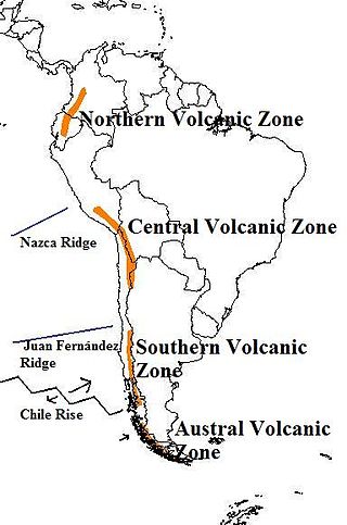
The Andean Volcanic Belt is a major volcanic belt along the Andean cordillera in Argentina, Bolivia, Chile, Colombia, Ecuador, and Peru. It is formed as a result of subduction of the Nazca plate and Antarctic plate underneath the South American plate. The belt is subdivided into four main volcanic zones which are separated by volcanic gaps. The volcanoes of the belt are diverse in terms of activity style, products, and morphology. While some differences can be explained by which volcanic zone a volcano belongs to, there are significant differences within volcanic zones and even between neighboring volcanoes. Despite being a type location for calc-alkalic and subduction volcanism, the Andean Volcanic Belt has a broad range of volcano-tectonic settings, as it has rift systems and extensional zones, transpressional faults, subduction of mid-ocean ridges and seamount chains as well as a large range of crustal thicknesses and magma ascent paths and different amounts of crustal assimilations.

The geology of Chile is a characterized by processes linked to subduction, such as volcanism, earthquakes, and orogeny. The building blocks of Chile's geology were assembled during the Paleozoic Era when Chile was the southwestern margin of the supercontinent Gondwana. In the Jurassic, Gondwana began to split, and the ongoing period of crustal deformation and mountain building known as the Andean orogeny began. In the Late Cenozoic, Chile definitely separated from Antarctica, and the Andes experienced a significant rise accompanied by a cooling climate and the onset of glaciations.
Sollipulli is an ice-filled volcanic caldera and volcanic complex, which lies southeast of the small town of Melipeuco in the La Araucanía Region, Chile. It is part of the Southern Volcanic Zone of the Andes, one of the four volcanic belts in the Andes chain.

Colonia Glacier is a valley glacier located in the Northern Patagonian Ice Field, Chile. The glacier spills out to the southeast from an ice plateau north of Cerro Arenales and has its terminus about 4 km (2.5 mi) from Colonia Lake. Colonia Glacier dams two lakes; Cachet II and Arco Lake. The ice dam containing the waters of Cachet II Lake fails regularly, which generates glacial lake outburst floods.

The Andean orogeny is an ongoing process of orogeny that began in the Early Jurassic and is responsible for the rise of the Andes mountains. The orogeny is driven by a reactivation of a long-lived subduction system along the western margin of South America. On a continental scale the Cretaceous and Oligocene were periods of re-arrangements in the orogeny. The details of the orogeny vary depending on the segment and the geological period considered.
The Scandinavian Mountains or the Scandes is a mountain range that runs through the Scandinavian Peninsula. The western sides of the mountains drop precipitously into the North Sea and Norwegian Sea, forming the fjords of Norway, whereas to the northeast they gradually curve towards Finland. To the north they form the border between Norway and Sweden, reaching 2,000 metres (6,600 ft) high at the Arctic Circle. The mountain range just touches northwesternmost Finland but are scarcely more than hills at their northernmost extension at the North Cape.

The tectonic evolution of the Transantarctic Mountains appears to have begun when Antarctica broke away from Australia during the late Cretaceous and is ongoing, creating along the way some of the longest mountain ranges formed by rift flank uplift and associated continental rifting. The Transantarctic Mountains (TAM) separate East and West Antarctica. The rift system that formed them is caused by a reactivation of crust along the East Antarctic Craton. This rifting or seafloor spreading causes plate movement that results in a nearby convergent boundary which then forms the mountain range. The exact processes responsible for making the Transantarctic Mountains are still debated today. This results in a large variety of proposed theories that attempt to decipher the tectonic history of these mountains.
Fueguino is a volcanic field in Chile. The southernmost volcano in the Andes, it lies on Tierra del Fuego's Cook Island and also extends over nearby Londonderry Island. The field is formed by lava domes, pyroclastic cones, and a crater lake.

Patagonia comprises the southernmost region of South America, portions of which lie on either side of the Argentina-Chile border. It has traditionally been described as the region south of the Rio, Colorado, although the physiographic border has more recently been moved southward to the Huincul fault. The region's geologic border to the north is composed of the Rio de la Plata craton and several accreted terranes comprising the La Pampa province. The underlying basement rocks of the Patagonian region can be subdivided into two large massifs: the North Patagonian Massif and the Deseado Massif. These massifs are surrounded by sedimentary basins formed in the Mesozoic that underwent subsequent deformation during the Andean orogeny. Patagonia is known for its vast earthquakes and the damage they cause.

The Huincul Fault or Huincul Fault Zone is an east-to-west-oriented, continental-scale fault that extends from the Neuquén Basin eastwards into the Argentine Shelf. To the west, it has been proposed to extend across the Andes to the Chilean Coast Range.

The Chile Ridge, also known as the Chile Rise, is a submarine oceanic ridge formed by the divergent plate boundary between the Nazca plate and the Antarctic plate. It extends from the triple junction of the Nazca, Pacific, and Antarctic plates to the Southern coast of Chile. The Chile Ridge is easy to recognize on the map, as the ridge is divided into several segmented fracture zones which are perpendicular to the ridge segments, showing an orthogonal shape toward the spreading direction. The total length of the ridge segments is about 550–600 km.
References
- ↑ Georgieva, Viktoria; Melnick, Daniel; Schildgen, Taylor F.; Ehlers, Todd A.; Lagabrielle, Yves; Enkelmann, Eva; Strecker, Manfred R. (2016). "Tectonic control on rock uplift, exhumation, and topography above an oceanic ridge collision: Southern Patagonian Andes (47°S), Chile". Tectonics. 35 (6): 1317. Bibcode:2016Tecto..35.1317G. doi: 10.1002/2016TC004120 .
| | This article about structural geology is a stub. You can help Wikipedia by expanding it. |