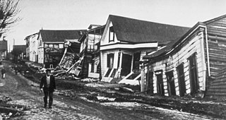
The 1960 Valdivia earthquake and tsunami or the Great Chilean earthquake on 22 May 1960 was the most powerful earthquake ever recorded. Various studies have placed it at 9.4–9.6 on the moment magnitude scale. It occurred in the afternoon, and lasted for approximately 10 minutes. The resulting tsunamis affected southern Chile, Hawaii, Japan, the Philippines, eastern New Zealand, southeast Australia, and the Aleutian Islands.

The Maule Region is one of Chile's 16 first order administrative divisions. Its capital is Talca. The region derives its name from the Maule River which, running westward from the Andes, bisects the region and spans a basin of about 20,600 km2. The Maule river is of considerable historic interest because, among other reasons, it marked the southern limits of the Inca Empire.

The Biobío Region is one of Chile's sixteen regions. With a population of 1.5 million, thus being the third most populated region in Chile, it is divided into three provinces: Arauco, Biobío and Concepción. The latter contains its capital and largest city, Concepción, a major city and metro area in the country. Los Ángeles, capital of the Biobío Province, is another important city in the region.
Megathrust earthquakes occur at convergent plate boundaries, where one tectonic plate is forced underneath another. The earthquakes are caused by slip along the thrust fault that forms the contact between the two plates. These interplate earthquakes are the planet's most powerful, with moment magnitudes (Mw) that can exceed 9.0. Since 1900, all earthquakes of magnitude 9.0 or greater have been megathrust earthquakes.
The 1922 Vallenar earthquake occurred with a moment magnitude of 8.5–8.6 and a tsunami magnitude of 8.7 in the Atacama Region of Chile, near the border with Argentina on 11 November at 04:32 UTC. It triggered a destructive tsunami that caused significant damage to the coast of Chile and was observed as far away as Australia.

The 2010 Chile earthquake and tsunami occurred off the coast of central Chile on Saturday, 27 February at 03:34 local time, having a magnitude of 8.8 on the moment magnitude scale, with intense shaking lasting for about three minutes. It was felt strongly in six Chilean regions that together make up about 80 percent of the country's population. According to the United States Geological Survey (USGS) the cities experiencing the strongest shaking—VIII (Severe) on the Mercalli intensity scale (MM)—were Concepción, Arauco, and Coronel. According to Chile's Seismological Service, Concepción experienced the strongest shaking at MM IX (Violent). The earthquake was felt in the capital Santiago at MM VII or MM VIII. Tremors were felt in many Argentine cities, including Buenos Aires, Córdoba, Mendoza, and La Rioja. Tremors were felt as far north as the city of Ica in southern Peru.
The timeline of relief efforts after the 2010 Chile earthquake of 27 February 2010 involves the sequence of events in the days following a highly destructive 8.8 Mw earthquake with an epicentre just offshore of the Maule Region, see Maule, Chile.
The 1730 Valparaíso earthquake occurred at 04:45 local time on July 8. It had an estimated magnitude of 9.1–9.3 and triggered a major tsunami with an estimated magnitude of Mt 8.75, that inundated the lower parts of Valparaíso. The earthquake caused severe damage from La Serena to Chillan, while the tsunami affected more than 1,000 km (620 mi) of Chile's coastline.

Pichilemu post office building was a building located in Pichilemu, Chile, which served as the city's post office until 26 February 2010, the day before a magnitude 8.8 earthquake hit central Chile. The building was located in front of the Pichilemu Police station. It was demolished between 2 July until 3 July 2010.
The 1985 Rapel Lake earthquake occurred on 8 April at 21:56:59 local time with a moment magnitude of 7.5 and a maximum perceived intensity of VI (Strong). The shock was centered 75 kilometres (47 mi) southwest of Santiago, Chile, with a focal depth of 37.8 km (23 mi).
The Pichilemu Fault, also referred to as the Pichilemu-Vichuquén Fault, is a Chilean geological fault, located in Libertador General Bernardo O'Higgins Region, some kilometers away from Pichilemu, at a depth of 15 kilometres (9.3 mi). The fault is 40 kilometres (25 mi) long and 20 kilometres (12 mi) wide.

The 2010 Pichilemu earthquakes, also known as the Libertador O'Higgins earthquakes, were a pair of intraplate earthquakes measuring 6.9 and 7.0 Mw that struck Chile's O'Higgins Region on 11 March 2010 about 16 minutes apart. The earthquakes were centred 15 kilometres (9.3 mi) northwest of the city of Pichilemu.

The 1928 Talca earthquake occurred on 1 December at 00:06 local time near Curepto, Maule Region, Chile, with an estimated magnitude of 7.6 MW, 8.3 MS and 7.9 ML. In Talca, it lasted 1 minute 45 seconds.

The Valparaíso earthquake of April 2017 was a strong earthquake that shook the cities of Valparaíso and Santiago on Monday, April 24, 2017, at 18:38 local time. Its epicenter was located off the coast of the Valparaíso Region and had a magnitude of 6.9 Mw. On the scale of Mercalli, the earthquake reached an intensity of VII.
The 1657 Concepción earthquake occurred on March 15 at 20:00 local time off the coast of Concepción, Biobío Region in the Spanish Empire. The earthquake caused severe damage along the coast, and generated a large tsunami in the Bay of Concepción. At least 40 people were killed, the majority due to drowning from the tsunami. The town of Concepción was the hardest hit, with the earthquake and tsunami totally destroying it.