Yumbel

Last updated • 2 min readFrom Wikipedia, The Free Encyclopedia
Yumbel
Celebracion San Sebastian 2017 (7).jpg
Traditional religious holiday of St. Sebastián of Yumbel.
Bandera de Yumbel.png
Escudo de Yumbel.svg
Txu-oclc-224571178-sj18-08.jpg
Chile location map.svg
Red pog.svg
Yumbel
Location in Chile
Coordinates(City): 37°8′S72°32′W / 37.133°S 72.533°W / -37.133; -72.533
Country Chile
Region Bío Bío
Province Bío Bío
Government
  Type City
Area
[3]
  Total727.0 km2 (280.7 sq mi)
Elevation
87 m (285 ft)
Population
 (2012 Census) [3]
  Total20,034
  Density28/km2 (71/sq mi)
   Urban
10,935
   Rural
9,563
Sex
[3]
  Men10,442
  Women10,056
Time zone UTC−4 (CLT)
  Summer (DST) UTC−3 (CLST)
Area code 56 + 43
Website Municipality of Yumbel

Yumbel is a city and commune of the Province of Bío Bío in the region of the same name, Chile.

Contents

History

Yumbel originated from the small fort of San Felipe de Austria, raised in 1585 by Governor Alonso de Sotomayor, on the cerro del Centinela (Hill of the Sentinel). This fort was destroyed by the Mapuche and replaced in 1603, by Governor Alonso de Ribera as fort Santa Lucia de Yumbel. Destroyed in 1621 it was rebuilt the same year. It remained in use until 1648 when it was abandoned and its garrison sent to the fort of Nacimiento, Chile. Governor Ángel de Peredo again constructed it in 1663 as fort Nuestra Señora de Almudena. When Francisco de Meneses Brito populated it three years later he renamed it San Carlos de Austria de Yumbel. During the term of Diego González Montero Justiniano a town that had evolved was given the name of Santa Lucia de Yumbel. Governor Antonio de Guill y Gonzaga gave it the recognition as a town in 1766. It grew little until the Chilean War of Independence when it was occupied by both sides at times and then was burned by the Spanish guerrilla Juan Manuel Picó and the end of 1820. [4]

The town was reduced to ruins in the earthquake of February 20, 1835, and was reestablished to the north of the old location on August 29, 1836. It alternated for some time with the town of San Luis Gonzaga as the capital of the Department of Rere, until the decree of June 2, 1853 confirmed Yumbel as the capital. On March 19, 1871, Yumbel was made a city. [4]

Geography

The city lies a few kilometers northeast of the confluence of the Laja and Bío Bío rivers. The Biobío River marks boundary between two natural regions of Chile, the Zona Central to the north and the Zona Austral to the south.

Demographics

According to the 2002 census of the National Statistics Institute, Yumbel spans an area of 727 km2 (281 sq mi) and has 20,498 inhabitants (10,442 men and 10,056 women). Of these, 10,935 (53.3%) lived in urban areas and 9,563 (46.7%) in rural areas. The population grew by 0.2% (38 persons) between the 1992 and 2002 censuses. [3]

Administration

As a commune, Yumbel is a third-level administrative division of Chile administered by a municipal council, headed by an alcalde who is directly elected every four years. The 2008-2012 alcalde is Camilo Cabezas Vega (PH). [1] [2]

Within the electoral divisions of Chile, Yumbel is represented in the Chamber of Deputies by Jorge Sabag (PDC) and Frank Sauerbaum (RN) as part of the 42nd electoral district, together with San Fabián, Ñiquén, San Carlos, San Nicolás, Ninhue, Quirihue, Cobquecura, Treguaco, Portezuelo, Coelemu, Ránquil, Quillón, Bulnes and Cabrero. The commune is represented in the Senate by Alejandro Navarro Brain (MAS) and Hosain Sabag Castillo (PDC) as part of the 12th senatorial constituency (Biobío-Cordillera).

Related Research Articles

<span class="mw-page-title-main">Cobquecura</span> Town and Commune in Ñuble, Chile

Cobquecura is a commune in the Region of Ñuble in the Province of Itata Chile's Region of Ñuble. The town is located on the northwest Pacific coast of the Itata Province about 420 km (261 mi) southwest of the national capital of Santiago.

<span class="mw-page-title-main">Quirihue</span> City and Commune in Ñuble, Chile

Quirihue is a Chilean city in Quirihue, Itata Province, Ñuble Region. It is located about 72 kilometers northwest of Chillán and 410 km southwest of Santiago.

<span class="mw-page-title-main">San Pedro de la Paz</span> City and Commune in Biobío, Chile

San Pedro de la Paz is a Chilean city and commune located in the Concepción Province, Biobío Region. It has some 80,447 inhabitants according to the 2002 national census. In 2005, the Pedro Aguirre Cerda avenue, the main avenue in the city, was completed. Most of the inhabitants of this comuna commute daily to Concepción – either by car, bus or train – over the Biobío River. It is considered to be part of Greater Concepción conurbation.

<span class="mw-page-title-main">Lebu, Chile</span> City and commune in the Bío Bío Region, Chile

Lebu is a port city and commune in central Chile administered by the Municipality of Lebu. Lebu is also the capital of Arauco Province in Bío Bío Region. It lies on the south bank of the mouth of the Lebu River.

Tucapel is a town and commune in the Bío Bío Province, Bío Bío Region, Chile. It was once a region of Araucanía named for the Tucapel River. The name of the region derived from the rehue and aillarehue of the Moluche people of the area between the Lebu and the Lleulleu Rivers, who were famed for their long resistance to the Spanish in the Arauco War. Tucapel is also the name of a famous leader from that region in the first resistance against the Spanish mentioned in Alonso de Ercilla's epic poem La Araucana. Formerly belonging to the Ñuble Province, in the Yungay Department. Near the town of Tucapel is the Plaza de San Diego de Tucapel. The capital of the commune is the town of Huépil, moving the municipality from Tucapel in 1967. In Mapudungun the name Huépil means "To seize or to take by force".

<span class="mw-page-title-main">Arauco, Chile</span> City and commune in the Bío Bío Region, Chile

Arauco is a city and commune in Chile, located in Arauco Province in the Bío Bío Region. The meaning of Arauco means Chalky Water in Mapudungun. The region was a Moluche aillarehue. The Spanish settlements founded here during the Conquest of Chile were destroyed on numerous occasions by the Mapuche during the Arauco War.

<span class="mw-page-title-main">Ñiquén</span> Commune in Ñuble, Chile

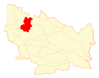
Ñiquén is a commune of the Punilla Province, located in the north of the Ñuble Region of Chile. Geographically, it is delimited by the Perquilauquén River to the north and the Ñiquén River in the south. Its boundary to the north is the commune of Parral and to the west that of Cauquenes both in the Maule Region, to the south with the commune of San Carlos, and to the east with San Fabian de Alico. The town of San Gregorio is the capital of this commune.

<span class="mw-page-title-main">Hualqui</span> City and Commune in Bío Bío, Chile

Hualqui is a Chilean city and commune in the Concepción Province, Biobio Region. It is also part of the Greater Concepcion conurbation, although it maintains a rural profile. It had a population of 24,333 inhabitants according to the 2017 census.

<span class="mw-page-title-main">Santa Juana</span> City and Commune in Bío Bío, Chile

Santa Juana is a city and commune of the Concepción Province in the Bío Bío Region of Chile. It lies south and west of the Biobío River in the valley of Catirai and is 48 kilometers from Concepción, Chile.

San Rosendo is a Chilean city and commune in Bío Bío Province, Bío Bío Region.

Negrete is a Chilean town and commune in Bío Bío Province, Bío Bío Region. It is bordered by the commune of Los Ángeles to the north, Renaico to the south, Mulchén to the east and Nacimiento to the west.

<span class="mw-page-title-main">Bulnes, Chile</span> City and Commune in Ñuble, Chile

Bulnes is a Chilean city and commune in Diguillín Province, Ñuble Region.

<span class="mw-page-title-main">Ninhue</span> Town and Commune in Ñuble, Chile

Ninhue is a commune and town in the Itata Province, Ñuble Region, Chile.

<span class="mw-page-title-main">San Nicolás, Chile</span> Town and Commune in Ñuble, Chile

San Nicolás is a Chilean town and commune in Punilla Province, Ñuble Region.

<span class="mw-page-title-main">Coelemu</span> City and Commune in Ñuble, Chile

Coelemu is a Chilean commune and city in Itata Province, Ñuble Region. According to the 2002 census, the commune population was 16,082 and has an area of 342.3 km2 (132 sq mi).

<span class="mw-page-title-main">Ránquil</span> Commune in Ñuble, Chile

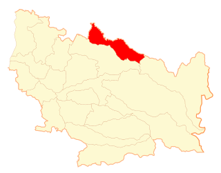
Ránquil is a Chilean commune in Itata Province, Ñuble Region. The communal capital is the town of Ránquil.

<span class="mw-page-title-main">Quillón</span> City and Commune in Ñuble, Chile

Quillón is a Chilean city and commune and Diguillín Province, Ñuble Region.

<span class="mw-page-title-main">Santa Bárbara, Chile</span> City and Commune in Bío Bío, Chile

Santa Bárbara is a Chilean city and commune in Bío Bío Province, Bío Bío Region. In 2004 a great portion of its territory was taken off to form the new commune of Alto Bío Bío.

Rere is a town located in the commune of Yumbel, Province of Biobío, in the Bío Bío Region of Chile. It takes its name from the Moluche language of the indigenous confederation, or aillarehue, that occupied both sides of the Claro River and made up the greater confederation, or Butalmapu, between the Itata and Bio Bio Rivers. In 1603, then Royal Governor of Chile under Spanish rule Alonso de Ribera was to declare the erection of the areas first fort naming it Nuestra Señora de la Buena Esperanza. Later, in 1765, the town of Villa de San Luis Gonzaga de Rere was founded on that site by governor Antonio de Guill y Gonzaga. Today Rere sits 21 km west of the town of Yumbel.

Cabrero is a city and commune in the Bío Bío Province, Bío Bío Region, Chile.

References

  1. 1 2 "Asociación Chilena de Municipalidades" (in Spanish). Retrieved 23 February 2011.
  2. 1 2 "Municipality of Yumbel" (in Spanish). Retrieved 23 February 2011.
  3. 1 2 3 4 "National Statistics Institute" (in Spanish). Retrieved 1 January 2011.
  4. 1 2 Francisco Solano Asta-Buruaga y Cienfuegos (1899). Diccionario geográfico de la República de Chile (in Spanish) (Second ed.). New York: D. Appleton Company. p. 898. Retrieved 23 February 2011.