Pelluhue

Last updated
Pelluhue


Escudo Pelluhue.png
Coat of arms
Comuna de Pelluhue.svg
Map of the Pelluhue commune in the Maule Region
Chile location map.svg
Red pog.svg
Pelluhue
Location in Chile
Coordinates(city): 35°48′S72°34′W / 35.800°S 72.567°W / -35.800; -72.567 Coordinates: 35°48′S72°34′W / 35.800°S 72.567°W / -35.800; -72.567
Country Chile
Region Maule
Province Cauquenes
Government
[1]
  Type Municipality
   Alcalde Carlos Zúñiga Villaseñor (UDI)
Area
[2]
  Total371.4 km2 (143.4 sq mi)
Elevation
11 m (36 ft)
Population
 (2012 Census) [2]
  Total6,620
  Density18/km2 (46/sq mi)
   Urban
6,414
   Rural
3,877
Demonym(s) Pelluhuano
Sex
[2]
  Men3,408
  Women3,006
Time zone UTC-4 (CLT [3] )
  Summer (DST) UTC-3 (CLST [4] )
Postal code
3710000
Area code(s) 56 + 73
Website www.munipelluhue.cl
Fotografias Pelluhue1.jpg
Las Brisas.jpg
Fotografias

Pelluhue (in Mapudungun: land of clams) is a town and commune in the Cauquenes Province of central Chile's seventh region of Maule.

Contents

Geography

The commune of Pelluhue has an area of 371.4 km2 (143 sq mi) [2] and is bordered on the north by Chanco, on the south by Cobquecura (Ñuble Region), on the east by Cauquenes and on the west by the Pacific Ocean. Its seat is the town of Curanipe.

Demography

Although Curanipe is the municipal seat, Pelluhue has a greater population, both permanent and seasonal. According to the 2002 census of the National Statistics Institute, Pelluhue spans an area of 371.4 km2 (143 sq mi) and has 6,414 inhabitants (3,408 men and 3,006 women). Of these, 3,877 (60.4%) lived in urban areas and 2,537 (39.6%) in rural areas. Because of its appeal as a tourism and retirement center,[ citation needed ] Pelluhue has been steadily growing over the last two decades. Its population increase rate has been one of the highest in the Maule Region, growing by 17.2% (943 persons) between the 1992 and 2002 censuses. [2]

History

Both towns, Pelluhue and Curanipe, are nowadays popular coastal resorts. Pelluhue evolved from a humble fishermen's cove to a crowded summer resort in less than 50 years. The town's population swells to over several thousand in the summer week-ends when vacationers from the hinterland (Cauquenes, Linares, Talca, Parral) visit the seaside.

Curanipe has a more "patrician" past, having been already a well-known and secluded coastal resort for the Cauquenes elite and a proud "minor port", in the mid- and late 19th century and early 20th century. Both Pelluhue and Curanipe were part of the municipality of Chanco until 1979. The municipality and commune (Spanish: comuna ) of Pelluhue was officially created on October 26, 1979, when both towns, together with their adjacent territories, formed a new municipality.

The Curanipe parish church of Santo Toribio is a preserved religious building overlooking the town.

From the ecclesiastical point of view, Pelluhue belongs to the Parish of Curanipe, of the Diocese of Linares, Chile.

Administration

As a commune, Pelluhue is a third-level administrative division of Chile administered by a municipal council, headed by an alcalde who is directly elected every four years. The 2008-2012 alcalde is Carlos Zúñiga Villaseñor (UDI). [1]

Within the electoral divisions of Chile, Pelluhue is represented in the Chamber of Deputies by Guillermo Ceroni (PPD) and Ignacio Urrutia (UDI) as part of the 40th electoral district, together with Longaví, Retiro, Parral, Cauquenes and Chanco. The commune is represented in the Senate by Hernán Larraín (UDI) and Ximena Rincón González (PDC) as part of the 11th senatorial constituency (Maule-South).

Attractions and tourism

In the southernmost corner of the municipality, which borders the Bío Bío Region, lies the semi-isolated beach of Tregualemu, next to which there are two old, large rural houses of Chilean colonial style.

The "Los Ruiles" National Reserve is a park in the easternmost part of the municipality, located in the foothills of the "Cordillera de la Costa". A small oasis next to the road that connects Chanco and Cauquenes, the park contains many native species of trees and plants. Several of them are unique to the region and some are in danger of extinction. The reserve has a surface of 29 hectares. There is a reception area, several picnic tables and two footpaths.

Earthquake

On February 27, 2010, Pelluhue and Curanipe were partially destroyed by an earthquake measuring 8.8 on the moment magnitude scale, and its associated tsunami [5] [6] that left 60 ft fishing vessels in the streets, the towns "covered in mud" and hundreds of homes "completely gone", as reported by the press. Scores of bodies have been found in the area and an estimated 300 homes were destroyed in Pelluhue alone. The commune of Pelluhue lies close to the town of Cobquecura, the reported epicenter of the earthquake.

Related Research Articles

Maule Region Region of Chile

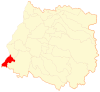
The Maule Region is one of Chile's 16 first order administrative divisions. Its capital is Talca. The region derives its name from the Maule River which, running westward from the Andes, bisects the region and spans a basin of about 20,600 km2. The Maule river is of considerable historic interest because, among other reasons, it marked the southern limits of the Inca Empire.

Parral, Chile City and Commune in Maule, Chile

Parral is a city and commune in the Linares Province of Chile's Maule Region.

Linares, Chile City and Commune in Maule, Chile

Linares is a Chilean city and commune located in the Maule Region and lies in the fertile Chilean Central Valley, 303 km (188 mi) south of Santiago and 50 km (31 mi) south of Talca, the regional capital. Linares is the capital city of the province of Linares.

Talca City and Commune in Talca Province, Maule Region

Talca is a city and commune in Chile located about 255 km (158 mi) south of Santiago, and is the capital of both Talca Province and Maule Region. As of the 2012 census, the city had a population of 201,142.

Roman Catholic Diocese of Linares Catholic ecclesiastical territory

The Roman Catholic Diocese of Linares was established in Linares, Chile, by Pope Pius XI on October 18, 1925, by means of the Bulla Notabiliter Aucto.

Cauquenes City and Commune in Maule, Chile

Cauquenes, a city and commune in Chile, is the capital of the Cauquenes Province and is located in the Maule Region.

San Javier, Chile City and Commune in Maule, Chile

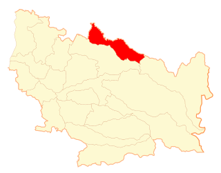
San Javier is a Chilean city and commune located in the Province of Linares, Maule Region. The city lies in the geographical center of the country, some 270 km (168 mi) south of Santiago, 31 km (19 mi) to the northwest of the provincial capital, Linares, and 24 km (15 mi) to the south of Talca, the regional capital. The Pan-American Highway passes through the commune of San Javier, touching tangentially the eastern side of the town. A paved road connects San Javier with Colbún, Colbún dam lake and Panimávida and Quinamávida hot springs.

Villa Alegre, Chile City and Commune in Maule, Chile

Villa Alegre a commune and city located in Linares Province, Maule Region of Chile. With 189.8 km2 (73 sq mi), Villa Alegre is the smallest commune by area in the Maule Region. It sits 92 m (302 ft) above sea level.

Curanipe Place in Maule, Chile

Curanipe is a town and seat of the municipality of Pelluhue, Province of Cauquenes, in VII Maule Region of Chile.

Chanco, Chile Town and Commune in Maule, Chile

Chanco is a Chilean town and commune located in Cauquenes Province, Maule Region.

Cauquenes Province Province in Maule, Chile

Cauquenes Province is one of four provinces of the central Chilean region of Maule (VII). The provincial capital is the city of Cauquenes.

Colbún Town and Commune in Maule, Chile

Colbún is a Chilean town and commune in Linares Province, Maule Region. The commune has a population of over 17,000 inhabitants and covers an area of 2,900 km2 (1,120 sq mi), making it the province's largest. Its capital, the town of Colbún, has 3,679 inhabitants. It is 7 km (4 mi) west of the center of continental Chile.

Yerbas Buenas Town and Commune in Maule, Chile

Yerbas Buenas is a Chilean town and commune in Linares Province, Maule Region. It lies in the geographical center of the country, on the fertile central plain, some 300 km (186 mi) south of the national capital of Santiago, 50 km (31 mi) south of Talca, the regional capital and 12 km (7 mi) north of Linares, the provincial capital.

Longaví City and Commune in Maule, Chile

Longaví is a Chilean city and commune located in Linares Province, one of the four provinces that make up the Maule Region, in the geographical center of Chile.

Retiro, Chile Town and Commune in Maule, Chile

Retiro is a town and commune in Chile, located in Linares Province, in the seventh region of Maule.

Empedrado, Chile Town and Commune in Maule, Chile

Empedrado is a town and commune in the Talca Province of Chile's Maule Region.

Río Claro Commune in Maule, Chile

Río Claro is a commune of the Talca Province in Chile's Maule Region. The municipal seat is the town of Cumpeo. The Claro River valley is an affluent community.

Pelarco Town and Commune in Maule, Chile

Pelarco is a town and commune in Talca Province, Maule Region of Chile. The commune spans an area of 331.5 km2 (128 sq mi).

Maule, Chile Town and Commune in Maule, Chile

Maule is a town and commune in Talca Province in central Chile's Maule Region. It takes its name from the Mapudungun words for "valley" (mau) and "rainy" (len).

Ñiquén Commune in Ñuble, Chile

Ñiquén is a commune of the Punilla Province, located in the north of the Ñuble Region of Chile. Geographically, it is delimited by the Perquilauquén River to the north and the Ñiquén River in the south. Its boundary to the north is the commune of Parral and to the west that of Cauquenes both in the Maule Region, to the south with the commune of San Carlos, and to the east with San Fabian de Alico. The town of San Gregorio is the capital of this commune.

References

  1. 1 2 "Asociación Chilena de Municipalidades" (in Spanish).Missing or empty |url= (help)
  2. 1 2 3 4 5 "National Statistics Institute" (in Spanish). Retrieved 1 September 2010.
  3. "Chile Time". WorldTimeZones.org. Archived from the original on 2010-07-13. Retrieved 2010-09-01.
  4. "Chile Summer Time". WorldTimeZones.org. Archived from the original on 2007-09-11. Retrieved 2010-09-01.
  5. "USGS Earthquake Details". United States Geological Survey . Retrieved February 27, 2010.
  6. Patrick Sawer (February 27, 2010). "Huge earthquake hits Chile". The Daily Telegraph . Retrieved February 27, 2010.