Crescent City, California

Last updated

Crescent City, California
Crescent City California harbor aerial view.jpg
Crescent City harbor
Nickname: 
The Redwood Gate to the Golden State
Del Norte County California Incorporated and Unincorporated areas Crescent City Highlighted 0617022.svg
Location of Crescent City in Del Norte County
Relief map of California.png
Red pog.svg
Crescent City, California
Location in the state of California
Coordinates: 41°45′22″N124°12′06″W / 41.75611°N 124.20167°W / 41.75611; -124.20167
Country United States
State California
County Del Norte
Incorporated April 13, 1854 [1]
Government
  TypeMayor/Council
   Mayor Jason Greenough [2]
   State senator Mike McGuire (D) [3]
   Assemblymember Jim Wood (D) [4]
   U. S. rep. Jared Huffman (D) [5]
Area
[6]
  Total2.42 sq mi (6.25 km2)
  Land1.96 sq mi (5.09 km2)
  Water0.45 sq mi (1.17 km2)  18.7%
Elevation
[7]
43 ft (13 m)
Population
 (2020)
  Total6,673
  Density3,399.39/sq mi (1,312.26/km2)
Time zone UTC-8 (Pacific)
  Summer (DST) UTC-7 (PDT)
ZIP codes
95531, 95532, 95538
Area code 707
FIPS code 06-17022
GNIS feature IDs 277494, 2410262
Website crescentcity.org

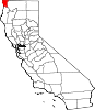
Crescent City is the only incorporated city in Del Norte County, California; it is also the county seat. Named for the crescent-shaped stretch of sandy beach south of the city, Crescent City had a total population of 6,673 in the 2020 census, down from 7,643 in the 2010 census.

Contents

The population includes inmates at Pelican Bay State Prison, also within the city limits, and the former census-designated place Crescent City North annexed to the city.

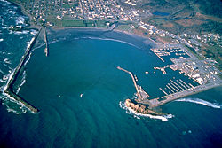
The city is also the site of the Redwood National Park headquarters, as well as the historic Battery Point Light. Due to the richness of the local Pacific Ocean waters and the related catch, and ease of access, Crescent City Harbor serves as home port for numerous commercial fishing vessels.

The city is on the Pacific coast in the upper northwestern part of California, about 20 mi (32 km) south of the Oregon border.

Crescent City's offshore geography makes it unusually susceptible to tsunamis. [8] In 1964 much of the city was destroyed by four tsunami waves generated by the Great Alaskan earthquake off Anchorage, Alaska. In 2011 the city's harbor suffered extensive damage and destruction from tsunamis generated by the March 11, 2011, earthquake off Sendai, Japan. Several dozen vessels and many of the docks they were moored to were destroyed as wave cycles related to the tsunamis exceeded 8 ft (2.4 m).

The climate of Crescent City is moderate, with cool summers for its latitude as a result of intense maritime moderation. Nearby inland areas behind the mountains have substantially warmer summer temperatures.

History

Crescent City was founded on the site of Tolowa Indian Settlements at Battery Point and Pebble Beach south of Point St. George, and north of Point St. George. In Tolowa: Taa-’at-dvn; [9] Yurok: Kohpey; [10] Wiyot: Daluwagh) [11]

In 1855, the U.S. Congress authorized the building of a lighthouse at "the battery point" (a high tide island on the coast of Crescent City) which is still functioning as a historical landmark. [12]

Europeans began moving to the area in the 1850s. Crescent City was incorporated as a city in 1854. [13]

Namesake ships

Shipwrecks

Geography

According to the United States Census Bureau, the city has a total area of 2.415 sq mi (6.25 km2), of which 1.963 sq mi (5.08 km2) (81.3%) is land and 0.452 sq mi (1.17 km2) (18.7%) is water. Fishing and crabbing, tourism, and timber are the major sources of income in Del Norte County. [19] Elk Creek flows into the Pacific Ocean at Crescent City. Its nearest Californian place of any size to its interior is Happy Camp separated by roughly 42 mi (68 km) by air, but, due to the unsuitable terrain, it is much farther by road. The nearest city is fellow coastal city Brookings, Oregon, around 20 mi (32 km) to its north. The Humboldt Bay area encompassing Eureka and Arcata is more than 60 mi (97 km) to its south. Crescent City is as far north in latitude as Chicago, Middle Island in Ontario, Canada, as well as New England on the Atlantic side. It is as much as nine degrees latitude north of San Diego at the southern tip of the state. Crescent City is closer to Vancouver, Canada (838 km (521 mi)) than to Los Angeles (1,003 km (623 mi)). [20]

Brother Jonathan Cemetery in Crescent City BrotherJonathan-Cemetery Crescent City, CA.jpg
Brother Jonathan Cemetery in Crescent City
Crescent City Harbor from Battery Point Lighthouse Crescent City, CA view from BatteryPoint SE.jpg
Crescent City Harbor from Battery Point Lighthouse

Climate

Crescent City has a warm-summer Mediterranean climate (Köppen Csb ). The wettest months are from October to March; the wettest month is December with 11.14 in or 283.0 mm and the driest month is July with 0.33 in or 8.4 mm. The average high and low temperatures in December are 55 °F or 12.8 °C and 41 °F or 5 °C. The average high and low temperatures in August are 64 °F or 17.8 °C and 53 °F or 12 °C. On average, four mornings each winter fall below 32 °F or 0 °C.

The highest temperature recorded in Crescent City was 97 °F (36 °C) on September 20, 1989, and September 21, 1939. The lowest temperature on record was 19 °F (−7 °C) on January 20, 1937, and December 21, 1990. The maximum monthly precipitation was 31.25 in (793.8 mm) in November 1973. The wettest year was 1904 when 107.61 in (2,733.3 mm) fell and the driest year was 2013 with 28.92 in (734.6 mm). The maximum 24-hour precipitation was 7.73 in (196.3 mm) on January 9, 1995. The highest snowfall recorded for any period in 24 hours was 6.0 in (0.15 m) on January 26, 1972. The 30-year average annual precipitation in Crescent City has decreased from 64 inches (1,630 mm) in the 1980–2010 period to about 58 inches (1,470 mm) over the 1990–2020 period. [21]

The warmest ever overnight low was 68 °F (20 °C) in 1929 and the mean between 1991 and 2020 was at the modest 59 °F (15 °C). [21] Cold winter days are also rare. The coldest daytime temperature was 30 °F (−1 °C) in 1924, which remains the last time Crescent City did not climb above the freezing point for 24 hours. [21] Between 1991 and 2020, the coldest maximum temperature averaged 44 °F (7 °C). [21]

Climate data for Crescent City, California (Del Norte County Airport), 1991–2020 normals, extremes 1894–present
MonthJanFebMarAprMayJunJulAugSepOctNovDecYear
Record high °F (°C)75
(24)
78
(26)
88
(31)
86
(30)
89
(32)
91
(33)
96
(36)
95
(35)
97
(36)
93
(34)
80
(27)
80
(27)
97
(36)
Mean maximum °F (°C)65.5
(18.6)
66.2
(19.0)
64.3
(17.9)
65.6
(18.7)
67.8
(19.9)
69.1
(20.6)
69.2
(20.7)
70.7
(21.5)
74.9
(23.8)
76.6
(24.8)
67.6
(19.8)
63.7
(17.6)
80.8
(27.1)
Mean daily maximum °F (°C)56.2
(13.4)
56.2
(13.4)
55.8
(13.2)
57.2
(14.0)
59.3
(15.2)
61.6
(16.4)
63.0
(17.2)
64.2
(17.9)
64.5
(18.1)
62.3
(16.8)
58.2
(14.6)
55.2
(12.9)
59.5
(15.3)
Daily mean °F (°C)49.0
(9.4)
49.3
(9.6)
49.3
(9.6)
50.8
(10.4)
53.3
(11.8)
55.5
(13.1)
57.3
(14.1)
58.5
(14.7)
57.3
(14.1)
54.8
(12.7)
51.1
(10.6)
48.3
(9.1)
52.9
(11.6)
Mean daily minimum °F (°C)41.9
(5.5)
42.4
(5.8)
42.8
(6.0)
44.4
(6.9)
47.2
(8.4)
49.3
(9.6)
51.6
(10.9)
52.8
(11.6)
50.2
(10.1)
47.2
(8.4)
44.0
(6.7)
41.4
(5.2)
46.3
(7.9)
Mean minimum °F (°C)33.1
(0.6)
33.0
(0.6)
34.2
(1.2)
36.1
(2.3)
39.2
(4.0)
42.1
(5.6)
45.3
(7.4)
46.4
(8.0)
43.5
(6.4)
39.0
(3.9)
34.7
(1.5)
32.7
(0.4)
29.9
(−1.2)
Record low °F (°C)19
(−7)
23
(−5)
27
(−3)
29
(−2)
30
(−1)
32
(0)
36
(2)
34
(1)
33
(1)
32
(0)
23
(−5)
19
(−7)
19
(−7)
Average precipitation inches (mm)11.17
(284)
9.84
(250)
9.41
(239)
6.12
(155)
3.48
(88)
1.80
(46)
0.33
(8.4)
0.37
(9.4)
1.40
(36)
5.07
(129)
9.52
(242)
11.74
(298)
70.25
(1,784.8)
Average precipitation days (≥ 0.01 in)17.114.117.614.28.95.62.62.04.09.714.417.0127.2
Source: NOAA [22] [21]

Tsunamis

Battery Point Light, from jetty Battery Point Lighthouse.JPG
Battery Point Light, from jetty
Crescent City's jetty Crescent City Harbor.jpg
Crescent City's jetty

The bathymetry of the sea floor surrounding Crescent City has the effect of focusing tsunamis. According to researchers at Humboldt State University and the University of Southern California, the city experienced tsunami conditions 31 times between the years 1933 and 2008. [23] Although many of these incidents were barely perceptible, eleven events included wave measurements exceeding one meter, four events caused damage, and one event in particular is commonly cited as "the largest and most destructive recorded tsunami to strike the United States Pacific Coast." [24]

On March 27, 1964, the Great Alaskan earthquake off Anchorage, Alaska, set in motion local landslide tsunamis, as well as a trans-Pacific wave. The tsunami wave travel time to Crescent City was 4.1 hours after the earthquake, but it only produced localized flooding. [25] The second and third waves to hit Crescent City were smaller, but the fourth wave struck with a height of approximately 20 ft (6.1 m) after having drawn the harbor out nearly dry. [25] The next morning the damage was counted: 289 buildings and businesses had been destroyed; 1,000 cars and 25 large fishing vessels had been crushed; 12 people were confirmed dead, over 100 were injured, and more were missing; and 60 blocks had been inundated, with 30 city blocks destroyed. Although most of the missing were later accounted for, not all were tracked down. Insurance adjusters estimated that the city received more damage from the tsunami on a block-by-block basis than did Anchorage from the initial earthquake. [26]

The tsunami raced down the West Coast with more deaths and destruction, but no other location was hit as hard. Crescent City bore the brunt, due to its offshore geography, position relative to the earthquake's strike-line, underwater contours such as the Cobb Seamount, and the position of rivers near the city. [27] Although houses, buildings, and infrastructure were later rebuilt, years passed before the city recovered from the devastation to lives, property, and its economy. Since the 1980s, the breakwater has been protected from normal storm waves by hundreds of Dolos armor units, 38 ton concrete shapes. [28]

The city is deemed to be tsunami-ready today. Its preparedness was tested on June 14, 2005, when the 2005 Eureka earthquake measuring 7.2 on the moment magnitude scale hit 90 mi (145 km) offshore; much of the city (an estimated 6,000 people) [29] was evacuated when a tsunami warning was issued, and a 26 cm (10 in) tsunami wave hit the area. [30]

On November 15, 2006, a magnitude 8.3 earthquake struck off Simushir Island in the Kuril Islands in the western Pacific. A tsunami warning was issued but rescinded hours later. However, a surge from that quake did hit the harbor at Crescent City causing damage to three docks and several boats. Governor Arnold Schwarzenegger declared a county state of emergency. Upon that declaration, the area affected was eligible for federal emergency relief funding to repair the damage. [31] [32]

Parts of the city were evacuated on March 11, 2011, after a 9.0 earthquake struck Japan. [33] [34] Thirty-five boats were destroyed, and the harbor suffered major damage. [35] [36] The reported peak surge was over 8 ft (2.4 m) by 9:50am. [37] Five were swept out to sea, and one person was killed. [35] [38] [39]

Demographics

Historical population
CensusPop.Note
1860 638
1870 458−28.2%
1880 343−25.1%
1890 907164.4%
1900 699−22.9%
1910 1,11459.4%
1920 955−14.3%
1930 1,72080.1%
1940 1,363−20.8%
1950 1,70625.2%
1960 2,95873.4%
1970 2,586−12.6%
1980 3,07518.9%
1990 4,38042.4%
2000 4,006−8.5%
2010 7,64390.8%
2020 6,673−12.7%
2023 (est.)5,611 [40] −15.9%
US Decennial Census [41]

2010

The 2010 United States Census [42] reported that Crescent City had a population of 7,643. The population density was 3,164.9/sqmi (1,222.0/km2). The racial makeup of Crescent City was 5,052 (66.1%) White, 910 (11.9%) African American, 370 (4.8%) Native American, 333 (4.4%) Asian, 7 (0.1%) Pacific Islander, 696 (9.1%) from other races, and 275 (3.6%) from two or more races. Hispanic or Latino of any race were 2,342 persons (30.6%).

The Census reported that 4,063 people (53.2% of the population) lived in households, 28 (0.4%) lived in non-institutionalized group quarters, and 3,552 (46.5%) were institutionalized. The very high institutionalized percentage is a result of the presence of Pelican Bay State Prison, which was annexed into the city limits in the 1990s.

There were 1,707 households, out of which 559 (32.7%) had children under the age of 18 living in them, 512 (30.0%) were opposite-sex married couples living together, 314 (18.4%) had a female householder with no husband present, 114 (6.7%) had a male householder with no wife present. There were 170 (10.0%) unmarried opposite-sex partnerships, and 7 (0.4%) same-sex married couples or partnerships. 614 households (36.0%) were made up of individuals, and 229 (13.4%) had someone living alone who was 65 years of age or older. The average household size was 2.38. There were 940 families (55.1% of all households); the average family size was 3.13.

The city population contained 1,107 people (14.5%) under the age of 18, 934 people (12.2%) aged 18 to 24, 3,292 people (43.1%) aged 25 to 44, 1,725 people (22.6%) aged 45 to 64, and 585 people (7.7%) who were 65 years of age or older. The median age was 34.9 years. For every 100 females, there were 250.1 males. For every 100 females age 18 and over, there were 298.5 males.

There were 1,906 housing units at an average density of 789.2/sqmi (304.7/km2), of which 1,707 were occupied, of which 532 (31.2%) were owner-occupied, and 1,175 (68.8%) were occupied by renters. The homeowner vacancy rate was 7.7%; the rental vacancy rate was 4.8%. 1,203 people (15.7% of the population) lived in owner-occupied housing units and 2,860 people (37.4%) lived in rental housing units.

Government

In the California State Legislature, Crescent City is in the 2nd Senate District , represented by Democrat Mike McGuire, [3] and the 2nd Assembly District , represented by Democrat Jim Wood. [4]

In the United States House of Representatives, Crescent City is in California's 2nd congressional district , represented by Democrat Jared Huffman. [5]

Education

The public schools of Crescent City are part of the Del Norte County Unified School District, which encompasses all of the public schools in Del Norte County. The following are schools within Crescent City or its immediate vicinity.

Transportation

Highway access is provided by U.S. Route 101, which runs directly through the city, connecting the Oregon Coast to the north and Eureka to the south. U.S. Route 199 begins north of Crescent City and runs northeast to Grants Pass, Oregon. The junction of U.S. Routes 101 and 199 is one of only two junctions of two U.S. Routes in California, the other being the junction of U.S. Routes 6 and 395 in Bishop.

SkyWest Airlines formerly served Del Norte County Airport (also known as Jack McNamara Field) as United Express until April 7, 2015. Most flights connected to San Francisco International Airport. [44] PenAir contracted to begin serving the airport with Saab 340 turboprop aircraft beginning September 15, 2015. [45]

Contour Airlines currently operates flights from Crescent City (CEC) to Oakland International Airport (OAK) and Los Angeles-Hawthorne Airport (HHR).

Local public transit is provided by Redwood Coast Transit and by various taxi companies. Crescent City is also served by Curry Public Transit, and POINT.

The Crescent City Harbor serves as a commercial fishing port for salmon, shrimp, tuna, cod, and dungeness crab commercial fishing vessels. The Harbor is also home to multiple fishing and non-fishing related businesses and harbor governmental offices. The Crescent City Harbor also has several pleasure boat docks. [46]

Arts and culture

Attractions

Map of the area surrounding Crescent City Redwood-NP Map.png
Map of the area surrounding Crescent City

Annual events

Notable people

International relations

Twin towns – sister cities

Crescent City is twinned with:

See also

Related Research Articles

<span class="mw-page-title-main">Del Norte County, California</span> County in California, United States

Del Norte County is a county located at the far northwest corner of the U.S. state of California, along the Pacific Ocean adjacent to the Oregon border. Its population is 27,743 as of the 2020 census, down from 28,610 from the 2010 census. The county seat and only incorporated city is Crescent City. Del Norte was pioneered and populated by Azorean Portuguese settlers and dairy farmers, which may account for the local pronunciation of the county name. Locals pronounce the county name as Del Nort, not Del Nor-teh as would be expected in Spanish.

<span class="mw-page-title-main">Santa Cruz, California</span> City in California, United States

Santa Cruz is the largest city and the county seat of Santa Cruz County, in Northern California. As of the 2020 census, the city population was 62,956. Situated on the northern edge of Monterey Bay, Santa Cruz is a popular tourist destination, owing to its beaches, surf culture, and historic landmarks.

<span class="mw-page-title-main">Eureka, California</span> City in California, United States

Eureka is a city and the county seat of Humboldt County, located on the North Coast of California. The city is located on U.S. Route 101 on the shores of Humboldt Bay, 270 miles (435 km) north of San Francisco and 100 miles (161 km) south of the Oregon border. At the 2020 census, the population of the city was 26,512. As of the 2010 census, the population of Greater Eureka was 45,034.

<span class="mw-page-title-main">Fort Bragg, California</span> City in California, United States

Fort Bragg is a city along the North Coast of California along in Mendocino County. The city is 24 miles (39 km) west of Willits, at an elevation of 85 feet (26 m). Its population was 6,983 at the 2020 census.

<span class="mw-page-title-main">Brookings, Oregon</span> City in Oregon, United States

Brookings is a city in Curry County, Oregon, United States. It was named after John E. Brookings, president of the Brookings Lumber and Box Company, who founded the city in 1908. As of the 2020 census, the population was 6,744.

<span class="mw-page-title-main">1964 Alaska earthquake</span> Second most powerful earthquake in recorded history

The 1964 Alaskan earthquake, also known as the Great Alaskan earthquake and Good Friday earthquake, occurred at 5:36 PM AKST on Good Friday, March 27, 1964. Across south-central Alaska, ground fissures, collapsing structures, and tsunamis resulting from the earthquake caused about 131 deaths.

<span class="mw-page-title-main">Redwood National and State Parks</span> Group of national and state parks in northwestern California, United States

The Redwood National and State Parks (RNSP) are a complex of one national park and three California state parks located in the United States along the coast of northern California. The combined RNSP contain Redwood National Park, Del Norte Coast Redwoods State Park, Jedediah Smith Redwoods State Park, and Prairie Creek Redwoods State Park. The parks' 139,000 acres (560 km2) preserve 45 percent of all remaining old-growth coast redwood forests.

<span class="mw-page-title-main">Smith River (California)</span> River in California, United States

The Smith River flows from the Klamath Mountains to the Pacific Ocean in Del Norte County in extreme northwestern California, on the West Coast of the United States. The river, about 25.1 miles (40.4 km) long, all within Del Norte County, flows through the Rogue River – Siskiyou National Forest, Six Rivers National Forest, and Jedediah Smith Redwoods State Park.

The Tolowa language is a member of the Pacific Coast subgroup of the Athabaskan language family. Together with three other closely related languages it forms a distinctive Oregon Athabaskan cluster within the subgroup.

The Tolowa people or Taa-laa-wa Dee-ni’ are a Native American people of the Athabaskan-speaking ethno-linguistic group. Two rancherías still reside in their traditional territory in northwestern California. Those removed to the Siletz Reservation in Oregon are located there.

<span class="mw-page-title-main">North Coast (California)</span> Region of California, United States

The North Coast of California is a region in Northern California that lies on the Pacific coast between San Francisco Bay and the Oregon border. It commonly includes Mendocino, Humboldt, and Del Norte counties and sometimes includes Lake and two counties from the San Francisco Bay area, Marin and Sonoma.

<span class="mw-page-title-main">Battery Point Light</span> Lighthouse in California, United States

Battery Point Light is a lighthouse in Crescent City, California, United States. It is registered as a California Historical Landmark, and is listed on the National Register of Historic Places as "Crescent City Lighthouse".

The 2006 Kuril Islands earthquake occurred on November 15 at 8:14:16 pm JST with a Mw magnitude of 8.3 and a maximum Mercalli intensity of IV (Light) and a maximum Shindo intensity of JMA 2. This megathrust earthquake was the largest event in the central Kuril Islands since 1915 and generated a small tsunami that affected the northern Japanese coast. The tsunami crossed the Pacific Ocean and damaged the harbor at Crescent City, California. Post-tsunami surveys indicate that the local tsunami in the central Kuril Islands reached runups of 21.9 metres (72 ft) or higher.

<span class="mw-page-title-main">Gasquet, California</span> Census-designated place in California, United States

Gasquet is an unincorporated community in Del Norte County, California, United States, 22 mi (35 km) south of the Oregon border and 18 miles (29 km) northeast of Crescent City. The name is in honor of Horace Gasquet, who was the owner of the gold mines, hotel, railway, bank and post office, as well as the founder of Crescent City and Happy Camp. A post office operated at Gasquet from 1879 to 1902 and from 1949 to present. Gasquet is located in the Smith River National Recreation Area.

<span class="mw-page-title-main">Tolowa Dunes State Park</span> State Park in Del Norte County, California

Tolowa Dunes State Park is a 4,000-acre (16 km2) California State Park located in Del Norte County, on the North Coast of California.

<span class="mw-page-title-main">Fort Dick, California</span> Unincorporated community in California, United States

Fort Dick is a small unincorporated community and census-designated place (CDP) in rural Del Norte County, California. Fort Dick is around five miles north of Crescent City, California, and around 15 mi (24 km) south of the California–Oregon state line. Its population is 912 as of the 2020 census, up from 588 from the 2010 census. It is located on the U.S. Route 101 corridor on the Redwood Coast. A post office was set up in 1917.

<span class="mw-page-title-main">Teletsunami</span> Massive tsunamis that strike a thousand kilometers or more from their source

A teletsunami is a tsunami that originates from a distant source, defined as more than 1,000 km (620 mi) away or three hours' travel from the area of interest, sometimes travelling across an ocean. All teletsunamis have been generated by major earthquakes such as the 1755 Lisbon earthquake, 1960 Valdivia earthquake, 1964 Alaska earthquake, 2004 Indian Ocean earthquake, 2011 Tohoku earthquake, and the 2021 South Sandwich Islands earthquakes.

<span class="mw-page-title-main">2010 Chile earthquake</span> Magnitude 8.8 earthquake in Chile on 27 February 2010

The 2010 Chile earthquake and tsunami occurred off the coast of central Chile on Saturday, 27 February at 03:34:12 local time, having a magnitude of 8.8 on the moment magnitude scale, with intense shaking lasting for about three minutes. It was felt strongly in six Chilean regions that together make up about 80 percent of the country's population. According to the United States Geological Survey (USGS) the cities experiencing the strongest shaking—VIII (Severe) on the Mercalli intensity scale (MM)—were Concepción, Arauco, and Coronel. According to Chile's Seismological Service, Concepción experienced the strongest shaking at MM IX (Violent). The earthquake was felt in the capital Santiago at MM VII or MM VIII. Tremors were felt in many Argentine cities, including Buenos Aires, Córdoba, Mendoza, and La Rioja. Tremors were felt as far north as the city of Ica in southern Peru. It is the largest earthquake to hit Chile since the 1960 Valdivia earthquake.

<span class="mw-page-title-main">2011 Tōhoku earthquake and tsunami</span> Megathrust earthquake off Japans east coast

On 11 March 2011, at 14:46 JST, a Mw 9.0–9.1 undersea megathrust earthquake occurred in the Pacific Ocean, 72 km (45 mi) east of the Oshika Peninsula of the Tōhoku region. It lasted approximately six minutes and caused a tsunami. It is sometimes known in Japan as the "Great East Japan Earthquake", among other names. The disaster is often referred to by its numerical date, 3.11.

The Tolowa Dee-ni' Nation, previously known as Smith River Rancheria, is a federally recognized tribe of Tolowa people in Del Norte County, California. They are Athabascan people, distantly related to northern Athabascans of eastern Alaska and western Canada, as well as the Apache and Navajo peoples of the American Southwest.

References

  1. "California Cities by Incorporation Date". California Association of Local Agency Formation Commissions. Archived from the original (Word) on November 3, 2014. Retrieved April 5, 2013.
  2. "City Council". Crescent City, California. Archived from the original on April 15, 2021. Retrieved February 4, 2021.
  3. 1 2 "Senators". State of California. Archived from the original on April 24, 2013. Retrieved April 1, 2013.
  4. 1 2 "Assembly Members". State of California. Archived from the original on April 24, 2013. Retrieved April 1, 2013.
  5. 1 2 "California's 2nd Congressional District - Representatives & District Map". Civic Impulse, LLC. Retrieved April 1, 2013.
  6. "2020 U.S. Gazetteer Files". United States Census Bureau. Retrieved October 30, 2021.
  7. "Crescent City". Geographic Names Information System . United States Geological Survey, United States Department of the Interior.
  8. McKinley, Jesse (March 16, 2011). "Sleepy California Town, and a Tsunami Magnet". The New York Times . Archived from the original on March 20, 2011. Retrieved March 17, 2011. Crescent City has long been known as one of the nation's most susceptible spots when it comes to tsunamis, something that experts say is a result of a number of factors
  9. "Siletz Talking Dictionary". Archived from the original on October 5, 2013. Retrieved June 4, 2012.
  10. "Yurok Dictionary: Kohpey". Archived from the original on May 8, 2013. Retrieved July 7, 2012.
  11. "Language; Wiyot Tribe". Archived from the original on February 13, 2012. Retrieved July 7, 2012.
  12. "Battery Point, Crescent City CA". Lighthouses of the United States. Lighthouse Friends. 2013. Archived from the original on February 5, 2012. Retrieved February 10, 2013.
  13. "Crescent City People and Place" (PDF). Community Profiles. National Oceanic and Atmospheres Administration. 2007. Archived from the original (PDF) on May 28, 2010. Retrieved February 10, 2013.
  14. Gleason, Hall (1937). Old Ships and Ship-Building Days of Medford. Medford MA: J.C. Miller. p. 71.
  15. Crescent City Archived June 11, 2011, at the Wayback Machine , Puget Sound Maritime Historical Society Images, University of Washington Libraries
  16. "Crescent City, CINMS Shipwreck Database". NOAA / National Marine Sanctuaries. Archived from the original on November 7, 2011. Retrieved May 23, 2010.
  17. Powers, Dennis (2006). Treasure Ship: The Legend and Legacy of the S.S. Brother Jonathan. New York NY: Kensington/Citadel Press.
  18. Webber, Ebbert (1975). Retaliation: Japanese Attacks and Allied Countermeasures on the Pacific Coast in World War II. Oregon State University Press. ISBN   978-0-87071-076-6.
  19. Smith, Christopher (July 1, 2012). "Del Norte County piers". Los Angeles Times . Archived from the original on June 24, 2016. Retrieved May 23, 2016.
  20. "Distance by Latitude/Longitude" (accessed/calculated 18 October 2019)
  21. 1 2 3 4 5 "Summary of Monthly Normals 1991–2020". National Oceanic and Atmospheric Administration . Retrieved June 12, 2021.
  22. "NOWData – NOAA Online Weather Data". National Oceanic and Atmospheric Administration . Retrieved June 12, 2021.
  23. Dengler, Lori; B. Uslu; A. Barberopoulou; J. Borrero; C. Synolakis (September–October 2008). "The Vulnerability of Crescent City CA to Tsunamis Generated by Earthquakes in the Kuril Islands Region of the Northwestern Pacific". Seismological Research Letters. 79 (5): 608–619. doi:10.1785/gssrl.79.5.608.
  24. "1964 Alaskan Tsunami". USC Tsunami Research Group. University of Southern California. Archived from the original on January 8, 2013. Retrieved February 11, 2013.
  25. 1 2 Pararas-Carayannis, George (2007). "The Effects of the March 27, 1964 Alaska Tsunami In California". The Tsunami Page. Archived from the original on November 27, 2012. Retrieved February 11, 2013.
  26. Dennis M. Powers (January 1, 2005). The Raging Sea: The Powerful Account of the Worst Tsunami in U.S. History. Citadel Press. pp. 4–. ISBN   978-0-8065-2682-9.
  27. Silverman, Billy (March 14, 2011). "Crescent City Tsunami Is 34th Since 1934". Huffington Post Los Angeles. Archived from the original on October 21, 2013. Retrieved October 4, 2013.
  28. "Archived copy". Archived from the original on December 22, 2015. Retrieved May 12, 2015.{{cite web}}: CS1 maint: archived copy as title (link)
  29. "7.0 quake shakes up North Coast / Crescent City residents flee after tsunami warning". sfgate.com. June 15, 2005. Archived from the original on June 2, 2016. Retrieved April 29, 2018.
  30. Archived December 14, 2009, at the Wayback Machine
  31. Crescent City Suffers Damage from November 15, 2006 Kuril Island Earthquake and Tsunami Archived October 4, 2013, at the Wayback Machine , California Department of Transportation
  32. Uslu, Burak; Borrero, Jose C.; Dengler, Lori; Synolakis, Costas E.; Barberopoulou, Aggeliki (2008). "Tsunami Inundation from Great Earthquakes on the Cascadia Subduction Zone along the Northern California Coast". Solutions to Coastal Disasters 2008. pp. 204–214. doi:10.1061/40978(313)19. ISBN   978-0-7844-0978-7.
  33. Tam, Donna, Tsunami takes toll on North Coast; hundreds evacuated, Gov. Brown declares state of emergency Archived July 17, 2011, at the Wayback Machine , Eureka Times-Standard, March 12, 2011
  34. Evert, Barry,Pelican Bay Sgt. describes response to Tsunami Archived March 16, 2011, at the Wayback Machine , March 11, 2011, accessed October 4, 2013
  35. 1 2 Johnson, C. (March 3, 2011). "Tsunami sweeps 5 to sea, rips out California docks". KXTV . Archived from the original on March 11, 2011. Retrieved March 11, 2011.
  36. Waves destroy Crescent City Harbor docks Archived March 11, 2011, at the Wayback Machine , Eureka Times-Standard, March 11, 2011
  37. Great Japan quake generates 8-foot tsunami in California Archived October 14, 2013, at the Wayback Machine , Dr. Jeff Masters' WunderBlog, accessed October 4, 2013
  38. "Five swept out to sea, 1 killed as tsunami hits Crescent City CA". International Business Times. March 11, 2011. Archived from the original on July 17, 2012.
  39. Anton, Mike; Li, Shan (March 11, 2011). "Crescent City harbor destroyed; 4 people swept into sea, 1 feared dead". Los Angeles Times.
  40. "City and Town Population Totals: 2020-2023". United States Census Bureau. May 16, 2024. Retrieved May 16, 2024.
  41. "2020 US Census – Crescent City, California". United States Census Bureau. Retrieved June 19, 2021.
  42. "2010 Census Interactive Population Search: CA – Crescent City city". US Census Bureau. Archived from the original on January 18, 2016. Retrieved July 12, 2014.
  43. "Sunset High School Infant-toddler Center – CRESCENT CITY CA DAY CARE CENTER". childcarecenter.us. Archived from the original on July 28, 2012. Retrieved April 29, 2018.
  44. "UNITED Ends San Francisco – Crescent City Service from April 2015". Archived from the original on December 18, 2014. Retrieved December 17, 2014.
  45. "Fly Crescent City Airlines and Flights". Archived from the original on June 26, 2015. Retrieved June 4, 2015.
  46. Kabir, Shanila (August 18, 2021). "RV Residents in Crescent City Believe They are Being Wrongfully Evicted During Harbor Project". KIEM-TV | Redwood News. Retrieved August 18, 2021.
  47. Jensen, Derrick (2006). Endgame, Volume 1: The Problem of Civilization. Seven Stories Press. p. 17. ISBN   978-1-58322-730-5.
  48. Richard, Terry (August 14, 2015). "Wendell Wood, 65, remembered as protector of environment". The Oregonian . Archived from the original on August 24, 2015. Retrieved September 3, 2015.
  49. "Sister Cities International Member Crescent City/Del Norte County, California to be Featured During NBC Olympic Coverage". Sister Cities International . July 23, 2021. Retrieved August 8, 2021.
  50. "January 7, 2019 Council Agenda" (PDF). City of Crescent City. January 7, 2019. Retrieved August 8, 2021.