Teresa Salas, a Californio socialite, was a figure in early Sonora society.
Sonora was founded by Mexican miners during the California gold rush. Sonorans were alongside Chileans among the most experienced miners in the rush.[8] Named after their home state of Sonora, Mexico, it was once a booming center of industry and trade in California's Mother Lode. Most of the gold removable with traditional mining techniques was quickly extracted, leaving miners to use more complex and expensive mining techniques to reach deep pockets of quartz and gold. Sonora as well as other mining towns of the era experienced economic hardship when the value of gold decreased. As "gold fever" died down, Sonora's size and population steadily decreased over the years.[1] In c.1851, the Sonora Hebrew Cemetery was formed by the Hebrew Benevolent Society and predominantly contains the graves of European-born Jews who emigrated to Gold Country.[9][10]
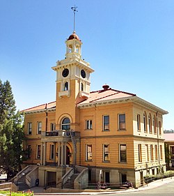
The Tuolumne County Museum and History Center preserves the town's Gold Rush legacy.
Sonora is located around the intersection of California State Highways 49 and 108 The altitude is 1,825 feet (556m). According to the United States Census Bureau, the city covers a total area of 3.2 square miles (8.3km2), making it the county's largest community by land area. 99.57% of the area is land and 0.43% of it is water.[3]
Climate
There are an average of 75 days annually with highs of 90°F (32.2°C) or higher and an average of 65.5 days annually with lows of 32°F (0°C) or lower. The record high temperature was 113°F (45°C) on June 22, 1961, and July 15, 1972. The record low temperature was 8°F (−13.3°C) on December 9, 1972.[11]
Average annual rainfall is 32.79 inches (832.9mm), almost all from November through April, although there are occasionally afternoon and evening thunderstorms in the summer months, which drift down from the Sierra Nevada. There are an average of 63.8 days annually with measurable precipitation. The wettest "rain year" has been from July 1982 to June 1983 with 60.29 inches (1,531.4mm) and the driest from July 1975 to June 1976 with 15.26 inches (387.6mm).[12] The most rainfall in one month was 21.69 inches (550.9mm) in December 1955, including 7.1 inches (180.3mm) on December 27, the record 24-hour rainfall. The most snowfall in one month was 30.5 inches (77.5cm) in January 1933.[13] The Köppen Climate Classification subtype for this climate is Csa (hot-summer Mediterranean climate).[14]
Climate data for Sonora, California, 1991–2020 normals, extremes 1906–present
The census reported that 97.8% of the population lived in households, 0.7% lived in non-institutionalized group quarters, and 1.5% were institutionalized.[32]
There were 2,301 households, out of which 26.8% included children under the age of 18, 30.2% were married-couple households, 9.4% were cohabiting couple households, 38.0% had a female householder with no partner present, and 22.3% had a male householder with no partner present. 39.1% of households were one person, and 16.7% were one person aged 65 or older. The average household size was 2.13.[32] There were 1,163 families (50.5% of all households).[33]
The age distribution was 18.8% under the age of 18, 8.4% aged 18 to 24, 26.9% aged 25 to 44, 24.1% aged 45 to 64, and 21.7% who were 65years of age or older. The median age was 41.4years. For every 100 females, there were 87.6 males.[32]
There were 2,515 housing units at an average density of 795.1 unitsper square mile (307.0 units/km2), of which 2,301 (91.5%) were occupied. Of these, 42.0% were owner-occupied, and 58.0% were occupied by renters.[32]
In 2023, the US Census Bureau estimated that the median household income was $62,621, and the per capita income was $39,503. About 17.4% of families and 20.0% of the population were below the poverty line.[34]
2010
St. James Episcopal Church
At the 2010 census Sonora had a population of 4,903. The population density was 1,593.0 inhabitants per square mile (615.1/km2). The racial makeup of Sonora was 4,402 (89.8%) White, 24 (0.5%) African American, 95 (1.9%) Native American, 79 (1.6%) Asian, 12 (0.2%) Pacific Islander, 84 (1.7%) from other races, and 207 (4.2%) from two or more races. Hispanic or Latino of any race were 542 people (11.1%).[35]
The census reported that 4,613 people (94.1% of the population) lived in households, 85 (1.7%) lived in non-institutionalized group quarters, and 205 (4.2%) were institutionalized.
There were 2,199 households, 562 (25.6%) had children under the age of 18 living in them, 689 (31.3%) were opposite-sex married couples living together, 308 (14.0%) had a female householder with no husband present, 116 (5.3%) had a male householder with no wife present. There were 192 (8.7%) unmarried opposite-sex partnerships, and 12 (0.5%) same-sex married couples or partnerships. 881 households (40.1%) were one person and 312 (14.2%) had someone living alone who was 65 or older. The average household size was 2.10. There were 1,113 families (50.6% of households); the average family size was 2.77.
The age distribution was 975 people (19.9%) under the age of 18, 526 people (10.7%) aged 18 to 24, 1,266 people (25.8%) aged 25 to 44, 1,324 people (27.0%) aged 45 to 64, and 812 people (16.6%) who were 65 or older. The median age was 39.7 years. For every 100 females, there were 93.0 males. For every 100 females age 18 and over, there were 89.9 males.
There were 2,463 housing units at an average density of 800.2 per square mile; of the occupied units, 898 (40.8%) were owner-occupied and 1,301 (59.2%) were rented. The homeowner vacancy rate was 4.6%; the rental vacancy rate was 8.6%. 1,960 people (40.0% of the population) lived in owner-occupied housing units and 2,653 people (54.1%) lived in rental housing units.
Economy and tourism
The historic Mission Revival–style Sonora Inn, built in 1896
The area economy was historically based on the mining and timber industries, but now relies on tourism.[36] One of two active lumber mills in Tuolumne County was shut down in 2009, but reopened in July 2011.[37]
The city's schools include its namesake educational institutions Sonora Union High School[38] and Sonora Elementary School,[39] as well as Dario Cassina High[40] and the Foothill Horizons Outdoor School.
Sonora uses a city council consisting of five council members, including the mayor. The city council appoints a city administrator to implement the council's policies and enforce ordinances. As of June 2024, the current mayor of Sonora is Ann Segerstrom and the current city administrator is Melissa Eads.[41][42]
The Tuolumne County Film Commission describes Sonora as "one of the country's most versatile locations", where more than "300 film[s] and television series" have been made.[48]
Local museums depict the Gold Rush era and historic Sonora.
The small town is home to the professional theatre company Sierra Repertory Theatre, which produces a variety of musicals and plays each year at two different theatre buildings: the East Sonora Theatre, and the Fallon House Theatre in Columbia.[49]
Sonora is also home to the Tuolumne County Arts Alliance.[50]
David Carkeet's 2005 memoir, Campus Sexpot, describes his and the Sonora community's reaction to Dale Koby's early 1960s cult/underground novel, also titled Campus Sexpot, and its thinly-veiled description of the town, fictionalized as "Wattsville".[52]
↑Levinson, Robert E. (1994). The Jews in the California Gold Rush. Commission for the Preservation of Pioneer Jewish Cemeteries and Landmarks, Judah L. Magnes Museum. ISBN978-0943376622.
This page is based on this Wikipedia article Text is available under the CC BY-SA 4.0 license; additional terms may apply. Images, videos and audio are available under their respective licenses.