Owens River

Last updated
Owens River
Wakopee [1] [2]
Owens Valley Sh-p6250166.jpg
Owens River south of Poverty Hills
Owensmap-01.png
Map of the Owens Lake watershed, including Los Angeles Aqueduct system
Relief map of California.png
Red pog.svg
Location of the mouth of the Owens River in California
Location
Country United States
State California
District Mono County, Inyo County
Cities Mesa, Bishop, Big Pine, Elna (site), Chrysopolis (site), Independence, Lone Pine
Physical characteristics
SourceConfluence of Deadman Creek and an unnamed stream
  location Inyo National Forest, Mono County
  coordinates 37°45′01″N118°56′20″W / 37.75028°N 118.93889°W / 37.75028; -118.93889 [2]
  elevation7,251 ft (2,210 m)
Mouth Owens Lake
  location
A few miles northwest of Keeler, Inyo County
  coordinates
36°32′31″N117°58′45″W / 36.54194°N 117.97917°W / 36.54194; -117.97917 Coordinates: 36°32′31″N117°58′45″W / 36.54194°N 117.97917°W / 36.54194; -117.97917 [2]
  elevation
3,592 ft (1,095 m)
Length183 mi (295 km), north-south
Basin size2,604 sq mi (6,740 km2)
Discharge 
  location Big Pine, CA [3]
  average389 cu ft/s (11.0 m3/s) [3]
  minimum51.9 cu ft/s (1.47 m3/s)
  maximum3,220 cu ft/s (91 m3/s)
Basin features
Tributaries 
  leftSpring Valley Wash, Silver Canyon Creek, Coldwater Canyon Creek
  right Hot Creek, Rock Creek, Bishop Creek, Big Pine Creek, Birch Creek, Independence Creek, Lone Pine Creek

The Owens River is a river in eastern California in the United States, approximately 183 miles (295 km) long. [4] It drains into and through the Owens Valley, an arid basin between the eastern slope of the Sierra Nevada and the western faces of the Inyo and White Mountains. The river terminates at the endorheic Owens Lake south of Lone Pine, at the bottom of a 2,600 sq mi (6,700 km2) watershed.

Contents

In the early 1900s, the Owens River was the focus of the California Water Wars, fought between the city of Los Angeles and the inhabitants of Owens Valley over the construction of the Los Angeles Aqueduct. Since 1913, the Owens River has been diverted to Los Angeles, causing the ruin of the valley's economy and the drying of Owens Lake. In winter 2006, the Los Angeles Department of Water and Power restored 5% of the pre-aqueduct flow to the river by court order, allowing the Owens River Gorge, the river bed in the valley, and Owens Lake to contain a small amount of water. [5]

Course

The river rises in the Sierra Nevada in southwestern Mono County, approximately 15 miles (24.1 km) south of Mono Lake and 35 miles (56.3 km) east of Yosemite Valley. It flows southeast across the Long Valley Caldera, through Lake Crowley reservoir, then descends through the 20-mile-long (32 km) Owens River Gorge, emerging at the north end of the Owens Valley northwest of Bishop. In the area around Bishop, it is diverted through many ditches to irrigate the surrounding farming region. It flows south-southeast through the Owens Valley between the Sierra Nevada on the west and the White and Inyo Mountains on the east, past Big Pine. Approximately 14 miles (22.5 km) south-southeast of Big Pine, most of the remaining river is diverted into the Los Angeles Aqueduct, completed in 1913 to supply municipal, recreational and agricultural water to Los Angeles. The remaining river flows through the southern valley, flanked by the Los Angeles Aqueduct, past Lone Pine, entering the lake bed of predominantly dry Owens Lake at the southern end of Owens Valley. [6] [7]

Watershed

The river flows through two major valleys of the extreme southwestern Great Basin – the Long Valley and Owens Valley. [8] The north to south drainage basin is in portions of Mono and Inyo counties and terminates in the now-dry Owens Lake. [9] To the northwest of the valley is the Long Valley Caldera, which is only a fraction of the size of the Owens Valley. The Owens River enters Owens Valley from the northwest, while the Spring Valley Wash drains the northernmost part of the valley, extending a tiny portion of the basin into Nevada. [7] The river flows mainly on the east side of the valley, because alluvial deposits from Sierra Nevada streams have forced the river channel in that direction. [9]

Vertical relief in the basin is immense – elevations range from 14,505 feet (4,421 m) at Mount Whitney, the highest peak in the continental United States, [9] [10] [11] to 3,556 feet (1,084 m) on the bed of Owens Lake. [12] The Owens River itself heads at an elevation of 7,291 feet (2,222 m). Few people inhabit the sparse, open grasslands and steep mountainsides of the watershed; the 2009 population of Mono County was about 12,927 [13] while Inyo County had some 17,293 inhabitants. [14] The largest city on the river is Bishop, with a population of just under 4,000. Other significant towns include Lone Pine (population 2,035), Big Pine (population 1,707), and Independence (population 669).

Geology

The Owens River flows through part of the Basin and Range Province of North America's Great Basin. The Owens Valley is a graben or rift valley, a section of land that has dropped down between two parallel faults, while the land on either side has risen. This has resulted in the flat floor and steep, towering walls of the present-day valley. [15] With the Sierra Nevada on the west side and the Inyo Mountains and White Mountains on the east, with the highest peaks of either range rising to over 14,000 feet (4,300 m) and the floor of the valley at a comparatively low 3,000 to 4,000 feet (910 to 1,220 m), the Owens River flows in one of the deepest valleys in the United States. [15] [16]

Further to the north, the Owens River basin encompasses predominantly igneous rocks and vast remnants of past volcanic activity. The upper 30 miles (48 km) of the river run through the Long Valley Caldera, an enormous 20-mile (32 km)-wide crater formed by a volcanic eruption some 760,000 years ago. [17] The eruption's resulting ash cloud covered much of the southwestern United States, including parts of ten U.S. states. [18] Mammoth Mountain, to the southwest (more popularly known as a major ski area) also formed from eruptions related to the Long Valley Caldera. [11] To the north of the Caldera, extending to the Mono Lake area, lie the chain of Mono-Inyo Craters, which range in age from 400,000 to 500 years old. [19]

During the Pleistocene at the end of the last glacial period, melting glaciers in the Sierra Nevada and Inyo/White Mountains fed prodigious amounts of runoff into the Owens River, causing it to expand to many times its current size. The increased river volume caused Owens Lake to rise as well, eventually spilling out the south side of the valley into the Mojave Desert. Ancient, now-abandoned river channels suggest that the extended Owens River ran south to China Lake, then east into Searles Lake, north into the Panamint Valley (where it formed Panamint Lake), and finally east into Death Valley and the ancient Lake Manly. This great inland sea was also fed by the Mojave River from the south, the Amargosa River from the east, and the Death Valley Wash from the north. [20] During this relatively short time, the Owens River became part of a vast interior drainage system that stretched east to west, covering over 8,000 square miles (21,000 km2). During the runoff peak, water from this massive basin may have escaped to the Colorado River through a valley leading to the southeast. [21]

History

The semi-arid Owens Valley, with the Owens River flowing through the foreground Owens River from tableland-750px.jpg
The semi-arid Owens Valley, with the Owens River flowing through the foreground

For thousands of years the Owens River valley was inhabited by the seminomadic Owens Valley Northern Paiute and the Shoshone tribes of Native Americans. The indigenous name for the river was Wakopee, while they called Owens Lake Pacheta. [22] In the upper Owens Valley lie traces of some of California's first irrigation systems, created by Paiute groups to water small patches of crops. It is believed that native people in the upper portion of the valley once built dams across the Owens River (and possibly one of its major tributaries, Bishop Creek) to divert water into local canals. The switch from a hunter-gatherer to a settled, agricultural lifestyle is probably the result of the climate of the Owens Valley becoming drier some 1,000 years ago. [23]

Typically, the Native Americans built dams across the river or other tributary streams in the spring out of materials including boulders, dirt, reeds, grass, or other elements. The watercourse below the dam would then be desiccated, and the water led by canal to the irrigated plot of land, typically no more than a few square miles. [24] [25] Directly after the dam was closed and the river dried up, fish trapped on the dry riverbed would then be gathered and eaten. Before winter storms caused floods, the dam would be breached, allowing the river to flow naturally again, while fish would be collected in the dried-up river channel. [26] By then, there would be enough food stored to last the winter in which the cropland would lie fallow. [24] [27]

In the nineteenth century, the Owens River was first seen by American explorers. One of the first explorers was John C. Fremont, who led a cartographic expedition to the Owens Valley in 1845. His party included Kit Carson, Edward Kern, and Richard Owens, the latter for whom the river, lake, and valley are named. Other well-known adventurers included Jedediah Smith and Joseph R. Walker, who also came into the area in the 1800s. [22] Gradually, the river's surroundings were settled by farmers and ranchers. [28] The valley never accumulated a very large population, but mining activities brought significant income to the new inhabitants of the area. [22] Ore was shipped down the Owens River from the north, and also borax and silver from Death Valley to the east. Until 1924, Owens Lake was still so large that a steamboat ferry operated between its east and west sides, ferrying freight and passengers across in three hours, much less than the three days required to semi-circumnavigate the lake. [29] In 1872, the Lone Pine earthquake killed 27 people in the Owens Valley, mostly in Lone Pine.

Ecology

Beaver was re-introduced to the Owens Valley by the California Department of Fish and Game in 1948 in Baker Creek, [30] and has since spread throughout the Owens Valley. [31] Although it is controversial whether beaver were once native to the Owens Valley, there is growing evidence that they were native to the eastern slope of the Sierra Nevada. In particular, the northern Paiute of Walker Lake, Honey Lake and Pyramid Lake have a word for beaver su-i'-tu-ti-kut'-teh. [32] When Stephen Powers visited the northern Paiute to collect Indian materials for the Smithsonian Institution in preparation for the Centennial Exhibition of 1876, he reported that the northern Paiute wrapped their hair in strips of beaver fur, made medicine from parts of beaver and that their creation legend included beaver. [32] In addition, fur trapper Stephen Hall Meek "set his traps on the Truckee River in 1833", which strongly suggests that he saw a beaver or beaver sign. [33] Supporting this line of evidence, Tappe records in 1941 an eyewitness who said beaver were plentiful on the upper part of the Carson River and its tributaries in Alpine County until 1892 when they fell victim to heavy trapping. [34]

In 2011, the Los Angeles Department of Water and Power (LADWP) decided to trap beaver (Castor canadensis) out of the Owens Valley, claiming that beaver are damming flows into their diversions of water to Los Angeles. [35] This decision runs counter to an independent assessment commissioned by LADWP and the Inyo County Water Department in 1997, where it was recommended that beaver be maintained in reasonable populations and their dams left in place because "Although beaver activity has resulted in the removal of much willow and other shrub and woody vegetation and the dams create favorable tule conditions and reduce fish spawning habitat, they also provide important fish rearing habitat, mesic meadows, and promote the growth of other riparian species. It is most likely that the physical removal of beaver dams will result in more adverse environmental impacts than environmental benefits." [36]

Water rights controversy

The acquisition of water rights for the Los Angeles Aqueduct under the direction of William Mulholland was highly controversial and led to violence and sabotage by local residents in the 1920s. [37] [38] The diversion of water and the subsequent desiccation of Owens Lake remains highly controversial, and the restoration of the lake has been a long-time goal of the California environmentalist community. [39] [40] The lower Owens River and Owens Lake were left dry by the 1913 diversions, until lawsuits forced LADWP to start releasing water into the 62 mi (100 km) lower Owens River in December 2006. [41] In less than one year, the lower Owens River was teeming with fish, birds and other wildlife. [42]

SierraEscarpmentCA.jpg
Panorama of the Owens River Valley from the Inyo Mountains. The large body of water is the Tinemaha Reservoir.

See also

Related Research Articles

Long Valley Caldera Geologic depression near Mammoth Mountain, California, United States

Long Valley Caldera is a depression in eastern California that is adjacent to Mammoth Mountain. The valley is one of the Earth's largest calderas, measuring about 20 mi (32 km) long (east-west), 11 mi (18 km) wide (north-south), and up to 3,000 ft (910 m) deep.

<span class="mw-page-title-main">Inyo County, California</span> County in California, United States

Inyo County is a county in the eastern central part of the U.S. state of California, located between the Sierra Nevada and the state of Nevada. In the 2020 census, the population was 19,016. The county seat is Independence. Inyo County is on the east side of the Sierra Nevada and southeast of Yosemite National Park in Central California. It contains the Owens River Valley; it is flanked to the west by the Sierra Nevada and to the east by the White Mountains and the Inyo Mountains. With an area of 10,192 square miles (26,397 km2), Inyo County is the second-largest county by area in California, after San Bernardino County. Almost one-half of that area is within Death Valley National Park. However, with a population density of 1.8 people per square mile, it also has the second-lowest population density in California, after Alpine County.

<span class="mw-page-title-main">Mount Whitney</span> Highest mountain in California, United States

Mount Whitney is the highest mountain in the contiguous United States and the Sierra Nevada, with an elevation of 14,505 feet (4,421 m). It is in East–Central California, on the boundary between California's Inyo and Tulare counties, 84.6 miles (136.2 km) west-northwest of North America's lowest point, Badwater Basin in Death Valley National Park, at 282 ft (86 m) below sea level. The mountain's west slope is in Sequoia National Park and the summit is the southern terminus of the John Muir Trail, which runs 211.9 mi (341.0 km) from Happy Isles in Yosemite Valley. The eastern slopes are in Inyo National Forest in Inyo County.

<span class="mw-page-title-main">Owens Valley</span> Valley in California, United States

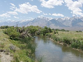
Owens Valley is an arid valley of the Owens River in eastern California in the United States. It is located to the east of the Sierra Nevada, west of the White Mountains and Inyo Mountains, and north of the Mojave Desert. It sits on the west edge of the Great Basin. The mountain peaks on the West side reach above 14,000 feet (4,300 m) in elevation, while the floor of the Owens Valley is about 4,000 feet (1,200 m), making the valley the deepest in the United States. The Sierra Nevada casts the valley in a rain shadow, which makes Owens Valley "the Land of Little Rain." The bed of Owens Lake, now a predominantly dry endorheic alkali flat, sits on the southern end of the valley.

Owens Lake Dried-out lake in the Owens Valley, California

Owens Lake is a mostly dry lake in the Owens Valley on the eastern side of the Sierra Nevada in Inyo County, California. It is about 5 miles (8.0 km) south of Lone Pine, California. Unlike most dry lakes in the Basin and Range Province that have been dry for thousands of years, Owens held significant water until 1913, when much of the Owens River was diverted into the Los Angeles Aqueduct, causing Owens Lake to desiccate by 1926. A 2004 court order required the LADWP to reestablish a small flow from the river into the lake. Nevertheless, as of 2013, it is the largest single source of dust pollution in the United States.

Mono–Inyo Craters Volcanic chain in eastern California, United States

The Mono–Inyo Craters are a volcanic chain of craters, domes and lava flows in Mono County, Eastern California. The chain stretches 25 miles (40 km) from the northwest shore of Mono Lake to the south of Mammoth Mountain. The Mono Lake Volcanic Field forms the northernmost part of the chain and consists of two volcanic islands in the lake and one cinder cone volcano on its northwest shore. Most of the Mono Craters, which make up the bulk of the northern part of the Mono–Inyo chain, are phreatic volcanoes that have since been either plugged or over-topped by rhyolite domes and lava flows. The Inyo volcanic chain form much of the southern part of the chain and consist of phreatic explosion pits, and rhyolitic lava flows and domes. The southernmost part of the chain consists of fumaroles and explosion pits on Mammoth Mountain and a set of cinder cones south of the mountain; the latter are called the Red Cones.

<span class="mw-page-title-main">Kings River (California)</span> River in central California, US

The Kings River is a 132.9-mile (213.9 km) river draining the Sierra Nevada mountain range in central California in the United States. Its headwaters originate along the Sierra Crest in and around Kings Canyon National Park and form the eponymous Kings Canyon, one of the deepest river gorges in North America. The river is impounded in Pine Flat Lake before flowing into the San Joaquin Valley southeast of Fresno. With its upper and middle course in Fresno County, the Kings River diverges into multiple branches in Kings County, with some water flowing south to the old Tulare Lake bed and the rest flowing north to the San Joaquin River. However, most of the water is consumed for irrigation well upstream of either point.

California water wars Conflict over water rights in California between 1902 and 2006

The California Water Wars were a series of political conflicts between the city of Los Angeles and farmers and ranchers in the Owens Valley of Eastern California over water rights.

Los Angeles Aqueduct Water conveyance system in California, United States

The Los Angeles Aqueduct system, comprising the Los Angeles Aqueduct and the Second Los Angeles Aqueduct, is a water conveyance system, built and operated by the Los Angeles Department of Water and Power. The Owens Valley aqueduct was designed and built by the city's water department, at the time named The Bureau of Los Angeles Aqueduct, under the supervision of the department's Chief Engineer William Mulholland. The system delivers water from the Owens River in the Eastern Sierra Nevada Mountains to Los Angeles, California.

<span class="mw-page-title-main">Truckee River</span> River in Nevada and California, United States

The Truckee River is a river in the U.S. states of California and Nevada. The river flows northeasterly and is 121 miles (195 km) long. The Truckee is the sole outlet of Lake Tahoe and drains part of the high Sierra Nevada, emptying into Pyramid Lake in the Great Basin. Its waters are an important source of irrigation along its valley and adjacent valleys.

<span class="mw-page-title-main">Walker River</span> River in Nevada, United States

The Walker River is a river in west-central Nevada in the United States, approximately 62 miles (100 km) long. Fed principally by snowmelt from the Sierra Nevada of California, it drains an arid portion of the Great Basin southeast of Reno and flows into the endorheic basin of Walker Lake. The river is an important source of water for irrigation in its course through Nevada; water diversions have reduced its flow such that the level of Walker Lake has fallen 160 feet (49 m) between 1882 and 2010. The river was named for explorer Joseph Reddeford Walker, a mountain man and experienced scout who is known for establishing a segment of the California Trail.

<span class="mw-page-title-main">Mono people</span> People group

The Mono are a Native American people who traditionally live in the central Sierra Nevada, the Eastern Sierra, the Mono Basin, and adjacent areas of the Great Basin. They are often grouped under the historical label "Paiute" together with the Northern Paiute and Southern Paiute - but these three groups, although related within the Numic group of Uto-Aztecan languages, do not form a single, unique, unified group of Great Basin tribes.

Inyo National Forest National forest in California and Nevada, United States

Inyo National Forest is a United States National Forest covering parts of the eastern Sierra Nevada of California and the White Mountains of California and Nevada. The forest hosts several superlatives, including Mount Whitney, the highest point in the contiguous United States; Boundary Peak, the highest point in Nevada; and the Ancient Bristlecone Pine Forest, which protects the oldest living trees in the world. The forest, encompassing much of the Owens Valley, was established by Theodore Roosevelt as a way of sectioning off land to accommodate the Los Angeles Aqueduct project in 1907, making the Inyo National Forest one of the least wooded forests in the U.S. National Forest system.

Manzanar was a town in Inyo County, California, founded by water engineer and land developer George Chaffey.

Big Pine Creek (California) River in California, United States

Big Pine Creek is a 12.1-mile-long (19.5 km) stream in Inyo County of eastern California, in the western United States. It flows from the eastern Sierra Nevada down to the Owens Valley, where it is a major tributary of the Owens River near Big Pine.

Hot Creek (Mono County) River in California, United States

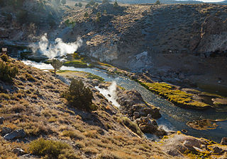
Hot Creek, starting as Mammoth Creek, is a stream in Mono County of eastern California, in the Western United States. It is within the Inyo National Forest.

<span class="mw-page-title-main">U.S. Route 395 in California</span> Highway in California

U.S. Route 395 (US 395) is a United States Numbered Highway, stretching from Hesperia, California to the Canadian border in Laurier, Washington. The California portion of US 395 is a 557-mile (896 km) route which traverses from Interstate 15 (I-15) in Hesperia, north to the Oregon state line in Modoc County near Goose Lake. The route clips into Nevada, serving the cities Carson City and Reno, before returning to California.

The Paiute-Shoshone Indians of the Lone Pine Community of the Lone Pine Reservation is a federally recognized tribe of Mono and Timbisha Native American Indians near Lone Pine in Inyo County, California. They are related to the Owens Valley Paiute.

Owens River course River in California, United States

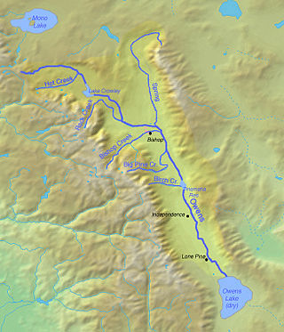
The Owens River course includes headwaters points near the Upper San Joaquin Watershed, reservoirs and diversion points, and the river's mouth at Owens Lake. The river drains the Crowley Lake Watershed of 1,900 sq mi (4,900 km2) and the north portion of the Owens Lake Watershed of 1,340 sq mi (3,500 km2).

Mill Creek (Mono Lake) River in California, United States

Mill Creek is a 14.5-mile-long (23.3 km) perennial stream that flows east from the Sierra Nevada Mountain Range into Mono Lake, in Mono County, California. It courses through Lundy Canyon and Lundy Lake, before passing through Mono City, California on its way to Mono Lake.

References

  1. "Query Form For The United States And Its Territories". U.S. Board on Geographic Names. Retrieved 2010-05-13.
  2. 1 2 3 "Owens River". Geographic Names Information System . United States Geological Survey, United States Department of the Interior. 1981-01-19. Retrieved 2010-06-05.
  3. 1 2 "USGS Gage #10227500 on the Owens River near Big Pine, CA". National Water Information System. U.S. Geological Survey. 1975-12-19. Retrieved 2011-12-15.
  4. U.S. Geological Survey. National Hydrography Dataset high-resolution flowline data. The National Map, accessed March 17, 2011,
  5. "L.A. Returns Water to the Owens Valley". NPR.org. NPR
  6. United States Geological Survey. "United States Geological Survey Topographic Maps". TopoQuest . Retrieved 2010-06-05.
  7. 1 2 USGS Topo Maps for United States (Map). Cartography by United States Geological Survey. ACME Mapper. Retrieved 2010-06-05.
  8. "Boundary Descriptions and Names of Regions, Subregions, Accounting Units and Cataloging Units". USGS.gov. Retrieved 2010-06-07.
  9. 1 2 3 "Evaluation of the Hydrologic System and Selected Water-Management Alternatives in the Owens Valley, California" (PDF). California Water Science Center. United States Geological Survey. 2010-05-27. Retrieved 2010-06-05.
  10. "Mount Whitney". Geographic Names Information System . United States Geological Survey, United States Department of the Interior. 1981-01-19. Retrieved 2010-06-05.
  11. 1 2 "Points of Interest in the Owens River Valley" (PDF). Center for Land Use Interpretation. Retrieved 2010-06-05.
  12. "Owens Lake". Geographic Names Information System . United States Geological Survey, United States Department of the Interior. 1981-01-19. Retrieved 2010-06-05.
  13. "Mono County, California". State & County QuickFacts. U.S. Census Bureau. Archived from the original on 2011-06-06. Retrieved 2010-06-05.
  14. "Inyo County, California". State & County QuickFacts. U.S. Census Bureau. Archived from the original on 2016-01-19. Retrieved 2010-06-05.
  15. 1 2 Dutch, Steven (2006-01-06). "Owens Valley, California". Natural and Applied Sciences. University of Wisconsin, Stevens Point. Archived from the original on 2010-06-11. Retrieved 2010-06-05.
  16. Heil, Darla. "Owens Valley geology". Owens Valley Committee. Archived from the original on 2010-11-14. Retrieved 2010-06-05.
  17. "Long Valley". Global Volcanism Program. Smithsonian National Museum of Natural History. Retrieved 2010-06-05.
  18. "Long Valley Caldera" (PDF). 2007 Annual Meeting. Geothermal Resources Council. September 29–30, 2007. Archived from the original (PDF) on 2011-07-21. Retrieved 2010-06-05.
  19. "Long Valley Caldera and Mono-Inyo Craters Volcanic Field, California". Volcano World. Oregon State University. Retrieved 2010-06-05.
  20. "The Little River That Could: Nevada's Amargosa River (section The Owens River Story)". Thoughts and Places.Org. Retrieved 2010-06-05.
  21. "The Mojave River and Associated Lakes". Publications Warehouse. United States Geological Survey. 2009-12-18. Retrieved 2010-06-05.
  22. 1 2 3 Cheuvront, Mike. "Bishop and the Owens Valley". Bishop California. Archived from the original on 2008-10-23. Retrieved 2010-06-04.
  23. Bouey, Paul D. (1979). "Population Pressure and Agriculture in Owens Valley". Journal of California and Great Basin Anthropology. 1 (1): 162–170. JSTOR   27824952.
  24. 1 2 Lawton, Harry W.; Wilke, Philip J.; DeDecker, Mary; Mason, William M. (1976). "Agriculture Among the Paiute of Owens Valley". Journal of California Anthropology. 3 (1): 13–50. JSTOR   27824857.
  25. Hundley, p. 18
  26. Hundley, p. 19
  27. Hundley, p. 20
  28. Gagnon, Al. "Chronological History of Owens Valley" (PDF). Owens Valley History. Retrieved 2010-06-04.
  29. Fretheim, Paul (2005). "Cerro Gordo and Panamint City – The Silver Cities of Inyo" (PDF). Friends of the Eastern California Museum. Archived from the original (PDF) on 2011-07-26. Retrieved 2010-06-04.
  30. U.S. Geological Survey Geographic Names Information System: Baker Creek
  31. Richard E. Warner, Kathleen M. Hendrix (1984). California riparian systems: ecology, conservation, and productive management. University of California Press. p. 80. ISBN   978-0-520-05035-8 . Retrieved 2011-02-12.{{cite book}}: CS1 maint: uses authors parameter (link)
  32. 1 2 Don D. Fowler, Catherine S. Fowler, Stephen Powers (Summer–Autumn 1970). "Stephen Powers' "The Life and Culture of the Washo and Paiutes"". Ethnohistory. 17 (3/4): 117–149. doi:10.2307/481206. JSTOR   481206.{{cite journal}}: CS1 maint: uses authors parameter (link)
  33. Jesse D. Mason (1881). History of Amador County. Oakland, California: Thompson & West. Retrieved 2011-02-12.
  34. Tappe, Donald T. (1942). "The Status of Beavers in California" (PDF). Game Bulletin No. 3. California Department of Fish & Game: 14. Retrieved 2011-02-12.
  35. "LA to hire beaver trappers for Owens Valley". ABC News. 2011-02-09. Archived from the original on 2011-06-28. Retrieved 2011-02-12.
  36. Mark Hill, William S. Platts (1997). Technical Memorandum #3 Distribution and Abundance of Beaver in the Lower Owens River (Report). Ecosystem Sciences. Archived from the original on 2011-07-22. Retrieved 2011-02-12.{{cite report}}: CS1 maint: uses authors parameter (link)
  37. "The Story of the Los Angeles Aqueduct". Los Angeles Department of Water and Power. Archived from the original on 2009-02-01. Retrieved 2007-10-27.
  38. Hundley, pp. 155-171
  39. Sahagun, Louis (2007-07-08). "River is resurrected: The long-dry Owens now teems with birds and fish". Los Angeles Times. Retrieved 2010-06-05.
  40. Kelly, William J. (2004-04-29). "Money in the Lake: You will end up paying for repairing Owens Valley". LAWeekly. Retrieved 2010-06-04.
  41. Louis Sahagun (2006-12-07). "In Owens Valley, water again flows" (PDF). Los Angeles Times. Archived from the original (PDF) on 2011-07-11. Retrieved 2011-02-12.
  42. Louis Sahagun (2007-07-08). "The long-dry Owens now teems with birds and fish". Los Angeles Times. Retrieved 2011-02-12.

Works cited