National parks and monuments
| Name | Image | Location | Established [1] [a] | Area [2] | Elevation | Description |
|---|---|---|---|---|---|---|
| Kings Canyon National Park |  | 33 miles east of Sanger. Includes parts of Fresno and Tulare counties. | October 1, 1890 [b] | 461,902.2 acres (721.7 sq mi; 1,869.3 km2) | 1,370–14,505 ft (418–4,421 m) [3] [4] [c] | The park encompasses North Palisade mountain; the Palisade Glacier, the largest glacier in the Sierra Nevada; the North and Middle Forks of the Kings River; the Roaring River, a fast-flowing tributary; and the Grant Grove of giant sequoias including the General Grant, the second largest sequoia in the world. Kings Canyon has the greatest riverbed-to-summit height differential of any canyon in North America. |
| Sequoia National Park | 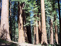 | Tulare County, 27 miles east of Visalia. [d] | September 25, 1890 | 404,062.2 acres (631.3 sq mi; 1,635.2 km2) | 1,370–14,505 ft (418–4,421 m) [3] [4] [c] | The Giant Forest, inhabited by the giant sequoias that give the park its name, is home to five of the ten largest trees on Earth, including General Sherman, the world's largest tree. The Giant Forest is only one of dozens of sequoia groves in the park, including Muir Grove and Garfield Grove. Crystal Cave, a marble karst cave, is one of more than 240 known caves in the area. In the backcountry, the Great Dividing Range and Kern Canyon are among many remote alpine peaks and valleys. The park spans 13,000 feet (4,000 m) of vertical relief, from the deep canyons of the lower foothills to Mount Whitney, whose summit is the highest point in the contiguous United States. |
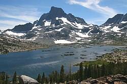
| Yosemite National Park | 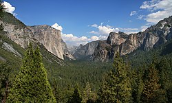 | 18 miles northeast of Mariposa. [e] Includes parts of Madera, Mariposa, Mono, and Tuolumne counties. | June 30, 1864 [f] | 761,747.5 acres (1,190.2 sq mi; 3,082.7 km2) | 2,127–13,114 ft (648–3,997 m) [5] | Yosemite Valley, the centerpiece of the park, is a densely forested 3,500 ft (1,100 m) deep glacial valley flanked for its whole length by soaring granite masses such as Half Dome and El Capitan. The valley is also known for its many waterfalls, including Bridalveil Fall and Yosemite Falls, the highest waterfall in North America. [g] Tuolumne Meadows, a broad subalpine meadow astride the Tuolumne River studded with numerous granite domes and outcroppings, is the centerpiece of the Yosemite high country, which also includes Glen Aulin valley and a number of high alpine peaks such as Mount Dana and Mount Lyell. Near Wawona to the south, the Mariposa Grove is home to hundreds of giant sequoias, including the Grizzly Giant. Tioga Pass, the highest highway pass in the Sierra Nevada, is a popular scenic route as well as an important link between the Eastern Sierra and the major population centers to the west. |
| Devils Postpile National Monument |  | Madera County, 7 miles west of Mammoth Lakes. [h] | July 6, 1911 [i] | 800.2 acres (1.3 sq mi; 3.2 km2) | 7,200–8,202 ft (2,190–2,500 m) [6] [7] | Devil's Postpile, a large and striking formation of columnar basalt formed by an ancient lava flow, is the focal point of this national monument. The formation sits alongside the Middle Fork of the San Joaquin River as it courses through the monument. Further downstream, Rainbow Falls is another notable attraction. Devil's Postpile is located near Minaret Summit, the lowest gap along the Sierra Crest for an over 150 miles (240 km) stretch of contiguous roadless wilderness. As such, the area is also an important resupply point for the John Muir Trail and Pacific Crest Trail, which merge into one trail for a short distance as they pass through the monument. |
| Giant Sequoia National Monument [j] |  | Two discontiguous units covering parts of Fresno and Tulare counties. | April 15, 2000 [8] | 327,769 acres (512.1 sq mi; 1,326.4 km2) | 1,080–10,365 ft (330–3,160 m) [6] | The monument includes 38 of the 39 giant sequoia groves in the Sequoia National Forest, amounting to about half of the sequoia groves currently in existence. This includes one of the ten largest giant sequoias, the Boole Tree. Its two parts are around Kings Canyon and Sequoia National Parks. [9] |