Carpinteria State Beach

Last updated
Carpinteria State Beach
Carpinteria State Beach.jpg
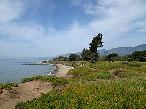
Carpinteria State Beach coastline
Relief map of California.png
Red pog.svg
Usa edcp relief location map.png
Red pog.svg
Location Santa Barbara and Ventura Counties, California, United States
Nearest city Carpinteria, California
Coordinates 34°23′31″N119°31′16″W / 34.39194°N 119.52111°W / 34.39194; -119.52111 Coordinates: 34°23′31″N119°31′16″W / 34.39194°N 119.52111°W / 34.39194; -119.52111
Area62 acres (25 ha)
Established1932
Governing body California Department of Parks and Recreation

Carpinteria State Beach is a protected beach in the state park system of California, in Santa Barbara County, Southern California.

Contents

Features

Geography

The park is located in the city of Carpinteria, 12 miles (19 km) south of Santa Barbara. The park has 4,685 feet (1,428 m) of beachfront. [1] The address is 205 Palm Ave Carpinteria, CA 93013.

History

The 62-acre (25 ha) park was established in 1932. [1]

Recreation

Recreational activities include bird watching, ocean swimming, surf fishing, nature walks, camping, and tidepool exploration. [2]

Picture from the observation cliff of the rookery at the Carpinteria Harbor Seal preserve Carpinteria Harbor Seal Preserve.jpg
Picture from the observation cliff of the rookery at the Carpinteria Harbor Seal preserve

The Carpinteria Harbor Seal Preserve and rookery is located within and south of the park, protecting the Harbor seal (Phoca vitulina). It is one of the four harbor seal rookeries remaining along the Southern California coast. [3]

See also

Related Research Articles

Santa Barbara County, California County in California, United States

Santa Barbara County, California, officially the County of Santa Barbara, is located in Southern California. As of the 2010 census, the population was 423,895. The county seat is Santa Barbara, and the largest city is Santa Maria.

Carpinteria, California City in California, United States

Carpinteria is a small oceanside city located in southeastern Santa Barbara County, California, east of Santa Barbara and northwest of Ventura. The population was 13,040 at the 2010 census.

Santa Barbara, California City in California, United States

Santa Barbara is a coastal city in Santa Barbara County, California, of which it is also the county seat. Situated on a south-facing section of coastline, the longest such section on the West Coast of the United States, the city lies between the steeply rising Santa Ynez Mountains and the Pacific Ocean. Santa Barbara's climate is often described as Mediterranean, and the city has been promoted as the "American Riviera". According to the 2020 U.S. Census, the city's population was 88,665.

Channel Islands National Park National park in California, United States

Channel Islands National Park consists of five of the eight Channel Islands off the Pacific coast of the U.S. state of California. Although the islands are close to the shore of the densely populated state, they have been relatively undeveloped. The park covers 249,561 acres (100,994 ha), of which 79,019 acres (31,978 ha) are federal land. The Nature Conservancy owns and manages 76% of Santa Cruz Island, the largest of the eight.

Año Nuevo State Park State park in California

Año Nuevo State Park is a state park of California, United States, encompassing Año Nuevo Island and Año Nuevo Point, which are known for their pinniped rookeries. Located in San Mateo County, the low, rocky, windswept point juts out into the Pacific Ocean about 55 miles (89 km) south of San Francisco and the Golden Gate. Año Nuevo State Natural Reserve, formerly a separate unit of the California state park system, was merged into Año Nuevo State Park in October 2008. The coastal geographic center, or coastal-midpoint of California is located at the Northern end of this park at N 37°09′58″, W 122°21'40", as the absolute geographic center of California falls at N 37°09′58″, W 119°26′58″W.

Santa Barbara Island Island of the Channel Islands in California, United States

Santa Barbara Island is a small island of the Channel Islands archipelago in Southern California. It is protected within Channel Islands National Park, and its marine ecosystem is part of the Channel Islands National Marine Sanctuary.

Gaviota State Park State park in Gaviota, California, United States

Gaviota State Park is a state park of California, United States. It is located in southern Santa Barbara County, California, about 33 miles (53 km) west of the city of Santa Barbara. One of three state parks along the Gaviota Coast, it extends from the Pacific coast to the crest of the Santa Ynez Mountains, and is adjacent to Los Padres National Forest. The 2,787-acre (1,128 ha) park was established in 1953.

Emma Wood State Beach

Emma Wood State Beach is a California State Beach in Ventura, California. It is located on the Santa Barbara Channel on the west side of the Ventura River estuary and south of the railroad tracks of the Coast Line and the US Highway 101 freeway.

Doheny State Beach State park in California, United States

Doheny State Beach is a protected beach in the state park system of California, United States, located on the Pacific Ocean in the city of Dana Point. The beach is a popular surf spot located at the mouth of San Juan Creek, which flows from the Santa Ana Mountains southwest to the beach, where it forms a fresh-water lagoon. It is also one of the most polluted beaches in Southern California.

McGrath State Beach State beach in Ventura County, California, United States

McGrath State Beach is a protected beach park located on the south bank of the mouth of Santa Clara River in the city of Oxnard, California. McGrath State Beach is one of the best bird-watching areas in California, with the lush riverbanks of the Santa Clara River and sand dunes along the shore. A nature trail leads to the Santa Clara Estuary Natural Preserve. Camping sites are available. Two miles of beach provide surfing and fishing opportunities. Just south of the station is the undeveloped Mandalay Beach Park which is about a mile downcoast beach walk from the park or a bike ride along Harbor Blvd. Located south of Ventura on Harbor Boulevard, the beach is on the Pacific Coast Bicycle Route and the California Coastal Trail.

Pescadero State Beach

Pescadero State Beach is alongside State Route 1, located 14.5 miles south of Half Moon Bay and 1.5 miles west of the city of Pescadero in San Mateo County, California. The beach has a mile-long shoreline with sandy coves, rocky cliffs, tide pools, fishing spots and picnic facilities.

Hearst San Simeon State Park

Hearst San Simeon State Park is a state park of California, United States, preserving rocky coast and rare habitats. It is located between Cambria and San Simeon. The 3,409-acre (1,380 ha) park was first established in 1932. The park includes the Santa Rosa Creek Natural Preserve, the San Simeon Natural Preserve and the Pa-nu Cultural Preserve, which were established in 1990.

Asilomar State Marine Reserve

Asilomar State Marine Reserve (SMR) is one of four small marine protected areas (MPAs) located near the cities of Monterey and Pacific Grove, at the southern end of Monterey Bay on California’s central coast. The four MPAs together encompass 2.96 square miles (7.7 km2). The SMR protects all marine life within its boundaries. Fishing and take of all living marine resources is prohibited.

Estero de Limantour State Marine Reserve & Drakes Estero State Marine Conservation Area Marine conservation area in California, United States

Estero de Limantour State Marine Reserve (SMR) and Drakes Estero State Marine Conservation Area (SMCA) are two adjoining marine protected areas along the Point Reyes National Seashore in Marin County on California’s north central coast. These marine protected areas cover a combined 4.04 square miles (10.5 km2), with 1.49 square miles (3.9 km2) in the SMR and 2.55 square miles (6.6 km2) in the SMCA. Drakes Estero SMCA prohibits the take of all living marine resources from Drakes Estero except the recreational take of clams and formerly the commercial aquaculture of shellfish pursuant to a disputed state water bottom lease and permit, which has been the subject of ongoing legal proceedings since 2012, when the lease was allowed to expire.

Carpinteria Tar Pits Series of natural asphalt lakes situated in the southern part of Santa Barbara County in southern California

The Carpinteria Tar Pits are a series of natural asphalt lakes situated in the southern part of Santa Barbara County in southern California, USA.

Carpinteria Creek is an 8.1-mile-long (13.0 km) stream that runs from headwaters in the Santa Ynez Mountains, flows south past Snowball Mountain, then continues southwest to its estuary at Carpinteria State Beach on the Santa Barbara Channel at Carpinteria.

Naples State Marine Conservation Area (SMCA) is a marine protected area that protects Naples Reef which is about three-quarters of a mile offshore along the middle of the pristine and rural Gaviota Coast in Santa Barbara County on California’s south coast. The SMCA covers 2.58 square miles. The MPAs protects marine life by limiting the removal of wildlife from within its borders.

Point Conception State Marine Reserve (SMR) is a marine protected area that extends offshore of Point Conception in Santa Barbara County on California’s south coast. The SMR covers 22.51 square miles. The SMR prohibits the take of all living marine resources.

Dana Point State Marine Conservation Area

Dana Point State Marine Conservation Area (SMCA) is one of four adjoining marine protected areas off the coast of Orange County, CA, on California’s South Coast. By itself, the SMCA measures 3.45 square miles. The SMCA protects marine life by limiting the removal of marine wildlife from within its borders, including tide pools. Dana Point SMCA prohibits take of living marine resources except: only the following species may be taken recreationally below the mean lower low tide line only: finfish by hook-and-line or by spearfishing, and lobster and sea urchin. The commercial take of coastal pelagic species by round haul net, and spiny lobster and sea urchin only is allowed.

Laguna Beach State Marine Reserve (SMR) and Laguna Beach State Marine Conservation Area (SMCA) are two adjoining marine protected areas that extend offshore of Laguna Beach in Orange County on California’s south coast. The SMR covers 6.27 square miles, and the SMCA covers an additional 3.44 square miles. These two MPAs are part of a four-MPA complex on the coast of southern Orange County. Each protects marine life by prohibiting or limiting the removal of marine wildlife from within its borders.

References

  1. 1 2 "California State Park System Statistical Report: Fiscal Year 2009/10" (PDF). California State Parks: 18. Retrieved 2011-11-12.Cite journal requires |journal= (help)
  2. "Carpinteria SB". California State Parks. Archived from the original on 2011-11-02. Retrieved 2011-11-12.
  3. CarpinteriaCoast.com: Carpinteria Harbor Seal Preserve and rookery . accessed 2.2.2014
Carpinteria State Beach entrance sign. Carpinteria State Beach Hossen27.jpg
Carpinteria State Beach entrance sign.