
The Central Valley is a broad, elongated, flat valley that dominates the interior of California. It is 40–60 mi (60–100 km) wide and runs approximately 450 mi (720 km) from north-northwest to south-southeast, inland from and parallel to the Pacific coast of the state. It covers approximately 18,000 sq mi (47,000 km2), about 11% of California's land area. The valley is bounded by the Coast Ranges to the west and the Sierra Nevada to the east.

The desert cottontail, also known as Audubon's cottontail, is a New World cottontail rabbit, and a member of the family Leporidae. Unlike the European rabbit, they do not form social burrow systems, but compared with some other leporids, they are extremely tolerant of other individuals in their vicinity.
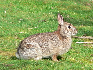
The brush rabbit, or western brush rabbit, or Californian brush rabbit, is a species of cottontail rabbit found in western coastal regions of North America, from the Columbia River in Oregon to the southern tip of the Baja California Peninsula. Its range extends as far east as the eastern sides of the Sierra Nevada and Cascade mountain ranges.
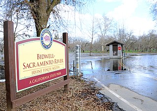
Bidwell–Sacramento River State Park is a state park of California, United States, preserving riparian habitat on the Sacramento River and its tributary Big Chico Creek. The park is located on the border of Butte County and Glenn County. Popular activities include fishing for salmon, steelhead and shad; and floating the river on inner tubes, canoes or kayaks. The 349-acre (141 ha) property was established as a state park in 1979.

The Kern River, previously Rio de San Felipe, later La Porciuncula, is an Endangered, Wild and Scenic river in the U.S. state of California, approximately 165 miles (270 km) long. It drains an area of the southern Sierra Nevada mountains northeast of Bakersfield. Fed by snowmelt near Mount Whitney, the river passes through scenic canyons in the mountains and is a popular destination for whitewater rafting and kayaking. It is the southernmost major river system in the Sierra Nevada, and is the only major river in the Sierra that drains in a southerly direction.

Henry W. Coe State Park is a state park of California, United States, preserving a vast tract of the Diablo Range. The park is located closest to the city of Morgan Hill, and is located in both Santa Clara and Stanislaus counties. The park contains over 87,000 acres (35,000 ha), making it the largest state park in northern California, and the second-largest in the state. Managed within its boundaries is a designated wilderness area of about 22,000 acres (8,900 ha). This is officially known as the Henry W. Coe State Wilderness, but locally as the Orestimba Wilderness. The 89,164-acre (36,083 ha) park was established in 1959.

The Stanislaus River is a tributary of the San Joaquin River in north-central California in the United States. The main stem of the river is 96 miles (154 km) long, and measured to its furthest headwaters it is about 150 miles (240 km) long. Originating as three forks in the high Sierra Nevada, the river flows generally southwest through the agricultural San Joaquin Valley to join the San Joaquin south of Manteca, draining parts of five California counties. The Stanislaus is known for its swift rapids and scenic canyons in the upper reaches, and is heavily used for irrigation, hydroelectricity and domestic water supply.

Franks Tract State Recreation Area (SRA) is a state park unit of California, United States, featuring a flooded area in the Sacramento–San Joaquin River Delta. It is accessible only by water. Franks Tract, and a smaller adjoining submerged property called "Little Franks Tract", are situated between the False River and Bethel Island. The recreation area is used primarily for fishing and waterfowl hunting, because of its exposure to frequent strong winds and fluctuating water levels. In times of high water, the entire site can be submerged except for portions of the old levees. The 3,523-acre (1,426 ha) park was established in 1959. It is managed from nearby Brannan Island State Recreation Area, 6 miles (9.7 km) to the northwest.

The New England cottontail, also called the gray rabbit, brush rabbit, wood hare, wood rabbit, or cooney, is a species of cottontail rabbit represented by fragmented populations in areas of New England, specifically from southern Maine to southern New York. This species bears a close resemblance to the eastern cottontail, which has been introduced in much of the New England cottontail home range. The eastern cottontail is now more common in it.

The San José brush rabbit is a critically endangered subspecies of the brush rabbit, in the family Leporidae.
Great Valley Grasslands State Park is a state park of California, United States, preserving a parcel of remnant native grassland in the San Joaquin Valley. Such a temperate grasslands, savannas, and shrublands biome was once widespread throughout the whole Central Valley. The 2,826-acre (1,144 ha) park was established in 1982. Largely undeveloped, it was formed by combining two former state park units: San Luis Island and Fremont Ford State Recreation Area. Its chief attractions for visitors are spring wildflowers, fishing, and wildlife watching.

Hearst San Simeon State Park is a state park of California, United States, preserving rocky coast and rare habitats. It is located between Cambria and San Simeon. The 3,409-acre (1,380 ha) park was first established in 1932. The park includes the Santa Rosa Creek Natural Preserve, the San Simeon Natural Preserve and the Pa-nu Cultural Preserve, which were established in 1990.
The San Luis National Wildlife Refuge Complex is located in the northern San Joaquin Valley, within Merced County and Stanislaus County of California. The complex, with four federal National Wildlife Refuges, is managed by the U.S Fish & Wildlife Service.

The Cosumnes River Preserve is a nature preserve of over 51,000 acres (210 km2) located 20 miles (30 km) south of Sacramento, in the US state of California. The preserve protects a Central Valley remnant that once contained one of the largest expanses of oak tree savanna, riparian oak forest and wetland habitat in North America. Agricultural development has changed the landscape from groves of oaks and tule marshes to productive farmlands.

Turlock Lake State Recreation Area is a regional park and recreation area at Turlock Reservoir in Stanislaus County, central California, United States.
The San Joaquin River National Wildlife Refuge is a protected area of along the San Joaquin River in the northern San Joaquin Valley, California. It is within San Joaquin County and Stanislaus County.
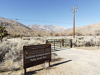
Canebrake Ecological Reserve is a 6,700-acre (27 km2) nature reserve in the South Fork Valley of Kern County, 20 miles (32 km) east of Lake Isabella, California. It is located in the Southern Sierra Nevada region.

The Audubon Kern River Preserve is a riparian nature reserve owned by the National Audubon Society in the US state of California, near Weldon in Kern County.


